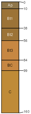
Claycreek fine sandy loam, 0 to 2 percent slopes
Claycreek
(80%)
Triassic Basin Upland Forest, Seasonally Wet
Oxyaquic Hapludalfs
Moderately well drained
Hydric: No
PAWS: 29 cm
interfluves / Summit
SSA
Scale
Published
Export
nc007
1:24,000
1999
2025-09-03