Blackhall-Satanka-Rock outcrop complex, 5 to 20 percent slopes
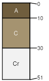
Blackhall
(35%)
Shallow Sandy High Plains Southeast (SwSy)
Ustic Torriorthents
Well drained
Hydric: No
PAWS: 5 cm
hills / Summit
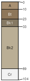
Satanka
(30%)
Sandy High Plains Southeast (Sy)
Ustic Haplargids
Well drained
Hydric: No
PAWS: 12 cm
hills / Shoulder
Rock outcrop
(20%)
Hydric: No
PAWS: 0 cm
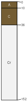
Blazon
(8%)
Hydric: No
PAWS: NA
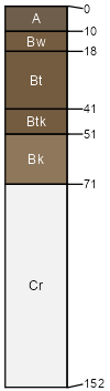
Diamondville
(7%)
Hydric: No
PAWS: NA
SSA
Scale
Published
Export
wy031
1:24,000
1998
2025-09-04