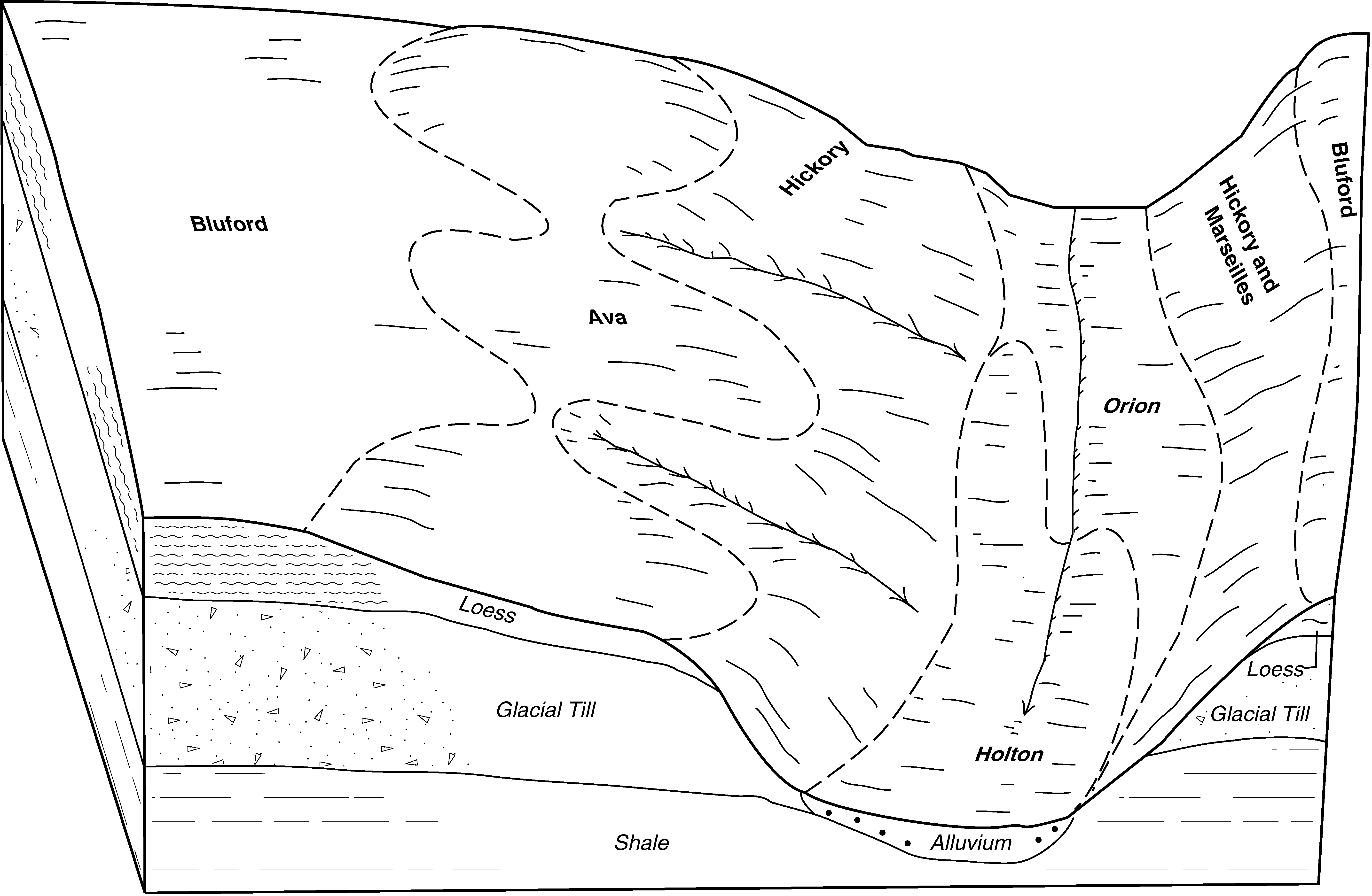
Official Series Description


Lab Data Summary

Aggregate lab data for the AVA soil series. This aggregation is based on all pedons with a current taxon name of AVA, and applied along 1-cm thick depth slices. Solid lines are the slice-wise median, bounded on either side by the interval defined by the slice-wise 5th and 95th percentiles. The median is the value that splits the data in half. Five percent of the data are less than the 5th percentile, and five percent of the data are greater than the 95th percentile. Values along the right hand side y-axis describe the proportion of pedon data that contribute to aggregate values at this depth. For example, a value of "90%" at 25cm means that 90% of the pedons correlated to AVA were used in the calculation. Source: KSSL snapshot . Methods used to assemble the KSSL snapshot used by SoilWeb / SDE

Click the image to view it full size.

Pedons used in the lab summary:

MLRALab IDPedon IDTaxonnameCINSSL / NASIS ReportsLink To SoilWeb GMap
11328IL0510011928IL051001Ava4Primary | Supplementary | Taxonomy | Pedon | Water Retention | Correlation | Andic Soil Properties38.9603343,-89.10123
11328IL1910011928IL191001Ava4Primary | Supplementary | Taxonomy | Pedon | Water Retention | Correlation | Andic Soil Properties38.3724792,-88.2540385
11336IL1210011936IL121001Ava4Primary | Supplementary | Taxonomy | Pedon | Water Retention | Correlation | Andic Soil Properties38.477644,-88.962989
11336IL1210021936IL121002Ava4Primary | Supplementary | Taxonomy | Pedon | Water Retention | Correlation | Andic Soil Properties38.4903023,-88.7740386
11356IL1990021956IL199002Ava3Primary | Supplementary | Taxonomy | Pedon | Water Retention | Correlation | Andic Soil Properties37.7829658,-88.8454903
11377IL0650061977IL065006Ava1Primary | Supplementary | Taxonomy | Pedon | Water Retention | Correlation | Andic Soil Properties37.9402773,-88.6603707
11381IL1450011981IL145001Ava3Primary | Supplementary | Taxonomy | Pedon | Water Retention | Correlation | Andic Soil Properties37.9561517,-89.3337893
11381IL1450311981IL145031Ava3Primary | Supplementary | Taxonomy | Pedon | Water Retention | Correlation | Andic Soil Properties38.1260103,-89.1575394
11384IL1211021984IL121102Ava6Primary | Supplementary | Taxonomy | Pedon | Water Retention | Correlation | Andic Soil Properties38.508575,-88.8333806
11384IL1211031984IL121103Ava6Primary | Supplementary | Taxonomy | Pedon | Water Retention | Correlation | Andic Soil Properties38.5067639,-88.8449167
11385IL1910461985IL191046Ava2Primary | Supplementary | Taxonomy | Pedon | Water Retention | Correlation | Andic Soil Properties38.4063861,-88.3018111
11387IL1930181987IL193018Ava2Primary | Supplementary | Taxonomy | Pedon | Water Retention | Correlation | Andic Soil Properties38.0943,-88.2036139
11386P051585IL121005Ava6Primary | Supplementary | Taxonomy | Pedon | Water Retention | Correlation | Andic Soil Properties38.4791679,-88.960556
11387P015186IL051043Ava6Primary | Supplementary | Taxonomy | Pedon | Water Retention | Correlation | Andic Soil Properties39.1530991,-89.129509
11391P047189IL055025Ava5Primary | Supplementary | Taxonomy | Pedon | Water Retention | Correlation | Andic Soil Properties37.939167,-88.805275
11390P080590IL025010Ava6Primary | Supplementary | Taxonomy | Pedon | Water Retention | Correlation | Andic Soil Properties38.7827797,-88.3997192
11390P085490IL055006Ava6Primary | Supplementary | Taxonomy | Pedon | Water Retention | Correlation | Andic Soil Properties37.9393889,-88.8215278
11390P084690IL081006Ava7Primary | Supplementary | Taxonomy | Pedon | Water Retention | Correlation | Andic Soil Properties38.2631111,-88.8728333
11390P085190IL081011Ava7Primary | Supplementary | Taxonomy | Pedon | Water Retention | Correlation | Andic Soil Properties38.291111,-88.793335
11340A2734S1951IL199003Ava3Primary | Supplementary | Taxonomy | Pedon | Water Retention | Correlation | Andic Soil Properties37.7900009,-88.836113
11340A1407S1959IL135001Ava5Primary | Supplementary | Taxonomy | Pedon | Water Retention | Correlation | Andic Soil Properties39.039444,-89.2794418
114AGN79061979IN055006Ava2Primary | Supplementary | Taxonomy | Pedon | Water Retention | Correlation | Andic Soil Properties39.1305056,-86.9905167
114A87P076787IN119001Ava6Primary | Supplementary | Taxonomy | Pedon | Water Retention | Correlation | Andic Soil Properties39.3319435,-87.0008316
114A82P0463S1982IN021051Ava6Primary | Supplementary | Taxonomy | Pedon | Water Retention | Correlation | Andic Soil Properties39.2845955,-87.0716934
114A82P0460S1982IN021054Ava6Primary | Supplementary | Taxonomy | Pedon | Water Retention | Correlation | Andic Soil Properties39.2847366,-87.0758591
114A82P0462S1982IN021057Ava6Primary | Supplementary | Taxonomy | Pedon | Water Retention | Correlation | Andic Soil Properties39.2847366,-87.0758591
114A92P0920S1992IN119004Ava7Primary | Supplementary | Taxonomy | Pedon | Water Retention | Correlation | Andic Soil Properties39.335556,-87.003891
114B29IL0770011929IL077001Ava4Primary | Supplementary | Taxonomy | Pedon | Water Retention | Correlation | Andic Soil Properties37.8576755,-89.2331749
114B78IL1570541978IL157054Ava3Primary | Supplementary | Taxonomy | Pedon | Water Retention | Correlation | Andic Soil Properties38.1048659,-89.6451327
114B81P0035S1980IL157124AVA6Primary | Supplementary | Taxonomy | Pedon | Water Retention | Correlation | Andic Soil Properties38.2125015,-89.7116699
115A87IL1930171987IL193017Ava2Primary | Supplementary | Taxonomy | Pedon | Water Retention | Correlation | Andic Soil Properties37.9806806,-88.1679056
n/aAD-s101961-OH001-S10Ava2Primary | Supplementary | Taxonomy | Pedon | Water Retention | Correlation | Andic Soil Propertiesn/a
n/a85IL1910531985IL191053Ava2Primary | Supplementary | Taxonomy | Pedon | Water Retention | Correlation | Andic Soil Propertiesn/a
n/a86IL1990011986IL199001Ava2Primary | Supplementary | Taxonomy | Pedon | Water Retention | Correlation | Andic Soil Propertiesn/a
n/a86IL1990021986IL199002Ava2Primary | Supplementary | Taxonomy | Pedon | Water Retention | Correlation | Andic Soil Propertiesn/a
n/a86IL1990031986IL199003Ava2Primary | Supplementary | Taxonomy | Pedon | Water Retention | Correlation | Andic Soil Propertiesn/a
n/a86IL1990041986IL199004Ava2Primary | Supplementary | Taxonomy | Pedon | Water Retention | Correlation | Andic Soil Propertiesn/a
n/a86IL1990051986IL199005Ava2Primary | Supplementary | Taxonomy | Pedon | Water Retention | Correlation | Andic Soil Propertiesn/a
n/a86IL1990061986IL199006Ava2Primary | Supplementary | Taxonomy | Pedon | Water Retention | Correlation | Andic Soil Propertiesn/a
n/a91P112090IL055007Ava6Primary | Supplementary | Taxonomy | Pedon | Water Retention | Correlation | Andic Soil Propertiesn/a
n/a91P110890IL081018Ava6Primary | Supplementary | Taxonomy | Pedon | Water Retention | Correlation | Andic Soil Propertiesn/a
n/a91P111890IL081028Ava6Primary | Supplementary | Taxonomy | Pedon | Water Retention | Correlation | Andic Soil Propertiesn/a
n/a91P100091IL055004Ava5Primary | Supplementary | Taxonomy | Pedon | Water Retention | Correlation | Andic Soil Propertiesn/a
n/a91P100191IL055005Ava7Primary | Supplementary | Taxonomy | Pedon | Water Retention | Correlation | Andic Soil Propertiesn/a
n/a91P100591IL055009Ava5Primary | Supplementary | Taxonomy | Pedon | Water Retention | Correlation | Andic Soil Propertiesn/a
n/a91P101291IL055016Ava5Primary | Supplementary | Taxonomy | Pedon | Water Retention | Correlation | Andic Soil Propertiesn/a
n/a91P101391IL055017Ava7Primary | Supplementary | Taxonomy | Pedon | Water Retention | Correlation | Andic Soil Propertiesn/a
n/a91P101491IL055018Ava6Primary | Supplementary | Taxonomy | Pedon | Water Retention | Correlation | Andic Soil Propertiesn/a
n/a91P101591IL055019Ava5Primary | Supplementary | Taxonomy | Pedon | Water Retention | Correlation | Andic Soil Propertiesn/a
n/a91P101691IL055021Ava5Primary | Supplementary | Taxonomy | Pedon | Water Retention | Correlation | Andic Soil Propertiesn/a

Water Balance

Monthly water balance estimated using a leaky-bucket style model for the AVA soil series. Monthly precipitation (PPT) and potential evapotranspiration (PET) have been estimated from the 50th percentile of gridded values (PRISM 1981-2010) overlapping with the extent of SSURGO map units containing each series as a major component. Monthly PET values were estimated using the method of Thornthwaite (1948). These (and other) climatic parameters are calculated with each SSURGO refresh and provided by the fetchOSD function of the soilDB package. Representative water storage values (“AWC” in the figures) were derived from SSURGO by taking the 50th percentile of profile-total water storage (sum[awc_r * horizon thickness]) for each soil series. Note that this representation of “water storage” is based on the average ability of most plants to extract soil water between 15 bar (“permanent wilting point”) and 1/3 bar (“field capacity”) matric potential. Soil moisture state can be roughly interpreted as “dry” when storage is depleted, “moist” when storage is between 0mm and AWC, and “wet” when there is a surplus. Clearly there are a lot of assumptions baked into this kind of monthly water balance. This is still a work in progress.

Click the image to view it full size.


Click the image to view it full size.

Sibling Summary

Siblings are those soil series that occur together in map units, in this case with the AVA series. Sketches are arranged according to their subgroup-level taxonomic structure. Source: SSURGO snapshot , parsed OSD records and snapshot of SC database .

Click the image to view it full size.

Select annual climate data summaries for the AVA series and siblings. Series are sorted according to hierarchical clustering of median values. Source: SSURGO map unit geometry and 1981-2010, 800m PRISM data .

Click the image to view it full size.

Geomorphic description summaries for the AVA series and siblings. Series are sorted according to hierarchical clustering of proportions and relative hydrologic position within an idealized landform (e.g. top to bottom). Most soil series (SSURGO components) are associated with a hillslope position and one or more landform-specific positions: hills, mountain slopes, terraces, and/or flats. Proportions can be interpreted as an aggregate representation of geomorphic membership. The values printed to the left (number of component records) and right (Shannon entropy) of stacked bars can be used to judge the reliability of trends. Small Shannon entropy values suggest relatively consistent geomorphic association, while larger values suggest lack thereof. Source: SSURGO component records .

Click the image to view it full size.

Click the image to view it full size.

There are insufficient data to create the 3D mountains figure.

Click the image to view it full size.

Click the image to view it full size.

Competing Series

Soil series competing with AVA share the same family level classification in Soil Taxonomy. Source: parsed OSD records and snapshot of the SC database .

Click the image to view it full size.

Select annual climate data summaries for the AVA series and competing. Series are sorted according to hierarchical clustering of median values. Source: SSURGO map unit geometry and 1981-2010, 800m PRISM data .

Click the image to view it full size.

Geomorphic description summaries for the AVA series and competing. Series are sorted according to hierarchical clustering of proportions and relative hydrologic position within an idealized landform (e.g. top to bottom). Proportions can be interpreted as an aggregate representation of geomorphic membership. Most soil series (SSURGO components) are associated with a hillslope position and one or more landform-specific positions: hills, mountain slopes, terraces, and/or flats. The values printed to the left (number of component records) and right (Shannon entropy) of stacked bars can be used to judge the reliability of trends. Shannon entropy values close to 0 represent soil series with relatively consistent geomorphic association, while values close to 1 suggest lack thereof. Source: SSURGO component records .

Click the image to view it full size.

Click the image to view it full size.

There are insufficient data to create the 3D mountains figure.

Click the image to view it full size.

There are insufficient data to create the 3D flats position figure.

Soil series sharing subgroup-level classification with AVA, arranged according to family differentiae. Hovering over a series name will print full classification and a small sketch from the OSD. Source: snapshot of SC database .

Block Diagrams

Click a link below to display the diagram. Note that these diagrams may be from multiple survey areas.

  1. IL-2010-08-31-01 | Clay County - 1998

    Typical pattern of soils and parent material in the Bluford-Hickory-Ava association (Soil Survey of Clay County, Illinois; 1998).

  2. IL-2010-08-31-08 | Crawford County - 1996

    Typical pattern of soils and parent material in the Bluford-Ava-Wynoose association (Soil Survey of Crawford County, Illinois; 1996).

  3. IL-2010-08-31-11 | Cumberland County - 2002

    Typical pattern of soils and parent material in the Hickory-Bluford-Ava association (Soil Survey of Cumberland County, Illinois; 2002).

  4. IL-2010-09-01-08 | Fayette County - 1997

    Typical pattern of soils and parent material in the Bluford-Hickory-Ava association (Soil Survey of Fayette County, Illinois; 1997).

  5. IL-2010-09-01-10 | Franklin and Jefferson Counties - 2003

    Typical pattern of soils and parent material in the Hoyleton-Cisne association (Soil Survey of Franklin and Jefferson Counties, Illinois; 2003).

  6. IL-2010-09-01-11 | Franklin and Jefferson Counties - 2003

    Typical pattern of soils and parent material in the Bluford-Wynoose association (Soil Survey of Franklin and Jefferson Counties, Illinois; 2003).

  7. IL-2010-09-01-13 | Franklin and Jefferson Counties - 2003

    Typical pattern of soils and parent material in the Ava-Bluford-Plumfield association (Soil Survey of Franklin and Jefferson Counties, Illinois; 2003).

  8. IL-2010-09-01-80 | Washington County - 1998

    Typical pattern of soils and parent material in the Bluford-Hickory-Blair association (Soil Survey of Washington County, Illinois; 1998).

  9. IL-2010-09-09-02 | Wayne County -

    Typical pattern of soils and parent material in the Ava-Blair-Hickory association (Soil Survey of Wayne County, Illinois).

  10. IL-2011-08-04-02 | Crawford County - 1996

    Typical pattern of soils and parent material in the Bluford-Ava-Wynoose association (Soil Survey of Crawford County, Illinois; 1996).

  11. IL-2011-08-04-09 | Effingham County - 1991

    Pattern of soils and parent material in the Bluford-Hickory-Ava association (Soil Survey of Effingham County, Illinois; 1991).

  12. IL-2011-08-04-15 | Hamilton County - 1986

    Pattern of soils and parent material in the Bluford-Ava association (Soil Survey of Hamilton County, Illinois; 1986).

  13. IL-2011-08-04-18 | Hamilton County - 1986

    Pattern of soils and parent material in the Bluford-Hoyleton-Cisne association (Soil Survey of Hamilton County, Illinois; 1986).

  14. IL-2011-08-04-86 | Perry County - 1988

    Typical pattern of soils and parent material in the Bluford-Wynoose-Ava association (Soil Survey of Perry County, Illinois; 1988).

  15. IL-2011-08-05-05 | Washington County - 1998

    Typical pattern of soils and parent material in the Bluford-Hickory-Blair association (Soil Survey of Washington County, Illinois; 1998).

  16. IN-2010-09-24-14 | Owen County -

    Typical pattern of soils and parent materials in the Solsberry-Hickory-Ava association (Soil Survey of Owen County, Indiana).

  17. IN-2010-09-24-19 | Owen County -

    Typical pattern of soils and parent materials in the Cincinnati-Ava-Hickory association (Soil Survey of Owen County, Indiana).

Map Units

Map units containing AVA as a major component. Limited to 250 records.

Map Unit Name Symbol Map Unit Area (ac) Map Unit Key National Map Unit Symbol Soil Survey Area Publication Date Map Scale
Ava silt loam, 2 to 5 percent slopes14B33731738422t95hil00519811:12000
Ava silt loam, 5 to 10 percent slopes, eroded14C225371738432t95lil00519811:12000
Ava silt loam, 2 to 5 percent slopes14B1110614525202t95hil02320061:12000
Ava silt loam, 5 to 10 percent slopes, eroded14C2263514525212t95lil02320061:12000
Ava silt loam, 2 to 5 percent slopes14B1237521091852t95hil02519931:12000
Ava silt loam, 5 to 10 percent slopes, eroded14C2444921091862t95lil02519931:12000
Ava silty clay loam, 5 to 10 percent slopes, severely eroded14C31059210918728ss9il02519931:12000
Ava silt loam, 2 to 5 percent slopes14B14351746392t95hil02719921:15840
Ava silt loam, 2 to 5 percent slopes14B156051664322t95hil03320041:12000
Ava silt loam, 5 to 10 percent slopes, eroded14C242541664332t95lil03320041:12000
Ava-Blair complex, 2 to 7 percent slopes, eroded844B2134251748645vysil03519921:15840
Ava silt loam, 2 to 5 percent slopes14B44431747952t95hil03519921:15840
Ava silt loam, 5 to 10 percent slopes, eroded14C27871747962t95lil03519921:15840
Ava silt loam, 2 to 5 percent slopes14B64251754252t95hil04719671:15840
Ava silt loam, 5 to 10 percent slopes, eroded14C246161754282t95lil04719671:15840
Ava silt loam, 7 to 12 percent slopes, eroded14D218161754305wk1il04719671:15840
Ava silt loam, 2 to 5 percent slopes, eroded14B29971754262t95jil04719671:15840
Ava soils, 4 to 7 percent slopes, severely eroded14C31171754295wk0il04719671:15840
Ava silt loam, 2 to 5 percent slopes14B290001734412t95hil04919861:15840
Ava silt loam, 5 to 10 percent slopes, eroded14C215551734422t95lil04919861:15840
Ava silt loam, 2 to 5 percent slopes14B283631733772t95hil05119911:15840
Ava silt loam, 5 to 10 percent slopes, eroded14C224011733782t95lil05119911:15840
Ava silt loam, 2 to 5 percent slopes14B200348068552t95hil05520051:12000
Ava silt loam, 5 to 10 percent slopes, eroded14C286448068582t95lil05520051:12000
Ava silt loam, 2 to 5 percent slopes, eroded14B281268068562t95jil05520051:12000
Ava silt loam, 5 to 10 percent slopes, eroded14C29282116032t95lil05919661:20000
Ava silt loam, 2 to 5 percent slopes14B6142116012t95hil05919661:20000
Ava soils, 7 to 16 percent slopes, severely eroded14D3212211604735yil05919661:20000
Ava silt loam, 5 to 10 percent slopes, severely eroded14C3230141751235w74il06519821:15840
Ava silt loam, 5 to 10 percent slopes, eroded14C290301751222t95lil06519821:15840
Ava silt loam, 2 to 5 percent slopes14B88511751202t95hil06519821:15840
Ava silt loam, 2 to 5 percent slopes, eroded14B260191751212t95jil06519821:15840
Ava-Hickory complex, 10 to 18 percent slopes, severely eroded929D332901751515w81il06519821:15840
Ava silt loam, 10 to 18 percent slopes, severely eroded14D315801751245w75il06519821:15840
Ava silt loam, 2 to 5 percent slopes14B338215378122t95hil07720061:12000
Ava silty clay loam, 5 to 10 percent slopes, severely eroded14C3135015378141nm6xil07720061:12000
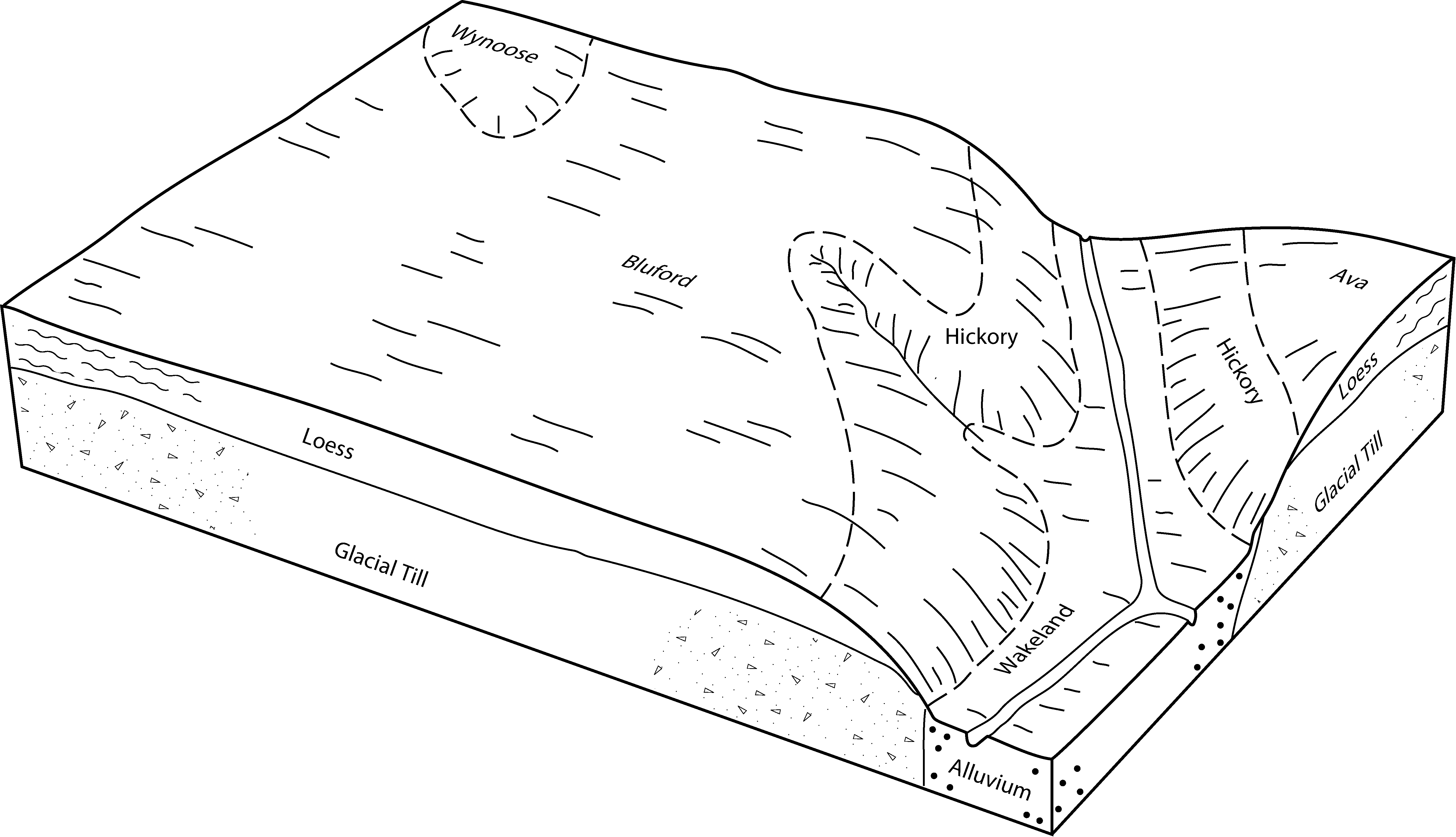
Hickory-Ava silt loams, 10 to 18 percent slopes, eroded929D228615971601qlz9il07720061:12000
Hickory-Ava silty clay loams, 10 to 18 percent slopes, severely eroded929D3415406041nq3xil07720061:12000
Ava silt loam, 2 to 5 percent slopes14B1512314449322t95hil07920051:12000
Ava silt loam, 5 to 10 percent slopes, eroded14C219448693562t95lil07920051:12000
Ava silt loam, 2 to 5 percent slopes14B2497415404612t95hil08120051:12000
Ava silt loam, 5 to 10 percent slopes, eroded14C2841815404632t95lil08120051:12000
Ava silt loam, 2 to 5 percent slopes, eroded14B2794115404622t95jil08120051:12000
Ava silt loam, 5 to 10 percent slopes, eroded14C2125041766612t95lil10119521:42240
Ava silt loam, 2 to 5 percent slopes14B53971766592t95hil10119521:42240
Hickory-Ava complex, 7 to 12 percent slopes, severely eroded929D350081767835xypil10119521:42240
Ava silty clay loam, 7 to 12 percent slopes, severely eroded14D328121766655xtwil10119521:42240
Ava silt loam, 7 to 12 percent slopes, eroded14D222861766645xtvil10119521:42240
Ava silty clay loam, 4 to 7 percent slopes, severely eroded14C320851766625xtsil10119521:42240
Hickory-Ava complex, 12 to 18 percent slopes, severely eroded929E315481767855xyril10119521:42240
Hickory-Ava complex, 12 to 18 percent slopes, eroded929E25551767845xyqil10119521:42240
Hickory-Ava complex, 4 to 7 percent slopes, severely eroded929C33021767815xymil10119521:42240
Hickory-Ava complex, 7 to 12 percent slopes, eroded929D22431767825xynil10119521:42240
Ava silt loam, 7 to 12 percent slopes14D1981766635xttil10119521:42240
Ava silt loam, 2 to 5 percent slopes14B1764518591932t95hil12120081:12000
Ava silt loam, 5 to 10 percent slopes, eroded14C2290718591942t95lil12120081:12000
Ava-Hickory silt loams, 10 to 18 percent slopes, eroded929D226162027380261ncil12120081:12000
Ava silt loam, 2 to 5 percent slopes14B485917215182t95hil13520071:12000
Ava silt loam, 5 to 10 percent slopes, eroded14C2222617215222t95lil13520071:12000
Ava silt loam, 2 to 5 percent slopes14B690914054212t95hil14520051:12000
Hickory-Ava silty clay loams, 10 to 18 percent slopes, severely eroded929D3574314061301j661il14520051:12000
Ava silty clay loam, 5 to 10 percent slopes, severely eroded14C3276214054231j5g7il14520051:12000
Ava silt loam, 2 to 5 percent slopes14B751420268162t95hil15919671:12000
Ava silt loam, 5 to 10 percent slopes, eroded14C2527320268192t95lil15919671:12000
Ava silt loam, 7 to 12 percent slopes, eroded14D290920268212612bil15919671:12000
Ava silt loam, 2 to 5 percent slopes, eroded14B277420268172t95jil15919671:12000
Ava soils, 4 to 7 percent slopes, severely eroded14C3269202682026129il15919671:12000
Ava silt loam, 5 to 10 percent slopes, eroded14C2124261788592t95lil16519741:15840
Ava silt loam, 5 to 12 percent slopes, severely eroded14D311558178861603qil16519741:15840
Ava silt loam, 2 to 5 percent slopes14B82831788582t95hil16519741:15840
Ava silt loam, 7 to 12 percent slopes, eroded14D22675178860603pil16519741:15840
Ava silt loam, 2 to 5 percent slopes14B257531789952t95hil17319901:15840
Ava silt loam, 5 to 10 percent slopes, eroded14C245181789962t95lil17319901:15840
Ava silt loam, 5 to 10 percent slopes, eroded14C218951796232t95lil18519621:20000
Ava silt loam, 2 to 5 percent slopes14B17491796202t95hil18519621:20000
Ava silty clay loam, 4 to 7 percent slopes, severely eroded14C351417962460xbil18519621:20000
Ava silt loam, 2 to 5 percent slopes, eroded14B23701796212t95jil18519621:20000
Ava silt loam, 2 to 5 percent slopes14B865315289182t95hil18920061:12000
Ava silt loam, 5 to 10 percent slopes, eroded14C268415290012t95lil18920061:12000
Hickory-Ava silty clay loams, 10 to 18 percent slopes, severely eroded929D34515289761nb0til18920061:12000
Ava silty clay loam, 5 to 10 percent slopes, severely eroded14C31915289191n9yzil18920061:12000
Ava silt loam, 2 to 5 percent slopes14B2243719026442t95hil19120081:12000
Ava silt loam, 5 to 10 percent slopes, eroded14C2602820241172t95lil19120081:12000
Ava silt loam, 2 to 5 percent slopes, eroded14B2398220249152t95jil19120081:12000
Ava silt loam, 2 to 5 percent slopes14B1315415438542t95hil19320061:12000
Ava silt loam, 5 to 10 percent slopes, eroded14C21204015438562t95lil19320061:12000
Ava silty clay loam, 5 to 10 percent slopes, severely eroded14C3783415438571nthvil19320061:12000
Ava silt loam, 2 to 5 percent slopes, eroded14B2719315438552t95jil19320061:12000
Hickory-Ava complex, 10 to 18 percent slopes, severely eroded929D3486615439311ntl7il19320061:12000
Ava silt loam, 2 to 5 percent slopes14B1906514780582t95hil19920071:12000
Ava silt loam, 5 to 10 percent slopes, eroded14C2891814780572t95lil19920071:12000
Ava silty clay loam, 5 to 10 percent slopes, severely eroded14C3820014780591lm1bil19920071:12000
Ava silt loam, 2 to 5 percent slopes, eroded14B2213118573592t95jil19920071:12000
Ava silt loam, 2 to 6 percent slopes, erodedAvB2199731595892t995in02119801:15840
Ava silt loam, 2 to 6 percent slopes, erodedAvB2303431615182t995in05519841:15840
Ava silt loam, 2 to 6 percent slopes, erodedAloB297217081092t995in10119841:15840
Ava silt loam, 2 to 6 percent slopesAvB78131631915gt7in10919791:15840
Ava silt loam, 2 to 6 percent slopes, erodedAloB2167521658732t995in11919971:12000
Ava silt loam, 1 to 4 percent slopesAvB133681598175c9din13319791:15840
Ava silt loam, 6 to 12 percent slopes, erodedAwC251101598195c9gin13319791:15840
Ava silt loam, 2 to 6 percent slopes, erodedAwB223581598182t995in13319791:15840
Ava silt loam, 2 to 6 percent slopes, erodedAlB2103251626502t995in15319661:15840
Ava silt loam, 2 to 6 percent slopes, severely erodedAlB335911626515g7tin15319661:15840
Ava silt loam, 0 to 2 percent slopesAlA7791626495g7rin15319661:15840
Ava silt loam, 2 to 6 percent slopes, erodedAvB234581596482t995in16719711:20000
Urban land-Alfic Udarents-Ava complex, 0 to 12 percent slopesUAAXC598026528672pyy0oh06119801:15840
Ava silt loam, 8 to 15 percent slopes, erodedArC214721693675p7goh06119801:15840
Ava silt loam, 3 to 8 percent slopes, erodedArB213711693665p7foh06119801:15840
Ava silt loam, 0 to 3 percent slopesArA311693655p7doh06119801:15840

Map of Series Extent

Approximate geographic distribution of the AVA soil series. To learn more about how this distribution was mapped, or to compare this soil series extent to others, use the Series Extent Explorer (SEE) application. Source: generalization of SSURGO geometry .