| Zigweid-Nihill complex, 6 to 15 percent slopes | ZnE | 5656 | 355165 | 2t34d | sd047 | 1980 | 1:24000 |
Zigweid-Nihill complex, 6 to 15 percent slopes | ZaD | 45509 | 354361 | 2t34d | sd600 | 1974 | 1:24000 |
Zigweid-Nihill complex, 6 to 15 percent slopes | ZnD | 39572 | 2580991 | 2t34d | sd606 | 2011 | 1:24000 |
Zigweid-Canyon complex, 2 to 15 percent slopes | ZcC | 475 | 2586461 | cyft | sd607 | 2011 | 1:24000 |
Nihill-Zigweid complex, 15 to 50 percent slopes | NfE | 455 | 2586457 | cydf | sd607 | 2011 | 1:24000 |
Zigweid-Nihill complex, 6 to 15 percent slopes | ZnD | 168 | 2586564 | 2t34d | sd607 | 2011 | 1:24000 |
Kim-Zigweid loams, 3 to 10 percent slopes | 90 | 2435 | 349370 | cqk0 | wy011 | 1978 | 1:24000 |
Cushman-Shingle loams, 10 to 30 percent slopes | 54 | 1761 | 349334 | cqhv | wy011 | 1978 | 1:24000 |
Zigweid loam, 2 to 6 percent slopes | 213 | 1087 | 349301 | cqgs | wy011 | 1978 | 1:24000 |
Cushman-Shingle loams, 6 to 10 percent slopes | 53 | 886 | 349333 | cqht | wy011 | 1978 | 1:24000 |
Cambria-Kishona-Zigweid loams, 0 to 6 percent slopes | 256 | 226 | 780252 | 2v09t | wy011 | 1978 | 1:24000 |
Shingle-Badland-Zigweid complex, 4 to 20 percent slopes | 5C03 | | 3356688 | 2zb03 | wy043 | 1976 | 1:24000 |
Zigweid-Bowbac-Bunkwater-like complex, 1 to 25 percent slopes | 5C13 | | 3356691 | 30zsv | wy043 | 1976 | 1:24000 |
Kishona-Theedle-Zigweid loams, 2 to 10 percent slopes | 56 | 22550 | 349461 | cqmy | wy045 | 1984 | 1:24000 |
Zigweid-Cambria-Theedle complex, 6 to 15 percent slopes | 148 | 83 | 1423946 | 2ztzf | wy045 | 1984 | 1:24000 |
Hiland-like-Zigweid-Ulm complex 0 to 4 percent slopes | 1115 | 124 | 3170923 | 2w7hm | wy603 | | 1:24000 |
Cambria-Kishona-Zigweid loams, 0 to 6 percent slopes | 116 | 28172 | 349801 | 2v09t | wy605 | 1995 | 1:24000 |
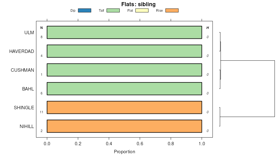
Zigweid-Bahl association, 0 to 6 percent slopes | 272 | 3088 | 1669760 | 1t1j7 | wy609 | 2006 | 1:24000 |
Zigweid-Cambria complex, 0 to 6 percent slopes | 273 | 2019 | 1669761 | 2yv7j | wy609 | 2006 | 1:24000 |
Zigweid-Theedle loams, 3 to 15 percent slopes | 274 | 581 | 1669762 | 2v09r | wy609 | 2006 | 1:24000 |
Cambria-Zigweid complex, 2 to 15 percent slopes | 117 | 63 | 1669665 | 2v09s | wy609 | 2006 | 1:24000 |
Zigweid loam, 2 to 9 percent slopes | 271 | 9 | 1669763 | 2wlrx | wy609 | 2006 | 1:24000 |
Zigweid-Bowbac-Bunkwater-like complex, 1 to 25 percent slopes | 5C13 | 1485 | 3358261 | 30zsv | wy617 | | 1:24000 |
Zigweid loam, 0 to 3 percent slopes | 67A | 393 | 3358311 | 53tj | wy617 | | 1:24000 |
Shingle-Badland-Zigweid complex, 4 to 20 percent slopes | 5C03 | 288 | 3197036 | 2zb03 | wy617 | | 1:24000 |
Zigweid-Huntsman-like-Stonebarn-like complex, 1 to 6 percent slopes, frequently flooded | 1108 | 242 | 3358279 | 2ypns | wy617 | | 1:24000 |
Zigweid loam, 3 to 6 percent slopes | 67B | 99 | 3358312 | 53tl | wy617 | | 1:24000 |
Zigweid loam, 6 to 15 percent slopes | 67C | 29 | 3302874 | 53tm | wy617 | | 1:24000 |
Shingle-Kishona-Zigweid loams, 6 to 30 percent slopes | SNc | 15427 | 350930 | 2yv74 | wy619 | 1971 | 1:24000 |
Cambria-Zigweid complex, 0 to 6 percent slopes | STg | 12551 | 350943 | 2yv7h | wy619 | 1971 | 1:24000 |
Kim-Zigweid association, gently sloping | KZB | 5399 | 350869 | cs3c | wy619 | 1971 | 1:24000 |
Zigweid-Keyner complex, hilly | ZKD | 3104 | 350969 | cs6l | wy619 | 1971 | 1:24000 |
Kim-Zigweid association, moderately steep | KZD | 2045 | 350870 | cs3d | wy619 | 1971 | 1:24000 |
Zigweid loam, 3 to 6 percent slopes | ZgB | 1927 | 350971 | cs6n | wy619 | 1971 | 1:24000 |
Zigweid loam, 0 to 3 percent slopes | ZgA | 1077 | 350970 | 2v09n | wy619 | 1971 | 1:24000 |
Cambria-Zigweid complex, 2 to 15 percent slopes | 142 | 44 | 816597 | 2v09s | wy619 | 1971 | 1:24000 |
Cambria-Kishona-Zigweid loams, 0 to 6 percent slopes | 116 | 28 | 816862 | 2v09t | wy619 | 1971 | 1:24000 |
Petrie-Zigweid complex, wet, 0 to 3 percent slopes | 235 | 26 | 816847 | wdzx | wy619 | 1971 | 1:24000 |
Forkwood-Zigweid complex, 3 to 15 percent slopes | 188 | 50146 | 502276 | 2wlrg | wy625 | 1985 | 1:24000 |
Zigweid-Theedle loams, 3 to 15 percent slopes | 311 | 36306 | 502459 | 2v09r | wy625 | 1985 | 1:24000 |
Cambria-Zigweid complex, 2 to 15 percent slopes | 142 | 33290 | 502221 | 2v09s | wy625 | 1985 | 1:24000 |
Zigweid loam, 2 to 9 percent slopes | 310 | 24567 | 502457 | 2wlrx | wy625 | 1985 | 1:24000 |
Cambria-Zigweid association, dry, sloping | 143 | 7179 | 502223 | jvlr | wy625 | 1985 | 1:24000 |
Petrie-Zigweid complex, wet, 0 to 3 percent slopes | 235 | 3825 | 502360 | jvr5 | wy625 | 1985 | 1:24000 |
Zigweid-Urban land complex, 2 to 8 percent slopes | 312 | 335 | 502461 | jvvf | wy625 | 1985 | 1:24000 |
Zigweid-Cambria-Theedle complex, 6 to 15 percent slopes | 319 | 175 | 1421355 | 2ztzf | wy625 | 1985 | 1:24000 |
Zigweid-Cambria complex, 0 to 6 percent slopes | 329 | 14 | 1426087 | 2yv7j | wy625 | 1985 | 1:24000 |
Zigweid loam, 6 to 15 percent slopes | 67C | 6747 | 152632 | 53tm | wy629 | | 1:24000 |
Zigweid-Shingle-Begay complex, 4 to 20 percent slopes | 5323 | 4712 | 2911970 | 2y4ys | wy629 | | 1:24000 |
Cambria-Zigweid complex, 1 to 6 percent slopes | 2131 | 3749 | 2911892 | 2w7j0 | wy629 | | 1:24000 |
Zigweid-Cushman complex, 8 to 35 percent slopes | 5408 | 1753 | 2911873 | 2w7hh | wy629 | | 1:24000 |
Hiland-like-Zigweid-Ulm complex 0 to 4 percent slopes | 1115 | 1711 | 2911878 | 2w7hm | wy629 | | 1:24000 |
Zigweid loam, 3 to 6 percent slopes | 67B | 801 | 152631 | 53tl | wy629 | | 1:24000 |
Vonid-Cascajo-Zigweid complex, 1 to 4 percent slopes | 1132 | 676 | 3206632 | 2zc4h | wy629 | | 1:24000 |
Larim-like-Zigweid-Taluce-like complex, 15 to 60 percent slopes | 5544 | 662 | 3203038 | 2zbqx | wy629 | | 1:24000 |
Zigweid loam, 0 to 3 percent slopes | 67A | 620 | 152629 | 53tj | wy629 | | 1:24000 |
Taluce, very bouldery-Zigweid complex, 15 to 50 percent slopes | 5820 | 342 | 3203139 | 2zy9x | wy629 | | 1:24000 |
Zigweid-Huntsman-like-Stonebarn-like complex, 1 to 6 percent slopes, frequently flooded | 1108 | 266 | 3136856 | 2ypns | wy629 | | 1:24000 |
Vonalee-like-Keeline-like, frequently flooded-Zigweid complex, 0 to 4 percent slopes | 1121 | 9 | 3133271 | 2ynmz | wy629 | | 1:24000 |
Kishona-Zigweid-Cambria loams, moist, 6 to 9 percent slopes | 320 | 27659 | 359321 | 2yryd | wy633 | 1987 | 1:24000 |
Kishona-Zigweid-Cambria complex, 6 to 15 percent slopes | 317 | 17710 | 361006 | 2wls0 | wy633 | 1987 | 1:24000 |
Kishona-Zigweid-Cambria complex, moist, 3 to 6 percent slopes | 319 | 11261 | 361004 | 2yryb | wy633 | 1987 | 1:24000 |
Kishona-Zigweid-Cambria complex, moist, 0 to 3 percent slopes | 318 | 7885 | 361005 | 2yry9 | wy633 | 1987 | 1:24000 |
Zigweid-Cambria loams, 0 to 6 percent slopes | 316 | 6429 | 361007 | d3nd | wy633 | 1987 | 1:24000 |
Zigweid loam, 0 to 3 percent slopes | 315 | 905 | 361008 | 2v09n | wy633 | 1987 | 1:24000 |
Zigweid loam, 6 to 15 percent slopes | 67C | 310 | 3253334 | 53tm | wy656 | 2008 | 1:24000 |
Kishona-Zigweid-Cambria complex, 6 to 15 percent slopes | 339 | 1319 | 817618 | 2wls0 | wy705 | 2003 | 1:24000 |
Zigweid-Cambria loams, 0 to 6 percent slopes | 338 | 775 | 817617 | wfsr | wy705 | 2003 | 1:24000 |
Zigweid-Cambria complex, 0 to 6 percent slopes | 151 | 12487 | 351529 | 2yv7j | wy709 | 1983 | 1:24000 |
Zigweid-Cambria-Theedle complex, 6 to 15 percent slopes | 152 | 11753 | 351530 | 2ztzf | wy709 | 1983 | 1:24000 |
Zigweid-Bahl association, 0 to 6 percent slopes | 150 | 6525 | 351528 | cssm | wy709 | 1983 | 1:24000 |
Forkwood-Zigweid complex, 3 to 15 percent slopes | 246 | 118 | 1427903 | 2wlrg | wy709 | 1983 | 1:24000 |
Zigweid-Theedle loams, 3 to 15 percent slopes | 249 | 29 | 1427906 | 2v09r | wy709 | 1983 | 1:24000 |
Kishona-Zigweid loams, 3 to 15 percent slopes, gullied | 734 | 1812 | 1473880 | 1lgpj | wy719 | 2013 | 1:24000 |