| Rock outcrop-Xerorthents association | Re | 14610 | 455848 | h9bs | ca013 | 1973 | 1:24000 |
Xerorthents-Millsholm complex, 50 to 75 percent slopes | 160aw | 2 | 843740 | x9zf | ca013 | 1973 | 1:24000 |
Xerorthents-Los Osos complex, 30 to 50 percent slopes | 158aw | 1 | 843739 | x9zd | ca013 | 1973 | 1:24000 |
Xerorthents-Urban land complex, 0 to 9 percent slopes | 204 | 10115 | 459496 | hf4g | ca041 | 1979 | 1:24000 |
Urban land-Xerorthents complex, 0 to 9 percent slopes | 202 | 3635 | 459494 | hf4d | ca041 | 1979 | 1:24000 |
Xerorthents, fill | 203 | 2440 | 459495 | hf4f | ca041 | 1979 | 1:24000 |
Rock outcrop-Xerorthents complex, 50 to 75 percent slopes | 159 | 1570 | 459451 | hf30 | ca041 | 1979 | 1:24000 |
Rock outcrop-Xerorthents association, 30 to 75 percent slopes | Rc | 129000 | 3251916 | 2zwr2 | ca053 | 1972 | 1:24000 |
Xerorthents, dissected | Xd | 16625 | 455754 | h97r | ca053 | 1972 | 1:24000 |
Xerorthents, loamy | Xc | 6790 | 455753 | h97q | ca053 | 1972 | 1:24000 |
Xerorthents, sandy | Xb | 3735 | 455752 | h97p | ca053 | 1972 | 1:24000 |
Xerorthents, dredge tailings, 2 to 50 percent slopes | 245 | 16568 | 461989 | hhqw | ca067 | 1989 | 1:24000 |
Xerorthents, dredge tailings-Urban land complex, 0 to 2 percent slopes | 246 | 3021 | 461990 | hhqx | ca067 | 1989 | 1:24000 |
Natomas-Xerorthents, dredge tailings complex, 0 to 50 percent slopes | 182 | 382 | 461926 | hhnv | ca067 | 1989 | 1:24000 |
Rock outcrop-Xerorthents association, 30 to 75 percent slopes | Rcmo | 16 | 3251930 | 2zwr2 | ca069 | 1965 | 1:20000 |
Xerorthents, dissected | Xdmo | 6 | 849251 | xhq6 | ca069 | 1965 | 1:20000 |
Xerofluvents-Xerorthents complex, 1 to 8 percent slopes, occasionally flooded | 278 | 2076 | 462170 | hhxq | ca077 | 1990 | 1:24000 |
Xerorthents-Rock outcrop complex, 50 to 100 percent slo pes* | 181 | 3260 | 455957 | h9g9 | ca087 | 1976 | 1:24000 |
Lava flows-Xerorthents complex, 0 to 50 percent slopes* | 176 | 5190 | 459085 | hdq6 | ca602 | 1978 | 1:24000 |
Rubble land-Xerorthents complex, 50 to 70 precent slopes | 305 | 1230 | 487199 | jbz3 | ca604 | 1994 | 1:24000 |
XERALFS-XERORTHENTS COMPLEX, 5 TO 50 PERCENT SLOPES | 213 | 1624 | 466117 | hn11 | ca606 | 1990 | 1:24000 |
XERORTHENTS-ROCK OUTCROP COMPLEX, 2 TO 15 PERCENT SLOPES | 218 | 369 | 466121 | hn15 | ca606 | 1990 | 1:24000 |
XERORTHENTS-ROCK OUTCROP COMPLEX, 15 TO 75 PERCENT SLOPES | 219 | 126 | 466122 | hn16 | ca606 | 1990 | 1:24000 |
Xerorthents-Los Osos complex, 30 to 50 percent slopes | 158 | 3429 | 456711 | hb7m | ca610 | 1975 | 1:24000 |
Xerorthents-Millsholm complex, 30 to 50 percent slopes | 159 | 3389 | 456712 | hb7n | ca610 | 1975 | 1:24000 |
Xerorthents-Altamont complex, 30 to 50 percent slopes | 157 | 1892 | 456710 | hb7l | ca610 | 1975 | 1:24000 |
Xerorthents-Millsholm complex, 50 to 75 percent slopes | 160 | 1441 | 456713 | hb7p | ca610 | 1975 | 1:24000 |
Xerorthents, clayey | 155 | 970 | 456708 | hb7j | ca610 | 1975 | 1:24000 |
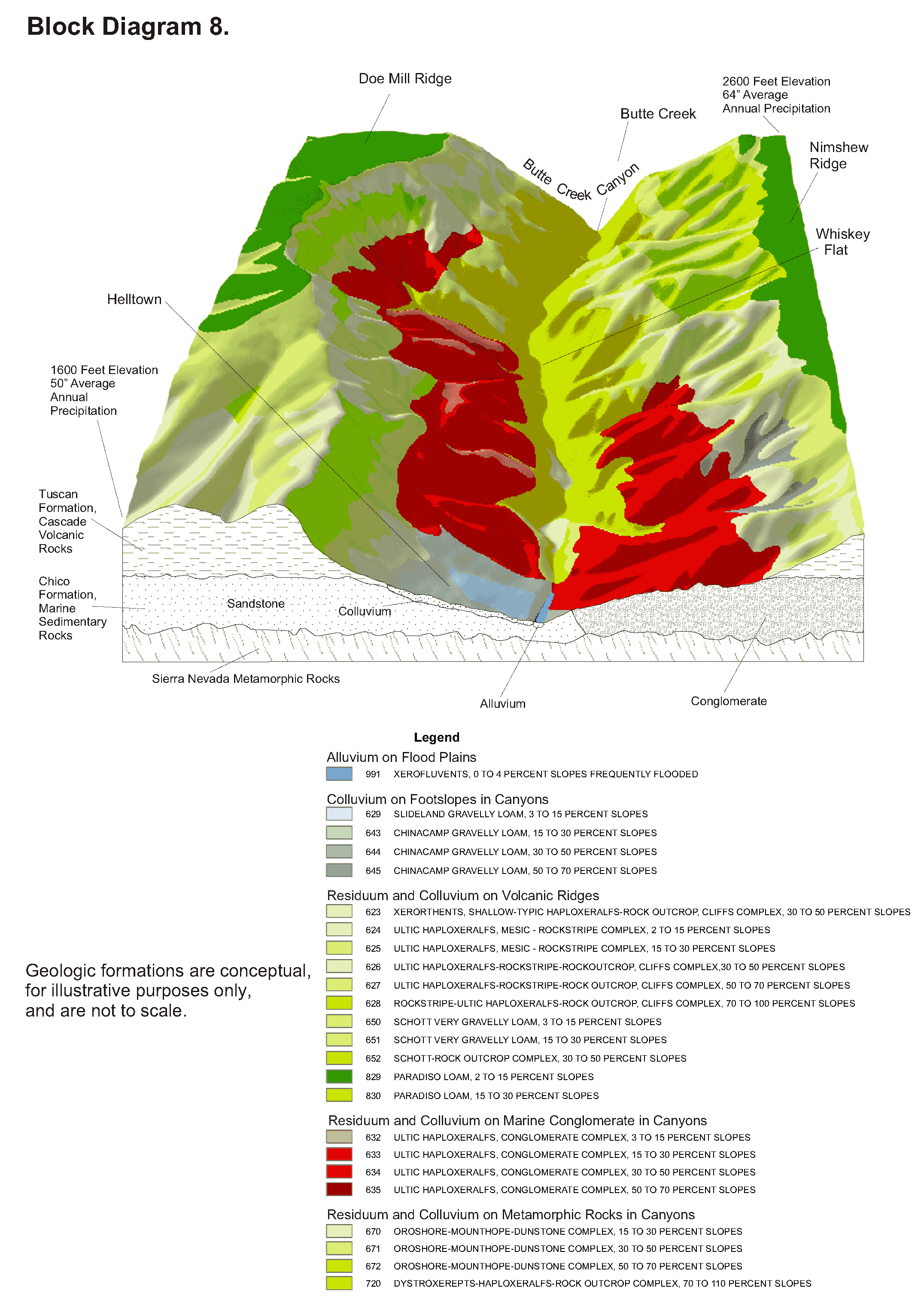
Xerorthents, shallow-Typic Haploxeralfs-Rock outcrop, cliffs complex, 30 to 50 percent slopes | 623 | 11972 | 461453 | hh5l | ca612 | 2005 | 1:24000 |
Xerorthents, shallow-Typic Haploxeralfs-Rock outrcrop, cliffs complex, 15 to 30 percent slopes | 622 | 11197 | 461454 | hh5m | ca612 | 2005 | 1:24000 |
Xerorthents, Tailings and 0 to 50 percent slopes | 118 | 10196 | 461205 | hgxl | ca612 | 2005 | 1:24000 |
Xerorthents, shallow-Typic Haploxeralfs complex, 2 to 15 percent slopes | 687 | 2226 | 824118 | wnkg | ca612 | 2005 | 1:24000 |
Xerorthents, tailings-Urban land complex, 0 to 2 percent slopes | 119 | 1906 | 727222 | sdqs | ca612 | 2005 | 1:24000 |
Xerorthents, placer areas | 197 | 4950 | 460361 | hg1c | ca620 | 1975 | 1:24000 |
Xerorthents, cut and fill areas | 196 | 4300 | 460360 | hg1b | ca620 | 1975 | 1:24000 |
Xerorthents, trash substratum, 0 to 2 percent slopes | 110 | 631 | 1543357 | 1nszq | ca641 | 2009 | 1:24000 |
Xerorthents, trash substratum 15 to 30 percent slopes | 112 | 320 | 1602803 | 1qsvb | ca641 | 2009 | 1:24000 |
Urban Land-Xerorthents, anthropogenic fill complex, 0 to 2 percent slopes | 123 | 298 | 2391353 | 2l8df | ca641 | 2009 | 1:24000 |
Xerorthents, trash substratum, 9 to 15 percent slopes | 111 | 116 | 1543356 | 1nszp | ca641 | 2009 | 1:24000 |
Xerorthents, anthropogenic fill, 0 to 2 percent slopes | 122 | 57 | 1602807 | 1qsvg | ca641 | 2009 | 1:24000 |
Xerorthents, trash substratum, 30 to 50 percent slopes | 113 | 19 | 1602804 | 1qsvc | ca641 | 2009 | 1:24000 |
Xerofluvents-Xerorthents complex, 1 to 8 percent slopes, occasionally flooded | 220 | 2165 | 466942 | hnwn | ca642 | 1998 | 1:24000 |
Xerorthents, shallow-Typic Haploxeralfs-Rock outcrop, cliffs complex, 30 to 50 percent slopes | 623bu | 360 | 2766050 | hh5l | ca645 | 1961 | 1:20000 |
Xerorthents, shallow-Typic Haploxeralfs-Rock outrcrop, cliffs complex, 15 to 30 percent slopes | 622bu | 176 | 2766051 | hh5m | ca645 | 1961 | 1:20000 |
Xerorthents, escarpment | 223 | 1928 | 457195 | hbr7 | ca664 | 1977 | 1:24000 |
Xerorthents, eroded | 222 | 1000 | 457194 | hbr6 | ca664 | 1977 | 1:24000 |
Xerorthents, very gravelly, 50 to 75 percent slopes | 250 | 533 | 463795 | hkm4 | ca666 | 1983 | 1:24000 |
Xerorthents-Badland complex, 30 to 75 percent slopes | 219 | 6890 | 458457 | hd1y | ca667 | 2003 | 1:24000 |
Godde-Xerorthents-Rock outcrop complex, 30 to 75 percent slopes | 401 | 4430 | 458505 | hd3h | ca667 | 2003 | 1:24000 |
Muranch-Xerorthents-Rock outcrop association, 30 to 75 percent slopes | 380 | 3875 | 458502 | hd3d | ca667 | 2003 | 1:24000 |
Bellyspring-Xerorthents-Panoza complex 15 to 50 percent slopes | 445 | 2330 | 458513 | hd3r | ca667 | 2003 | 1:24000 |
Xerorthents very gravelly, 50 to 75 percent slopes | 908 | 185 | 458523 | hd42 | ca667 | 2003 | 1:24000 |
Xerorthents-Rock outcrop complex, 30 to 75 percent slopes | 311 | 204 | 467467 | hpfl | ca668 | 2007 | 1:24000 |
Xerorthents-Rock outcrop complex, very steep | 211 | 23721 | 463915 | hkr0 | ca670 | 1977 | 1:24000 |
Xerorthents, very steep | 209 | 7270 | 463913 | hkqy | ca670 | 1977 | 1:24000 |
Xerorthents, loamy, very steep | 210 | 1788 | 463914 | hkqz | ca670 | 1977 | 1:24000 |
Xerorthents, cut and fill areas | XA | 909 | 457646 | hc6s | ca673 | 1974 | 1:24000 |
Xerorthents, cut and fill areas | XA | 55 | 725828 | sc8t | ca674 | 1968 | 1:24000 |
Urban land-Balcom-Xerorthents, landscaped complex, 10 to 60 percent slopes | 1249LA | | 2911687 | 2sthx | ca676 | 1975 | 1:24000 |
Xerorthents-Urban land-Balcom complex, 5 to 15 percent slopes | 139 | 7095 | 456041 | h9k0 | ca676 | 1975 | 1:24000 |
Xerorthents-Urban land-Balcom complex, 15 to 30 percent slopes | 140 | 2946 | 456042 | h9k1 | ca676 | 1975 | 1:24000 |
Xerorthents-Urban land-Saugus complex, 15 to 30 percent slopes | 143 | 810 | 456045 | h9k4 | ca676 | 1975 | 1:24000 |
Xerorthents-Urban land-Balcom complex, 0 to 15 percent slopes | 531 | 575 | 735089 | snxk | ca676 | 1975 | 1:24000 |
Xerorthents, 0 to 30 percent slopes | 138 | 550 | 456040 | h9jz | ca676 | 1975 | 1:24000 |
Xerorthents-Urban land-Gazos complex, 15 to 30 percent slopes | 142 | 550 | 456044 | h9k3 | ca676 | 1975 | 1:24000 |
Xerorthents-Urban land-Gazos complex, 5 to 15 percent slopes | 141 | 235 | 456043 | h9k2 | ca676 | 1975 | 1:24000 |
Urban land-Xerorthents-Friant complex, 15 to 30 percent slopes | 136 | 225 | 456038 | h9jx | ca676 | 1975 | 1:24000 |
Xerorthents-Urban land-Gazos complex, 0 to 30 percent slopes | 532 | 40 | 735090 | snxl | ca676 | 1975 | 1:24000 |
Xerorthents-Urban land-Balcom complex, 0 to 30 percent slopes | 530 | 35 | 735088 | snxj | ca676 | 1975 | 1:24000 |
Xerorthents, landscaped, 0 to 9 percent slopes | 160 | 1 | 735078 | snx6 | ca676 | 1975 | 1:24000 |
Xerorthents loamy, cut and fill areas, 9 to 15 percent slopes | 219 | 1095 | 458120 | hcq2 | ca678 | 1974 | 1:24000 |
Urban land-Xerorthents, landscaped, association 0 to 8 percent slopes | 450 | 93 | 2393476 | 2lblx | ca688 | 2008 | 1:24000 |
Gorman-Typic Xerorthents, mesic-Xerorthents, shallow, complex, 30 to 100 percent slopes | 590 | 4640 | 466567 | hnhk | ca691 | 2008 | 1:24000 |
Calcic Haploxerepts-Calcic Pachic Argixerolls, fine-Xerorthents, shallow, complex, 30 to 75 percent slopes | 398 | 3953 | 466588 | hnj7 | ca691 | 2008 | 1:24000 |
Calcic Haploxerepts-Xerorthents, shallow-Badland complex, 30 to 100 percent slopes | 955 | 3662 | 628327 | p2tm | ca691 | 2008 | 1:24000 |
Typic Xerorthents, mesic-Haploxerepts-Xerorthents, sandy, association, 30 to 75 percent slopes | 620 | 1548 | 628253 | p2r7 | ca691 | 2008 | 1:24000 |
Xerorthents-Badland complex, 30 to 75 percent slopes | 219 | 345 | 2389936 | 2l6xq | ca691 | 2008 | 1:24000 |
Urban land-Balcom-Xerorthents, landscaped complex, 10 to 60 percent slopes | 1249LA | | 2911675 | 2sthx | ca692 | 2001 | 1:24000 |
Urban land-Montebello-Xerorthents complex, 0 to 15 percent slopes, terraced | 1210LA | | 2911749 | 2qdsh | ca692 | 2001 | 1:24000 |
Urban land-Xerorthents, landscaped complex, 0 to 5 percent slopes | 250 | 12485 | 469980 | hs1n | ca692 | 2001 | 1:24000 |
Xerorthents-Urban land-Balcom complex, 0 to 15 percent slopes | 531 | 2520 | 470000 | hs29 | ca692 | 2001 | 1:24000 |
Urban land-Xerorthents, landscaped, complex, rarely flooded, 0 to 5 percent slopes | 252 | 1147 | 605059 | n9m1 | ca692 | 2001 | 1:24000 |
Xerorthents, landscaped, 0 to 9 percent slopes | 160 | 965 | 469951 | hs0q | ca692 | 2001 | 1:24000 |
Cropley, coastal-Xerorthents, landscaped-Urban land complex, 0 to 9 percent slopes | 434 | 870 | 614674 | nmm6 | ca692 | 2001 | 1:24000 |
Xerorthents-Urban land-Pachic Argixerolls, gullied complex, 0 to 30 percent slopes | 532 | 140 | 470001 | hs2b | ca692 | 2001 | 1:24000 |
Xerorthents-Urban land-Balcom complex, 0 to 30 percent slopes | 530 | 140 | 469999 | hs28 | ca692 | 2001 | 1:24000 |
Urban land-Montebello-Xerorthents complex, 0 to 15 percent slopes, terraced | 1210 | 6703 | 2562670 | 2qdsh | ca696 | 2016 | 1:24000 |
Urban land-Xerorthents-Osito complex, 10 to 35 percent slopes | 1163 | 3059 | 2747754 | 2sx6h | ca696 | 2016 | 1:24000 |
Urban land-Xerorthents, terraced-Centinela complex, 2 to 9 percent slopes | 1139 | 1868 | 2513717 | 2pt43 | ca696 | 2016 | 1:24000 |
Urban land-Balcom-Xerorthents, landscaped complex, 10 to 60 percent slopes | 1249 | 1365 | 2747693 | 2sthx | ca696 | 2016 | 1:24000 |
Urban land-Aquic Xerorthents-Xerorthents, dredged spoil complex, 0 to 2 percent slopes | 1103 | 1223 | 2451256 | 2n8qs | ca696 | 2016 | 1:24000 |
Urban land-Xerorthents, landscaped complex, 0 to 5 percent slopes | 250sm | 499 | 2747756 | hs1n | ca696 | 2016 | 1:24000 |
Urban land-Xerorthents, landscaped, complex, rarely flooded, 0 to 5 percent slopes | 252sm | 188 | 2911680 | n9m1 | ca696 | 2016 | 1:24000 |
Lava flows-Xerorthents complex, 0 to 50 percent slopes* | 176sc | 214 | 1905921 | 21z8b | ca702 | 1984 | 1:24000 |
Xeralfs-Xerorthents complex, 5 to 50 percent slopes | 213tw | 282 | 1868852 | 20qpk | ca707 | 1983 | 1:24000 |
Xerorthents-Rock outcrop complex, 2 to 15 percent slopes | 218tw | 11 | 1868856 | 20qpp | ca707 | 1983 | 1:24000 |
Xerorthents, cut and fill areas | 196pc | 12 | 1585956 | 1q79w | ca719 | 1982 | 1:24000 |
Xerofluvents-Xerorthents-Riverwash association, sloping | 300 | 9839 | 465175 | hm1n | ca760 | 1981 | 1:24000 |
Rock outcrop-Xerorthents association, steep | 404 | 1680 | 465184 | hm1y | ca760 | 1981 | 1:24000 |
Xerofluvents-Xerorthents association, sloping | 301 | 1064 | 465176 | hm1p | ca760 | 1981 | 1:24000 |
Xerofluvents-Xerorthents-Riverwash complex, 0 to 15 percent slopes | 50 | 3724 | 465319 | hm69 | ca772 | 1981 | 1:24000 |
Urban land-Montebello-Xerorthents complex, 0 to 15 percent slopes, terraced | 1210LA | | 2911696 | 2qdsh | ca776 | 1981 | 1:24000 |
Pacifico family-Xerothents complex, 50 to 90 percent slopes | 57 | 8000 | 465358 | hm7k | ca776 | 1981 | 1:24000 |
Green Bluff-Hohmann families-Xerorthents complex, 15 to 60 percent slopes | 406 | 4720 | 465349 | hm78 | ca776 | 1981 | 1:24000 |
Xerorthents-Green Bluff family-Rock outcrop complex, 15 to 50 percent slopes | 405 | 4310 | 465348 | hm77 | ca776 | 1981 | 1:24000 |
Balder family-Xerorthents complex, 5 to 60 percent slopes | 640 | 3833 | 465370 | hm7y | ca776 | 1981 | 1:24000 |
Mollic Haploxeralfs, cool-Xerorthents, dry-Green Bluff family, dry association, 5 to 60 percent slopes | 634 | 3231 | 465368 | hm7w | ca776 | 1981 | 1:24000 |
Balder family-Xerorthents complex, 5 to 60 percent slopes | 640 | 691 | 1380273 | 1hb8y | ca777 | 1981 | 1:24000 |
Rock outcrop-Xerorthents complex, very steep | 108 | 25173 | 80171 | 2pf5 | id704 | 1992 | 1:24000 |
Xerochrepts-Wormcreek-Xerorthents complex, 20 to 70 percent slopes | 159 | 3285 | 485252 | j8y9 | id714 | 1997 | 1:24000 |
Preston-Xerorthents complex, 35 to 60 percent slopes | 126 | 1716 | 485216 | j8x4 | id714 | 1997 | 1:24000 |
Xerorthents, 30 to 60 percent slopes | 160 | 1145 | 485254 | j8yc | id714 | 1997 | 1:24000 |
Haploxerolls-Xerorthents complex, 20 to 60 percent slopes | 48 | 1095 | 485293 | j8zm | id714 | 1997 | 1:24000 |
Lostbasin-Xerorthents-Rock outcrop complex, 35 to 50 percent south slopes | 101E | 19957 | 62059 | 22kx | or604 | 1988 | 1:24000 |
Rock outcrop-Lostbasin-Xerorthents complex, 50 to 80 percent south slopes | 134F | 5158 | 62103 | 22mb | or604 | 1988 | 1:24000 |
Xerorthents, landfill | 170 | 8 | 63530 | 243c | or620 | 1992 | 1:24000 |
Xerorthents-Dumps complex, 0 to 15 percent slopes | 208C | 2256 | 469701 | hrrn | or632 | 1989 | 1:20000 |
Fluventic Haploxerolls-Xerorthents complex, 1 to 2 percent slopes | 6002 | 322 | 3439456 | 2z9py | or637 | 1981 | 1:20000 |
Xerorthents-Rock outcrop complex, 30 to 80 percent slopes | 273G | 479 | 66741 | 27fy | or649 | 1994 | 1:24000 |
Fluventic Haploxerolls-Xerorthents complex, 1 to 2 percent slopes | 6002 | 3849 | 3385536 | 2z9py | or657 | | 1:24000 |
Xerorthents, 50 to 90 percent slopes | 254 | 990 | 72381 | 2f9w | wa015 | 1994 | 1:24000 |
Beaches-Endoaquents, tidal-Xerorthents association, 0 to 5 percent slopes | 1025 | 3135 | 2230264 | 2dvs0 | wa029 | 2009 | 1:12000 |
Xerorthents-Endoaquents, tidal association, 0 to 100 percent slopes | 3008 | 576 | 2375402 | 2kqsw | wa029 | 2009 | 1:12000 |
Beaches-Endoaquents, tidal-Xerorthents association, 0 to 5 percent slopes | 1014 | 2383 | 1151905 | 17nn7 | wa055 | 2006 | 1:12000 |
Xerorthents-Endoaquents, tidal association, 0 to 100 percent slopes | 3008 | 87 | 1151880 | 17nmf | wa055 | 2006 | 1:12000 |
Xerorthents, 0 to 15 percent slopes | 9994 | 541 | 3015868 | 2w951 | wa627 | 1979 | 1:24000 |
Xerorthents-Endoaquents, tidal association, 0 to 100 percent slopes | 3008 | 36 | 3350236 | 17nmf | wa635 | 1977 | 1:24000 |
Beaches-Endoaquents, tidal-Xerorthents association, 0 to 5 percent slopes | 1025 | 10 | 3350239 | 2dvs0 | wa635 | 1977 | 1:24000 |
Urban land-Xerorthents complex, 0 to 8 percent slopes | 9902 | | 3442399 | 2w95h | wa641 | 1980 | 1:24000 |
Xerorthents, steep | 248 | 8404 | 74408 | 2hf8 | wa641 | 1980 | 1:24000 |
Xerorthents, spoils | 247 | 2377 | 74407 | 2hf7 | wa641 | 1980 | 1:24000 |
Xerorthents, 0 to 15 percent slopes | 9994 | 87 | 3015888 | 2w951 | wa641 | 1980 | 1:24000 |
Xerorthents-Endoaquents, tidal association, 0 to 100 percent slopes | 3008 | 135 | 3242067 | 17nmf | wa653 | 1974 | 1:24000 |
Beaches-Endoaquents, tidal-Xerorthents association, 0 to 5 percent slopes | 1025 | 10 | 3242041 | 2dvs0 | wa653 | 1974 | 1:24000 |
Xerorthents, 30 to 100 percent slopes | 3103 | 7 | 2651393 | 2nd04 | wa653 | 1974 | 1:24000 |
Xerorthents, 0 to 5 percent slopes | 165 | 1830 | 74799 | 2htw | wa657 | 1981 | 1:24000 |
Xerorthents-Rock outcrop complex, 50 to 90 percent slopes | 161 | 3109 | 1385532 | 1hhrl | wa659 | 1987 | 1:24000 |
Rock outcrop-Xerorthents complex, 50 to 90 percent slopes | 93 | 2456 | 1385620 | 1hhvf | wa659 | 1987 | 1:24000 |
Xerorthents, nearly level | 82 | 953 | 74972 | 2j0g | wa661 | 1979 | 1:24000 |
Beaches-Endoaquents, tidal-Xerorthents association, 0 to 5 percent slopes | 1025 | 281 | 2427640 | 2mh4z | wa661 | 1979 | 1:24000 |
Xerorthents, 0 to 5 percent slopes | 125 | 933 | 2454649 | 2nd87 | wa667 | 1983 | 1:24000 |
Xerorthents, 30 to 100 percent slopes | 3103 | 186 | 2651404 | 2nd04 | wa667 | 1983 | 1:24000 |
Beaches-Endoaquents, tidal-Xerorthents association, 0 to 5 percent slopes | 1025 | 164 | 3058031 | 2dvs0 | wa775 | 2019 | 1:12000 |
Beaches-Endoaquents, tidal-Xerorthents association, 0 to 5 percent slopes | 1025 | 27 | 3227030 | 2dvs0 | wa776 | 2021 | 1:24000 |
Xerorthents, 30 to 100 percent slopes | 3103 | 1949 | 2493120 | 2nd04 | wa777 | 2012 | 1:24000 |
Xerorthents-Endoaquents, tidal association, 0 to 100 percent slopes | 3008 | 36 | 3346837 | 17nmf | wa778 | 2022 | 1:12000 |