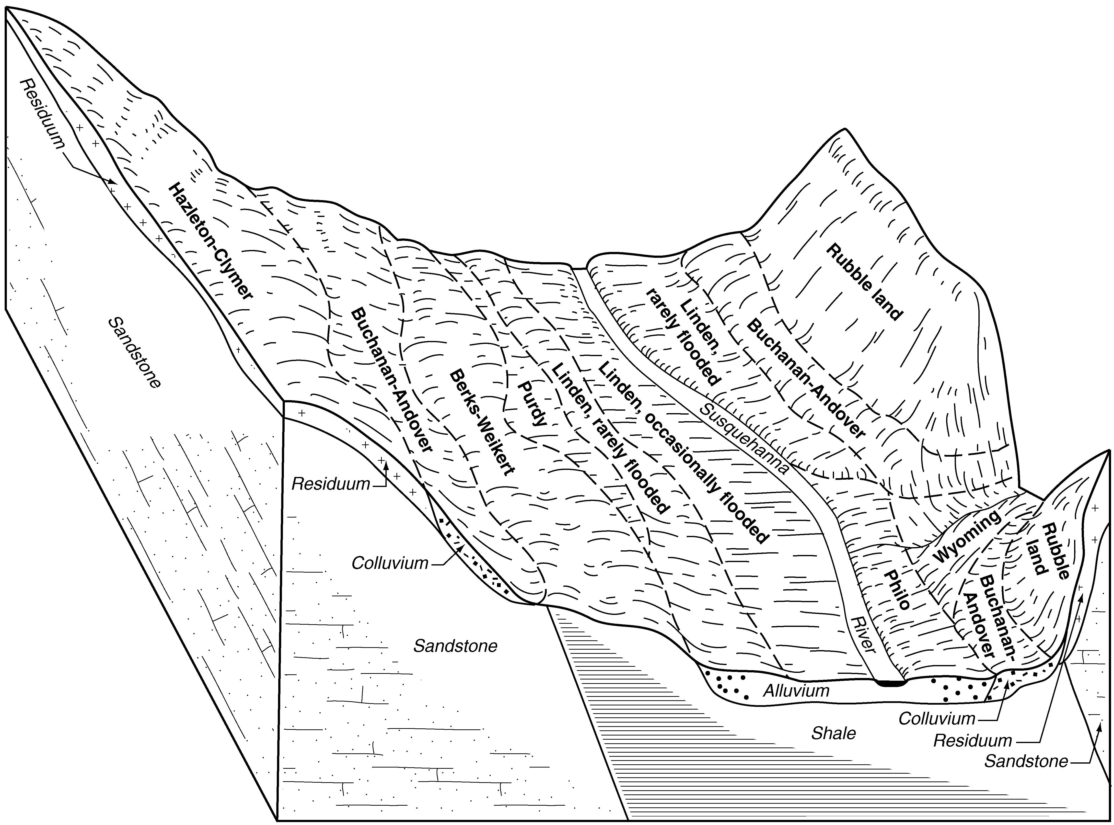
| Wyoming gravelly sandy loam, rarely flooded, 0 to 5 percent slopes | WyA | 1119 | 538361 | l26h | pa027 | 1975 | 1:20000 |
Wyoming very gravelly loam, 0 to 3 percent slopes | WyA | 2275 | 544136 | l86s | pa035 | 2002 | 1:24000 |
Wyoming very gravelly loam, 3 to 8 percent slopes | WyB | 857 | 544137 | l86t | pa035 | 2002 | 1:24000 |
Wyoming gravelly sandy loam, 3 to 8 percent | WyB | 5055 | 296208 | 9y73 | pa039 | 1973 | 1:20000 |
Wyoming gravelly sandy loam, 8 to 15 percent slopes | WyC | 4177 | 296209 | 9y74 | pa039 | 1973 | 1:20000 |
Wyoming gravelly sandy loam, 15 to 25 percent slopes | WyD | 2752 | 296210 | 9y75 | pa039 | 1973 | 1:20000 |
Wyoming gravelly sandy loam, 0 to 3 percent slopes | WyA | 1514 | 296207 | 9y72 | pa039 | 1973 | 1:20000 |
Wyoming gravelly sandy loam, 3 to 8 percent slopes | WyB | 1642 | 299367 | b1j0 | pa069 | 1976 | 1:20000 |
Wyoming gravelly sandy loam, 8 to 15 percent slopes | WyC | 793 | 299368 | b1j1 | pa069 | 1976 | 1:20000 |
Wyoming gravelly sandy loam, 15 to 25 percent slopes | WyD | 684 | 299369 | b1j2 | pa069 | 1976 | 1:20000 |
Wyoming gravelly sandy loam, 0 to 3 percent slopes | WyA | 428 | 299366 | b1hz | pa069 | 1976 | 1:20000 |
Wyoming gravelly sandy loam, 25 to 45 percent slopes | WyE | 255 | 299370 | b1j3 | pa069 | 1976 | 1:20000 |
Wyoming gravelly loam, 15 to 25 percent slopes | WyD | 2785 | 296505 | 9yjp | pa079 | 1974 | 1:20000 |
Wyoming gravelly loam, 25 to 60 percent slopes | WyF | 2527 | 296506 | 9yjq | pa079 | 1974 | 1:20000 |
Wyoming gravelly sandy loam, occasionally flooded | Wy | 2581 | 539147 | l30v | pa081 | 1981 | 1:20000 |
Wyoming gravelly sandy loam, 8 to 15 percent slopes | WyC | 5154 | 296387 | 9ydw | pa089 | 1975 | 1:20000 |
Wyoming gravelly sandy loam, 3 to 8 percent slopes | WyB | 4092 | 296386 | 9ydv | pa089 | 1975 | 1:20000 |
Wyoming gravelly sandy loam, 25 to 70 percent slopes | WyE | 2356 | 296389 | 9ydy | pa089 | 1975 | 1:20000 |
Wyoming gravelly sandy loam, 15 to 25 percent slopes | WyD | 1989 | 296388 | 9ydx | pa089 | 1975 | 1:20000 |
Wyoming gravelly sandy loam, 0 to 3 percent slopes | WyA | 1913 | 296385 | 9ydt | pa089 | 1975 | 1:20000 |
Craigsville-Wyoming complex, 0 to 8 percent slopes, extremely stony | 9B | 24 | 296393 | 9yf2 | pa089 | 1975 | 1:20000 |
Wyoming gravelly sandy loam, 0 to 3 percent slopes | WyA | 66 | 539038 | l2xb | pa093 | 1980 | 1:20000 |
Wyoming gravelly sandy loam, 3 to 8 percent slopes | WyB | 39 | 539039 | l2xc | pa093 | 1980 | 1:20000 |
Wyoming gravelly sandy loam, 0 to 3 percent slopes | WyA | 632 | 539687 | l3l8 | pa097 | 1980 | 1:20000 |
Wyoming gravelly sandy loam, 3 to 8 percent slopes | WyB | 500 | 539688 | l3l9 | pa097 | 1980 | 1:20000 |
Wyoming very cobbly sandy loam, 3 to 8 percent slopes | 442B | 3323 | 297229 | 9z91 | pa103 | 1995 | 1:24000 |
Craigsville-Wyoming complex, 0 to 8 percent slopes, extremely stony | 9B | 1901 | 297253 | 9z9t | pa103 | 1995 | 1:24000 |
Wyoming and Chenango soils, 0 to 8 percent slopes | 108B | 1694 | 297183 | 9z7k | pa103 | 1995 | 1:24000 |
Wyoming very cobbly sandy loam, 8 to 15 percent slopes | 442C | 1408 | 297230 | 9z92 | pa103 | 1995 | 1:24000 |
Wyoming very cobbly sandy loam, 15 to 30 percent slopes | 442D | 575 | 297231 | 9z93 | pa103 | 1995 | 1:24000 |
Wyoming and Chenango soils, 8 to 15 percent slopes | 108C | 402 | 297184 | 9z7l | pa103 | 1995 | 1:24000 |
Terrace escarpments | Te | 438 | 297076 | 9z43 | pa115 | 1968 | 1:20000 |
Craigsville-Wyoming complex, 0 to 8 percent slopes, extremely stony | 9B | 15 | 319823 | bqsw | pa115 | 1968 | 1:20000 |
Wyoming gravelly sandy loam, 3 to 8 percent slopes | WyB | 11 | 319949 | bqxy | pa115 | 1968 | 1:20000 |
Wyoming gravelly loam, flooded | Wz | 2845 | 297182 | 9z7j | pa117 | 1973 | 1:20000 |
Wyoming gravelly sandy loam, 30 to 50 percent slopes | WyF | 2156 | 297181 | 9z7h | pa117 | 1973 | 1:20000 |
Wyoming gravelly sandy loam, 20 to 30 percent slopes | WyD | 1041 | 297180 | 9z7g | pa117 | 1973 | 1:20000 |
Wyoming gravelly sandy loam, 12 to 20 percent slopes | WyC | 1000 | 297179 | 9z7f | pa117 | 1973 | 1:20000 |
Wyoming gravelly sandy loam, 3 to 8 percent slopes | WyB | 93 | 540962 | l4xd | pa119 | 1980 | 1:20000 |
Wyoming gravelly sandy loam, 8 to 15 percent slopes | WyC | 2318 | 296641 | 9yp2 | pa127 | 1977 | 1:20000 |
Wyoming gravelly sandy loam, 3 to 8 percent slopes | WyB | 1716 | 296640 | 9yp1 | pa127 | 1977 | 1:20000 |
Wyoming gravelly sandy loam, 15 to 25 percent slopes | WyD | 1123 | 296642 | 9yp3 | pa127 | 1977 | 1:20000 |
Wyoming gravelly sandy loam, 25 to 45 percent slopes | WyE | 356 | 296643 | 9yp4 | pa127 | 1977 | 1:20000 |
Craigsville-Wyoming complex, 0 to 8 percent slopes, extremely stony | 9B | 41 | 319874 | bqvj | pa127 | 1977 | 1:20000 |
Wyoming gravelly sandy loam, 3 to 8 percent slopes | WyB | 3479 | 301996 | b47t | pa131 | 1976 | 1:20000 |
Wyoming gravelly sandy loam, 8 to 15 percent slopes | WyC | 2134 | 301997 | b47v | pa131 | 1976 | 1:20000 |
Wyoming gravelly sandy loam, 15 to 25 percent slopes | WyD | 1780 | 301998 | b47w | pa131 | 1976 | 1:20000 |
Wyoming gravelly sandy loam, 0 to 3 percent slopes | WyA | 1596 | 301995 | b47s | pa131 | 1976 | 1:20000 |
Wyoming gravelly sandy loam, 25 to 45 percent slopes | WyE | 1266 | 301999 | b47x | pa131 | 1976 | 1:20000 |
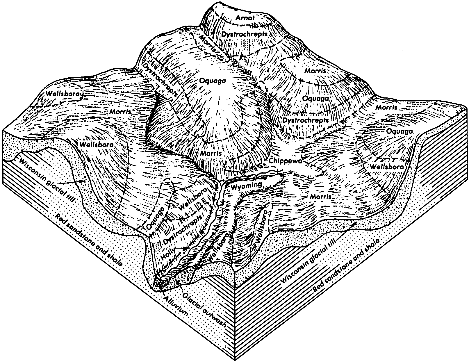
Wyoming gravelly sandy loam, 15 to 25 percent slopes | WmD | 2167 | 296799 | 9yv5 | pa610 | 1978 | 1:20000 |
Wyoming gravelly sandy loam, 8 to 15 percent slopes | WmC | 2152 | 296798 | 9yv4 | pa610 | 1978 | 1:20000 |
Wyoming gravelly sandy loam, 25 to 45 percent slopes | WmF | 1808 | 296800 | 9yv6 | pa610 | 1978 | 1:20000 |
Wyoming very stony sandy loam, 3 to 15 percent slopes | WoC | 1717 | 296801 | 9yv7 | pa610 | 1978 | 1:20000 |
Wyoming gravelly sandy loam, 3 to 8 percent slopes | WmB | 1197 | 296797 | 9yv3 | pa610 | 1978 | 1:20000 |