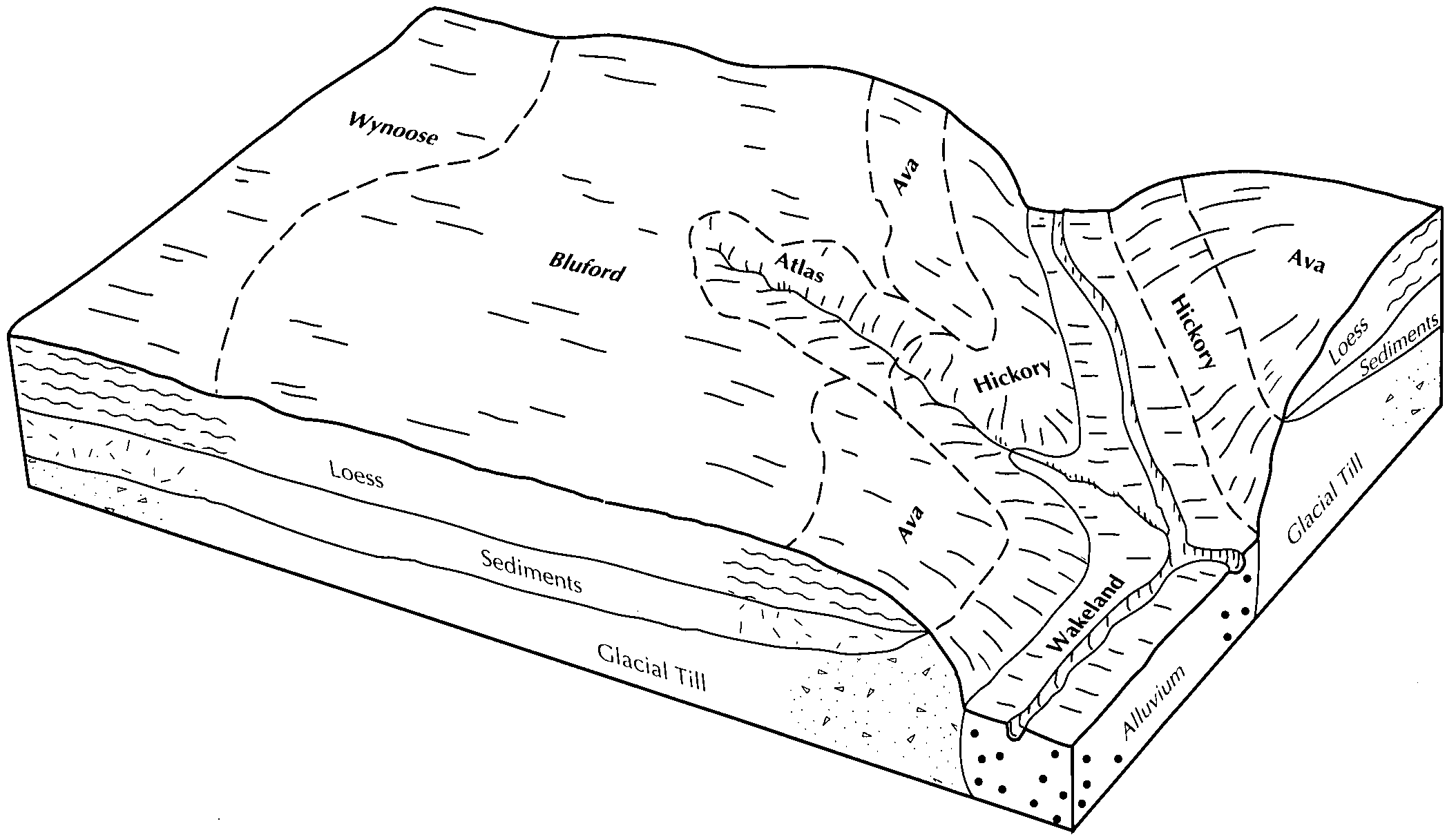
| Wynoose silt loam, 0 to 2 percent slopes | 12A | 362 | 173836 | 2t959 | il005 | 1981 | 1:12000 |
Wynoose silt loam, 0 to 2 percent slopes | 12A | 8121 | 1452519 | 2t959 | il023 | 2006 | 1:12000 |
Wynoose silt loam, 0 to 2 percent slopes | 12A | 26488 | 2109181 | 2t959 | il025 | 1993 | 1:12000 |
Wynoose silt loam, 0 to 2 percent slopes | 12A | 2540 | 174635 | 2t959 | il027 | 1992 | 1:15840 |
Wynoose silt loam, 0 to 2 percent slopes | 12A | 20351 | 166429 | 2t959 | il033 | 2004 | 1:12000 |
Wynoose silt loam, 0 to 2 percent slopes | 12A | 40518 | 174784 | 2t959 | il035 | 1992 | 1:15840 |
Wynoose-Huey complex | 896 | 3594 | 174871 | 5vz0 | il035 | 1992 | 1:15840 |
Wynoose silt loam, 0 to 2 percent slopes | 12A | 2435 | 175412 | 2t959 | il047 | 1967 | 1:15840 |
Wynoose silt loam, bench, 0 to 2 percent slopes | 639A | 1971 | 3210957 | 2t95n | il047 | 1967 | 1:15840 |
Wynoose silt loam, 0 to 2 percent slopes | 12A | 7925 | 173429 | 2t959 | il049 | 1986 | 1:15840 |
Wynoose silt loam, 0 to 2 percent slopes | 12A | 8327 | 173367 | 2t959 | il051 | 1991 | 1:15840 |
Wynoose silt loam, 0 to 2 percent slopes | 12A | 8173 | 807860 | 2t959 | il055 | 2005 | 1:12000 |
Wynoose silt loam, bench, 0 to 2 percent slopes | 639A | 6940 | 809225 | 2t95n | il055 | 2005 | 1:12000 |
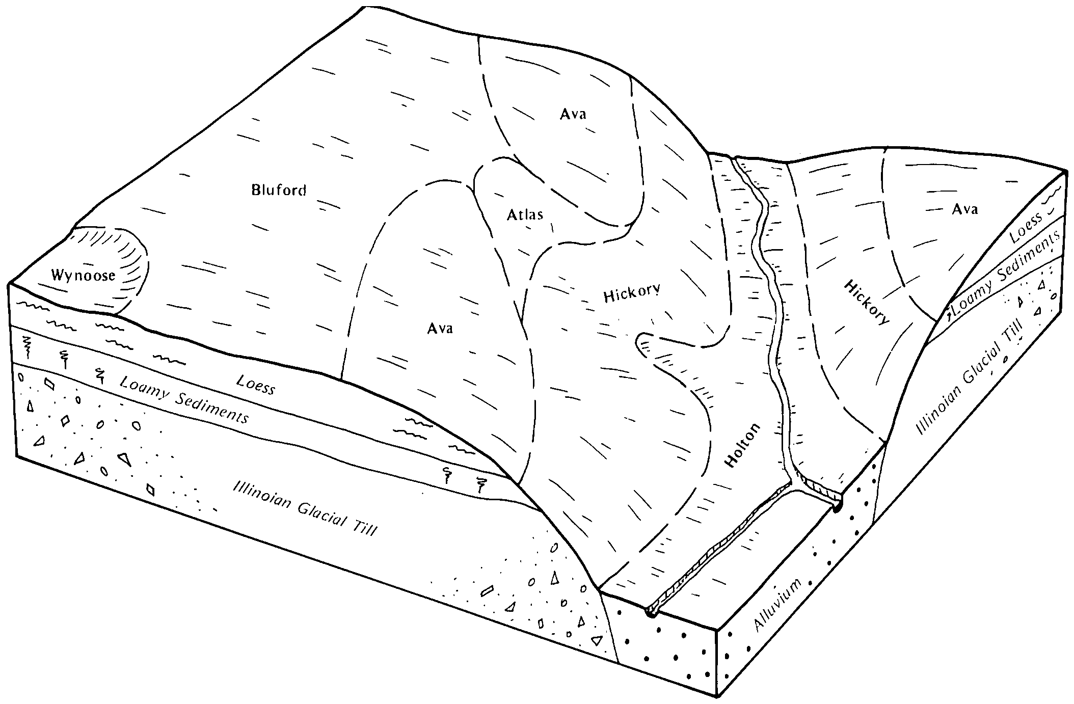
Wynoose silt loam, 0 to 2 percent slopes | 12A | 231 | 211584 | 2t959 | il059 | 1966 | 1:20000 |
Wynoose silt loam, bench, 0 to 2 percent slopes | 639A | 17 | 3164689 | 2t95n | il059 | 1966 | 1:20000 |
Wynoose silt loam, bench, 0 to 2 percent slopes | 639A | 6217 | 3164695 | 2t95n | il065 | 1982 | 1:15840 |
Wynoose silt loam, 0 to 2 percent slopes | 12A | 2540 | 175116 | 2t959 | il065 | 1982 | 1:15840 |
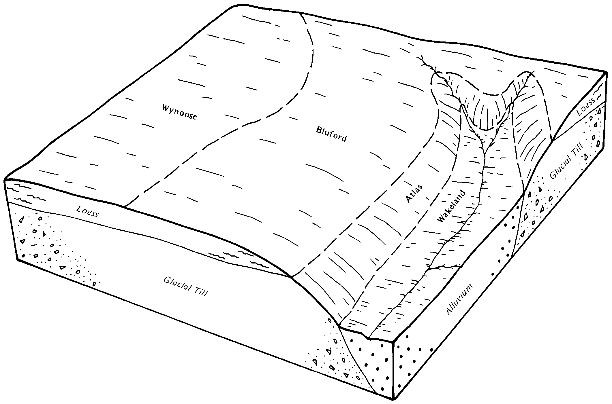
Wynoose silt loam, 0 to 2 percent slopes | 12A | 2395 | 1537808 | 2t959 | il077 | 2006 | 1:12000 |
Wynoose silt loam, bench, 0 to 2 percent slopes | 639A | 741 | 3272687 | 2t95n | il077 | 2006 | 1:12000 |
Wynoose silt loam, 0 to 2 percent slopes | 12A | 22644 | 1444931 | 2t959 | il079 | 2005 | 1:12000 |
Wynoose silt loam, 0 to 2 percent slopes | 12A | 13879 | 1540458 | 2t959 | il081 | 2005 | 1:12000 |
Wynoose silt loam, bench, 0 to 2 percent slopes | 639A | 8087 | 1540489 | 2t95n | il081 | 2005 | 1:12000 |
Wynoose silt loam, 0 to 2 percent slopes | 12A | 4004 | 176630 | 2t959 | il101 | 1952 | 1:42240 |
Wynoose silt loam, 0 to 2 percent slopes | 12A | 12782 | 2027423 | 2t959 | il121 | 2008 | 1:12000 |
Wynoose silt loam, 0 to 2 percent slopes | 12A | 114 | 1721515 | 2t959 | il135 | 2007 | 1:12000 |
Wynoose silt loam, 0 to 2 percent slopes | 12A | 5348 | 1404768 | 2t959 | il145 | 2005 | 1:12000 |
Wynoose silt loam, bench, 0 to 2 percent slopes | 639A | 792 | 3272684 | 2t95n | il145 | 2005 | 1:12000 |
Wynoose silt loam, 0 to 2 percent slopes | 12A | 19330 | 2026811 | 2t959 | il159 | 1967 | 1:12000 |
Wynoose silt loam, bench, 0 to 2 percent slopes | 639A | 79 | 3210951 | 2t95n | il159 | 1967 | 1:12000 |
Wynoose silt loam, bench, 0 to 2 percent slopes | 639A | 4012 | 3164700 | 2t95n | il165 | 1974 | 1:15840 |
Wynoose silt loam, 0 to 2 percent slopes | 12A | 1398 | 3164701 | 2t959 | il165 | 1974 | 1:15840 |
Wynoose silt loam, 0 to 2 percent slopes | 12A | 6142 | 178981 | 2t959 | il173 | 1990 | 1:15840 |
Wynoose silt loam, 0 to 2 percent slopes | 12A | 932 | 179594 | 2t959 | il185 | 1962 | 1:20000 |
Wynoose silt loam, bench, 0 to 2 percent slopes | 639A | 81 | 3272431 | 2t95n | il185 | 1962 | 1:20000 |
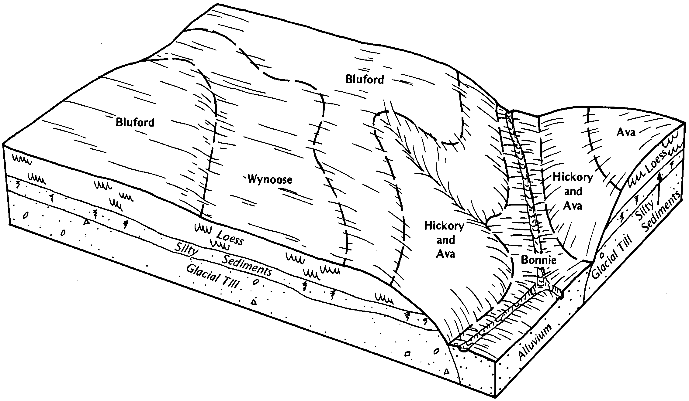
Wynoose silt loam, 0 to 2 percent slopes | 12A | 3942 | 1528914 | 2t959 | il189 | 2006 | 1:12000 |
Wynoose silt loam, 0 to 2 percent slopes | 12A | 33775 | 1906363 | 2t959 | il191 | 2008 | 1:12000 |
Wynoose silt loam, bench, 0 to 2 percent slopes | 639A | 9866 | 3210776 | 2t95n | il191 | 2008 | 1:12000 |
Wynoose silt loam, bench, 0 to 2 percent slopes | 639A | 1528 | 3210777 | 2t95n | il193 | 2006 | 1:12000 |
Wynoose silt loam, 0 to 2 percent slopes | 12A | 744 | 1543850 | 2t959 | il193 | 2006 | 1:12000 |
Wynoose silt loam, bench, 0 to 2 percent slopes | 639A | 4343 | 1478210 | 2t95n | il199 | 2007 | 1:12000 |
Wynoose silt loam, 0 to 2 percent slopes | 12A | 2526 | 1478045 | 2t959 | il199 | 2007 | 1:12000 |