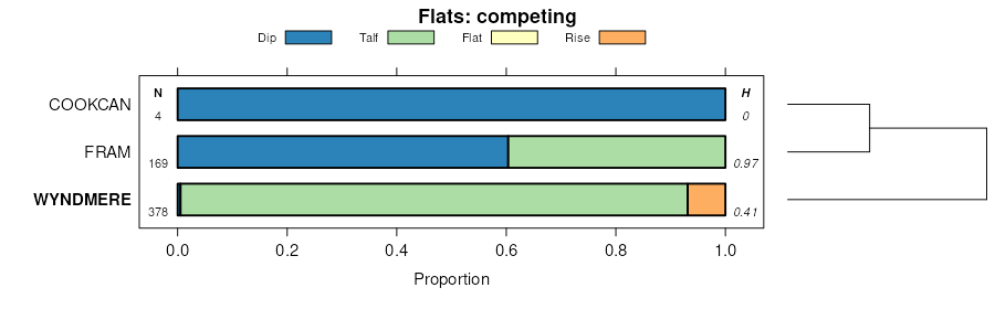
| Wyndmere fine sandy loam | 508 | 924 | 397537 | fbns | mn005 | 1994 | 1:20000 |
Wyndmere fine sandy loam, 0 to 2 percent slopes | I312A | 20266 | 2798084 | 1nywd | mn027 | 1980 | 1:20000 |
Wyndmere, moderately saline-Wyndmere fine sandy loams, 0 to 2 percent slopes | I729A | 999 | 2798148 | 2sx34 | mn027 | 1980 | 1:20000 |
Wyndmere fine sandy loam, 0 to 2 percent slopes | I312A | 27 | 2798186 | 1nywd | mn051 | 1974 | 1:20000 |
Wyndmere fine sandy loam, 0 to 2 percent slopes | I312A | 349 | 2799143 | 1nywd | mn111 | 1996 | 1:20000 |
Wyndmere fine sandy loam | 508 | 4 | 435854 | gmjt | mn111 | 1996 | 1:20000 |
Wyndmere fine sandy loam, 0 to 2 percent slopes | I312A | 9405 | 2800003 | 1nywd | mn167 | 1985 | 1:20000 |
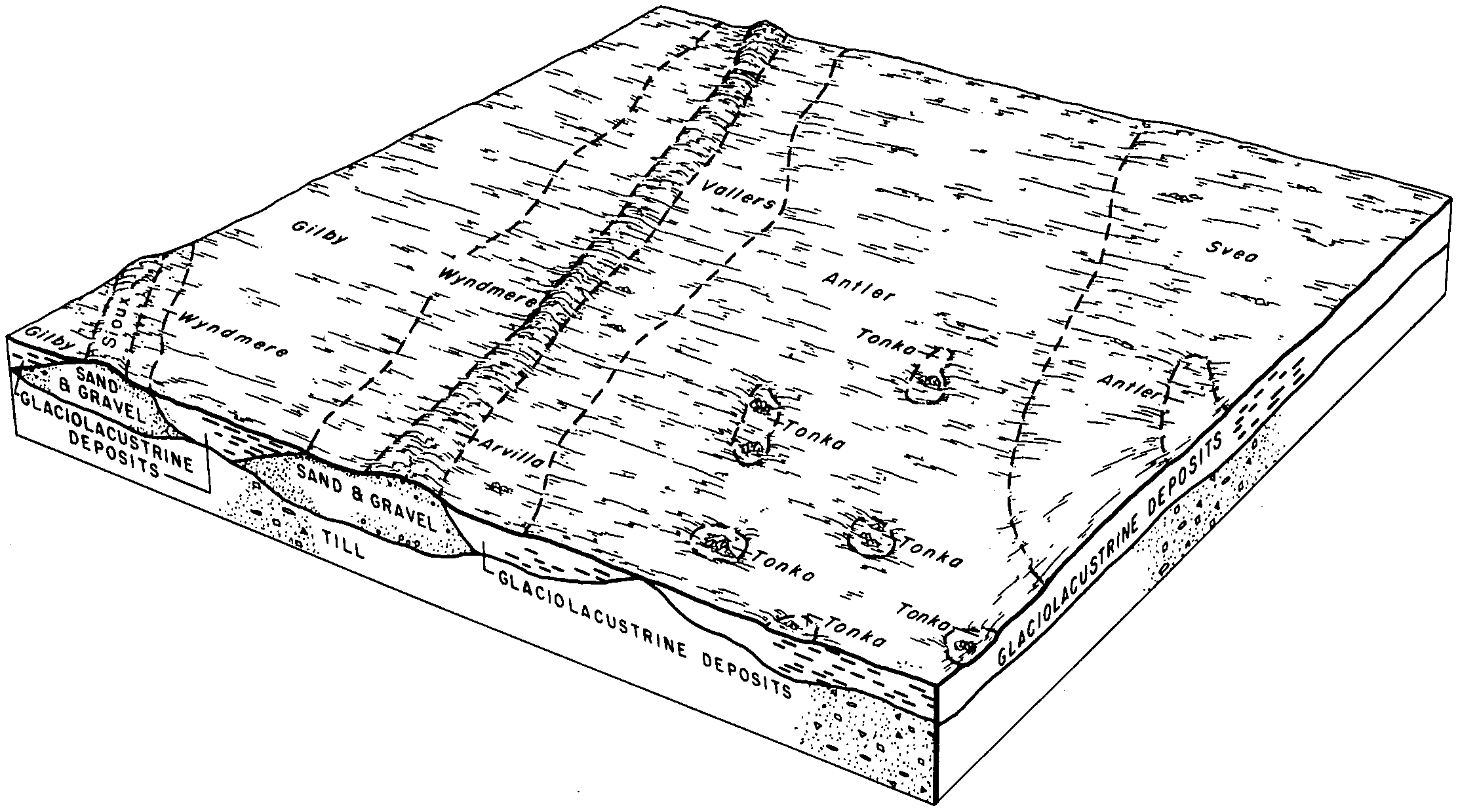
Vallers-Hamerly-Wyndmere complex, seep, 2 to 6 percent slopes | G700B | 747 | 2573783 | 2q5wh | nd005 | | 1:12000 |
Wyndmere fine sandy loam, 0 to 2 percent slopes | G329A | 255 | 2573743 | 2q4zx | nd005 | | 1:12000 |
Wyndmere fine sandy loam, 0 to 2 percent slopes | F329A | 21360 | 2585880 | 2q53z | nd009 | 1981 | 1:20000 |
Kratka-Wyndmere fine sandy loams, 0 to 2 percent slopes | F326A | 918 | 2585855 | 2q53y | nd013 | 1991 | 1:24000 |
Kratka-Wyndmere fine sandy loams, 0 to 2 percent slopes | 2192 | 575 | 341133 | cfz9 | nd013 | 1991 | 1:24000 |
Wyndmere loam, 0 to 2 percent slopes | I211A | 17452 | 2521581 | 1nys6 | nd017 | 1983 | 1:20000 |
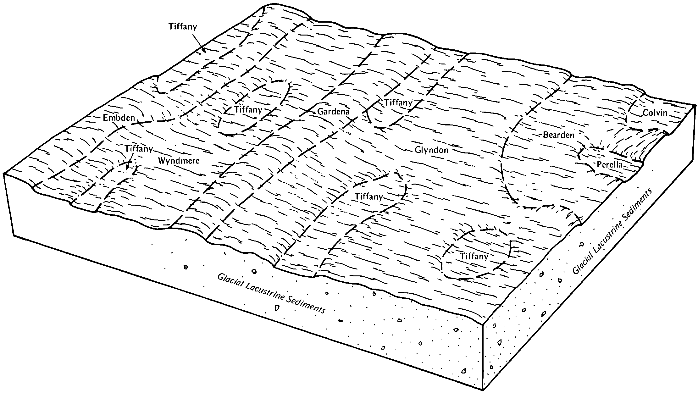
Wyndmere-Tiffany loams, 0 to 2 percent slopes | I489A | 6062 | 2521617 | 1tbmc | nd017 | 1983 | 1:20000 |
Embden-Wyndmere fine sandy loams, 0 to 2 percent slopes | I496A | 4888 | 2521614 | 1tbn3 | nd017 | 1983 | 1:20000 |
Embden-Wyndmere loams, 0 to 2 percent slopes | I426A | 2955 | 3108436 | 2xpp9 | nd017 | 1983 | 1:20000 |
Wyndmere-Tiffany loams, 0 to 2 percent slopes | G336A | 598 | 2575070 | 2q61p | nd017 | 1983 | 1:20000 |
Mantador-Delamere-Wyndmere loams, slightly saline, stratified substratum, 0 to 2 percent slopes | I217A | 549 | 2640861 | 1nysf | nd017 | 1983 | 1:20000 |
Wyndmere, moderately saline-Wyndmere fine sandy loams, 0 to 2 percent slopes | I729A | 482 | 2945932 | 2sx34 | nd017 | 1983 | 1:20000 |
Mantador-Delamere-Wyndmere fine sandy loams, 0 to 2 percent slopes | I314A | 73 | 2640845 | 1nywg | nd017 | 1983 | 1:20000 |
Wyndmere fine sandy loam, 0 to 2 percent slopes | I312A | 58 | 2640859 | 1nywd | nd017 | 1983 | 1:20000 |
Wyndmere-Tiffany fine sandy loams, 0 to 2 percent slopes | G332A | 4551 | 2575313 | 2q500 | nd021 | 1989 | 1:20000 |
Wyndmere fine sandy loam, loamy substratum, 0 to 3 percent slopes | C447A | 100 | 2564236 | 2q73g | nd021 | 1989 | 1:20000 |
Wyndmere fine sandy loam, 0 to 2 percent slopes | G329A | 30 | 2575312 | 2q4zx | nd021 | 1989 | 1:20000 |
Wyndmere fine sandy loam, 0 to 2 percent slopes | G329A | 2354 | 2576286 | 2q4zx | nd027 | | 1:12000 |
Wyndmere fine sandy loam, loamy substratum, 0 to 2 percent slopes | G330A | 2277 | 2576287 | 2q4zy | nd027 | | 1:12000 |
Vallers-Hamerly-Wyndmere complex, seep, 2 to 6 percent slopes | G700B | 1419 | 2576347 | 2q5wh | nd027 | | 1:12000 |
Wyndmere-Arveson complex, loamy substratums, 0 to 2 percent slopes | G343A | 3009 | 2576438 | 2q508 | nd031 | 1990 | 1:20000 |
Wyndmere fine sandy loam, loamy substratum, 0 to 2 percent slopes | G330A | 47 | 2576434 | 2q4zy | nd031 | 1990 | 1:20000 |
Wyndmere fine sandy loam, 0 to 2 percent slopes | G329A | 24 | 2576433 | 2q4zx | nd031 | 1990 | 1:20000 |
Wyndmere-Tiffany fine sandy loams, 0 to 2 percent slopes | I159A | 23283 | 2642595 | 2mbp8 | nd035 | 1980 | 1:20000 |
Wyndmere fine sandy loam, 0 to 2 percent slopes | I312A | 12214 | 2642546 | 1nywd | nd035 | 1980 | 1:20000 |
Embden-Wyndmere fine sandy loams, 0 to 2 percent slopes | I496A | 4661 | 2642523 | 1tbn3 | nd035 | 1980 | 1:20000 |
Wyndmere loam, 0 to 2 percent slopes | I211A | 99 | 2642535 | 1nys6 | nd035 | 1980 | 1:20000 |
Wyndmere fine sandy loam, loamy substratum, 0 to 2 percent slopes | G330A | 2506 | 2576621 | 2q4zy | nd039 | 1991 | 1:24000 |
Wyndmere-Tiffany fine sandy loams, 0 to 2 percent slopes | G332A | 3 | 2577065 | 2q500 | nd045 | 1966 | 1:20000 |
Wyndmere fine sandy loam, 0 to 2 percent slopes | F329A | 21723 | 2585578 | 2q53z | nd049 | 1987 | 1:20000 |
Wyndmere fine sandy loam, saline, 0 to 2 percent slopes | F353A | 3732 | 2585694 | 2q546 | nd049 | 1987 | 1:20000 |
Wyndmere fine sandy loam, 0 to 2 percent slopes | G329A | 1823 | 2571356 | 2q4zx | nd049 | 1987 | 1:20000 |
Wyndmere fine sandy loam, saline, 0 to 2 percent slopes | G353A | 815 | 2571359 | 2q50f | nd049 | 1987 | 1:20000 |
Wyndmere fine sandy loam, 0 to 2 percent slopes | G329A | 267 | 2577314 | 2q4zx | nd063 | | 1:12000 |
Wyndmere fine sandy loam, loamy substratum, 0 to 2 percent slopes | G330A | 5 | 2577315 | 2q4zy | nd063 | | 1:12000 |
Wyndmere fine sandy loam, 0 to 2 percent slopes | F329A | 3343 | 2587176 | 2q53z | nd069 | 1975 | 1:20000 |
Wyndmere fine sandy loam, 0 to 2 percent slopes | G329A | 409 | 2582299 | 2q4zx | nd069 | 1975 | 1:20000 |
Wyndmere loam, 0 to 2 percent slopes | I211A | 7447 | 2641271 | 1nys6 | nd073 | 1992 | 1:20000 |
Wyndmere-Tiffany loams, 0 to 2 percent slopes | I489A | 2488 | 2641334 | 1tbmc | nd073 | 1992 | 1:20000 |
Wyndmere loam, 0 to 2 percent slopes | G345A | 1133 | 2581166 | 2q509 | nd073 | 1992 | 1:20000 |
Wyndmere loam, slightly saline, stratified substratum, 0 to 2 percent slopes | I207A | 41 | 2641269 | 1nys2 | nd073 | 1992 | 1:20000 |
Wyndmere fine sandy loam, 0 to 2 percent slopes | F329A | 269 | 2585328 | 2q53z | nd075 | 1972 | 1:20000 |
Kratka-Wyndmere fine sandy loams, 0 to 2 percent slopes | F326A | 20 | 2585448 | 2q53y | nd075 | 1972 | 1:20000 |
Mantador-Delamere-Wyndmere fine sandy loams, slightly saline, stratified substratum, 0 to 2 percent slopes | I215A | 37603 | 2641160 | 1nysc | nd077 | 2005 | 1:12000 |
Wyndmere loam, slightly saline, stratified substratum, 0 to 2 percent slopes | I207A | 36334 | 2641080 | 1nys2 | nd077 | 2005 | 1:12000 |
Wyndmere fine sandy loam, slightly saline, stratified substratum, 0 to 2 percent slopes | I216A | 9535 | 2640987 | 1nysd | nd077 | 2005 | 1:12000 |
Mantador-Delamere-Wyndmere loams, slightly saline, stratified substratum, 0 to 2 percent slopes | I217A | 5036 | 2641062 | 1nysf | nd077 | 2005 | 1:12000 |
Mantador-Delamere-Wyndmere fine sandy loams, 0 to 2 percent slopes | I314A | 4355 | 2641033 | 1nywg | nd077 | 2005 | 1:12000 |
Wyndmere fine sandy loam, 0 to 2 percent slopes | I312A | 2862 | 2641059 | 1nywd | nd077 | 2005 | 1:12000 |
Wyndmere loam, 0 to 2 percent slopes | I211A | 1657 | 2640955 | 1nys6 | nd077 | 2005 | 1:12000 |
Wyndmere loam, moderately saline, stratified substratum, 0 to 2 percent slopes | I206A | 960 | 2641004 | 1nys1 | nd077 | 2005 | 1:12000 |
Mantador-Delamere-Wyndmere loams, 0 to 2 percent slopes | I315A | 178 | 2641085 | 1nywh | nd077 | 2005 | 1:12000 |
Wyndmere fine sandy loam, 0 to 2 percent slopes | F329A | 4135 | 2587998 | 2q53z | nd079 | 1990 | 1:24000 |
Embden-Wyndmere fine sandy loams, 0 to 2 percent slopes | I496A | 1909 | 2641251 | 1tbn3 | nd081 | 1959 | 1:12000 |
Wyndmere fine sandy loam, 0 to 2 percent slopes | G329A | 599 | 2579490 | 2q4zx | nd081 | 1959 | 1:12000 |
Embden-Wyndmere fine sandy loams, 0 to 2 percent slopes | G403A | 255 | 2579549 | 2q5c9 | nd081 | 1959 | 1:12000 |
Wyndmere loam, 0 to 2 percent slopes | I211A | 104 | 2641196 | 1nys6 | nd081 | 1959 | 1:12000 |
Wyndmere loam, 0 to 2 percent slopes | G345A | 55 | 2579467 | 2q509 | nd081 | 1959 | 1:12000 |
Wyndmere-Tiffany complex, stratified substratum, 0 to 2 percent slopes | I857A | 5720 | 2641431 | 2qkv0 | nd091 | 1991 | 1:20000 |
Wyndmere loam, 0 to 2 percent slopes | I211A | 69 | 2641368 | 1nys6 | nd091 | 1991 | 1:20000 |
Wyndmere fine sandy loam, 0 to 2 percent slopes | G329A | 29 | 2579756 | 2q4zx | nd091 | 1991 | 1:20000 |
Wyndmere fine sandy loam, 0 to 2 percent slopes | I312A | 2 | 2641373 | 1nywd | nd091 | 1991 | 1:20000 |
Wyndmere fine sandy loam, 0 to 2 percent slopes | G329A | 1679 | 2581367 | 2q4zx | nd093 | 1990 | 1:24000 |
Wyndmere fine sandy loam, loamy substratum, 0 to 3 percent slopes | C447A | 422 | 2566875 | 2q73g | nd093 | 1990 | 1:24000 |
Wyndmere fine sandy loam, loamy substratum, 0 to 2 percent slopes | G330A | 21 | 2581368 | 2q4zy | nd093 | 1990 | 1:24000 |
Wyndmere fine sandy loam, 0 to 2 percent slopes | F329A | 6280 | 2586194 | 2q53z | nd095 | 1992 | 1:24000 |
Wyndmere-Delamere loams, silty substratums, 0 to 2 percent slopes | F342A | 3194 | 2587039 | 2q543 | nd095 | 1992 | 1:24000 |
Wyndmere fine sandy loam, 0 to 2 percent slopes | I312A | 8751 | 2641601 | 1nywd | nd097 | 1974 | 1:20000 |
Wyndmere loam, 0 to 2 percent slopes | I211A | 6239 | 2641577 | 1nys6 | nd097 | 1974 | 1:20000 |
Wyndmere-Tiffany fine sandy loams, 0 to 2 percent slopes | I159A | 2240 | 2642488 | 2mbp8 | nd097 | 1974 | 1:20000 |
Wyndmere loam, moderately saline, 0 to 2 percent slopes | I169A | 412 | 2642483 | 2l6xf | nd097 | 1974 | 1:20000 |
Wyndmere-Tiffany complex, stratified substratum, 0 to 2 percent slopes | I857A | 396 | 2642507 | 2qkv0 | nd097 | 1974 | 1:20000 |
Mantador-Delamere-Wyndmere fine sandy loams, 0 to 2 percent slopes | I314A | 76 | 2641602 | 1nywg | nd097 | 1974 | 1:20000 |
Wyndmere-Tiffany loams, 0 to 2 percent slopes | I489A | 41 | 2642436 | 1tbmc | nd097 | 1974 | 1:20000 |
Embden-Wyndmere fine sandy loams, 0 to 2 percent slopes | I496A | 6 | 2642439 | 1tbn3 | nd097 | 1974 | 1:20000 |
Wyndmere fine sandy loam, 0 to 2 percent slopes | I312A | 1 | 2642840 | 1nywd | nd099 | 1967 | 1:20000 |
Vallers-Hamerly-Wyndmere complex, seep, 2 to 6 percent slopes | G700B | 11 | 2579692 | 2q5wh | nd103 | 1966 | 1:12000 |
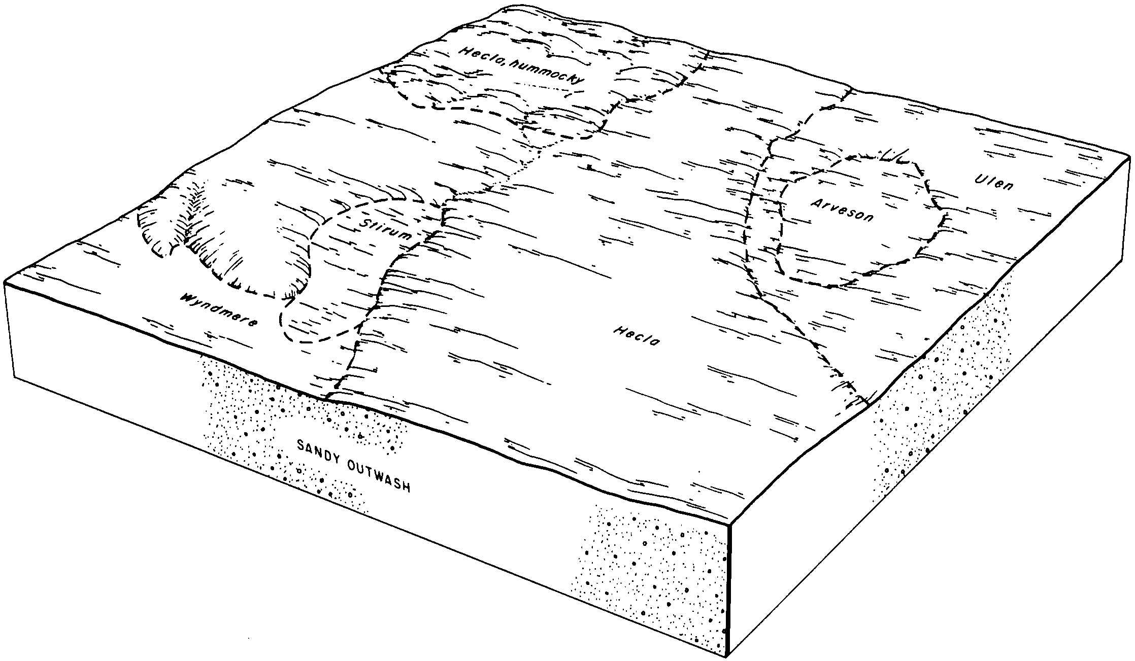
Wyndmere, sandy substratum-Stirum fine sandy loams, 0 to 2 percent slopes | G344A | 2474 | 2797755 | 2sd2m | sd013 | 1987 | 1:20000 |
Wyndmere fine sandy loam, 0 to 2 percent slopes | G329A | 2028 | 2797663 | 2q4zx | sd013 | 1987 | 1:20000 |
Wyndmere loam, 0 to 2 percent slopes | G345A | 308 | 2797667 | 2q509 | sd013 | 1987 | 1:20000 |
Wyndmere-Tiffany fine sandy loams, 0 to 2 percent slopes | G332A | 1 | 2797664 | 2q500 | sd013 | 1987 | 1:20000 |
Wyndmere fine sandy loam, 0 to 2 percent slopes | C446A | 1302 | 2797919 | 2rrqg | sd021 | 1978 | 1:20000 |
Wyndmere-Parnell complex | Wp | 1447 | 417798 | g0rc | sd025 | 1992 | 1:20000 |
Wyndmere fine sandy loam | Wm | 766 | 417797 | g0rb | sd025 | 1992 | 1:20000 |