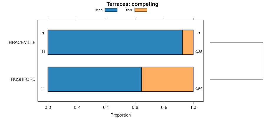
| Wurtsboro silt loam, 0 to 8 percent slopes, extremely stony | WuoBc | 1112 | 298625 | b0r2 | nj031 | 1972 | 1:24000 |
Wurtsboro silt loam, 8 to 15 percent slopes, extremely stony | WuoCc | 372 | 298626 | b0r3 | nj031 | 1972 | 1:24000 |
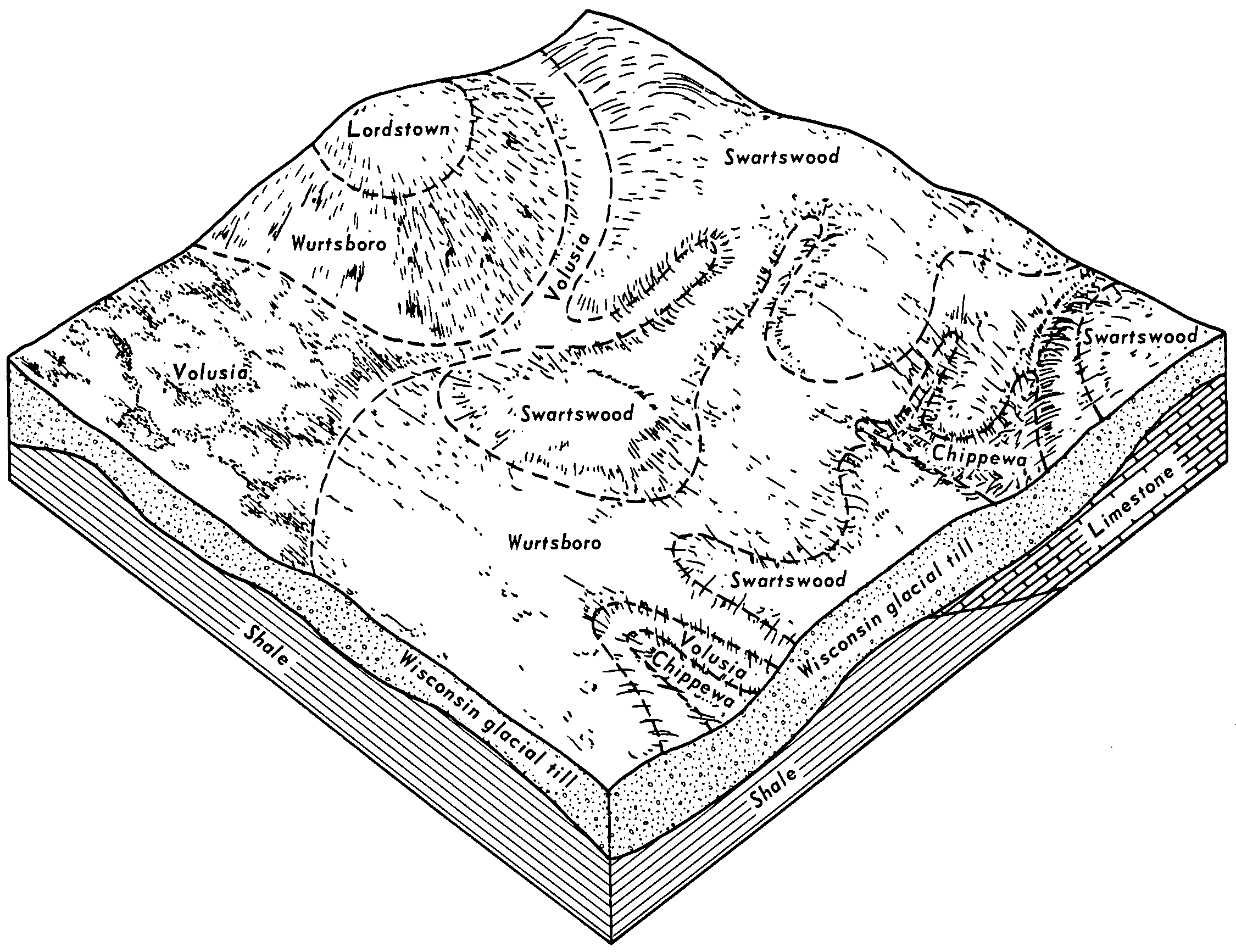
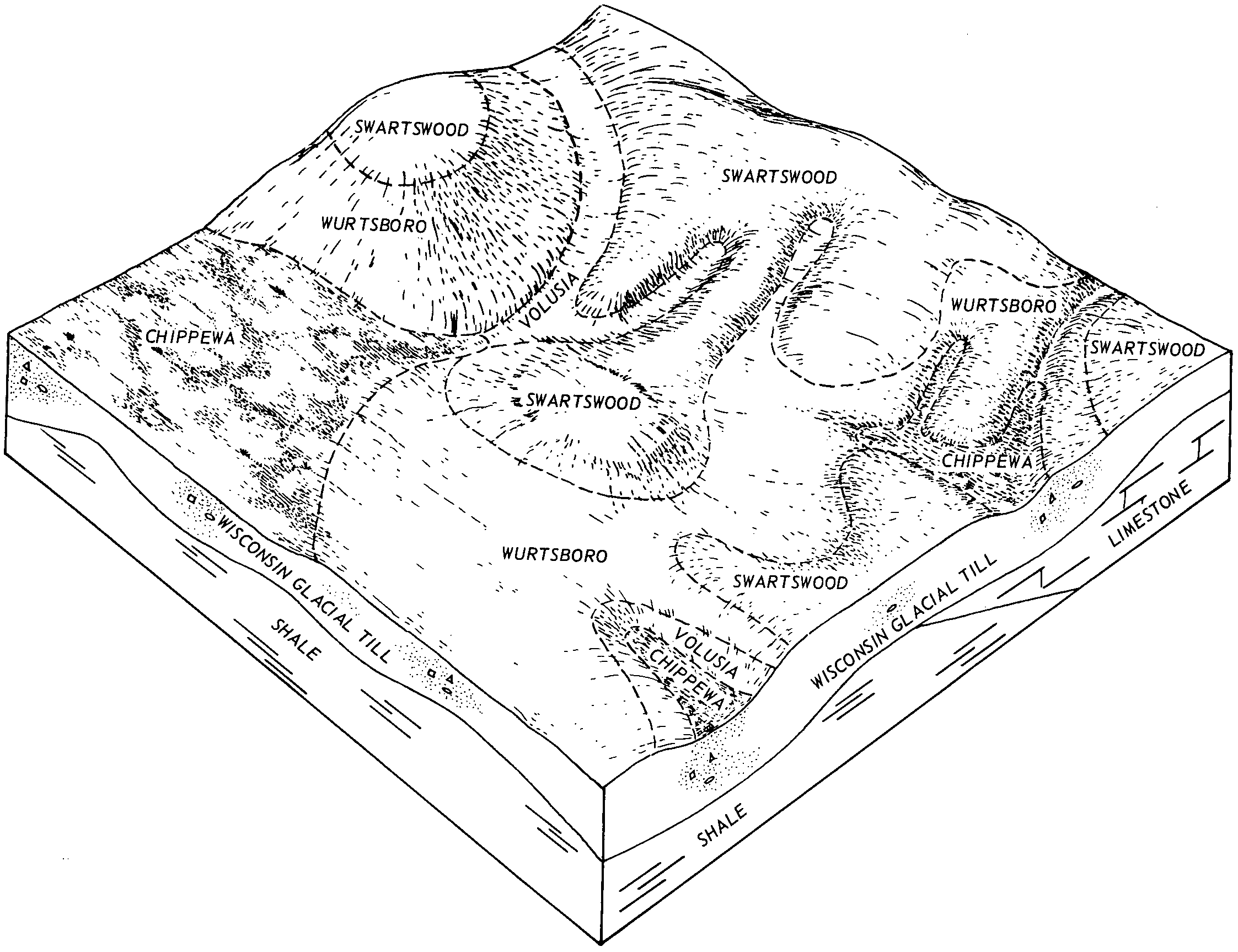
Wurtsboro-Swartswood complex, 8 to 15 percent slopes, extremely stony | WusCc | 8072 | 298051 | b04k | nj037 | 2002 | 1:24000 |
Wurtsboro-Swartswood complex, 0 to 8 percent slopes, extremely stony | WusBc | 7843 | 298050 | b04j | nj037 | 2002 | 1:24000 |
Wurtsboro-Swartswood complex, 15 to 35 percent slopes, extremely stony | WusDc | 3572 | 614075 | nlzw | nj037 | 2002 | 1:24000 |
Wurtsboro loam, 0 to 8 percent slopes, extremely stony | WumBc | 686 | 298049 | b04h | nj037 | 2002 | 1:24000 |
Urban land-Wurtsboro-Swartswood complex, 0 to 8 percent slopes | USWUSB | 66 | 723869 | s97m | nj037 | 2002 | 1:24000 |
Wurtsboro-Swartswood complex, 8 to 15 percent slopes, extremely stony | WusCc | 5428 | 1147502 | 17j26 | nj041 | 2007 | 1:12000 |
Wurtsboro-Swartswood complex, 15 to 35 percent slopes, extremely stony | WusDc | 3379 | 1147533 | 17j36 | nj041 | 2007 | 1:12000 |
Wurtsboro-Swartswood complex, 0 to 8 percent slopes, extremely stony | WusBc | 2533 | 1147501 | 17j25 | nj041 | 2007 | 1:12000 |
Wurtsboro loam, 0 to 8 percent slopes, extremely stony | WumBc | 19 | 1147500 | 17j24 | nj041 | 2007 | 1:12000 |
Wurtsboro gravelly loam, 3 to 8 percent slopes | WuB | 928 | 293991 | 9vxl | ny071 | 1976 | 1:15840 |
Wurtsboro gravelly loam, 8 to 15 percent slopes | WuC | 832 | 293992 | 9vxm | ny071 | 1976 | 1:15840 |
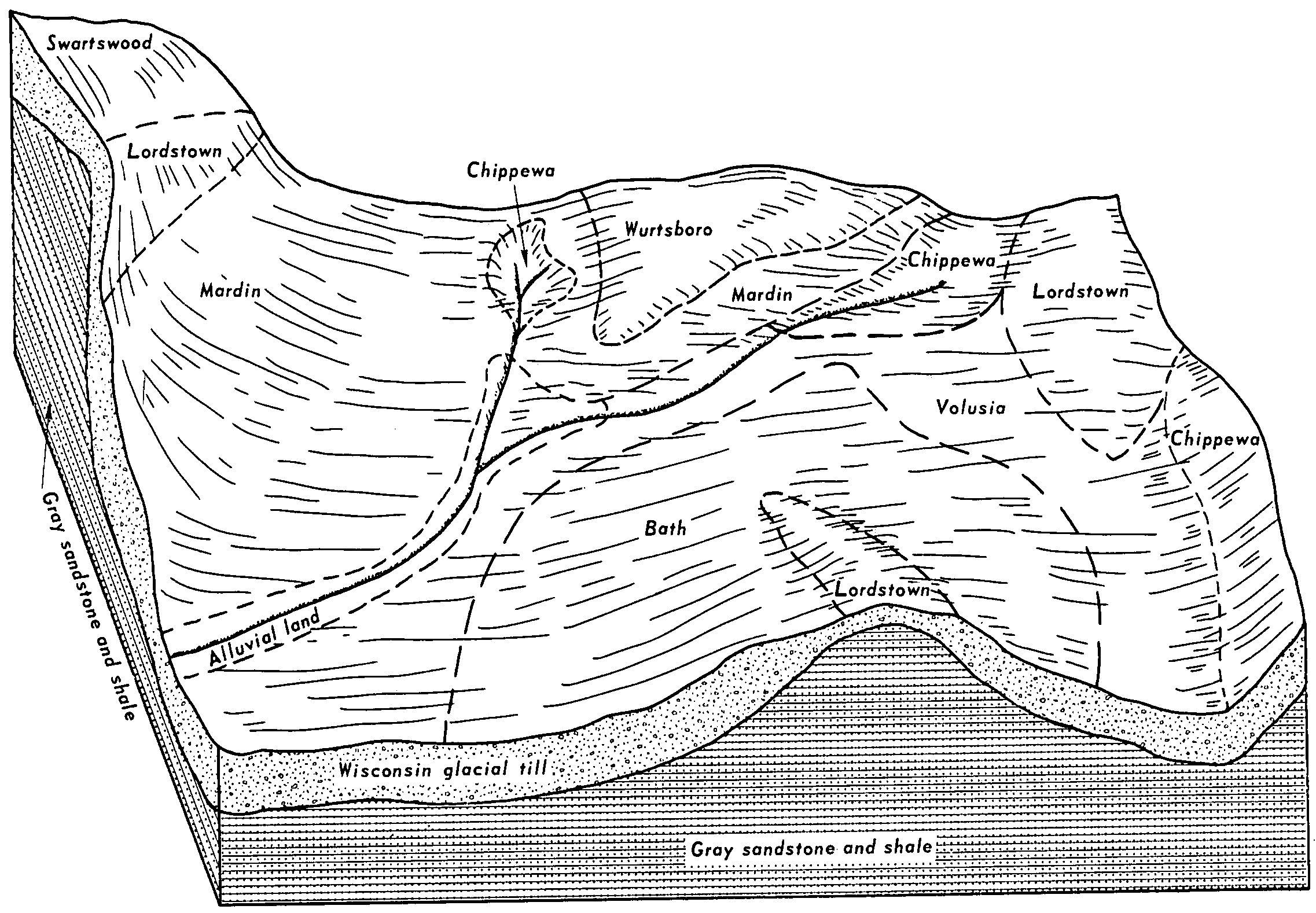
Wellsboro and Wurtsboro soils, strongly sloping, extremely stony | WlC | 89369 | 295157 | 9x46 | ny105 | 1984 | 1:15840 |
Wurtsboro loam, 3 to 8 pecent slopes, stony | WuB | 17302 | 295163 | 9x4d | ny105 | 1984 | 1:15840 |
Wurtsboro loam, 8 to 15 percent slopes, stony | WuC | 6297 | 295164 | 9x4f | ny105 | 1984 | 1:15840 |
Wurtsboro loam, 0 to 3 percent slopes, stony | WuA | 2476 | 295162 | 9x4c | ny105 | 1984 | 1:15840 |
Wellsboro and Wurtsboro soils, gently sloping, very bouldery | WLB | 31847 | 295570 | 2vckr | ny111 | 1974 | 1:15840 |
Wellsboro and Wurtsboro soils, gently sloping, extremely bouldery | WOB | 4292 | 295571 | 2vcks | ny111 | 1974 | 1:15840 |
Wurtsboro stony loam, 3 to 8 percent slopes | WuB | 204 | 295574 | 9xkn | ny111 | 1974 | 1:15840 |
Wurtsboro very stony loam, 0 to 8 percent slopes | WvB | 2501 | 539433 | l3b2 | pa025 | 1960 | 1:20000 |
Wurtsboro very stony loam, 8 to 25 percent slopes | WvD | 241 | 539434 | l3b3 | pa025 | 1960 | 1:20000 |
Wurtsboro channery loam, 0 to 3 percent slopes | WuA | 39 | 539431 | l3b0 | pa025 | 1960 | 1:20000 |
Wurtsboro channery loam, 3 to 8 percent slopes, moderately eroded | WuB2 | 33 | 539432 | l3b1 | pa025 | 1960 | 1:20000 |
Wurtsboro channery loam, 3 to 8 percent slopes | WkB | 1683 | 299361 | b1ht | pa069 | 1976 | 1:20000 |
Wurtsboro channery loam, 8 to 15 percent slopes | WkC | 1654 | 299362 | b1hv | pa069 | 1976 | 1:20000 |
Wurtsboro extremely stony loam, 3 to 8 percent slopes | WxB | 1305 | 299363 | b1hw | pa069 | 1976 | 1:20000 |
Wurtsboro extremely stony loam, 8 to 25 percent slopes | WxD | 1020 | 299364 | b1hx | pa069 | 1976 | 1:20000 |
Wurtsboro extremely stony loam, 3 to 8 percent slopes | WtB | 3999 | 296503 | 9yjm | pa079 | 1974 | 1:20000 |
Wurtsboro channery loam, 3 to 8 percent slopes | WrB | 3741 | 296500 | 9yjj | pa079 | 1974 | 1:20000 |
Wurtsboro extremely stony loam, 8 to 25 percent slopes | WtD | 2850 | 296504 | 9yjn | pa079 | 1974 | 1:20000 |
Wurtsboro channery loam, 8 to 15 percent slopes | WrC | 2340 | 296501 | 9yjk | pa079 | 1974 | 1:20000 |
Wurtsboro channery loam, 15 to 25 percent slopes | WrD | 381 | 296502 | 9yjl | pa079 | 1974 | 1:20000 |
Wurtsboro very stony sandy loam, 0 to 8 percent slopes | WxB | 4077 | 539145 | l30s | pa081 | 1981 | 1:20000 |
Wurtsboro very stony sandy loam, 8 to 25 percent slopes | WxD | 1838 | 539146 | l30t | pa081 | 1981 | 1:20000 |
Wurtsboro extremely stony loam, 0 to 8 percent slopes | WxB | 17354 | 296383 | 9ydr | pa089 | 1975 | 1:20000 |
Wurtsboro extremely stony loam, 8 to 25 percent slopes | WxC | 2472 | 296384 | 9yds | pa089 | 1975 | 1:20000 |
Wurtsboro channery loam, 2 to 12 percent slopes | WsB | 869 | 296382 | 9ydq | pa089 | 1975 | 1:20000 |
Wurtsboro stony fine sandy loam, 0 to 8 percent slopes, extremely stony | 30B | 493 | 319903 | bqwg | pa089 | 1975 | 1:20000 |
Wurtsboro stony fine sandy loam, 8 to 15 percent slopes, extremely stony | 30C | 8 | 319904 | bqwh | pa089 | 1975 | 1:20000 |
Swartswood and Wurtsboro soils, 0 to 8 percent slopes, extremely stony | SwB | 2632 | 543330 | l7cs | pa095 | 2007 | 1:12000 |
Wurtsboro gravelly silt loam, 3 to 8 percent slopes | WuB | 2631 | 543374 | l7f6 | pa095 | 2007 | 1:12000 |
Swartswood and Wurtsboro soils, 8 to 25 percent slopes, extremely stony | SwD | 1359 | 543331 | l7ct | pa095 | 2007 | 1:12000 |
Wurtsboro gravelly silt loam, 8 to 15 percent slopes | WuC | 741 | 543375 | l7f7 | pa095 | 2007 | 1:12000 |
Wurtsboro stony fine sandy loam, 0 to 8 percent slopes, extremely stony | 30B | 40895 | 297216 | 9z8m | pa103 | 1995 | 1:24000 |
Wurtsboro stony fine sandy loam, 8 to 15 percent slopes, extremely stony | 30C | 20301 | 297217 | 9z8n | pa103 | 1995 | 1:24000 |
Wurtsboro stony fine sandy loam, 15 to 25 percent slopes, extremely stony | 30D | 3177 | 297218 | 9z8p | pa103 | 1995 | 1:24000 |
Wurtsboro channery fine sandy loam, 0 to 8 percent slopes, stony | 25B | 2226 | 297207 | 9z8b | pa103 | 1995 | 1:24000 |
Wurtsboro channery fine sandy loam, 8 to 15 percent slopes, stony | 25C | 477 | 297208 | 9z8c | pa103 | 1995 | 1:24000 |
Wurtsboro channery loam, 8 to 15 percent slopes | WkC | 1 | 319834 | bqt7 | pa115 | 1968 | 1:20000 |
Wurtsboro stony fine sandy loam, 0 to 8 percent slopes, extremely stony | 30B | 144 | 319866 | bqv8 | pa127 | 1977 | 1:20000 |
Wurtsboro stony fine sandy loam, 8 to 15 percent slopes, extremely stony | 30C | 12 | 319867 | bqv9 | pa127 | 1977 | 1:20000 |
Wurtsboro channery loam, 3 to 8 percent slopes | WkB | 6 | 319880 | bqvq | pa127 | 1977 | 1:20000 |
Wurtsboro channery loam, 8 to 15 percent slopes | WkC | 1 | 319881 | bqvr | pa127 | 1977 | 1:20000 |
Wurtsboro channery loam, 8 to 15 percent slopes | WkC | 215 | 301992 | b47p | pa131 | 1976 | 1:20000 |
Wurtsboro extremely stony loam, 3 to 8 percent slopes | WxB | 178 | 301993 | b47q | pa131 | 1976 | 1:20000 |
Wurtsboro channery loam, 3 to 8 percent slopes | WkB | 98 | 301991 | b47n | pa131 | 1976 | 1:20000 |
Wurtsboro extremely stony loam, 8 to 25 percent slopes | WxD | 72 | 301994 | b47r | pa131 | 1976 | 1:20000 |
Wurtsboro extremely stony loam, 3 to 8 percent slopes | WtB | 36 | 1452555 | 1krhm | pa610 | 1978 | 1:20000 |
Wurtsboro channery loam, 3 to 8 percent slopes | WrB | 24 | 1452552 | 1krhj | pa610 | 1978 | 1:20000 |
Wurtsboro extremely stony loam, 8 to 25 percent slopes | WtD | 16 | 1452556 | 1krhn | pa610 | 1978 | 1:20000 |
Wurtsboro channery loam, 8 to 15 percent slopes | WrC | 2 | 1452553 | 1krhk | pa610 | 1978 | 1:20000 |
Wurtsboro channery loam, 15 to 25 percent slopes | WrD | 2 | 1452554 | 1krhl | pa610 | 1978 | 1:20000 |


