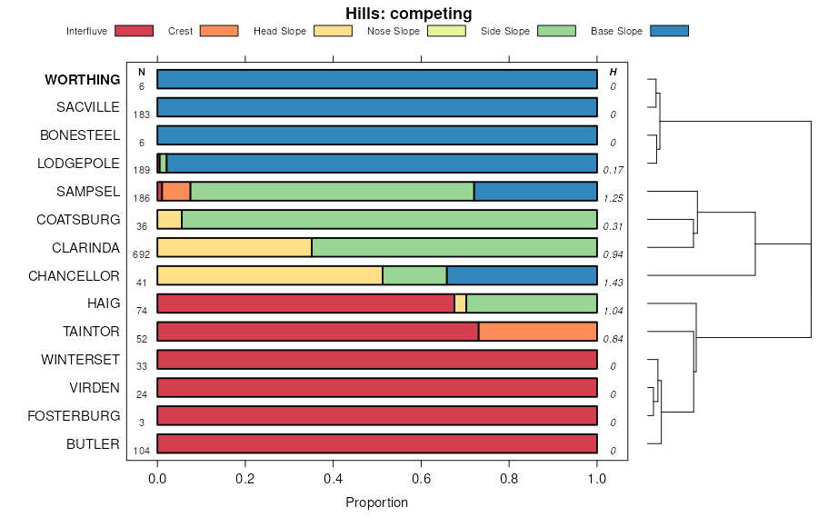
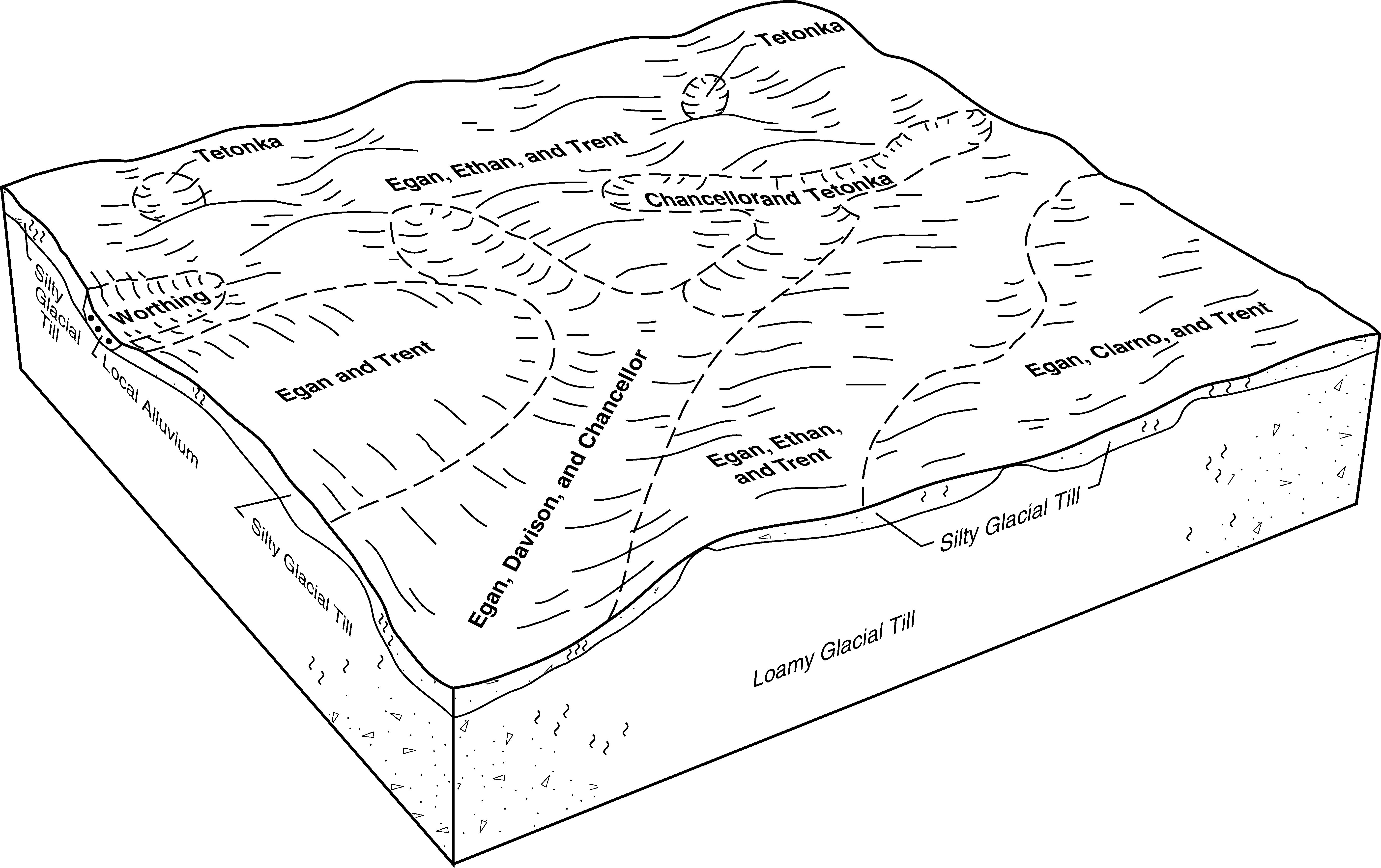
| Worthing silty clay loam, ponded, 0 to 1 percent slopes | Wp | 4604 | 354871 | 2tlcj | sd003 | 1979 | 1:20000 |
Worthing silty clay loam, 0 to 1 percent slopes | Wo | 3179 | 354870 | 2tlch | sd003 | 1979 | 1:20000 |
Worthing silty clay loam, ponded, 0 to 1 percent slopes | Ao | 6751 | 354545 | 2tlcj | sd005 | 1976 | 1:20000 |
Worthing silty clay loam, ponded, 0 to 1 percent slopes | Wo | 1630 | 418293 | 2tlcj | sd009 | 1981 | 1:20000 |
Worthing silty clay loam, 0 to 1 percent slopes | Wg | 1531 | 418292 | 2tlch | sd009 | 1981 | 1:20000 |
Worthing silty clay loam, 0 to 1 percent slopes | Wo | 4 | 418824 | 2tlch | sd011 | 1995 | 1:24000 |
Worthing silty clay loam, ponded, 0 to 1 percent slopes | Wp | 4369 | 355078 | 2tlcj | sd023 | 1980 | 1:20000 |
Worthing silty clay loam, 0 to 1 percent slopes | Wo | 4340 | 355077 | 2tlch | sd023 | 1980 | 1:20000 |
Worthing silty clay loam, 0 to 1 percent slopes | Wg | 343 | 417796 | 2tlch | sd025 | 1992 | 1:20000 |
Worthing silty clay loam, 0 to 1 percent slopes | Wo | 623 | 445626 | 2tlch | sd027 | 1995 | 1:24000 |
Worthing silty clay loam, ponded, 0 to 1 percent slopes | Wp | 148 | 445627 | 2tlcj | sd027 | 1995 | 1:24000 |
Worthing silty clay loam, ponded, 0 to 1 percent slopes | Wp | 138 | 352942 | 2tlcj | sd035 | 1966 | 1:20000 |
Worthing silty clay loam, 0 to 1 percent slopes | Wo | 111 | 352897 | 2tlch | sd035 | 1966 | 1:20000 |
Worthing silty clay loam, 0 to 1 percent slopes | Wo | 3714 | 354916 | 2tlch | sd043 | 1979 | 1:20000 |
Worthing silty clay loam, ponded, 0 to 1 percent slopes | Wp | 2431 | 354917 | 2tlcj | sd043 | 1979 | 1:20000 |
Worthing silty clay loam, ponded, 0 to 1 percent slopes | Mb | 13 | 354272 | 2tlcj | sd045 | 1973 | 1:20000 |
Worthing silty clay loam, 0 to 1 percent slopes | Pa | 1 | 354278 | 2tlch | sd045 | 1973 | 1:20000 |
Worthing silty clay loam, 0 to 1 percent slopes | Pa | 3635 | 355188 | 2tlch | sd049 | 1981 | 1:20000 |
Worthing silty clay loam, ponded, 0 to 1 percent slopes | Pp | 646 | 355189 | 2tlcj | sd049 | 1981 | 1:20000 |
Worthing silty clay loam, ponded, 0 to 1 percent slopes | Wp | 4070 | 352630 | 2tlcj | sd059 | 1959 | 1:20000 |
Worthing silty clay loam, 0 to 1 percent slopes | Wo | 3598 | 352591 | 2tlch | sd059 | 1959 | 1:20000 |
Worthing silty clay loam, 0 to 1 percent slopes | Wo | 4027 | 356462 | 2tlch | sd073 | 1987 | 1:20000 |
Worthing silty clay loam, ponded, 0 to 1 percent slopes | Wp | 2260 | 356463 | 2tlcj | sd073 | 1987 | 1:20000 |
Worthing silty clay loam, 0 to 1 percent slopes | Wo | 3765 | 417524 | 2tlch | sd077 | 1992 | 1:20000 |
Worthing silty clay loam, ponded, 0 to 1 percent slopes | Wp | 1699 | 417525 | 2tlcj | sd077 | 1992 | 1:20000 |
Worthing silty clay loam, 0 to 1 percent slopes | Wo | 17544 | 416523 | 2tlch | sd079 | 1967 | 1:20000 |
Worthing silty clay loam, ponded, 0 to 1 percent slopes | Mar | 11091 | 416506 | 2tlcj | sd079 | 1967 | 1:20000 |
Worthing silty clay loam, 0 to 1 percent slopes | Ws | 8095 | 416665 | 2tlch | sd083 | 1971 | 1:20000 |
Egan-Worthing complex, 0 to 6 percent slopes | EwB | 4626 | 416642 | fzk2 | sd083 | 1971 | 1:20000 |
Worthing silty clay loam, 0 to 1 percent slopes | Wo | 8977 | 418044 | 2tlch | sd087 | 1976 | 1:20000 |
Worthing silty clay loam, 0 to 1 percent slopes | Wo | 6722 | 355411 | 2tlch | sd097 | 1983 | 1:20000 |
Worthing silty clay loam, ponded, 0 to 1 percent slopes | Wp | 3275 | 355412 | 2tlcj | sd097 | 1983 | 1:20000 |
Worthing-Davison complex, 0 to 2 percent slopes | Wr | 8863 | 446091 | gz61 | sd099 | 1995 | 1:24000 |
Worthing silty clay loam, 0 to 1 percent slopes | Wo | 3068 | 446090 | 2tlch | sd099 | 1995 | 1:24000 |
Worthing silty clay loam, 0 to 1 percent slopes | Wo | 3219 | 418359 | 2tlch | sd101 | 1985 | 1:20000 |
Worthing silty clay loam, 0 to 1 percent slopes | Wo | 4952 | 355377 | 2tlch | sd107 | 1983 | 1:20000 |
Worthing silty clay loam, ponded, 0 to 1 percent slopes | Wp | 528 | 355378 | 2tlcj | sd107 | 1983 | 1:20000 |
Worthing silty clay loam, ponded, 0 to 1 percent slopes | Wk | 7871 | 354821 | 2tlcj | sd111 | 1978 | 1:20000 |
Worthing silty clay loam, 0 to 1 percent slopes | We | 2791 | 354820 | 2tlch | sd111 | 1978 | 1:20000 |
Worthing silty clay loam, ponded, 0 to 1 percent slopes | Ww | 1476 | 356733 | 2tlcj | sd115 | 1997 | 1:24000 |
Worthing silty clay loam, 0 to 1 percent slopes | Wt | 1241 | 356732 | 2tlch | sd115 | 1997 | 1:24000 |
Worthing silty clay loam, 0 to 1 percent slopes | Wo | 4706 | 418245 | 2tlch | sd125 | 1980 | 1:20000 |
Wakonda-Worthing-Chancellor complex | Wa | 11618 | 453725 | h749 | sd127 | 1974 | 1:20000 |
Wentworth-Worthing silty clay loams | Wc | 4276 | 453728 | h74d | sd127 | 1974 | 1:20000 |
Worthing-Chancellor silty clay loams | Ws | 2597 | 453731 | h74h | sd127 | 1974 | 1:20000 |
Worthing silty clay loam, 0 to 1 percent slopes | Wo | 991 | 453730 | 2tlch | sd127 | 1974 | 1:20000 |
Worthing silty clay loam, ponded, 0 to 1 percent slopes | Ao | 1020 | 354473 | 2tlcj | sd129 | 1975 | 1:20000 |
Worthing silty clay loam, 0 to 1 percent slopes | Pa | 4 | 354516 | 2tlch | sd129 | 1975 | 1:20000 |
Worthing silty clay loam, 0 to 1 percent slopes | Wd | 1941 | 418113 | 2tlch | sd135 | 1977 | 1:20000 |
Worthing silty clay loam, ponded, 0 to 1 percent slopes | We | 1155 | 418114 | 2tlcj | sd135 | 1977 | 1:20000 |
Worthing silty clay loam, 0 to 1 percent slopes | Ww | 7769 | 418001 | 2tlch | sd602 | 1975 | 1:20000 |
Worthing silty clay loam, ponded, 0 to 1 percent slopes | Ma | 5050 | 417988 | 2tlcj | sd602 | 1975 | 1:20000 |
Worthing silty clay loam, 0 to 1 percent slopes | Wo | 8316 | 355555 | 2tlch | sd603 | 1983 | 1:20000 |
Worthing silty clay loam, ponded, 0 to 1 percent slopes | Wp | 3597 | 355556 | 2tlcj | sd603 | 1983 | 1:20000 |