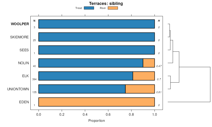
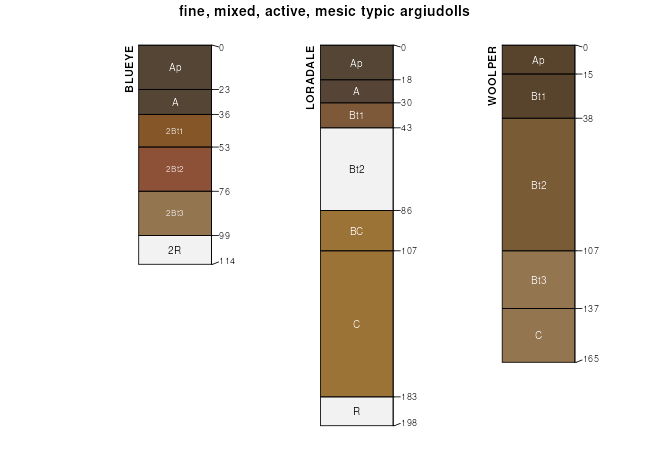
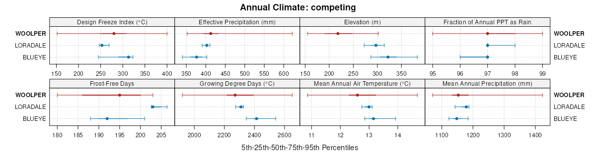
| Woolper silt loam, 1 to 5 percent slopes | 29 | 575 | 564577 | lyh5 | ar135 | 1981 | 1:20000 |
Woolper silty clay loam, 1 to 6 percent slopes | WoB | 804 | 162314 | 5fwy | in047 | 1984 | 1:15840 |
Woolper silty clay loam, 3 to 10 percent slopes | WvC | 352 | 535298 | kz0p | in155 | 1984 | 1:15840 |
Lowell-Woolper complex, 6 to 12 percent slopes | LwC | 736 | 1727488 | 1vzlf | ky011 | 2006 | 1:12000 |
Woolper silty clay loam, 0 to 6 percent slopes | WoB | 703 | 1727487 | 1vzld | ky011 | 2006 | 1:12000 |
Woolper silty clay loam, 6 to 12 percent slopes | WoC | 711 | 550230 | lgkc | ky049 | 1962 | 1:15840 |
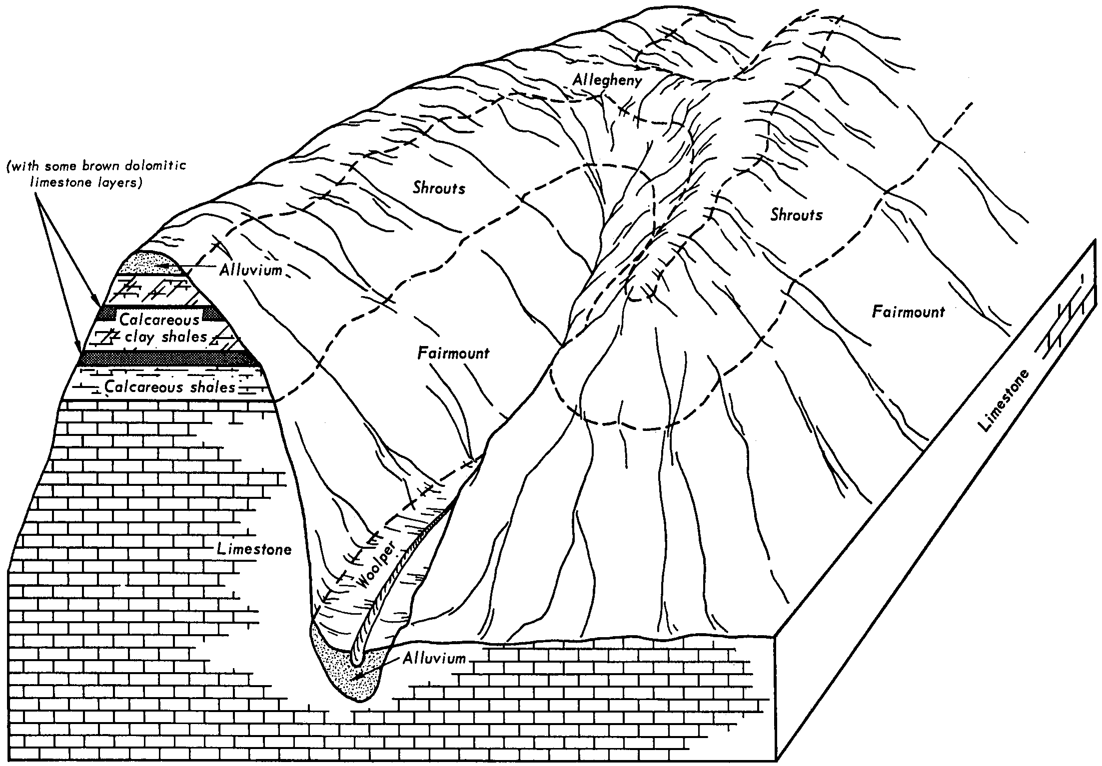
Fairmount-Woolper complex, very rocky, 20 to 60 percent slopes | FaF | 4154 | 552710 | lk4c | ky069 | 1989 | 1:20000 |
Woolper silt loam, 2 to 6 percent slopes, rarely flooded | WoB | 1381 | 552747 | lk5k | ky069 | 1989 | 1:20000 |
Woolper silt loam, 6 to 12 percent slopes, rarely flooded | WoC | 130 | 1533054 | 1ng8c | ky111 | 2005 | 1:12000 |
Woolper silt loam, 2 to 6 percent slopes, rarely flooded | WoB | 104 | 1533053 | 1ng8b | ky111 | 2005 | 1:12000 |
Woolper silt loam, 0 to 2 percent slopes, rarely flooded | WoA | 20 | 1533052 | 1ng89 | ky111 | 2005 | 1:12000 |
Woolper silty clay loam, 2 to 6 percent slopes, rarely flooded | WoB | 1663 | 550334 | lgnq | ky135 | 1998 | 1:20000 |
Woolper silty clay loam, 6 to 12 percent slopes | WoC | 333 | 550335 | lgnr | ky135 | 1998 | 1:20000 |
Woolper silty clay loam, 6 to 12 percent slopes | WoC | 1036 | 1397932 | 1hxnl | ky151 | 1968 | 1:20000 |
Woolper silty clay loam, 2 to 6 percent slopes | WoB | 506 | 1397931 | 1hxnk | ky151 | 1968 | 1:20000 |
Woolper very stony silty clay loam, 12 to 30 percent slopes | WpE | 412 | 1397933 | 1hxnm | ky151 | 1968 | 1:20000 |
Woolper silty clay loam, 2 to 8 percent slopes | WoB | 312 | 550551 | lgwq | ky173 | 1983 | 1:20000 |
Woolper silty clay loam, 2 to 6 percent slopes | WoB | 1050 | 550021 | lgbm | ky179 | 1967 | 1:15840 |
Woolper silty clay loam, 6 to 12 percent slopes | WoC | 735 | 550022 | lgbn | ky179 | 1967 | 1:15840 |
Woolper silty clay loam, 12 to 20 percent slopes, eroded | WoD2 | 285 | 550023 | lgbp | ky179 | 1967 | 1:15840 |
Woolper silty clay loam, 2 to 6 percent slopes | WoB | 280 | 551607 | lhzs | ky185 | 1975 | 1:20000 |
Woolper silty clay loam, 6 to 12 percent slopes | WoC | 230 | 551608 | lhzt | ky185 | 1975 | 1:20000 |
Woolper silty clay loam, 6 to 12 percent slopes | WoC | 670 | 552509 | ljxw | ky207 | 1979 | 1:20000 |
Woolper-Fairmount complex, 30 to 65 percent slopes | WpF | 1070 | 551672 | lj1w | ky211 | 1978 | 1:20000 |
Woolper silty clay loam, 2 to 6 percent slopes | WoB | 240 | 551671 | lj1v | ky211 | 1978 | 1:20000 |
Woolper silty clay loam, 12 to 20 percent slopes | WoD | 355 | 552070 | ljgq | ky603 | 1968 | 1:15840 |
Woolper silty clay loam, 6 to 12 percent slopes | WoC | 208 | 552069 | ljgp | ky603 | 1968 | 1:15840 |
Faywood-Fairmount-Woolper complex, 30 to 60 percent slopes | FnF | 10359 | 550990 | lhbw | ky608 | 1983 | 1:20000 |
Woolper silty clay loam, 2 to 6 percent slopes | WoB | 1087 | 551019 | lhct | ky608 | 1983 | 1:20000 |
Woolper silty clay loam, 6 to 12 percent slopes | WoC | 1067 | 551020 | lhcv | ky608 | 1983 | 1:20000 |
Woolper silty clay loam, 12 to 20 percent slopes | WoD | 1353 | 552013 | ljdw | ky612 | 1972 | 1:15840 |
Woolper silty clay loam, 0 to 2 percent slopes | WoA | 526 | 3252515 | ljdt | ky612 | 1972 | 1:15840 |
Woolper silty clay loam, 6 to 12 percent slopes | WoC | 437 | 552012 | ljdv | ky612 | 1972 | 1:15840 |
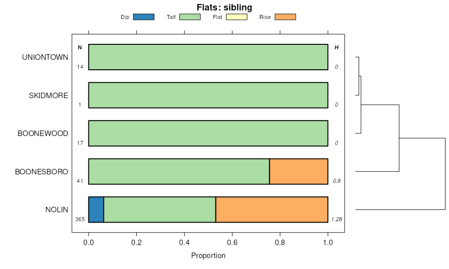
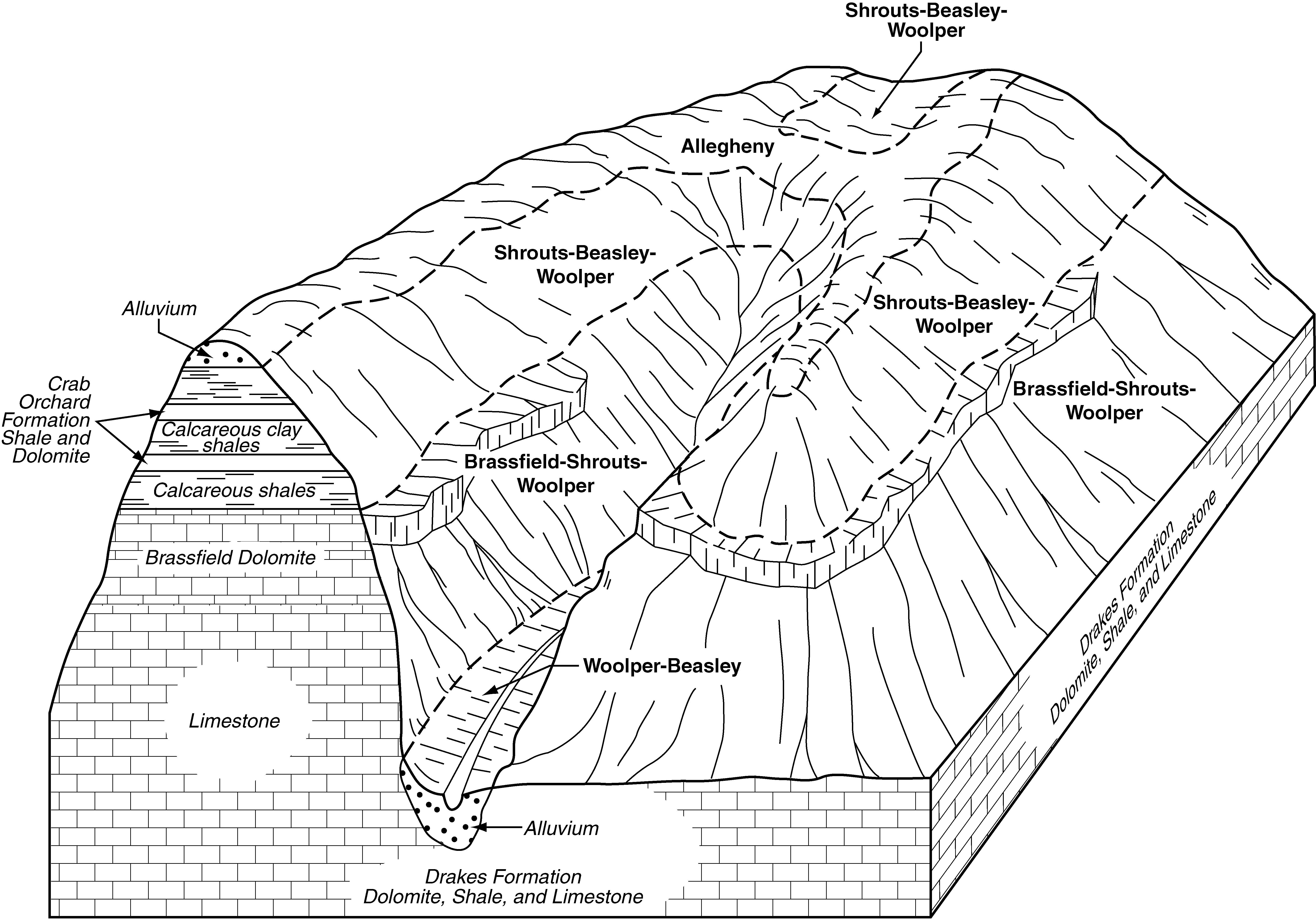
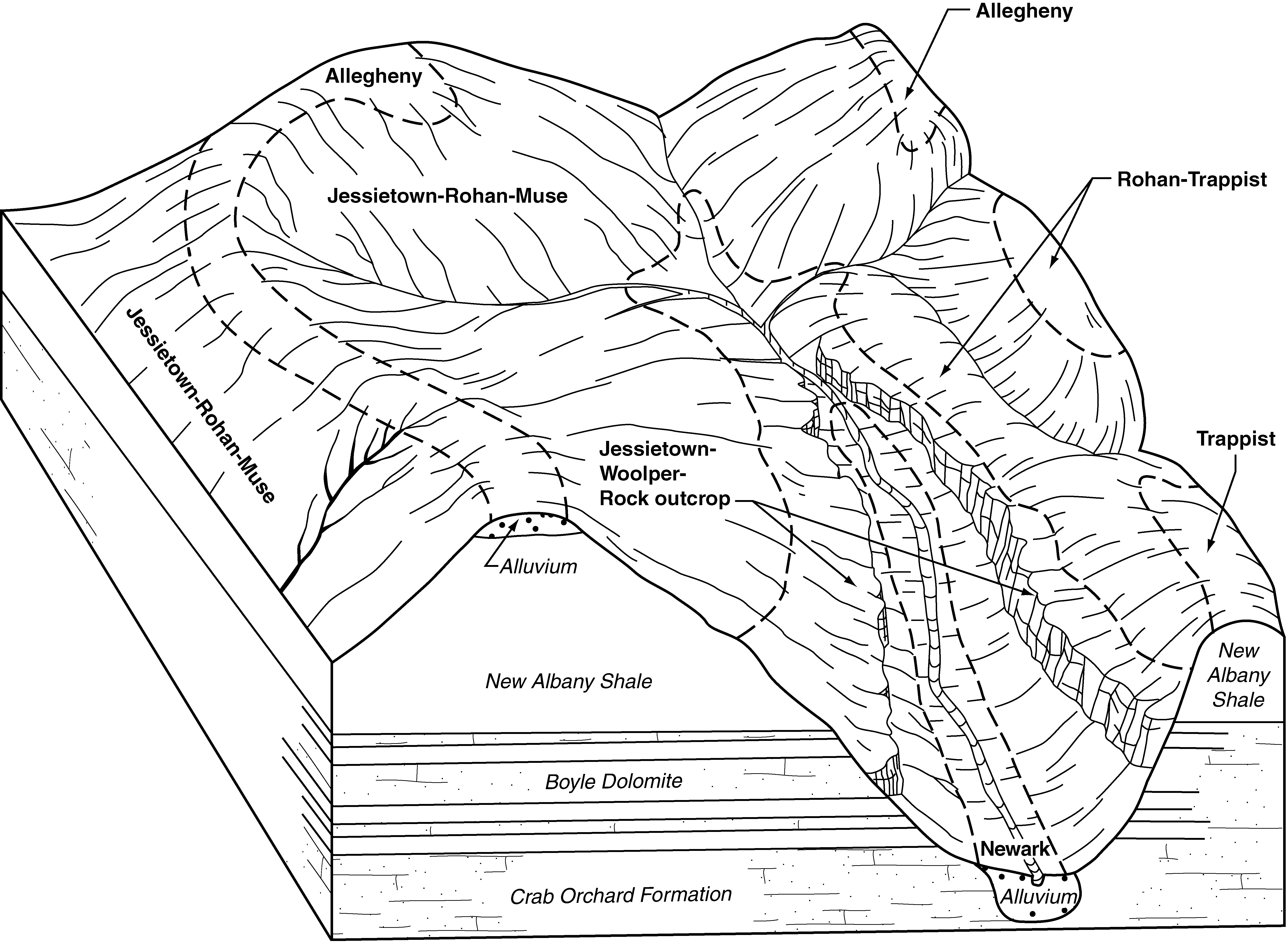
Jessietown-Woolper-Rock outcrop complex, 20 to 50 percent slopes | JwF | 13453 | 557775 | lqdr | ky616 | 2004 | 1:24000 |
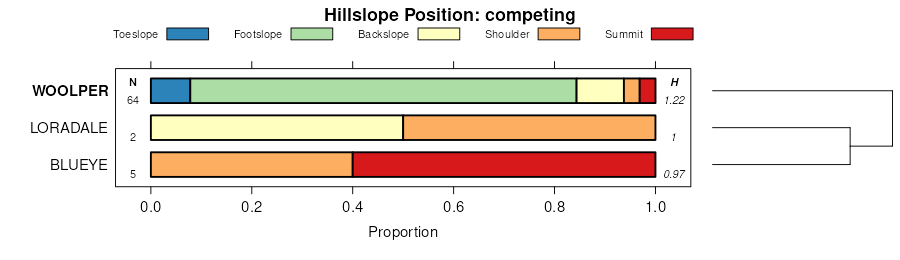
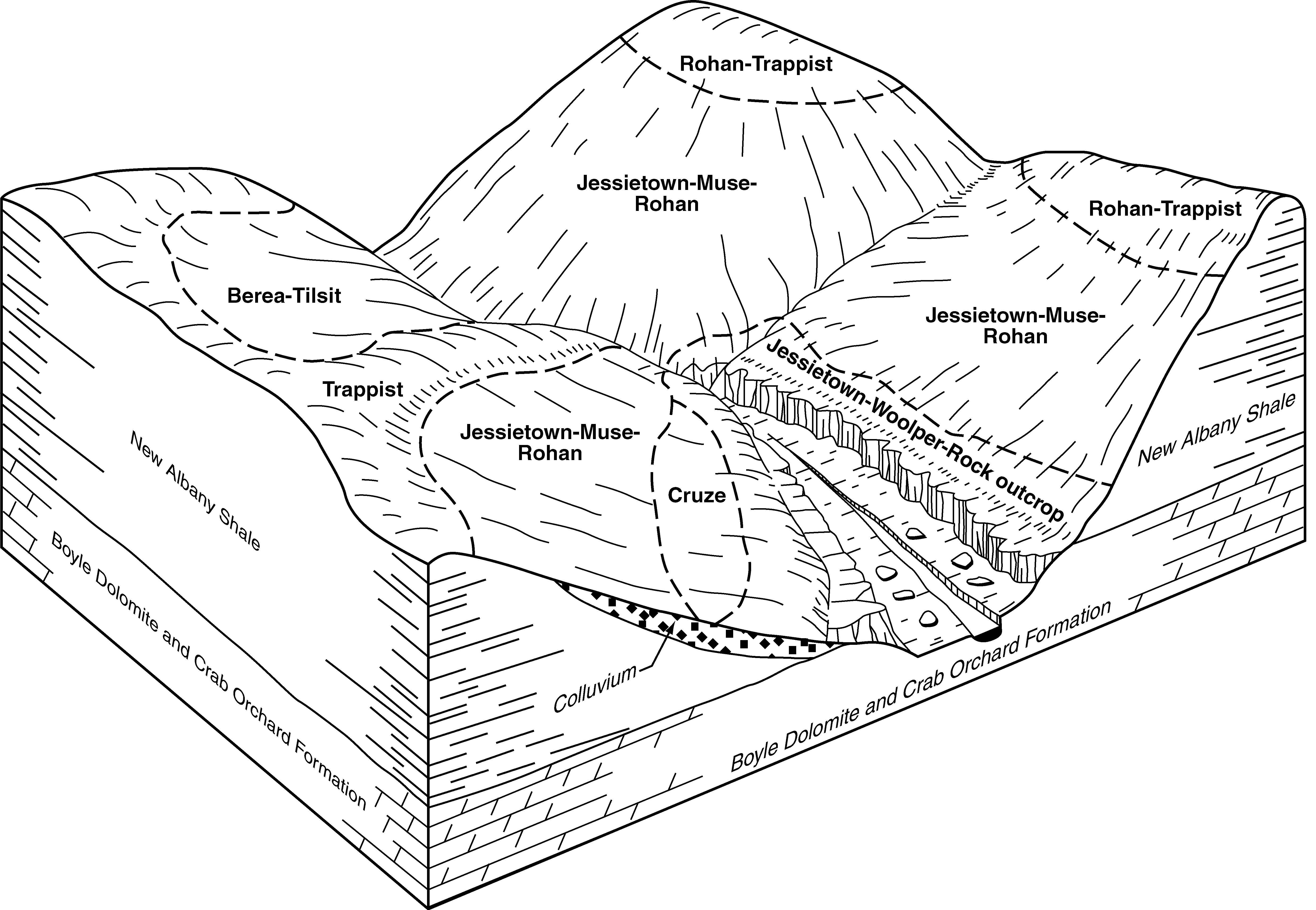
Shrouts-Beasley-Woolper complex, 12 to 30 percent slopes, eroded | SkE2 | 7371 | 557801 | lqfl | ky616 | 2004 | 1:24000 |
Brassfield-Shrouts-Woolper complex, 25 to 75 percent slopes, eroded, stony | BsF2 | 2936 | 557791 | lqf8 | ky616 | 2004 | 1:24000 |
Woolper-Beasley complex, 6 to 15 percent slopes | WoC | 666 | 557808 | lqft | ky616 | 2004 | 1:24000 |
Woolper silty clay loam | Wo | 520 | 551977 | ljcq | ky619 | 1978 | 1:15840 |
Fairmount-Woolper complex, 30 to 65 percent slopes | FwF | 27978 | 551918 | lj9t | ky622 | 1989 | 1:20000 |
Woolper silty clay loam, 6 to 12 percent slopes | WoC | 1097 | 551944 | ljbn | ky622 | 1989 | 1:20000 |
Woolper silty clay loam, 2 to 6 percent slopes | WoB | 1044 | 551943 | ljbm | ky622 | 1989 | 1:20000 |
Woolper silty clay loam, 12 to 20 percent slopes | WoD | 374 | 551945 | ljbp | ky622 | 1989 | 1:20000 |
Shrouts-Woolper complex, 15 to 35 percent slopes | SeE | 1943 | 550851 | lh6d | ky634 | 1989 | 1:20000 |
Woolper silty clay loam, 4 to 12 percent slopes | WoC | 142 | 551862 | lj80 | ky637 | 1989 | 1:12000 |
Sees-Woolper silt loams, 18 to 35 percent slopes | SsE | 1997 | 537818 | l1mz | oh111 | 1968 | 1:15840 |
Sees-Woolper silt loams, 12 to 18 percent slopes | SsD | 505 | 537817 | l1my | oh111 | 1968 | 1:15840 |
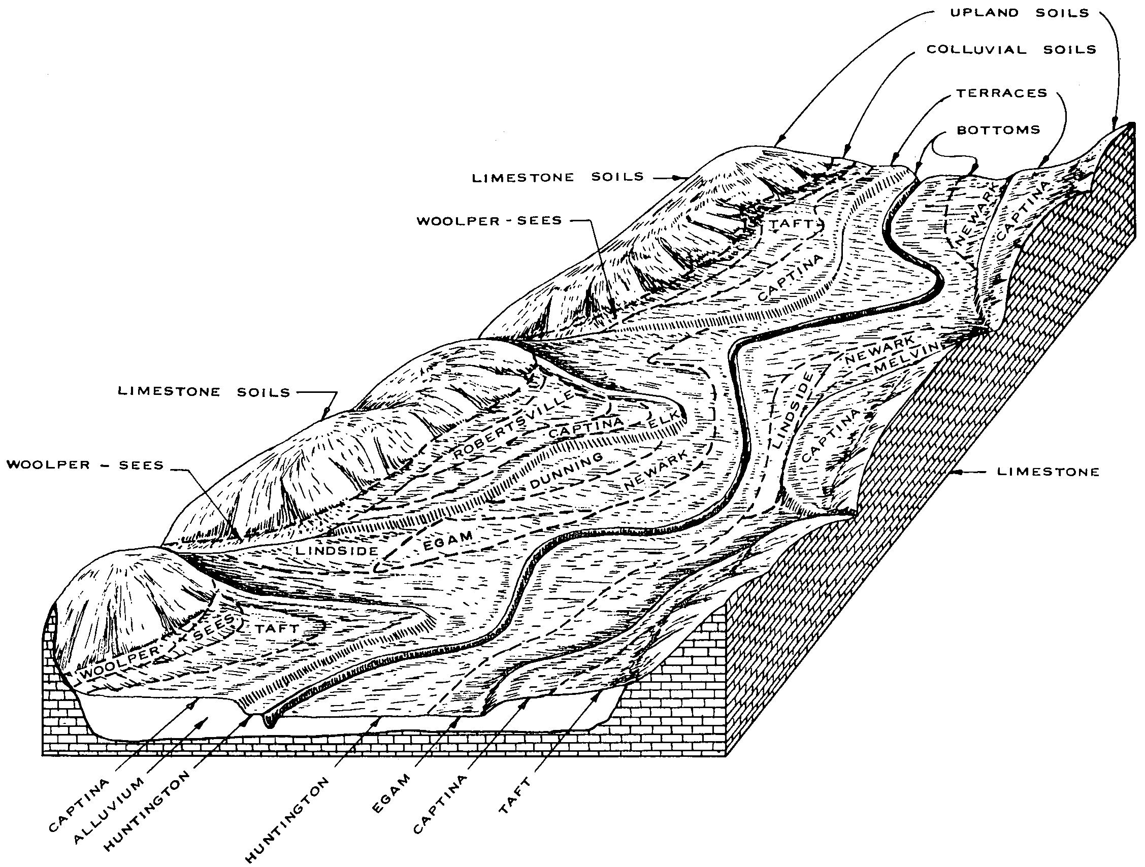
Woolper silt loam, 2 to 6 percent slopes | WxB | 267 | 537837 | l1nl | oh111 | 1968 | 1:15840 |
Woolper and Sees silt loams, 6 to 12 percent slopes | WyC | 124 | 537838 | l1nm | oh111 | 1968 | 1:15840 |
Woolper silty clay loam | Wo | 2041 | 527372 | kps0 | tn055 | 1965 | 1:15840 |