| Wonsqueak muck, 0 to 2 percent slopes | 437 | 1100 | 3395890 | 2ty72 | ct601 | 2003 | 1:12000 |
Wonsqueak muck, 0 to 2 percent slopes | 50A | 1125 | 278967 | 2ty72 | ma011 | 2012 | 1:12000 |
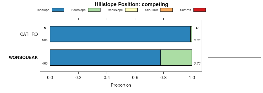
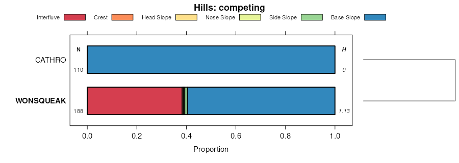
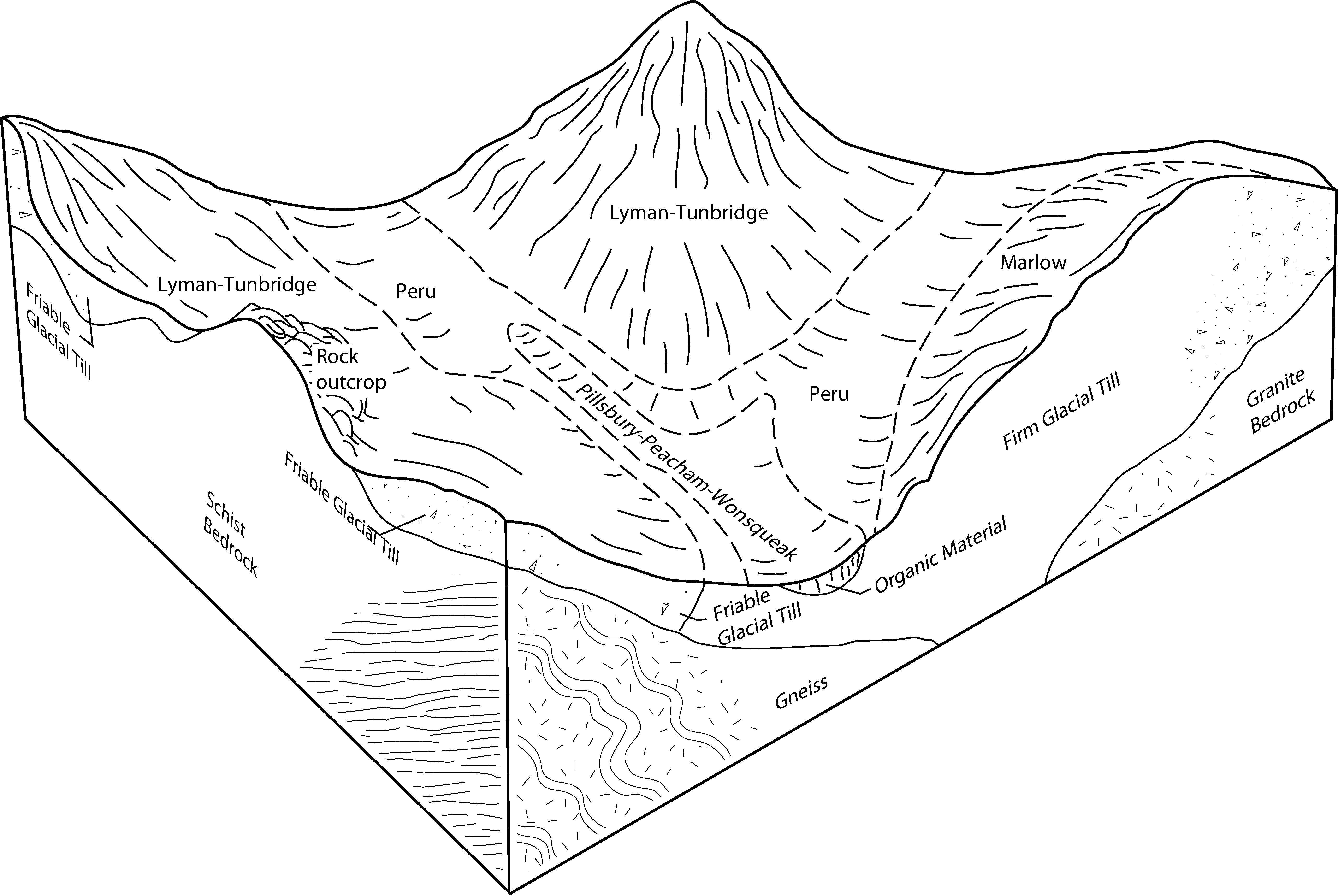
Pillsbury-Peacham-Wonsqueak association, 0 to 8 percent slopes, extremely stony | 922B | 20826 | 277672 | 2trs0 | ma608 | 1989 | 1:25000 |
Pillsbury-Peacham-Wonsqueak association, 0 to 8 percent slopes, extremely stony | 922B | 25 | 1903865 | 2trs0 | ma609 | 1980 | 1:15840 |
Bucksport and Wonsqueak mucks, 0 to 2 percent slopes | 59A | 18996 | 808466 | 2ty70 | ma614 | 1993 | 1:25000 |
Vassalboro-Wonsqueak association | VW | 1377 | 315833 | bln5 | me005 | 1969 | 1:24000 |
Medomak and Wonsqueak soils, frequently flooded | ML | 278 | 315802 | blm5 | me005 | 1969 | 1:24000 |
Wonsqueak and Searsport soils | WS | 237 | 315835 | bln7 | me005 | 1969 | 1:24000 |
Wonsqueak muck, 0 to 2 percent slopes | Wk | 113 | 315834 | 2ty72 | me005 | 1969 | 1:24000 |
Wonsqueak, Bucksport, and Sebago soils | WT | 17704 | 285157 | 9kqm | me611 | 1988 | 1:20000 |
Wonsqueak and Bucksport mucks, 0 to 2 percent slopes | Ws | 11371 | 285160 | 2w9p3 | me611 | 1988 | 1:20000 |
Wonsqueak muck, 0 to 2 percent slopes, frequently flooded | Wo | 4525 | 285159 | 2w9p5 | me611 | 1988 | 1:20000 |
Kinsman-Wonsqueak association | KW | 2852 | 285107 | 9kp0 | me611 | 1988 | 1:20000 |
Bucksport and Wonsqueak mucks, 0 to 2 percent slopes, ponded | BW | 36360 | 741960 | sx26 | me612 | 2016 | 1:24000 |
Medomak-Wonsqueak-Swanville complex, 0 to 3 percent slopes, frequently flooded | MwA | 16574 | 2752432 | 2synn | me612 | 2016 | 1:24000 |
Bucksport and Wonsqueak mucks, 0 to 2 percent slopes, frequently flooded | BWF | 6677 | 741959 | sx25 | me612 | 2016 | 1:24000 |
Swanville-Wonsqueak association, 0 to 3 percent slopes | SwA | 4586 | 1901149 | 21t9d | me612 | 2016 | 1:24000 |
Swanville-Wonsqueak Association, 0 to 3 percent slopes | SQA | 3597 | 746073 | t1bw | me612 | 2016 | 1:24000 |
Kinsman-Wonsqueak complex, 0 to 3 percent slopes | KWA | 2298 | 742158 | sx8l | me612 | 2016 | 1:24000 |
Vassalboro-Wonsqueak association | VW | 14609 | 285843 | 9lfr | me613 | 1987 | 1:20000 |
Medomak and Wonsqueak soils, frequently flooded | ML | 6578 | 285791 | 9ld2 | me613 | 1987 | 1:20000 |
Wonsqueak and Searsport soils | WS | 5348 | 285848 | 9lfx | me613 | 1987 | 1:20000 |
Wonsqueak muck, 0 to 2 percent slopes | Wk | 2859 | 285849 | 2ty72 | me613 | 1987 | 1:20000 |
Bucksport and Wonsqueak mucks, 0 to 2 percent slopes | WB | 29219 | 285376 | 2ty70 | me615 | 1994 | 1:24000 |
Swanville-Wonsqueak association | SW | 6974 | 285364 | 9ky9 | me615 | 1994 | 1:24000 |
Charles-Cornish-Wonsqueak complex | CC | 5765 | 285308 | 9kwh | me615 | 1994 | 1:24000 |
Bucksport and Wonsqueak mucks, 0 to 2 percent slopes | BW | 42499 | 285534 | 2ty70 | me617 | 2004 | 1:24000 |
Wonsqueak and Bucksport mucks, 0 to 2 percent slopes, frequently flooded | WF | 21541 | 285633 | 2ty71 | me617 | 2004 | 1:24000 |
Kinsman-Wonsqueak association, 0 to 3 percent slopes | KW | 13515 | 285580 | 9l58 | me617 | 2004 | 1:24000 |
Medomak and Wonsqueak soils, frequently flooded | MT | 5170 | 285597 | 9l5t | me617 | 2004 | 1:24000 |
Bucksport and Wonsqueak mucks, 0 to 2 percent slopes | WO | 62975 | 285721 | 2ty70 | me619 | 2005 | 1:24000 |
Charles-Cornish-Wonsqueak complex, 0 to 2 percent slopes | CG | 15692 | 285670 | 9l85 | me619 | 2005 | 1:24000 |
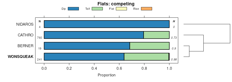
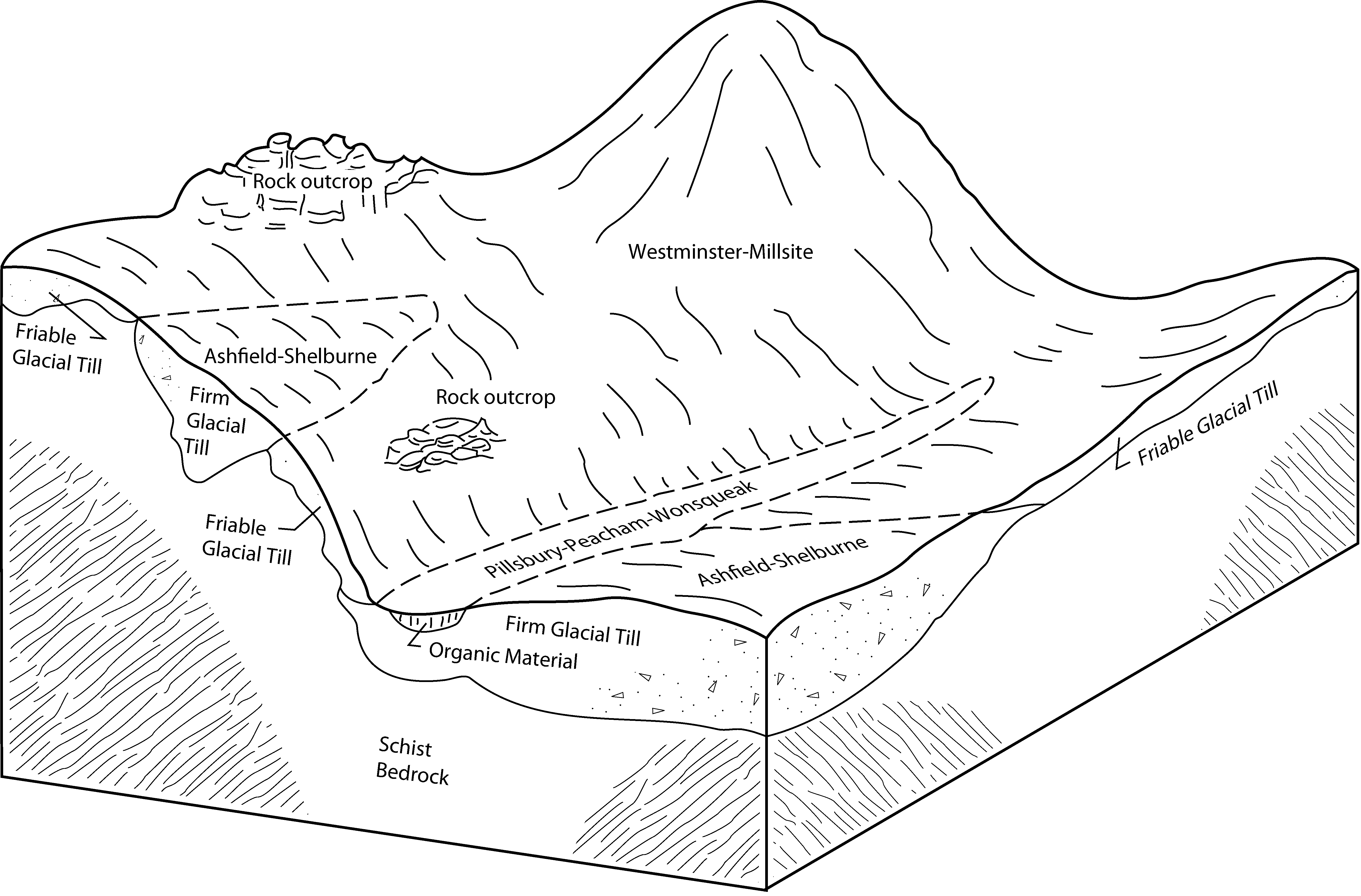
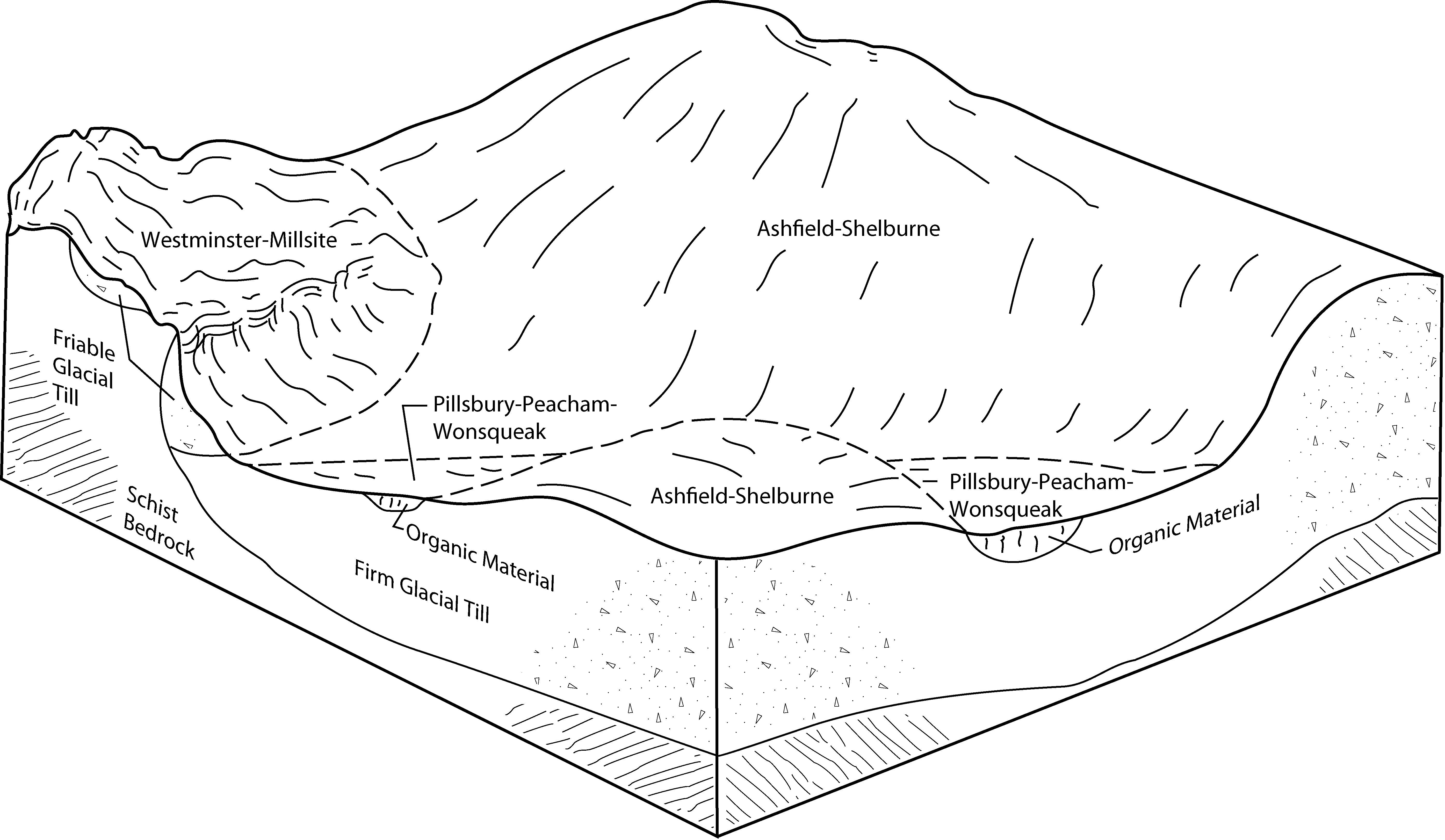
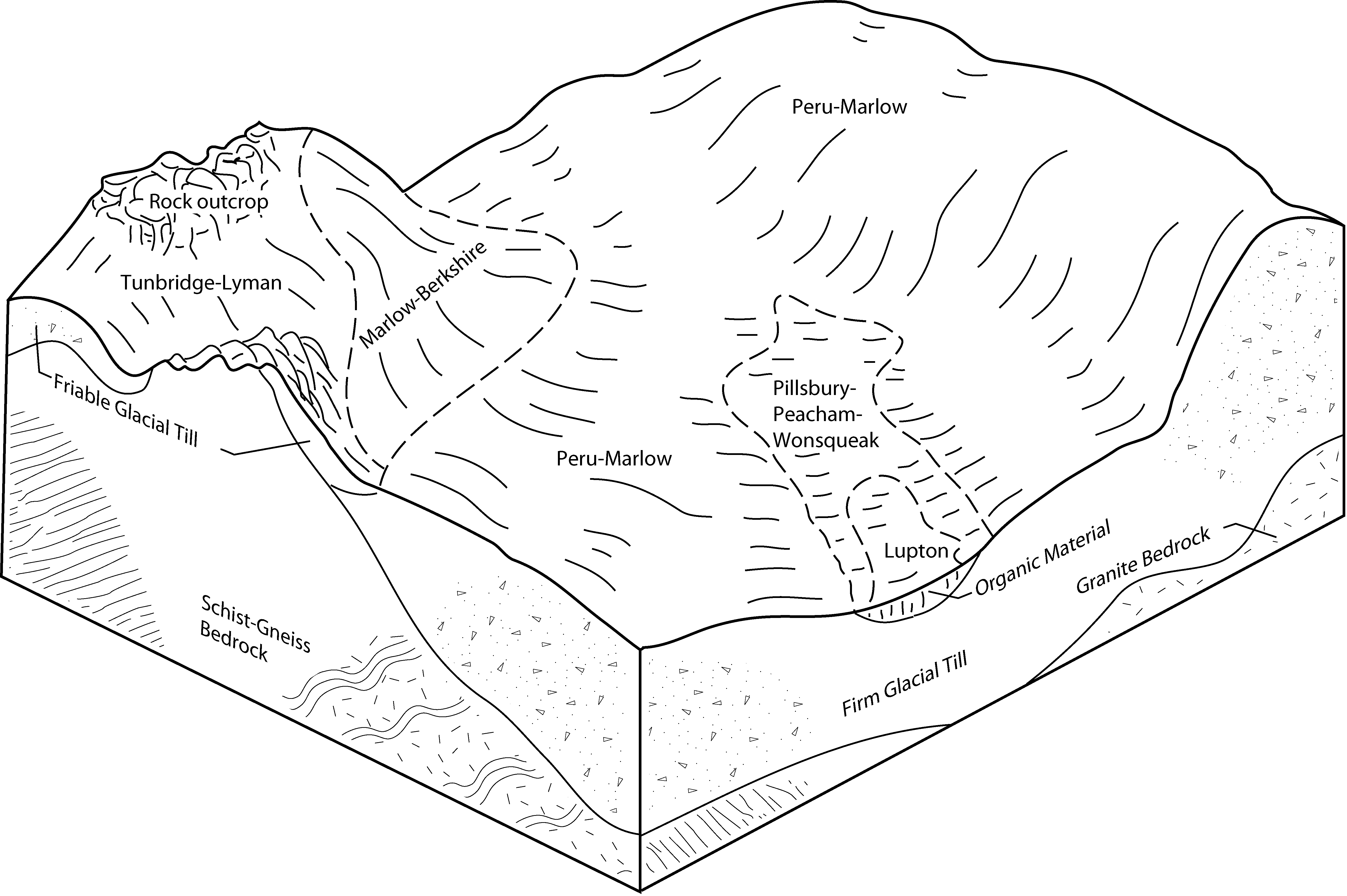
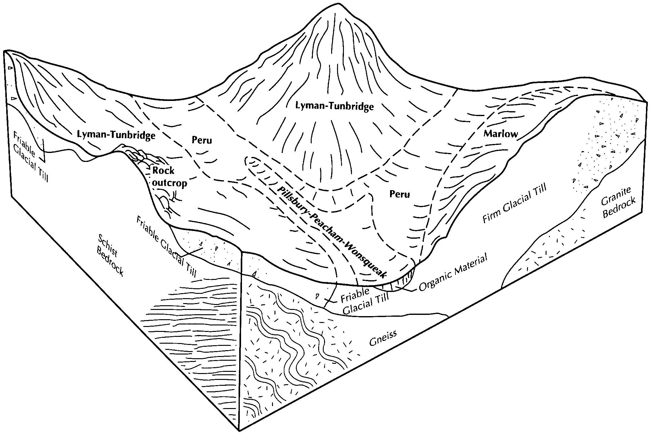
Peacham-Wonsqueak-Cabot association, 0 to 8 percent slopes | PCA | 7 | 1478421 | 1lmf0 | me619 | 2005 | 1:24000 |
Bucksport and Wonsqueak mucks, 0 to 2 percent slopes | WB | 84534 | 2549955 | 2ty70 | me620 | 2011 | 1:24000 |
Wonsqueak and Bucksport mucks, 0 to 2 percent slopes, frequently flooded | WA | 7254 | 2549905 | 2ty71 | me620 | 2011 | 1:24000 |
Roundabout-Wonsqueak association, 0 to 3 percent slopes | RW | 4958 | 2549892 | 2x1f6 | me620 | 2011 | 1:24000 |
Bucksport and Wonsqueak mucks, 0 to 2 percent slopes | WB | 39022 | 2549880 | 2ty70 | me621 | 2011 | 1:24000 |
Wonsqueak and Bucksport mucks, 0 to 2 percent slopes, frequently flooded | WA | 8765 | 2549851 | 2ty71 | me621 | 2011 | 1:24000 |
Roundabout-Wonsqueak association, 0 to 3 percent slopes | RW | 4437 | 2549840 | 2x1f6 | me621 | 2011 | 1:24000 |
Bucksport and Wonsqueak mucks, 0 to 2 percent slopes | BWA | 78437 | 1909309 | 2ty70 | me622 | 2007 | 1:24000 |
Wonsqueak and Bucksport mucks, 0 to 2 percent slopes, frequently flooded | WBA | 8117 | 1909184 | 2ty71 | me622 | 2007 | 1:24000 |
Kinsman-Wonsqueak association, 0 to 3 percent slopes | KOA | 2568 | 1909080 | 222k7 | me622 | 2007 | 1:24000 |
Wonsqueak muck, 0 to 2 percent slopes | 995A | 6035 | 280759 | 2ty72 | nh607 | 2000 | 1:24000 |
Wonsqueak and Pondicherry mucks, 0 to 2 percent slopes | 992A | 3383 | 280766 | 2w9r3 | nh607 | 2000 | 1:24000 |
Peacham-Wonsqueak-Cabot association, nearly level, extremely stony | 768A | 2061 | 280741 | 9f45 | nh607 | 2000 | 1:24000 |
Peacham-Wonsqueak-Pillsbury association, nearly level, extremely stony | 832A | 1945 | 280747 | 9f4c | nh607 | 2000 | 1:24000 |
Vassalboro-Wonsqueak association, nearly level | 950A | 68 | 280758 | 9f4q | nh607 | 2000 | 1:24000 |
Wonsqueak muck | Wu | 4158 | 290258 | 9r15 | ny019 | 1995 | 1:24000 |
Bucksport and Wonsqueak soils | Bw | 726 | 290464 | 9r7t | ny025 | 1999 | 1:24000 |
Wonsqueak muck, 0 to 2 percent slopes | WoA | 870 | 1714433 | 1vk09 | ny031 | 2007 | 1:24000 |
Wonsqueak-Colton-Rumney complex, 0 to 15 percent slopes | 25A | 161 | 2521658 | 9ssk | ny033 | 2018 | 1:24000 |
Wonsqueak-Rumney-Bucksport complex | 26A | 40 | 2521660 | 9ssl | ny033 | 2018 | 1:24000 |
Wonsqueak-Humaquepts complex, 0 to 3 percent slopes, frequently flooded | 1193A | 3363 | 1712749 | 1vh7z | ny035 | 2007 | 1:24000 |
Wonsqueak mucky peat, 0 to 2 percent slopes | 1185A | 1202 | 1712736 | 1vh7k | ny035 | 2007 | 1:24000 |
Wonsqueak-Colton-Rumney complex, 0 to 15 percent slopes | 25A | 683 | 319953 | bqy2 | ny035 | 2007 | 1:24000 |
Searsport-Wonsqueak-Naumburg complex, 0 to 3 percent slopes | 368A | 212 | 1702165 | 1v47k | ny035 | 2007 | 1:24000 |
Wonsqueak-Rumney-Bucksport complex | 26A | 41979 | 291945 | 9ssl | ny041 | 1994 | 1:62500 |
Wonsqueak-Colton-Rumney complex, 0 to 15 percent slopes | 25A | 12340 | 291944 | 9ssk | ny041 | 1994 | 1:62500 |
Bucksport-Wonsqueak complex | 24A | 5810 | 291943 | 9ssj | ny041 | 1994 | 1:62500 |
Bucksport-Wonsqueak complex | 24A | 29 | 2677570 | 9ssj | ny043 | 2018 | 1:24000 |
Wonsqueak-Humaquepts complex, 0 to 3 percent slopes, frequently flooded | 1193A | 8 | 2677587 | 1vh7z | ny043 | 2018 | 1:24000 |
Wonsqueak-Adjidaumo association, 0 to 3 percent slopes, frequently ponded | 9078A | 516 | 964695 | 2w5k7 | ny045 | 1981 | 1:15840 |
Bucksport-Wonsqueak association, 0 to 2 percent slopes, frequently ponded | 9098A | 511 | 964694 | 11cv5 | ny045 | 1981 | 1:15840 |
Wonsqueak-Onjebonge association, 0 to 3 percent slopes, frequently ponded | 9088A | 329 | 964696 | 11cv7 | ny045 | 1981 | 1:15840 |
Endoaquents, disrupted-Wonsqueak-Adjidaumo complex, 0 to 3 percent slopes, frequently ponded | 9028A | 235 | 964700 | 2w5k5 | ny045 | 1981 | 1:15840 |
Bucksport-Wonsqueak-Tughill complex, 0 to 2 percent slopes | 3007A | 5 | 3118082 | 2phbm | ny045 | 1981 | 1:15840 |
Bucksport-Wonsqueak-Tughill complex, 0 to 2 percent slopes | 3007A | 12603 | 2487397 | 2phbm | ny049 | 2018 | 1:24000 |
Wonsqueak-Tughill-Westbury complex, 0 to 3 percent slopes | 3050A | 11856 | 2479286 | 2p6wz | ny049 | 2018 | 1:24000 |
Bucksport-Wonsqueak complex, 0 to 2 percent slopes | 3011A | 3098 | 2504280 | 2pq41 | ny049 | 2018 | 1:24000 |
Wonsqueak mucky peat, 0 to 3 percent slopes | WoA | 493 | 2753734 | 2spms | ny049 | 2018 | 1:24000 |
Wonsqueak-Onjebonge association, 0 to 3 percent slopes, frequently ponded | 9088A | 154 | 2568248 | 11cv7 | ny049 | 2018 | 1:24000 |
Wonsqueak muck | 397 | 1372 | 293419 | 9vb4 | ny065 | 1993 | 1:24000 |
Wonsqueak-Tughill-Westbury complex, 0 to 3 percent slopes | 3050A | 152 | 3118105 | 2p6wz | ny065 | 1993 | 1:24000 |
Bucksport-Wonsqueak-Tughill complex, 0 to 2 percent slopes | 3007A | 18 | 3118104 | 2phbm | ny065 | 1993 | 1:24000 |
Bucksport-Wonsqueak-Tughill complex, 0 to 2 percent slopes | 3007A | 134 | 3118109 | 2phbm | ny075 | 1973 | 1:15840 |
Bucksport-Wonsqueak complex, 0 to 2 percent slopes | 3011A | 20 | 3118110 | 2pq41 | ny075 | 1973 | 1:15840 |
Wonsqueak-Tughill-Westbury complex, 0 to 3 percent slopes | 3050A | 4 | 3118111 | 2p6wz | ny075 | 1973 | 1:15840 |
Wonsqueak muck, ponded | WO | 1873 | 294440 | 9wd2 | ny091 | 1993 | 1:24000 |
Wonsqueak muck | 101 | 29 | 296083 | 9y32 | ny689 | 1999 | 1:24000 |
Wonsqueak and Pondicherry mucks, 0 to 2 percent slopes | 50A | 6285 | 282926 | 2w9r3 | vt005 | 2006 | 1:20000 |
Wonsqueak, Pondicherry, and Bucksport mucks, 0 to 2 percent slopes | SIE8 | 13800 | 2433245 | 2w9r6 | vt009 | 2012 | 1: |
Wonsqueak and Pondicherry mucks, 0 to 2 percent slopes | 83A | 9670 | 283534 | 2w9r3 | vt019 | 2005 | 1:20000 |
Wonsqueak and Pondicherry mucks, 0 to 2 percent slopes | 79A | 2089 | 282760 | 2w9r3 | vt023 | 1996 | 1:20000 |
Wonsqueak and Pondicherry mucks, 0 to 2 percent slopes | 62 | 2921 | 282054 | 2w9r3 | vt025 | 1984 | 1:20000 |
Wonsqueak and Pondicherry mucks, 0 to 2 percent slopes | 47 | 2763 | 283215 | 2w9r3 | vt027 | 2000 | 1:20000 |
Cabot-Pondicherry-Wonsqueak association, 0 to 8 percent slopes, very stony | 403B | 337 | 283344 | 2w9r7 | vt027 | 2000 | 1:20000 |