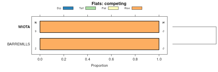
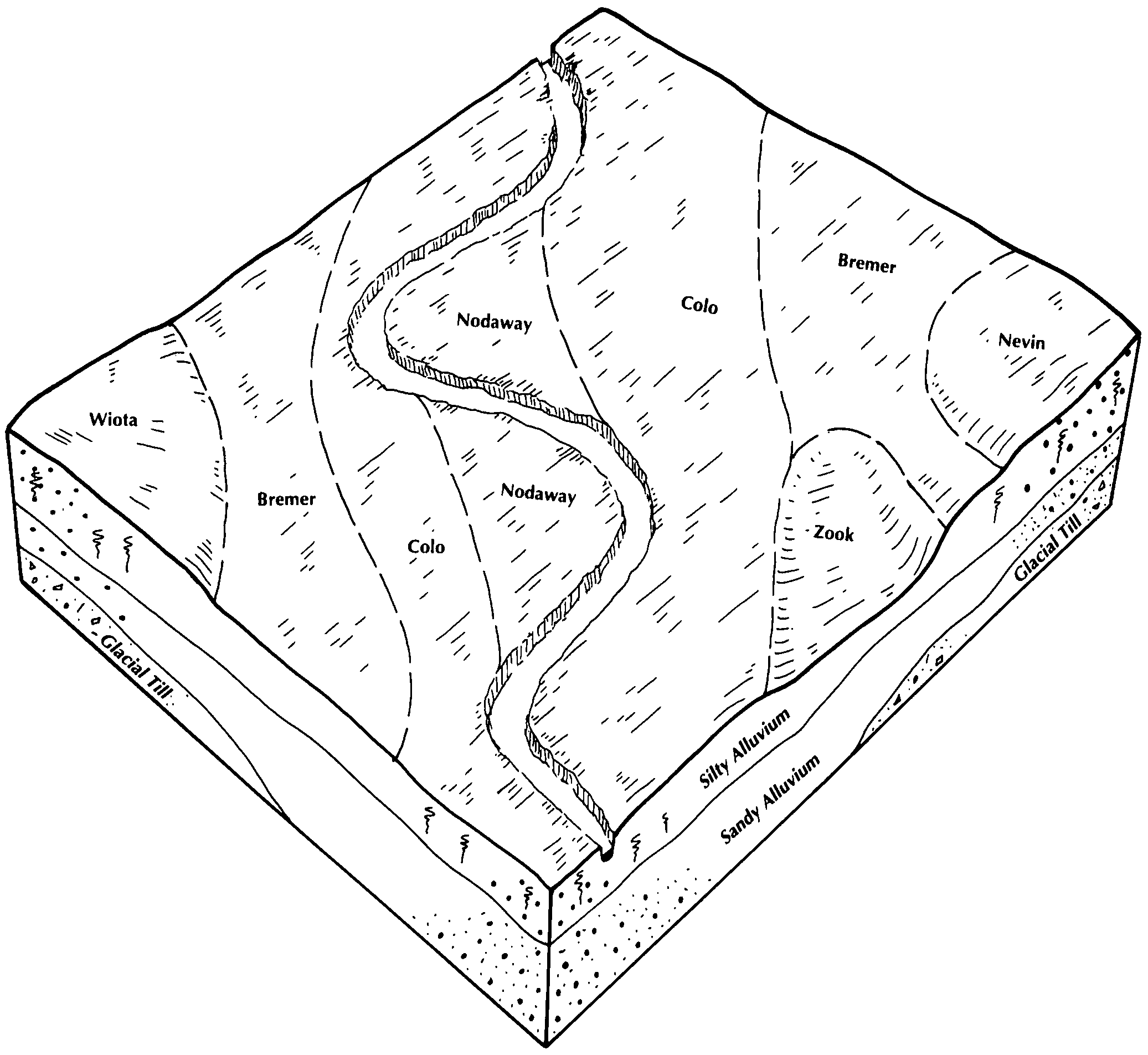
| Wiota silty clay loam, 2 to 5 percent slopes, rarely flooded | 7B | 555 | 1404919 | 1j4xz | ia003 | 2008 | 1:12000 |
Wiota silty clay loam, 0 to 2 percent slopes, rarely flooded | 7 | 209 | 1404918 | 1j4xy | ia003 | 2008 | 1:12000 |
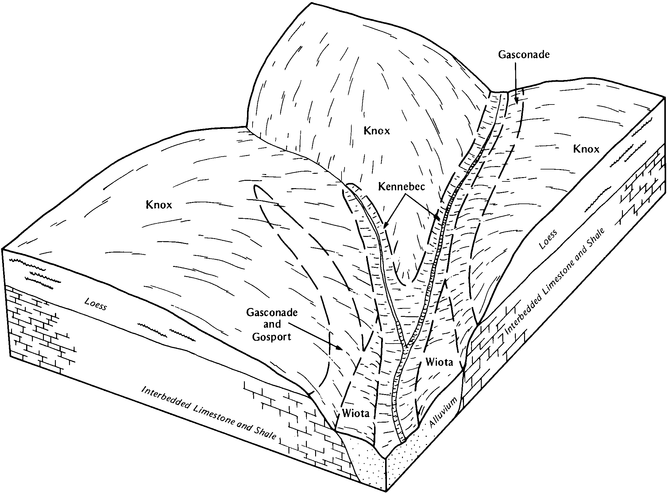
Wiota silt loam, 1 to 3 percent slopes | 7A | 390 | 402730 | fj29 | ia007 | 1970 | 1:15840 |
Wiota silty clay loam, 1 to 4 percent slopes | 7B | 116 | 402784 | fj41 | ia009 | 1982 | 1:15840 |
Wiota silt loam, loamy substratum, 0 to 3 percent slopes, rarely flooded | 127 | 1646 | 402823 | 2y8qs | ia011 | 1977 | 1:15840 |
Wiota silty clay loam, 0 to 2 percent slopes, rarely flooded | 7 | 3086 | 413359 | 2y8qq | ia013 | 2001 | 1:12000 |
Wiota, rarely flooded-Urban land complex, 0 to 2 percent slopes | 4007 | 1154 | 449418 | 2y8qp | ia013 | 2001 | 1:12000 |
Wiota silty clay loam, 0 to 2 percent slopes, rarely flooded | 7 | 413 | 2484807 | 2pdn2 | ia029 | 2010 | 1:12000 |
Wiota silty clay loam, 2 to 5 percent slopes, rarely flooded | 7B | 67 | 1867977 | 20psb | ia029 | 2010 | 1:12000 |
Wiota silt loam, 1 to 3 percent slopes | 7 | 1751 | 404616 | fl14 | ia049 | 1980 | 1:15840 |
Wiota silt loam, 0 to 2 percent slopes, rarely flooded | 7 | 2038 | 406316 | 2y8qt | ia075 | 1973 | 1:15840 |
Wiota silt loam, 0 to 2 percent slopes, rarely flooded | 7 | 510 | 406688 | 2y8qt | ia083 | 1982 | 1:15840 |
Wiota silt loam, 2 to 5 percent slopes, rarely flooded | 7B | 133 | 406697 | 2y8qv | ia083 | 1982 | 1:15840 |
Wiota silty clay loam, 0 to 2 percent slopes, rarely flooded | 7 | 2288 | 453029 | 2y8qq | ia095 | 2005 | 1:12000 |
Wiota silty clay loam, 2 to 5 percent slopes, rarely flooded | 7B | 809 | 1144486 | 2y8qr | ia095 | 2005 | 1:12000 |
Wiota silt loam, 0 to 2 percent slopes, rarely flooded | 7 | 1893 | 407686 | 2y8qt | ia099 | 1975 | 1:15840 |
Wiota silt loam, 0 to 2 percent slopes, rarely flooded | 7 | 659 | 408040 | 2y8qt | ia103 | 1979 | 1:15840 |
Wiota silt loam, sandy substratum, 0 to 2 percent slopes | 127 | 914 | 408713 | fq99 | ia115 | 1984 | 1:15840 |
Wiota silt loam, sandy substratum, 2 to 5 percent slopes | 127B | 736 | 408714 | fq9b | ia115 | 1984 | 1:15840 |
Wiota silt loam, 0 to 2 percent slopes | 7 | 312 | 409268 | fqw6 | ia121 | 1968 | 1:15840 |
Wiota silt loam, 2 to 5 percent slopes | 7B | 215 | 409269 | fqw7 | ia121 | 1968 | 1:15840 |
Wiota silt loam, 0 to 2 percent slopes, rarely flooded | 7 | 682 | 409367 | 2y8qt | ia123 | 1971 | 1:15840 |
Wiota silty clay loam, 0 to 2 percent slopes, rarely flooded | 7 | 1188 | 409509 | 2y8qq | ia127 | 1978 | 1:15840 |
Wiota silty clay loam, 0 to 2 percent slopes | 7 | 2130 | 412970 | fvqm | ia153 | 1993 | 1:12000 |
Wiota silty clay loam, 0 to 2 percent slopes, rarely flooded | 7 | 483 | 410619 | 2y8qq | ia157 | 1978 | 1:15840 |
Wiota silt loam, 0 to 2 percent slopes, rarely flooded | 7 | 6821 | 411536 | 2y8qt | ia171 | 1989 | 1:15840 |
Wiota silt loam, 2 to 5 percent slopes, rarely flooded | 7B | 2564 | 411561 | 2y8qv | ia171 | 1989 | 1:15840 |
Wiota silt loam 1 to 3 percent slopes | 7 | 270 | 411839 | ftk4 | ia179 | 1978 | 1:15840 |
Wiota silt loam, 0 to 2 percent slopes | 7 | 528 | 411961 | ftp2 | ia181 | 1975 | 1:15840 |
Wiota silt loam, 2 to 5 percent slopes | 7B | 386 | 411968 | ftp9 | ia181 | 1975 | 1:15840 |
Wiota silty clay loam, 2 to 5 percent slopes, rarely flooded | 7B | 1116 | 412104 | 2y8qr | ia183 | 1983 | 1:15840 |
Wiota silt loam, 1 to 3 percent slopes, rarely flooded | 12508 | 1409 | 2528302 | 2qmt5 | mo021 | 1984 | 1:24000 |
Wiota silt loam, 0 to 2 percent slopes, rarely flooded | 12506 | 50 | 2528300 | 2qmt4 | mo021 | 1984 | 1:24000 |
Wiota silt loam, 2 to 5 percent slopes, rarely flooded | 64039 | 533 | 885965 | yqxj | mo027 | 1986 | 1:24000 |
Wiota silt loam, 0 to 2 percent slopes | 12505 | 365 | 2528292 | 2qmt3 | mo045 | 1992 | 1:24000 |
Wiota silt loam, 0 to 2 percent slopes | 12505 | 4348 | 2528288 | 2qmt3 | mo047 | 1982 | 1:24000 |
Wiota silt loam, 0 to 2 percent slopes, rarely flooded | 12506 | 20 | 2528294 | 2qmt4 | mo047 | 1982 | 1:24000 |
Wiota silt loam, 0 to 2 percent slopes, rarely flooded | 12506 | 822 | 2528299 | 2qmt4 | mo049 | 1981 | 1:24000 |
Wiota silt loam, 0 to 2 percent slopes | 12505 | 947 | 2528291 | 2qmt3 | mo061 | 1952 | 1:24000 |
Wiota silt loam, 0 to 2 percent slopes | 12505 | 2098 | 2528290 | 2qmt3 | mo063 | 1974 | 1:24000 |
Wiota silt loam, 0 to 2 percent slopes, rarely flooded | 12506 | 950 | 2528298 | 2qmt4 | mo063 | 1974 | 1:24000 |
Wiota silt loam, 0 to 2 percent slopes, rarely flooded | 12506 | 431 | 2528297 | 2qmt4 | mo095 | 1982 | 1:24000 |
Wiota silt loam, 1 to 4 percent slopes, rarely flooded | 12510 | 177 | 2579894 | 2qs0z | mo095 | 1982 | 1:24000 |
Wiota silty clay loam, 0 to 2 percent slopes | 12507 | 712 | 887661 | ysp7 | mo147 | 1983 | 1:24000 |
Wiota silt loam, 0 to 2 percent slopes, rarely flooded | 12506 | 3988 | 2528296 | 2qmt4 | mo165 | 1982 | 1:24000 |
Wiota silt loam, 1 to 4 percent slopes, rarely flooded | 12510 | 267 | 2544454 | 2qs0z | mo165 | 1982 | 1:24000 |
Wiota silt loam, 0 to 2 percent slopes | 12505 | 80 | 2528289 | 2qmt3 | mo165 | 1982 | 1:24000 |
Wiota silt loam, 1 to 3 percent slopes, rarely flooded | 12508 | 11 | 2528301 | 2qmt5 | mo165 | 1982 | 1:24000 |
Wiota silt loam, 0 to 2 percent slopes | 12505 | 1422 | 2528287 | 2qmt3 | mo177 | 1979 | 1:24000 |
Wiota silt loam, 0 to 2 percent slopes, rarely flooded | 12506 | 2 | 2528293 | 2qmt4 | mo177 | 1979 | 1:24000 |
Wiota silt loam, 0 to 2 percent slopes, rarely flooded | 12506 | 319 | 2528295 | 2qmt4 | mo195 | 1989 | 1:24000 |

