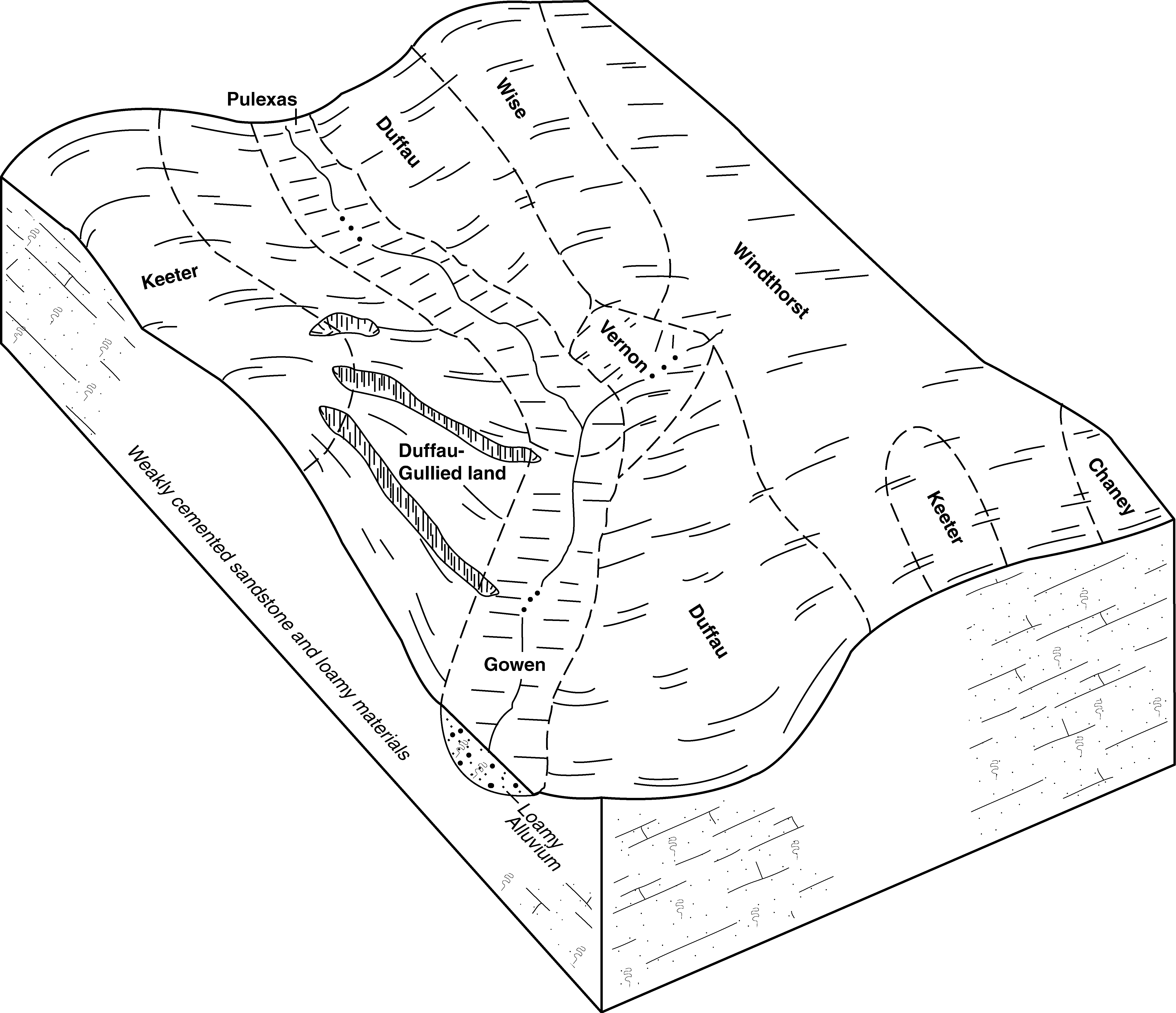
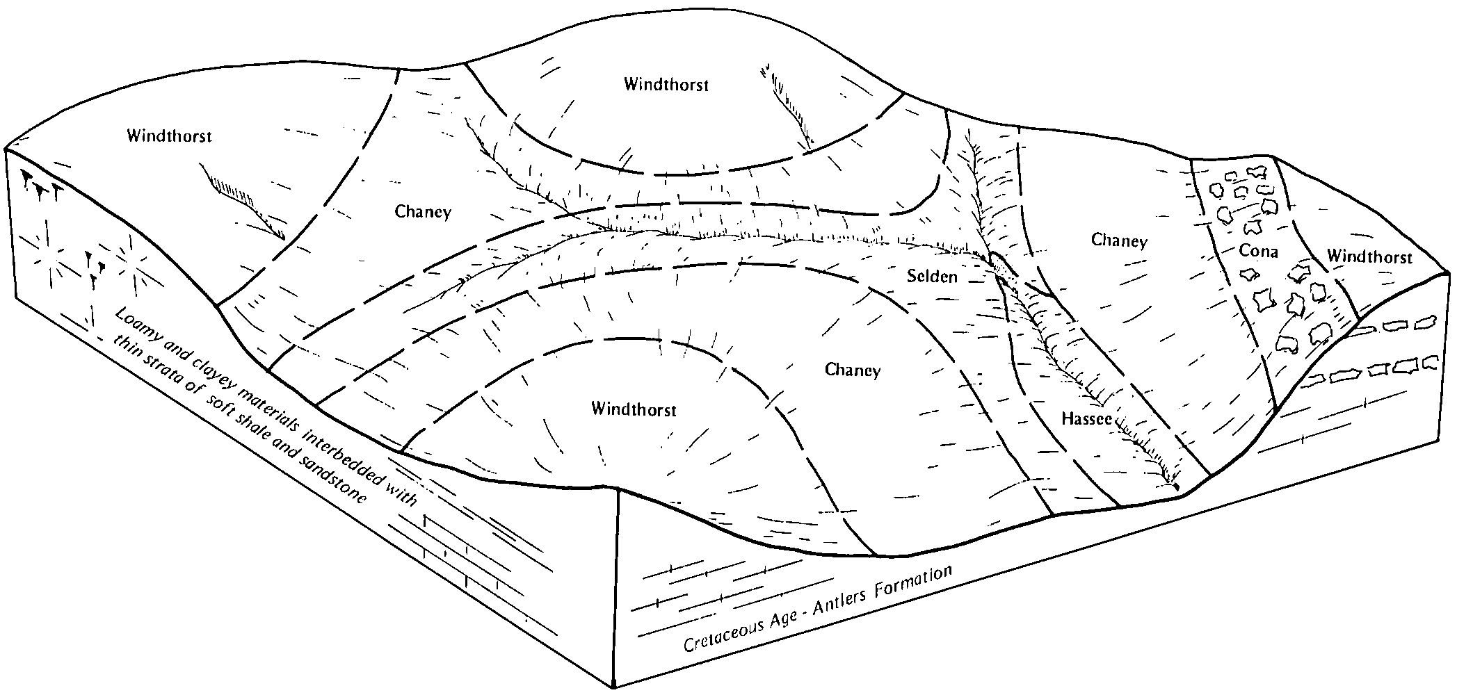
| Windthorst-Weatherford complex, 5 to 12 percent slopes | 55 | 77136 | 382041 | 2sz2w | ok019 | 1977 | 1:24000 |
Windthorst fine sandy loam, 3 to 8 percent slopes, eroded | 53 | 24100 | 382039 | 2tc3w | ok019 | 1977 | 1:24000 |
Windthorst fine sandy loam, 3 to 5 percent slopes | 52 | 14261 | 382038 | 2tc3t | ok019 | 1977 | 1:24000 |
Windthorst very fine sandy loam, 1 to 3 percent slopes | 51 | 9677 | 382037 | 2tc3q | ok019 | 1977 | 1:24000 |
Windthorst-Darnell-Rock outcrop complex, 5 to 25 percent slopes | 54 | 9460 | 382040 | 2tc3z | ok019 | 1977 | 1:24000 |
Windthorst sandy loam, 3 to 5 percent slopes | WhC | 4518 | 382214 | 30kzr | ok031 | 1965 | 1:24000 |
Windthorst sandy loam, 1 to 3 percent slopes | WhB | 3025 | 382213 | 30kzq | ok031 | 1965 | 1:24000 |
Windthorst-Weatherford complex, 5 to 12 percent slopes | WsD | 26917 | 383761 | 2sz2w | ok085 | 1963 | 1:24000 |
Weatherford-Windthorst-Konsil complex, 1 to 8 percent slopes, severely eroded | Sw3 | 22261 | 383744 | dw9v | ok085 | 1963 | 1:24000 |
Windthorst-Darnell-Rock outcrop complex, 5 to 25 percent slopes | Wn | 5934 | 383760 | 2tc3z | ok085 | 1963 | 1:24000 |
Windthorst fine sandy loam, 1 to 5 percent slopes | WdC | 2780 | 383758 | 2tc3r | ok085 | 1963 | 1:24000 |
Windthorst fine sandy loam, 1 to 5 percent slopes, eroded | WdC2 | 1703 | 383759 | 2tc3s | ok085 | 1963 | 1:24000 |
Windthorst fine sandy loam, 1 to 5 percent slopes, moderately eroded | WoB2 | 5778 | 363031 | 2zht3 | tx035 | 1977 | 1:24000 |
Hico and Windthorst sandy clay loams, 1 to 8 percent slopes, severely eroded | HwD3 | 4065 | 363032 | 2zhsz | tx035 | 1977 | 1:24000 |
Windthorst very fine sandy loam, 1 to 5 percent slopes | WoB | 2906 | 363029 | 2zht2 | tx035 | 1977 | 1:24000 |
Windthorst very fine sandy loam, 1 to 5 percent slopes | WoB | 2599 | 3221186 | 2zht2 | tx093 | 1974 | 1:20000 |
Hico and Windthorst sandy clay loams, 1 to 8 percent slopes, severely eroded | HwD3 | 1987 | 3221185 | 2zhsz | tx093 | 1974 | 1:20000 |
Windthorst fine sandy loam, 1 to 5 percent slopes, moderately eroded | WoB2 | 29 | 3221187 | 2zht3 | tx093 | 1974 | 1:20000 |
Windthorst and Duffau soils, 2 to 8 percent slopes, severely eroded | 21 | 4346 | 364469 | 2tc22 | tx097 | 1973 | 1:24000 |
Duffau-Windthorst complex, 1 to 5 percent slopes, moderately eroded | 19 | 3989 | 364466 | 2xmd9 | tx097 | 1973 | 1:24000 |
Windthorst fine sandy loam, 5 to 8 percent slopes | 83 | 3366 | 364537 | 2tc3v | tx097 | 1973 | 1:24000 |
Windthorst fine sandy loam, 1 to 5 percent slopes | 82 | 2661 | 364536 | 2tc3r | tx097 | 1973 | 1:24000 |
Windthorst loamy fine sand, 5 to 8 percent slopes | 81 | 957 | 364535 | d7b6 | tx097 | 1973 | 1:24000 |
Windthorst loamy fine sand, 1 to 5 percent slopes | 80 | 676 | 364534 | 2tc3x | tx097 | 1973 | 1:24000 |
Windthorst very fine sandy loam, 1 to 5 percent slopes | WoB | 987 | 3221198 | 2zht2 | tx133 | 1972 | 1:20000 |
Hico and Windthorst sandy clay loams, 1 to 8 percent slopes, severely eroded | HwD3 | 784 | 3221196 | 2zhsz | tx133 | 1972 | 1:20000 |
Windthorst fine sandy loam, 1 to 5 percent slopes | WnBC | 332 | 3221197 | 2zht1 | tx133 | 1972 | 1:20000 |
Windthorst fine sandy loam, 1 to 5 percent slopes, moderately eroded | WoB2 | 31643 | 365418 | 2zht3 | tx143 | 1966 | 1:20000 |
Hico and Windthorst sandy clay loams, 1 to 8 percent slopes, severely eroded | HwD3 | 24750 | 365371 | 2zhsz | tx143 | 1966 | 1:20000 |
Windthorst loamy fine sand, 1 to 5 percent slopes | WnC | 16664 | 365416 | 2tc3x | tx143 | 1966 | 1:20000 |
Windthorst very fine sandy loam, 1 to 5 percent slopes | WoB | 15882 | 365417 | 2zht2 | tx143 | 1966 | 1:20000 |
Windthorst and Duffau sandy clay loams, 1 to 8 percent slopes, severely eroded | WnD3 | 11270 | 365422 | 2zht0 | tx143 | 1966 | 1:20000 |
Windthorst fine sandy loam, 1 to 5 percent slopes | WnBC | 1469 | 365419 | 2zht1 | tx143 | 1966 | 1:20000 |
Windthorst fine sandy loam, 1 to 5 percent slopes, eroded | WdC3 | 20042 | 366884 | d9rz | tx187 | 1973 | 1:20000 |
Windthorst fine sandy loam, 1 to 3 percent slopes | WdB | 2551 | 366883 | d9ry | tx187 | 1973 | 1:20000 |
Windthorst fine sandy loam, 1 to 5 percent slopes, moderately eroded | WoB2 | 3580 | 376672 | 2zht3 | tx193 | 1994 | 1:24000 |
Windthorst very fine sandy loam, 1 to 5 percent slopes | WoB | 3513 | 376671 | 2zht2 | tx193 | 1994 | 1:24000 |
Hico and Windthorst sandy clay loams, 1 to 8 percent slopes, severely eroded | HwD3 | 453 | 3221223 | 2zhsz | tx193 | 1994 | 1:24000 |
Windthorst fine sandy loam, 1 to 5 percent slopes | WnBC | 9169 | 368068 | 2zht1 | tx237 | 1992 | 1:24000 |
Windthorst and Duffau soils, 2 to 8 percent slopes, severely eroded | 45 | 45775 | 370792 | 2tc22 | tx337 | 1975 | 1:24000 |
Windthorst fine sandy loam, 1 to 5 percent slopes | 43 | 39863 | 370790 | 2tc3r | tx337 | 1975 | 1:24000 |
Windthorst fine sandy loam, 5 to 8 percent slopes | 44 | 33162 | 370791 | 2tc3v | tx337 | 1975 | 1:24000 |
Duffau-Windthorst complex, 1 to 5 percent slopes, moderately eroded | 15 | 19153 | 370759 | 2xmd9 | tx337 | 1975 | 1:24000 |
Windthorst loamy fine sand, 1 to 5 percent slopes | 42 | 8060 | 370789 | 2tc3x | tx337 | 1975 | 1:24000 |
Windthorst fine sandy loam, 1 to 5 percent slopes | WnBC | 3764 | 390979 | 2zht1 | tx363 | 1979 | 1:24000 |
Windthorst fine sandy loam, 1 to 5 percent slopes, moderately eroded | WoB2 | 7 | 3221231 | 2zht3 | tx363 | 1979 | 1:24000 |
Windthorst fine sandy loam, 1 to 5 percent slopes, moderately eroded | WoB2 | 40374 | 390921 | 2zht3 | tx367 | 1973 | 1:20000 |
Duffau-Windthorst complex, 1 to 5 percent slopes, moderately eroded | DwC2 | 24416 | 390876 | 2xmd9 | tx367 | 1973 | 1:20000 |
Windthorst and Duffau sandy clay loams, 1 to 8 percent slopes, severely eroded | WnD3 | 11866 | 390924 | 2zht0 | tx367 | 1973 | 1:20000 |
Windthorst loamy fine sand, 1 to 5 percent slopes | WnC | 7724 | 390918 | 2tc3x | tx367 | 1973 | 1:20000 |
Windthorst fine sandy loam, 1 to 5 percent slopes | WnBC | 5498 | 390920 | 2zht1 | tx367 | 1973 | 1:20000 |
Windthorst very fine sandy loam, 1 to 5 percent slopes | WoB | 4264 | 390919 | 2zht2 | tx367 | 1973 | 1:20000 |
Windthorst-Urban land complex, 2 to 8 percent slopes | WuD | 515 | 390923 | 2xmf9 | tx367 | 1973 | 1:20000 |
Hico and Windthorst sandy clay loams, 1 to 8 percent slopes, severely eroded | HwD3 | 208 | 3221245 | 2zhsz | tx367 | 1973 | 1:20000 |
Windthorst very fine sandy loam, 1 to 5 percent slopes | WoB | 1136 | 372437 | 2zht2 | tx439 | 1979 | 1:20000 |
Duffau-Windthorst complex, 1 to 5 percent slopes, moderately eroded | DwC2 | 497 | 3054445 | 2xmd9 | tx439 | 1979 | 1:20000 |
Windthorst fine sandy loam, 1 to 5 percent slopes, moderately eroded | WoB2 | 124 | 372439 | 2zht3 | tx439 | 1979 | 1:20000 |
Windthorst fine sandy loam, 1 to 5 percent slopes | WtC | 21779 | 373704 | 2tc3r | tx497 | 1984 | 1:20000 |
Duffau-Windthorst complex, 1 to 5 percent slopes, moderately eroded | WeC | 12821 | 373701 | 2xmd9 | tx497 | 1984 | 1:20000 |
Windthorst fine sandy loam, 3 to 8 percent slopes, eroded | WtC3 | 10879 | 373705 | 2tc3w | tx497 | 1984 | 1:20000 |
Windthorst and Duffau sandy clay loams, 1 to 8 percent slopes, severely eroded | WnD3 | 577 | 3221255 | 2zht0 | tx497 | 1984 | 1:20000 |
Windthorst fine sandy loam, 1 to 5 percent slopes, moderately eroded | WoB2 | 21333 | 374371 | 2zht3 | tx609 | 1975 | 1:20000 |
Windthorst and Duffau sandy clay loams, 1 to 8 percent slopes, severely eroded | WnD3 | 8346 | 374373 | 2zht0 | tx609 | 1975 | 1:20000 |
Windthorst very fine sandy loam, 1 to 5 percent slopes | WoB | 7236 | 374369 | 2zht2 | tx609 | 1975 | 1:20000 |
Windthorst loamy fine sand, 1 to 5 percent slopes | WnC | 4689 | 374368 | 2tc3x | tx609 | 1975 | 1:20000 |
Windthorst fine sandy loam, 1 to 5 percent slopes | WnBC | 952 | 374370 | 2zht1 | tx609 | 1975 | 1:20000 |
Duffau-Windthorst complex, 1 to 5 percent slopes, moderately eroded | DwC2 | 943 | 374334 | 2xmd9 | tx609 | 1975 | 1:20000 |
Hico and Windthorst sandy clay loams, 1 to 8 percent slopes, severely eroded | HwD3 | 240 | 374372 | 2zhsz | tx609 | 1975 | 1:20000 |


