| Wilcox-Boswell complex, 5 to 15 percent slopes, eroded | WwD2 | 690 | 2247757 | 2ffz9 | al007 | 2007 | 1:24000 |
Wilcox clay loam, 2 to 5 percent slopes, eroded | WiB2 | 130 | 2247755 | 2ffz7 | al007 | 2007 | 1:24000 |
Wilcox silty clay, 5 to 15 percent slopes, eroded | WcD2 | 1890 | 328575 | c0x6 | al023 | 1998 | 1:24000 |
Wilcox silty clay, 1 to 5 percent slopes | WcB | 900 | 328574 | c0x5 | al023 | 1998 | 1:24000 |
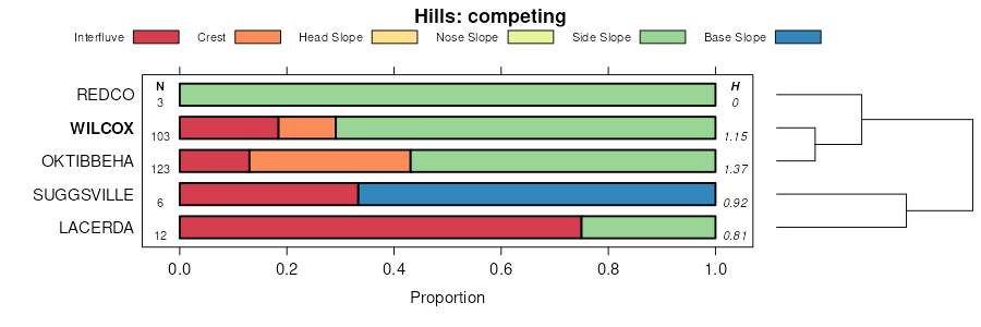
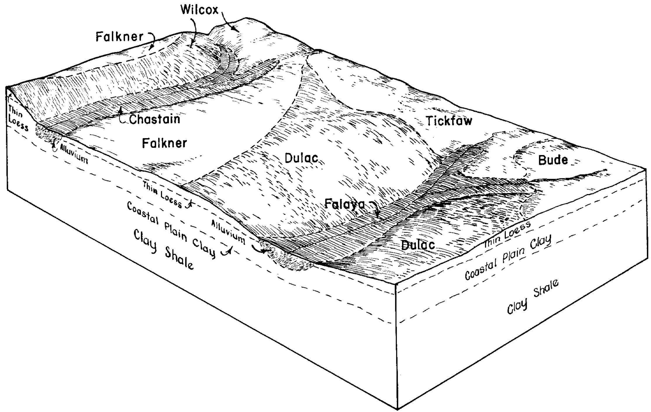
Wilcox clay, 1 to 5 percent slopes | WxB | 27150 | 330608 | 2svnm | al091 | 1997 | 1:24000 |
Wilcox clay, 5 to 15 percent slopes, eroded | WxD2 | 14110 | 330609 | c30t | al091 | 1997 | 1:24000 |
Wilcox clay loam, eroded, nearly level phase | WfB2 | 1025 | 331018 | c3g0 | al101 | 1958 | 1:20000 |
Wilcox clay loam, level phase | WfA | 250 | 331017 | c3fz | al101 | 1958 | 1:20000 |
Wilcox silty clay, 2 to 5 percent slopes | WcB | 51650 | 331500 | c3yk | al119 | 1986 | 1:24000 |
Wilcox-Luverne complex, 5 to 8 percent slopes, eroded | WuC2 | 8795 | 331501 | c3yl | al119 | 1986 | 1:24000 |
Wilcox clay, 5 to 15 percent slopes, eroded | WcD2 | 5810 | 331684 | c44h | al131 | 1997 | 1:24000 |
Wilcox clay, 1 to 5 percent slopes | WcB | 4440 | 331683 | 2svnm | al131 | 1997 | 1:24000 |
Wilcox silty clay loam, level phase | WcA | 4576 | 565207 | lz4h | ar011 | 1959 | 1:20000 |
Wilcox silty clay loam, moderately steep phase | WcE | 4074 | 565211 | lz4m | ar011 | 1959 | 1:20000 |
Wilcox silty clay loam, steep phase | WcF | 3929 | 565212 | lz4n | ar011 | 1959 | 1:20000 |
Wilcox silty clay loam, nearly level phase | WcB | 2524 | 565208 | lz4j | ar011 | 1959 | 1:20000 |
Wilcox silty clay loam, gently sloping phase | WcC | 2065 | 565209 | lz4k | ar011 | 1959 | 1:20000 |
Wilcox silty clay loam, eroded gently sloping phase | WcC2 | 585 | 565210 | lz4l | ar011 | 1959 | 1:20000 |
Wilcox silt loam, 1 to 3 percent slopes | 90 | 5768 | 3179429 | lypw | ar019 | 1983 | 1:20000 |
Wilcox silt loam, 3 to 8 percent slopes | 91 | 4807 | 3179430 | lypx | ar019 | 1983 | 1:20000 |
Wilcox silty clay loam, 1 to 8 percent slopes | 21C | 2460 | 1715890 | 1vlj9 | ar053 | 2006 | 1:24000 |
Wilcox silty clay loam, 8 to 15 percent slopes | 21D | 980 | 1715891 | 1vljb | ar053 | 2006 | 1:24000 |
Wilcox silty clay loam, 1 to 8 percent slopes | WxC | 9007 | 721491 | s6rx | ar099 | 2000 | 1:24000 |
Wilcox silty clay loam, 8 to 15 percent slopes | WxD | 2935 | 721492 | s6ry | ar099 | 2000 | 1:24000 |
Wilcox silty clay loam, 5 to 8 percent slopes, moderately eroded | WcC2 | 1748 | 331866 | 30wc8 | ms013 | 1963 | 1:15840 |
Wilcox silty clay loam, 8 to 15 percent slopes, moderately eroded | WcD3 | 1308 | 331868 | 30wcb | ms013 | 1963 | 1:15840 |
Wilcox silty clay loam, 2 to 5 percent slopes, moderately eroded | WcB2 | 534 | 331864 | 30wc0 | ms013 | 1963 | 1:15840 |
Wilcox silty clay loam, 8 to 15 percent slopes, moderately eroded | WlE2 | 6885 | 331918 | 30wcb | ms017 | 1969 | 1:20000 |
Wilcox silty clay loam, 5 to 8 percent slopes, moderately eroded | WlC | 5065 | 331917 | 30wc8 | ms017 | 1969 | 1:20000 |
Wilcox silty clay loam, 2 to 5 percent slopes, moderately eroded | WcB | 1712 | 331916 | 30wc0 | ms017 | 1969 | 1:20000 |
Wilcox silt loam, 8 to 17 percent slopes | WcD | 3755 | 332117 | c4lg | ms025 | 1974 | 1:20000 |
Wilcox silt loam, 5 to 8 percent slopes | WcC | 2150 | 332116 | c4lf | ms025 | 1974 | 1:20000 |
Wilcox silt loam, 2 to 5 percent slopes | WcB | 2137 | 332115 | c4ld | ms025 | 1974 | 1:20000 |
Wilcox silty clay loam, 1 to 3 percent slopes | WO | 39375 | 332803 | 301jw | ms069 | 1991 | 1:20000 |
Wilcox-Sweatman association, 8 to 17 percent slopes, severely eroded | WS | 14346 | 332804 | 301jy | ms069 | 1991 | 1:20000 |
Wilcox silty clay loam, 2 to 5 percent slopes | WcB | 4359 | 332806 | 301jv | ms069 | 1991 | 1:20000 |
Wilcox silty clay loam, 5 to 8 percent slopes, moderately eroded | WcC2 | 2355 | 332807 | 2shtq | ms069 | 1991 | 1:20000 |
Wilcox silty clay loam, 1 to 2 percent slopes | WcA | 1653 | 332805 | c59n | ms069 | 1991 | 1:20000 |
Wilcox silty clay loam, 8 to 17 percent slopes, severely eroded | WcE2 | 950 | 332808 | 301jx | ms069 | 1991 | 1:20000 |
Wilcox-Tippah association, hilly | 44 | 4898 | 332828 | c5bd | ms071 | 1979 | 1:20000 |
Wilcox silt loam, 12 to 25 percent slopes, eroded | 8E | 1867 | 332842 | c5bv | ms071 | 1979 | 1:20000 |
Wilcox-Falkner association, undulating | WF | 11340 | 333467 | c600 | ms103 | 1983 | 1:20000 |
Wilcox silty clay loam, rolling | WD | 5119 | 333473 | c606 | ms103 | 1983 | 1:20000 |
Wilcox silty clay loam, 15 to 35 percent slopes | WcF | 2818 | 333472 | c605 | ms103 | 1983 | 1:20000 |
Wilcox silty clay loam, 5 to 8 percent slopes, moderately eroded | WcC2 | 2566 | 333470 | 2shtq | ms103 | 1983 | 1:20000 |
Wilcox silty clay loam, 2 to 5 percent slopes, moderately eroded | WcB2 | 2408 | 333469 | 2shtp | ms103 | 1983 | 1:20000 |
Wilcox silty clay loam, 8 to 15 percent slopes, eroded | WcD2 | 983 | 333471 | c604 | ms103 | 1983 | 1:20000 |
Wilcox silty clay loam, 5 to 8 percent slopes, moderately eroded | WlC2 | 5358 | 333524 | 2shtq | ms105 | 1968 | 1:20000 |
Wilcox silty clay loam, 2 to 5 percent slopes, moderately eroded | WlB2 | 4433 | 333523 | 2shtp | ms105 | 1968 | 1:20000 |
Wilcox silty clay loam, 12 to 35 percent slopes, eroded | WlF2 | 4387 | 333526 | c61x | ms105 | 1968 | 1:20000 |
Wilcox silty clay loam, 8 to 12 percent slopes, eroded | WlD2 | 3530 | 333525 | c61w | ms105 | 1968 | 1:20000 |
Wilcox silt loam, 0 to 2 percent slopes | WcA | 676 | 333522 | c61s | ms105 | 1968 | 1:20000 |
Tippah-Providence-Wilcox association, hilly | TWE | 34139 | 333733 | c68l | ms115 | 1969 | 1:20000 |
Wilcox silty clay loam, 2 to 5 percent slopes, moderately eroded | WcB | 1532 | 333737 | 30wc0 | ms115 | 1969 | 1:20000 |
Wilcox silty clay loam, 5 to 8 percent slopes, moderately eroded | WcC | 1046 | 333738 | 30wc8 | ms115 | 1969 | 1:20000 |
Dulac-Wilcox complex, 8 to 12 percent slopes, severely eroded | DwD3 | 9536 | 334184 | c6r4 | ms139 | 1963 | 1:15840 |
Wilcox-Cuthbert association, steep (wilcox, sweatman) | WcF | 7034 | 334228 | c6sk | ms139 | 1963 | 1:15840 |
Wilcox-Cuthbert association, moderately steep, severely eroded (wilcox, sweatman) | WcE3 | 5614 | 334227 | c6sj | ms139 | 1963 | 1:15840 |
Wilcox-Cuthbert association, moderately steep (wilcox, sweatman) | WcE | 2744 | 334226 | c6sh | ms139 | 1963 | 1:15840 |
Dulac-Wilcox complex, 8 to 12 percent slopes | DwD | 2465 | 334183 | c6r3 | ms139 | 1963 | 1:15840 |
Wilcox-Cuthbert association, steep, severely eroded (wilcox, sweatman) | WcF3 | 1727 | 334229 | c6sl | ms139 | 1963 | 1:15840 |
Wilcox silty clay loam, 2 to 5 percent slopes, moderately eroded | WaB2 | 1848 | 334283 | 30wc0 | ms145 | 1975 | 1:20000 |
Wilcox silty clay loam, 5 to 8 percent slopes, moderately eroded | WaC2 | 1578 | 334296 | 30wc8 | ms145 | 1975 | 1:20000 |
Maben-Wilcox-Tippah association, hilly | MWE | 8255 | 334455 | c70w | ms155 | 1974 | 1:20000 |
Wilcox silty clay loam, 5 to 12 percent slopes, eroded | WlC2 | 3171 | 334482 | c71r | ms155 | 1974 | 1:20000 |
Wilcox silty clay loam, 2 to 5 percent slopes, moderately eroded | WlB2 | 1031 | 334481 | 2shtp | ms155 | 1974 | 1:20000 |
Wilcox silty clay loam, 2 to 5 percent slopes, moderately eroded | WcB2 | 7115 | 334527 | 2shtp | ms159 | 1997 | 1:24000 |
Wilcox silty clay loam, 15 to 25 percent slopes | WcE | 6317 | 334531 | c73b | ms159 | 1997 | 1:24000 |
Wilcox silty clay loam, 5 to 8 percent slopes, moderately eroded | WcC2 | 3638 | 334529 | 2shtq | ms159 | 1997 | 1:24000 |
Wilcox silty clay loam, 8 to 15 percent slopes | WcD | 3098 | 334530 | c739 | ms159 | 1997 | 1:24000 |
Wilcox silty clay loam, 1 to 8 percent slopes | WcC | 41 | 334528 | c737 | ms159 | 1997 | 1:24000 |
Wilcox silty clay loam, 8 to 15 percent slopes, moderately eroded | WcD3 | 2211 | 327513 | 30wcb | tn069 | 1996 | 1:24000 |
Wilcox silty clay loam, 5 to 8 percent slopes, moderately eroded | WcC3 | 1807 | 327512 | 30wc8 | tn069 | 1996 | 1:24000 |
Wilcox silty clay loam, 2 to 5 percent slopes, moderately eroded | WcB3 | 960 | 327511 | 30wc0 | tn069 | 1996 | 1:24000 |