| Wayland soils complex, non-calcareous substratum, 0 to 3 percent slopes, frequently flooded | Wo | 2743 | 288816 | 2srgt | ny001 | 1985 | 1:15840 |
Wayland soils complex, 0 to 3 percent slopes, frequently flooded | 5A | 4419 | 1859966 | 2srgv | ny003 | 2013 | 1:24000 |
Wayland soils complex, 0 to 3 percent slopes, frequently flooded | Wd | 9481 | 289220 | 2srgv | ny007 | 1966 | 1:15840 |
Wayland soils complex, 0 to 3 percent slopes, frequently flooded | 5 | 3361 | 289623 | 2srgv | ny009 | 2002 | 1:24000 |
Wayland soils complex, 0 to 3 percent slopes, frequently flooded | Wy | 6395 | 289906 | 2srgv | ny013 | 1988 | 1:15840 |
Wayland soils complex, non-calcareous substratum, 0 to 3 percent slopes, frequently flooded | Wa | 4967 | 290056 | 2srgt | ny017 | 1982 | 1:15840 |
Wayland soils complex, non-calcareous substratum, 0 to 3 percent slopes, frequently flooded | 5A | 4627 | 2760834 | 2srgt | ny023 | 2014 | 1:12000 |
Wayland-Natchaug complex, 0 to 2 percent slopes, frequently flooded | 6A | 1474 | 2723115 | 2rwd5 | ny023 | 2014 | 1:12000 |
Wayland silt loam | Wy | 16557 | 290731 | 9rjf | ny027 | 1992 | 1:24000 |
Wayland soils complex, 0 to 3 percent slopes, frequently flooded | Wd | 11183 | 290942 | 2srgv | ny029 | 1979 | 1:15840 |
Rumney and Wayland fine sandy loams, 0 to 2 percent slopes | Rea | 1079 | 2677530 | bmfc | ny033 | 2018 | 1:24000 |
Rumney and Wayland fine sandy loams, high bottoms, 0 to 2 percent slopes | Rfa | 220 | 2677556 | bmfd | ny033 | 2018 | 1:24000 |
Wayland soils complex, 0 to 3 percent slopes, frequently flooded | Wy | 6195 | 634210 | 2srgv | ny037 | 2004 | 1:24000 |
Wayland soils complex, non-calcareous substratum, 0 to 3 percent slopes, frequently flooded | Wa | 1602 | 291745 | 2srgt | ny039 | 1985 | 1:24000 |
Wayland soils complex, 0 to 3 percent slopes, frequently flooded | Wd | 1811 | 2518405 | 2srgv | ny043 | 2018 | 1:24000 |
Wayland silt loam | We | 2258 | 291932 | 9ss5 | ny045 | 1981 | 1:15840 |
Wayland-Teel-Palms association, 0 to 3 percent slopes, frequently flooded | 9197A | 225 | 964997 | 11d4y | ny045 | 1981 | 1:15840 |
Wayland silt loam, 0 to 2 percent slopes | WcA | 1288 | 2677807 | bmpb | ny049 | 2018 | 1:24000 |
Wayland silty clay loam, 0 to 3 percent slopes, frequently flooded | 10A | 6550 | 3105640 | 2y9v2 | ny051 | 2019 | 1:24000 |
Wayland soils complex, non-calcareous substratum, 0 to 3 percent slopes, frequently flooded | 5A | 362 | 3100306 | 2srgt | ny051 | 2019 | 1:24000 |
Wayland soils complex, 0 to 3 percent slopes, frequently flooded | Wn | 12298 | 292653 | 2srgv | ny053 | 1975 | 1:15840 |
Wayland soils complex, 0 to 3 percent slopes, frequently flooded | Wg | 6693 | 292777 | 2srgv | ny055 | 1967 | 1:15840 |
Wayland soils complex, 0 to 3 percent slopes, frequently flooded | Wy | 1557 | 292903 | 2srgv | ny057 | 1973 | 1:24000 |
Wayland soils complex, 0 to 3 percent slopes, frequently flooded | 7 | 7359 | 293475 | 2srgv | ny065 | 1993 | 1:24000 |
Wayland soils complex, 0 to 3 percent slopes, frequently flooded | Wn | 8236 | 293673 | 2srgv | ny067 | 1973 | 1:20000 |
Wayland soils complex, 0 to 3 percent slopes, frequently flooded | 5A | 6703 | 2421204 | 2srgv | ny069 | 2012 | 1:12000 |
Wayland soils complex, non-calcareous substratum, 0 to 3 percent slopes, frequently flooded | Wd | 10159 | 293990 | 2srgt | ny071 | 1976 | 1:15840 |
Wayland soils complex, 0 to 3 percent slopes, frequently flooded | Wy | 1773 | 294085 | 2srgv | ny073 | 1973 | 1:15840 |
Wayland soils complex, 0 to 3 percent slopes, frequently flooded | Wg | 5578 | 294316 | 2srgv | ny077 | 1993 | 1:24000 |
Wayland soils complex, 0 to 3 percent slopes, frequently flooded | Wy | 1362 | 309669 | 2srgv | ny093 | 1973 | 1:15840 |
Wayland soils complex, non-calcareous substratum, 0 to 3 percent slopes, frequently flooded | Wa | 1592 | 294567 | 2srgt | ny095 | 1965 | 1:15840 |
Wayland soils complex, non-calcareous substratum, 0 to 3 percent slopes, frequently flooded | Wy | 1553 | 294671 | 2srgt | ny097 | 1976 | 1:15840 |
Wayland soils complex, non-calcareous substratum, 0 to 3 percent slopes, frequently flooded | Wn | 10446 | 294863 | 2srgt | ny101 | 1972 | 1:15840 |
Wayland soils complex, non-calcareous substratum, 0 to 3 percent slopes, frequently flooded | Wd | 2842 | 295153 | 2srgt | ny105 | 1984 | 1:15840 |
Wayland soils complex, 0 to 3 percent slopes, frequently flooded | Ws | 8015 | 295690 | 2srgv | ny109 | 1963 | 1:20000 |
Wayland soils complex, non-calcareous substratum, 0 to 3 percent slopes, frequently flooded | Wb | 2792 | 295566 | 2srgt | ny111 | 1974 | 1:15840 |
Wayland mucky silt loam | Wc | 963 | 295567 | 9xkf | ny111 | 1974 | 1:15840 |
Wayland soils complex, 0 to 3 percent slopes, frequently flooded | Wd | 8403 | 295793 | 2srgv | ny117 | 1972 | 1:15840 |
Wayland soils complex, 0 to 3 percent slopes, frequently flooded | Wn | 2766 | 295439 | 2srgv | ny121 | 1969 | 1:20000 |
Wayland soils complex, 0 to 3 percent slopes, frequently flooded | 5A | 2384 | 1407903 | 2srgv | ny123 | 1948 | 1:12000 |
Wayland soils complex, 0 to 3 percent slopes, frequently flooded | Wd | 675 | 289337 | 2srgv | ny605 | 1981 | 1:24000 |
Wayland soils complex, 0 to 3 percent slopes, frequently flooded | Wa | 2511 | 293058 | 2srgv | ny664 | 1968 | 1:15840 |
Wayland silt loam | Wc | 8239 | 816833 | wdzg | oh099 | 1966 | 1:15840 |
Wayland silt loam | Wd | 3062 | 288098 | 9nsh | oh151 | 1967 | 1:15840 |
Wayland silt loam | Wd | 164 | 2217049 | 2df0q | oh169 | 1981 | 1:15840 |
Wayland silty clay loam | Wa | 636 | 3098655 | 2y180 | pa025 | 1960 | 1:20000 |
Wayland silt loam | Wa | 1616 | 296491 | 9yj7 | pa079 | 1974 | 1:20000 |
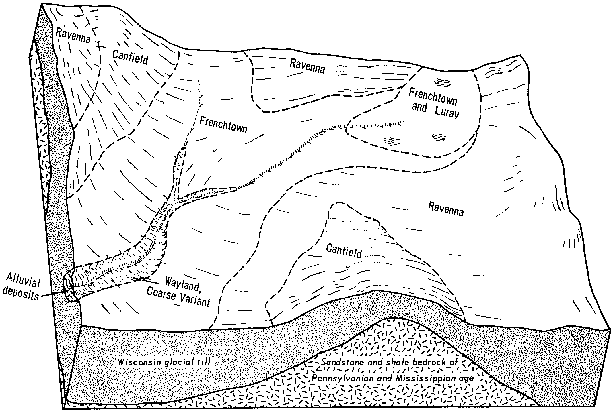
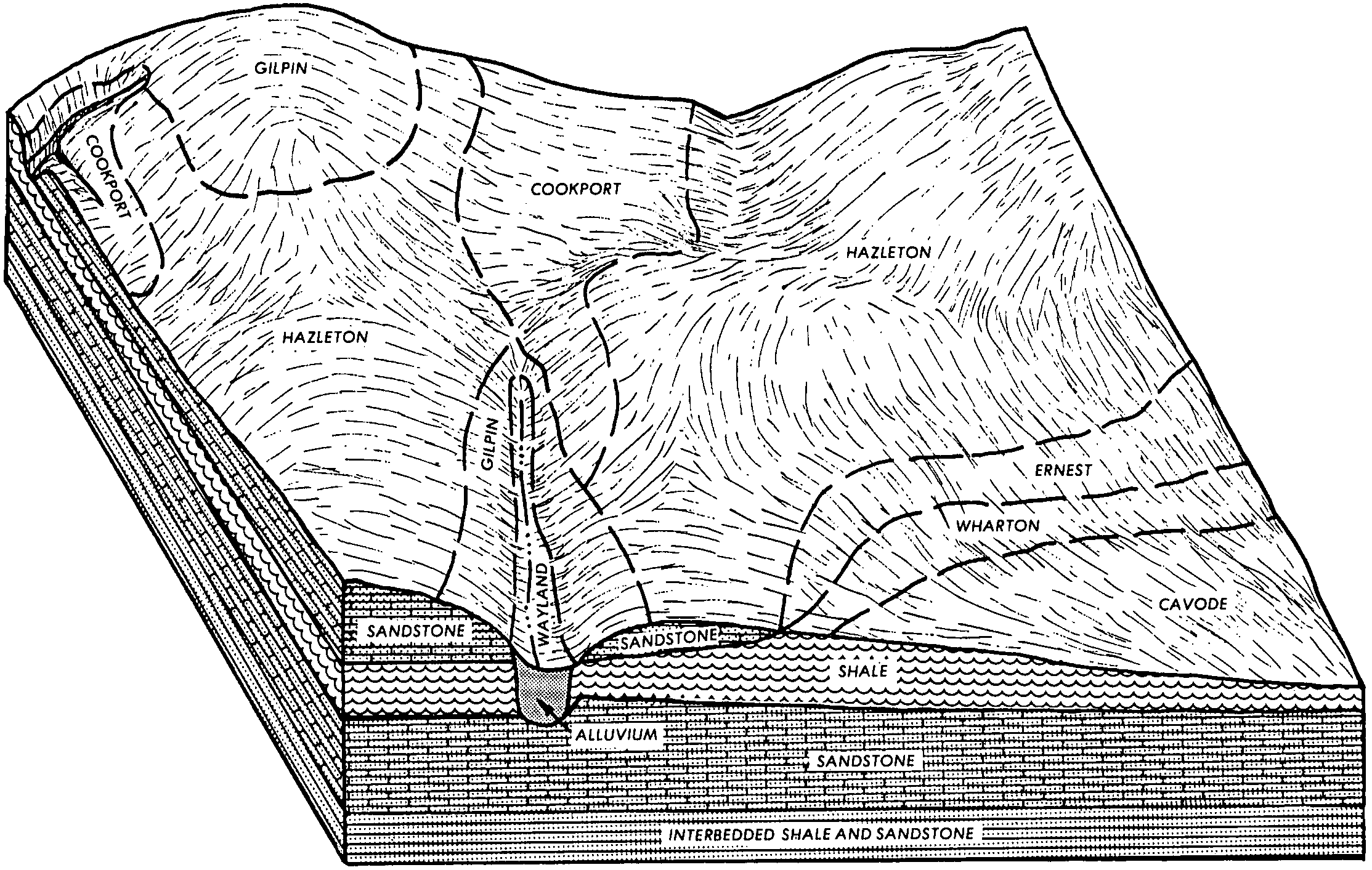
Wayland silt loam, coarse variant | Wa | 21252 | 296264 | 9y8x | pa085 | 1967 | 1:20000 |
Wayland silty clay loam | Wb | 2343 | 296369 | 9yd9 | pa089 | 1975 | 1:20000 |
Wayland and Wyalusing soils, 0 to 3 percent slopes, frequently flooded | WaA | 2041 | 2433759 | 2z5wr | pa105 | 2007 | 1:24000 |
Wayland silty clay loam | Wa | 1385 | 297172 | 9z76 | pa117 | 1973 | 1:20000 |
Wayland silt loam | Wa | 17387 | 539270 | l34t | pa609 | 1979 | 1:20000 |