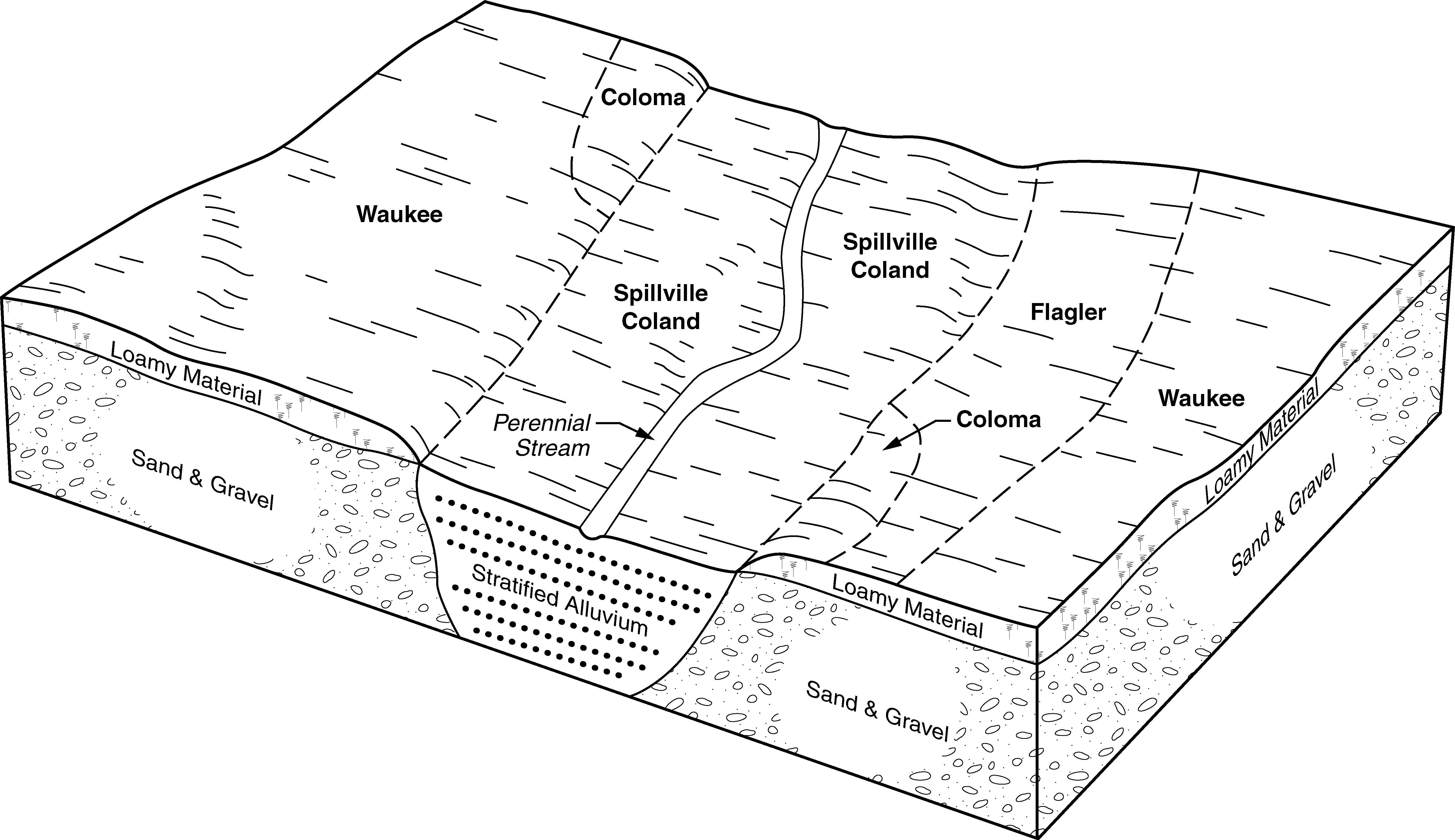
Official Series Description


Lab Data Summary

Aggregate lab data for the WAUKEE soil series. This aggregation is based on all pedons with a current taxon name of WAUKEE, and applied along 1-cm thick depth slices. Solid lines are the slice-wise median, bounded on either side by the interval defined by the slice-wise 5th and 95th percentiles. The median is the value that splits the data in half. Five percent of the data are less than the 5th percentile, and five percent of the data are greater than the 95th percentile. Values along the right hand side y-axis describe the proportion of pedon data that contribute to aggregate values at this depth. For example, a value of "90%" at 25cm means that 90% of the pedons correlated to WAUKEE were used in the calculation. Source: KSSL snapshot . Methods used to assemble the KSSL snapshot used by SoilWeb / SDE

Click the image to view it full size.

Pedons used in the lab summary:

MLRALab IDPedon IDTaxonnameCINSSL / NASIS ReportsLink To SoilWeb GMap
10440A1768S1973IA089001Waukee7Primary | Supplementary | Taxonomy | Pedon | Water Retention | Correlation | Andic Soil Properties43.2694435,-92.4580536
104X53-178-1S1982IA105005Waukee2Primary | Supplementary | Taxonomy | Pedon | Water Retention | Correlation | Andic Soil Properties42.2533907,-91.3265174
105UMN3464S1980MN1693464Waukee2Primary | Supplementary | Taxonomy | Pedon | Water Retention | Correlation | Andic Soil Properties43.9578094,-91.9844971
115A87P055087IL033005Waukee6Primary | Supplementary | Taxonomy | Pedon | Water Retention | Correlation | Andic Soil Properties39.1500015,-87.6750031
115CX23-X178-1S1972IA045020Waukee2Primary | Supplementary | Taxonomy | Pedon | Water Retention | Correlation | Andic Soil Properties41.8089723,-90.2457012
115CX23-178-2S1976IA045002Waukee2Primary | Supplementary | Taxonomy | Pedon | Water Retention | Correlation | Andic Soil Properties41.8089723,-90.2457012
91AUMN2238S1976MN0372238Waukee2Primary | Supplementary | Taxonomy | Pedon | Water Retention | Correlation | Andic Soil Properties44.6598167,-92.8841019
91AUMN2240S1976MN0372240Waukee2Primary | Supplementary | Taxonomy | Pedon | Water Retention | Correlation | Andic Soil Properties44.6666374,-92.9239273

Water Balance

Monthly water balance estimated using a leaky-bucket style model for the WAUKEE soil series. Monthly precipitation (PPT) and potential evapotranspiration (PET) have been estimated from the 50th percentile of gridded values (PRISM 1981-2010) overlapping with the extent of SSURGO map units containing each series as a major component. Monthly PET values were estimated using the method of Thornthwaite (1948). These (and other) climatic parameters are calculated with each SSURGO refresh and provided by the fetchOSD function of the soilDB package. Representative water storage values (“AWC” in the figures) were derived from SSURGO by taking the 50th percentile of profile-total water storage (sum[awc_r * horizon thickness]) for each soil series. Note that this representation of “water storage” is based on the average ability of most plants to extract soil water between 15 bar (“permanent wilting point”) and 1/3 bar (“field capacity”) matric potential. Soil moisture state can be roughly interpreted as “dry” when storage is depleted, “moist” when storage is between 0mm and AWC, and “wet” when there is a surplus. Clearly there are a lot of assumptions baked into this kind of monthly water balance. This is still a work in progress.

Click the image to view it full size.


Click the image to view it full size.

Sibling Summary

Siblings are those soil series that occur together in map units, in this case with the WAUKEE series. Sketches are arranged according to their subgroup-level taxonomic structure. Source: SSURGO snapshot , parsed OSD records and snapshot of SC database .

Click the image to view it full size.

Select annual climate data summaries for the WAUKEE series and siblings. Series are sorted according to hierarchical clustering of median values. Source: SSURGO map unit geometry and 1981-2010, 800m PRISM data .

Click the image to view it full size.

Geomorphic description summaries for the WAUKEE series and siblings. Series are sorted according to hierarchical clustering of proportions and relative hydrologic position within an idealized landform (e.g. top to bottom). Most soil series (SSURGO components) are associated with a hillslope position and one or more landform-specific positions: hills, mountain slopes, terraces, and/or flats. Proportions can be interpreted as an aggregate representation of geomorphic membership. The values printed to the left (number of component records) and right (Shannon entropy) of stacked bars can be used to judge the reliability of trends. Small Shannon entropy values suggest relatively consistent geomorphic association, while larger values suggest lack thereof. Source: SSURGO component records .

Click the image to view it full size.

Click the image to view it full size.

There are insufficient data to create the 3D mountains figure.

Click the image to view it full size.

Click the image to view it full size.

Competing Series

Soil series competing with WAUKEE share the same family level classification in Soil Taxonomy. Source: parsed OSD records and snapshot of the SC database .

Click the image to view it full size.

Select annual climate data summaries for the WAUKEE series and competing. Series are sorted according to hierarchical clustering of median values. Source: SSURGO map unit geometry and 1981-2010, 800m PRISM data .

Click the image to view it full size.

Geomorphic description summaries for the WAUKEE series and competing. Series are sorted according to hierarchical clustering of proportions and relative hydrologic position within an idealized landform (e.g. top to bottom). Proportions can be interpreted as an aggregate representation of geomorphic membership. Most soil series (SSURGO components) are associated with a hillslope position and one or more landform-specific positions: hills, mountain slopes, terraces, and/or flats. The values printed to the left (number of component records) and right (Shannon entropy) of stacked bars can be used to judge the reliability of trends. Shannon entropy values close to 0 represent soil series with relatively consistent geomorphic association, while values close to 1 suggest lack thereof. Source: SSURGO component records .

Click the image to view it full size.

Click the image to view it full size.

There are insufficient data to create the 3D mountains figure.

Click the image to view it full size.

Click the image to view it full size.

Soil series sharing subgroup-level classification with WAUKEE, arranged according to family differentiae. Hovering over a series name will print full classification and a small sketch from the OSD. Source: snapshot of SC database .

Block Diagrams

Click a link below to display the diagram. Note that these diagrams may be from multiple survey areas.

  1. IA-2010-09-09-07 | Bremer County - 2009

    Typical pattern of soils and parent material in the Spillville-Waukee-Coland association (Soil Survey of Bremer County, Iowa; 2009).

  2. IA-2011-05-31-28 | Floyd County - 1995

    Pattern of soils and parent material in the Saude-Coland-Lawler association (Soil Survey of Floyd County, Iowa; 1995).

  3. IA-2011-05-31-42 | Hardin County - 1985

    Pattern of soils and parent material in the Coland-Saude-Spillville association (Soil Survey of Hardin County, Iowa; 1985).

Map Units

Map units containing WAUKEE as a major component. Limited to 250 records.

Map Unit Name Symbol Map Unit Area (ac) Map Unit Key National Map Unit Symbol Soil Survey Area Publication Date Map Scale
Waukee loam, 2 to 5 percent slopes178B4674023792tgs8ia00519921:15840
Waukee loam, 0 to 2 percent slopes17816604028552tgs6ia01119771:15840
Waukee loam, 2 to 5 percent slopes178B13464028562tgs8ia01119771:15840
Waukee loam, 0 to 2 percent slopes17847164132342tgs6ia01320011:12000
Waukee loam, 2 to 5 percent slopes178B14854133122tgs8ia01320011:12000
Waukee-Urban land complex, 0 to 2 percent slopes4178301413311fw2mia01320011:12000
Waukee loam, 0 to 2 percent slopes, rarely flooded178777315859832tgs7ia01720081:12000
Waukee loam, 2 to 5 percent slopes, rarely flooded178B230915859842tgs9ia01720081:12000
Waukee loam, 5 to 9 percent slopes, rarely flooded178C10915861171q7h2ia01720081:12000
Waukee loam, 0 to 2 percent slopes17811364032152tgs6ia01919781:15840
Waukee loam, 0 to 2 percent slopes17856404033712tgs6ia02319781:15840
Waukee loam, 2 to 5 percent slopes178B7064033722tgs8ia02319781:15840
Waukee loam, 0 to 2 percent slopes17836774037962tgs6ia03319781:15840
Waukee loam, 2 to 5 percent slopes178B10344037972tgs8ia03319781:15840
Waukee loam, 0 to 2 percent slopes, rarely flooded1785124793012tgs7ia03719891:15840
Waukee loam, 2 to 5 percent slopes, rarely flooded178B224793002tgs9ia03719891:15840
Waukee loam, 0 to 2 percent slopes1782154042322tgs6ia04319791:15840
Waukee loam, 2 to 5 percent slopes178B9564043802tgs8ia04519781:15840
Waukee loam, 0 to 2 percent slopes1788864043792tgs6ia04519781:15840
Waukee loam, 0 to 2 percent slopes1787804050152tgs6ia05519841:15840
Waukee loam, 2 to 5 percent slopes178B1084050162tgs8ia05519841:15840
Waukee loam, 0 to 2 percent slopes17811964057292tgs6ia06519751:15840
Waukee loam, 2 to 5 percent slopes178B7824057302tgs8ia06519751:15840
Waukee loam, 0 to 2 percent slopes17841284058612tgs6ia06719891:15840
Waukee loam, 2 to 5 percent slopes178B13634058622tgs8ia06719891:15840
Waukee loam, 0 to 2 percent slopes17813414048782tgs6ia06919771:15840
Waukee loam, 2 to 5 percent slopes178B6524048792tgs8ia06919771:15840
Waukee loam, 0 to 2 percent slopes17822744062872tgs6ia07519731:15840
Waukee loam, 2 to 5 percent slopes178B6104062882tgs8ia07519731:15840
Waukee loam, 0 to 2 percent slopes1787584066312tgs6ia08319821:15840
Waukee loam, 2 to 5 percent slopes178B4124066322tgs8ia08319821:15840
Waukee loam, 0 to 2 percent slopes178A9684070322tgs6ia08919691:15840
Waukee loam, 2 to 5 percent slopes178B2754070332tgs8ia08919691:15840
Waukee loam, 2 to 5 percent slopes178B5697896662tgs8ia09520051:12000
Waukee loam, 0 to 2 percent slopes1783587896652tgs6ia09520051:12000
Waukee loam, 5 to 9 percent slopes178C200114448417dxvia09520051:12000
Waukee loam, 0 to 2 percent slopes17818644079772tgs6ia10319791:15840
Waukee loam, 0 to 2 percent slopes17811784081222tgs6ia10519881:15840
Waukee loam, 2 to 5 percent slopes178B3704081232tgs8ia10519881:15840
Waukee loam, 0 to 2 percent slopes178A40374085742tgs6ia11319701:15840
Waukee loam, 2 to 5 percent slopes178B32474085752tgs8ia11319701:15840
Waukee loam, 0 to 2 percent slopes17812764094402tgs6ia12719781:15840
Waukee silt loam, 0 to 2 percent slopes1782550409638fr84ia13119711:15840
Waukee silt loam, 2 to 5 percent slopes178B511409639fr85ia13119711:15840
Waukee variant loam, 0 to 2 percent slopes1178445411277fsz0ia16919811:15840
Waukee loam, 0 to 2 percent slopes1782874117692tgs6ia17919781:15840
Waukee loam, 0 to 2 percent slopes17851514510512tgs6ia19120051:12000
Waukee loam, 2 to 5 percent slopes178B31844510552tgs8ia19120051:12000
Spillville, occasionally flooded-Waukee complex, 0 to 2 percent slopes2486189213990941hyw2ia19120051:12000
Waukee loam, 0 to 2 percent slopes1178170825814512tgs6ia19520121:12000
Waukee loam, 0 to 2 percent slopes, rarely flooded178136723986982tgs7ia19520121:12000
Waukee loam, 2 to 5 percent slopes, rarely flooded178B37723986992tgs9ia19520121:12000
Waukee loam, 2 to 5 percent slopes1178B30025814522tgs8ia19520121:12000
Waukee loam, 0 to 2 percent slopes727A489494214710mcvil10320041:12000
Waukee loam, 2 to 5 percent slopes727B94613989621hyqtil14120051:12000
Waukee loam, 0 to 2 percent slopes727A3914789571lmz9il14120051:12000
Waukee loam, 0 to 2 percent slopes727A16031987406nszil16120021:12000
Waukee loam, 0 to 2 percent slopes727A4978793087vm8gil19520031:12000
Waukee loam, 0 to 2 percent slopes483A51944004672tgs6mn09919861:15840
Waukee loam, 2 to 5 percent slopes483B13504004682tgs8mn09919861:15840
Waukee loam, 0 to 2 percent slopes483A61474007942tgs6mn10919771:15840
Waukee loam, 2 to 5 percent slopes483B33584007952tgs8mn10919771:15840
Waukee loam, bedrock substratum, 0 to 2 percent slopes1955A1601429012gdf3mn16919871:20000
Waukee loam, bedrock substratum, 2 to 6 percent slopes1955B1198429013gdf4mn16919871:20000
Waukee loam483609429059gdgmmn16919871:20000

Map of Series Extent

Approximate geographic distribution of the WAUKEE soil series. To learn more about how this distribution was mapped, or to compare this soil series extent to others, use the Series Extent Explorer (SEE) application. Source: generalization of SSURGO geometry .