| Watchung silt loam, 0 to 3 percent slopes | WaA | 452 | 2479897 | 2p7jp | de003 | 2009 | 1:24000 |
Watchung silt loam, 3 to 8 percent slopes | WaB | 259 | 2479898 | 2p7jq | de003 | 2009 | 1:24000 |
Watchung silt loam, 0 to 8 percent slopes, very stony | WcB | 185 | 2479899 | 2p7jr | de003 | 2009 | 1:24000 |
Watchung silt loam, 3 to 8 percent slopes | WaB | 935 | 2406083 | 2lrql | md005 | 2010 | 1:12000 |
Watchung-Urban land complex, 0 to 8 percent slopes | WdB | 574 | 2483386 | 2pc57 | md005 | 2010 | 1:12000 |
Watchung silt loam, 3 to 8 percent slopes, stony | WcB | 485 | 2406088 | 2lrqr | md005 | 2010 | 1:12000 |
Watchung silt loam, 0 to 3 percent slopes | WaA | 86 | 2406080 | 2lrqh | md005 | 2010 | 1:12000 |
Conowingo-Watchung complex, 0 to 8 percent slopes, very stony | CrB | 290 | 2440775 | 2mxtp | md015 | 2009 | 1:12000 |
Watchung silt loam, 0 to 3 percent slopes | WaA | 221 | 2440773 | 2mxtm | md015 | 2009 | 1:12000 |
Watchung silt loam, 3 to 8 percent slopes | WaB | 73 | 2440774 | 2mxtn | md015 | 2009 | 1:12000 |
Watchung silt loam, 0 to 8 percent slopes | WcB | 449 | 530780 | kt9y | md021 | 2001 | 1:12000 |
Watchung silt loam, 3 to 8 percent slopes, stony | WcB | 423 | 793659 | vmvx | md027 | 2004 | 1:12000 |
Watchung silt loam, 0 to 3 percent slopes | WaA | 97 | 793658 | vmvw | md027 | 2004 | 1:12000 |
Watchung silty clay loam, 0 to 3 percent slopes | 28A | 838 | 533617 | kx8g | md031 | 1989 | 1:15840 |
Watchung very stony silt loam, 0 to 8 percent slopes | WcB | 2969 | 533459 | kx3c | md600 | 1972 | 1:15840 |
Watchung silt loam, 3 to 8 percent slopes | WaB | 2281 | 533458 | kx3b | md600 | 1972 | 1:15840 |
Watchung silt loam, 0 to 3 percent slopes | WaA | 1302 | 533457 | kx39 | md600 | 1972 | 1:15840 |
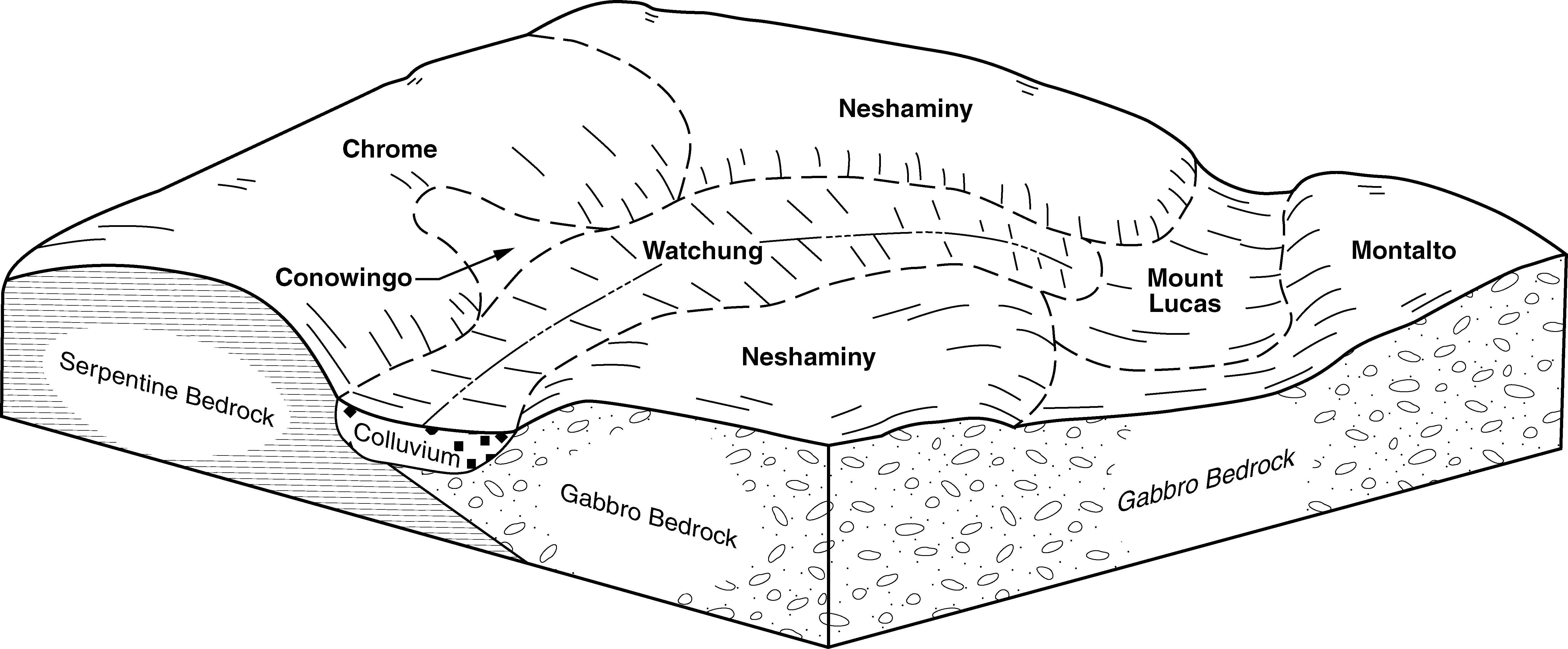
Mount Lucas-Watchung silt loams, 0 to 6 percent slopes, very stony | MopBb | 3323 | 548634 | ldww | nj019 | 1970 | 1:24000 |
Watchung silt loam, 0 to 2 percent slopes | WasA | 138 | 1427788 | 1jxqp | nj019 | 1970 | 1:24000 |
Watchung silt loam, 0 to 3 percent slopes, very rubbly | WasAe | 236 | 607168 | nct2 | nj021 | 1969 | 1:24000 |
Watchung silt loam, 0 to 2 percent slopes | WasA | 197 | 1427042 | 1jwym | nj021 | 1969 | 1:24000 |
Mount Lucas-Watchung silt loams, 0 to 6 percent slopes, very stony | MopBb | 79 | 135101 | 4jl3 | nj021 | 1969 | 1:24000 |
Mount Lucas-Watchung silt loams, 6 to 12 percent slopes, very stony | MopCb | 14 | 135102 | 4jl4 | nj021 | 1969 | 1:24000 |
Watchung silt loam, 0 to 2 percent slopes, very stony | WasAb | 788 | 1395439 | 1hv25 | nj023 | 1985 | 1:24000 |
Mount Lucas-Watchung silt loams, 6 to 12 percent slopes, very stony | MopCb | 21 | 1455179 | 1kv78 | nj023 | 1985 | 1:24000 |
Mount Lucas-Watchung silt loams, 6 to 12 percent slopes, very stony | MopCb | 6159 | 1405048 | 1j524 | nj035 | 1972 | 1:24000 |
Watchung silt loam, 0 to 2 percent slopes | WasA | 1710 | 1443931 | 1kgjf | nj035 | 1972 | 1:24000 |
Mount Lucas-Watchung silt loams, 0 to 6 percent slopes, very stony | MopBb | 105 | 1405047 | 1j523 | nj035 | 1972 | 1:24000 |
Watchung silt loam, 0 to 3 percent slopes | WaA | 5911 | 545658 | l9sw | pa001 | 1991 | 1:24000 |
Watchung silt loam, 3 to 8 percent slopes | WaB | 809 | 545659 | l9sx | pa001 | 1991 | 1:24000 |
Watchung silt loam, 0 to 8 percent slopes, extremely bouldery | WbB | 512 | 545660 | l9sy | pa001 | 1991 | 1:24000 |
Watchung silt loam, 0 to 3 percent slopes | WaA | 642 | 641642 | pjp4 | pa029 | 2008 | 1:24000 |
Watchung silt loam, 3 to 8 percent slopes | WaB | 417 | 641643 | pjp5 | pa029 | 2008 | 1:24000 |
Watchung silt loam | Wa | 627 | 540773 | l4q9 | pa043 | 1967 | 1:15840 |
Watchung very stony silt loam | Wc | 380 | 540774 | l4qb | pa043 | 1967 | 1:15840 |
Watchung silt loam, 3 to 8 percent slopes | WaB | 14 | 984456 | 2zhhw | pa045 | 2023 | 1:12000 |
Watchung silt loam, 0 to 3 percent slopes | WaA | 13 | 984455 | 2zhhv | pa045 | 2023 | 1:12000 |
Watchung silt loam, 0 to 8 percent slopes, very stony | WcB | 3 | 984530 | 30cgl | pa045 | 2023 | 1:12000 |
Watchung extremely stony silt loam, 0 to 8 percent slopes | WbB | 48 | 558454 | lr3n | pa071 | 1982 | 1:15840 |
Watchung extremely stony silt loam, 0 to 8 percent slopes | WbB | 970 | 541342 | l59n | pa075 | 1976 | 1:20000 |
Watchung silt loam, 0 to 5 percent slopes | WaA | 809 | 541341 | l59m | pa075 | 1976 | 1:20000 |
Watchung silt loam, 0 to 8 percent slopes, extremely stony | WcB | 1415 | 541261 | l571 | pa091 | 2008 | 1:12000 |
Watchung silt loam, 3 to 8 percent slopes | WaB | 534 | 541260 | l570 | pa091 | 2008 | 1:12000 |
Watchung silt loam, 0 to 3 percent slopes | WaA | 325 | 541259 | l56z | pa091 | 2008 | 1:12000 |
Watchung silt loam, 0 to 8 percent slopes, extremely bouldery | WbB | 4294 | 542963 | l6zy | pa133 | 1990 | 1:24000 |
Watchung silt loam, 0 to 3 percent slopes | WaA | 1965 | 542961 | l6zw | pa133 | 1990 | 1:24000 |
Watchung silt loam, 3 to 8 percent slopes | WaB | 267 | 542962 | l6zx | pa133 | 1990 | 1:24000 |


