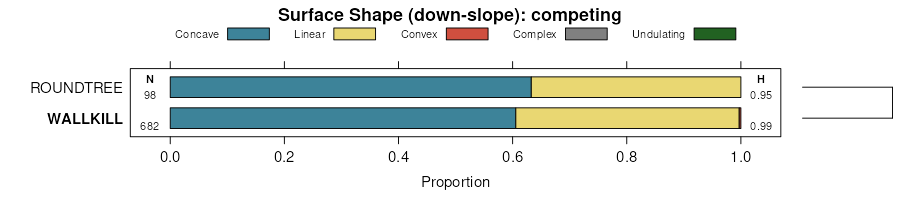
| Wallkill silty clay loam, wet | W464 | 918 | 211716 | 739k | il059 | 1966 | 1:20000 |
Wallkill silt loam, 0 to 2 percent slopes, frequently flooded | 3292A | 578 | 176963 | 5y4h | il105 | 1991 | 1:15840 |
Wallkill silty clay loam | Wc | 442 | 164756 | 5jfq | in003 | 1965 | 1:15840 |
Wallkill silt loam, 0 to 2 percent slopes | Wa | 426 | 164755 | 30kc5 | in003 | 1965 | 1:15840 |
Wallkill-Urban land complex | YubA | 14 | 3404543 | 2zy5f | in003 | 1965 | 1:15840 |
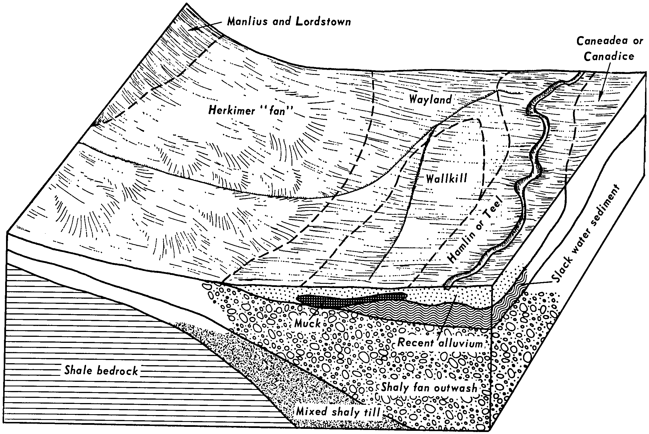
Wallkill variant silty clay loam | Wa | 681 | 164654 | 5jbf | in007 | 1985 | 1:15840 |
Wallkill silty clay, 0 to 2 percent slopes, frequently flooded | Wa | 386 | 623805 | 30kc6 | in009 | 1983 | 1:15840 |
Wallkill silt loam | Wd | 260 | 165244 | 5jyg | in015 | 1987 | 1:15840 |
Wallkill silt loam | Wa | 377 | 162364 | 5fyk | in023 | 1978 | 1:20000 |
Wallkill silt loam, 0 to 2 percent slopes | Wa | 2215 | 160348 | 30kc5 | in033 | 1980 | 1:15840 |
Wallkill silt loam, 0 to 2 percent slopes | Wa | 1262 | 162598 | 30kc5 | in049 | 1984 | 1:15840 |
Wallkill silt loam, undrained | Wa | 158 | 162816 | 5gf4 | in053 | 1985 | 1:15840 |
Wallkill silty clay, 0 to 2 percent slopes, frequently flooded | Wa | 276 | 210651 | 30kc6 | in075 | 1983 | 1:15840 |
Wallkill silt loam, undrained | Wb | 386 | 164514 | 5j5x | in083 | 1979 | 1:15840 |
Wallkill silt loam, clayey substratum, drained | Wc | 309 | 164515 | 5j5y | in083 | 1979 | 1:15840 |
Wallkill silt loam, 0 to 2 percent slopes | Wa | 771 | 160926 | 30kc5 | in085 | 1985 | 1:20000 |
Wallkill silt loam, 0 to 2 percent slopes | Wa | 248 | 272638 | 30kc5 | in087 | 1978 | 1:20000 |
Milford-Palms-Wallkill complex | Mt | 1983 | 272474 | 94jh | in089 | 1967 | 1:15840 |
Wallkill silt loam | Wa | 1549 | 272506 | 94kj | in089 | 1967 | 1:15840 |
Wallkill silt loam | Wa | 637 | 272706 | 94rz | in091 | 1979 | 1:15840 |
Wallkill complex | Wa | 116 | 162128 | 5fpy | in095 | 1965 | 1:15840 |
Wallkill silt loam | Wa | 266 | 163076 | 5gpj | in107 | 1984 | 1:15840 |
Wallkill variant mucky silty clay | Wc | 676 | 163800 | 5hfw | in111 | 1990 | 1:15840 |
Wallkill loam, pothole | Wa | 396 | 163797 | 5hfs | in111 | 1990 | 1:15840 |
Wallkill silt loam, 0 to 2 percent slopes | Wa | 1005 | 272581 | 30kc5 | in113 | 1974 | 1:15840 |
Wallkill silt loam | Wa | 679 | 160701 | 5d6x | in127 | 1978 | 1:15840 |
Wallkill silt loam, undrained | Wa | 1017 | 161320 | 5dvw | in135 | 1984 | 1:15840 |
Wallkill silt loam, 0 to 2 percent slopes | Wa | 707 | 160247 | 30kc5 | in151 | 1979 | 1:20000 |
Wallkill silt loam, coprogenous earth substratum | Wb | 544 | 164362 | 5j10 | in157 | 1990 | 1:15840 |
Wallkill silt loam, 0 to 2 percent slopes | Wc | 805 | 161238 | 30kc5 | in169 | 1980 | 1:15840 |
Wallkill variant silty clay loam | We | 316 | 163180 | 5gsw | in171 | 1987 | 1:15840 |
Wallkill silt loam, coprogenous earth substratum, drained | Wa | 141 | 161282 | 5dtn | in179 | 1988 | 1:15840 |
Wallkill silt loam, undrained | Wd | 111 | 161283 | 5dtp | in179 | 1988 | 1:15840 |
Wallkill silty clay loam | Wa | 2204 | 161829 | 5fd9 | in183 | 1985 | 1:15840 |
Wallkill loam | Wa | 245 | 186407 | 67z4 | mi037 | 1974 | 1:15840 |
Wallkill silt loam | Wa | 302 | 186907 | 68h8 | mi049 | 1967 | 1:20000 |
Wallkill silt loam | 46 | 32 | 188660 | 6b9t | mi059 | 1991 | 1:15840 |
Wallkill soils | Wa | 69 | 188213 | 69vd | mi067 | 1965 | 1:15840 |
Wallkill silt loam | 31 | 589 | 187132 | 68qj | mi081 | 1984 | 1:15840 |
Kokomo, Barry, and Wallkill loams, overwashed, 0 to 3 percent slopes | KgA | 3502 | 188506 | 6b4v | mi091 | 1957 | 1:20000 |
Wallkill loam, overwashed, 0 to 3 percent slopes | WaA | 530 | 188576 | 6b73 | mi091 | 1957 | 1:20000 |
Wallkill silt loam | Wa | 790 | 192746 | 6gkm | mi139 | 1967 | 1:15840 |
Wallkill loam, 0 to 2 percent slopes | WaA0 | 539 | 188418 | 6b20 | mi151 | 1955 | 1:15840 |
Wallkill loam | Wa | 61 | 187858 | 69gy | mi155 | 1967 | 1:12000 |
Wallkill loam, 0 to 2 percent slopes | 116A | 3 | 2508114 | 6b20 | mi157 | 1984 | 1:15840 |
Wallkill mucky silt loam, 0 to 3 percent slopes, frequently flooded | WaakAt | 183 | 813402 | w9ds | nj013 | 2003 | 1:12000 |
Wallkill silt loam, 0 to 3 percent slopes, frequently flooded | WaahAt | 1164 | 808435 | w47k | nj037 | 2002 | 1:24000 |
Wallkill silt loam, 0 to 2 percent slopes | WaA | 618 | 2677805 | bmp8 | ny049 | 2018 | 1:24000 |
Wallkill silt loam, 0 to 2 percent slopes, frequently flooded | 7A | 1590 | 3105638 | 2y9v0 | ny051 | 2019 | 1:24000 |
Wallkill silt loam | Wa | 729 | 292643 | 9tj3 | ny053 | 1975 | 1:15840 |
Wallkill silt loam | 982 | 404 | 293509 | 9vf1 | ny065 | 1993 | 1:24000 |
Wallkill silt loam | Wa | 2045 | 293989 | 9vxj | ny071 | 1976 | 1:15840 |
Wallkill silt loam | Wa | 162 | 294159 | 9w30 | ny075 | 1973 | 1:15840 |
Wallkill mucky peat, 0 to 3 percent slopes, frequently ponded | WkA | 22 | 2507093 | 2q6hf | ny085 | 2014 | 1:12000 |
Wallkill silt loam | Wk | 346 | 294670 | 9wmh | ny097 | 1976 | 1:15840 |
Wallkill soils | Wk | 553 | 294780 | 9wr1 | ny099 | 1966 | 1:15840 |
Wallkill silt loam | Wk | 1417 | 295438 | 9xf8 | ny121 | 1969 | 1:20000 |
Wallkill silt loam | Wb | 289 | 288206 | 9nwz | oh005 | 1976 | 1:15840 |
Wallkill silty clay loam | Wa | 3 | 1146253 | 17grx | oh011 | 1979 | 1:15840 |
Wallkill silt loam | Wa | 1001 | 171486 | 5rft | oh021 | 1966 | 1:15840 |
Wallkill silt loam, occasionally flooded | Wb | 55 | 1413805 | 1jg5m | oh021 | 1966 | 1:15840 |
Wallkill silt loam, occasionally flooded | Wc | 258 | 171787 | 5rrj | oh023 | 1997 | 1:15840 |
Wallkill silt loam | Wb | 126 | 168602 | 5nfs | oh033 | 1975 | 1:15840 |
Wallkill silt loam, lacustrine substratum, occasionally flooded | Wc | 36 | 709034 | rst2 | oh033 | 1975 | 1:15840 |
Wallkill silt loam | Wb | 697 | 168532 | 5ncj | oh037 | 1984 | 1:15840 |
Wallkill silt loam, ponded | Wc | 252 | 287600 | 9n8f | oh055 | 1979 | 1:15840 |
Wallkill silt loam, frequently flooded | Wa | 247 | 168970 | 5ntn | oh065 | 1987 | 1:15840 |
Wallkill silt loam | Wb | 2 | 1611231 | 1r2m6 | oh065 | 1987 | 1:15840 |
Wallkill silt loam | Wa | 9 | 1676999 | 1t91r | oh075 | 1989 | 1:15840 |
Wallkill silt loam, lacustrine substratum, occasionally flooded | Wa | 184 | 168007 | 5mtl | oh077 | 1988 | 1:15840 |
Wallkill silt loam, clayey substratum, frequently flooded | Wa | 355 | 171089 | 5r10 | oh089 | 1986 | 1:15840 |
Wallkill silt loam | Wa | 1447 | 171173 | 5r3q | oh091 | 1977 | 1:15840 |
Wallkill silty clay loam | Wb | 5 | 1593186 | 1qgv3 | oh091 | 1977 | 1:15840 |
Wallkill silt loam | Wa | 2 | 1402808 | 1j2qw | oh097 | 1978 | 1:15840 |
Wallkill silt loam | Wc | 347 | 288395 | 9p32 | oh103 | 1974 | 1:15840 |
Wallkill silt loam | Wa | 71 | 169544 | 5pf5 | oh109 | 1973 | 1:15840 |
Wallkill silt loam | Wc | 241 | 288505 | 9p6m | oh133 | 1973 | 1:15840 |
Wallkill silt loam | Wc | 69 | 170815 | 5qr5 | oh139 | 1971 | 1:15840 |
Wallkill silty clay loam | Wb | 310 | 170068 | 5pz2 | oh149 | 1977 | 1:15840 |
Wallkill silt loam, clayey subsoil variant | Wc | 477 | 288097 | 9nsg | oh151 | 1967 | 1:15840 |
Wallkill silt loam | Wg | 4 | 1595548 | 1qk99 | oh151 | 1967 | 1:15840 |
Wallkill silt loam | Wc | 241 | 825412 | wpx6 | oh153 | 1969 | 1:20000 |
Wallkill silt loam | Wc | 503 | 287239 | 9mws | oh169 | 1981 | 1:15840 |
Wallkill silt loam, 0 to 2 percent slopes | Wc | 561 | 168211 | 30kc5 | oh171 | 1975 | 1:15840 |
Wallkill silt loam | Wa | 986 | 281862 | 9g9b | vt011 | 1976 | 1:20000 |
Wallkill silt loam, 0 to 2 percent slopes, frequently flooded | 649A | 1219 | 2512321 | 2psw4 | wi011 | 1960 | 1:12000 |
Wallkill silt loam | 7649A | 540 | 423379 | g6kd | wi021 | 1972 | 1:15840 |
Wallkill silt loam | 7649A | 113 | 425585 | g8vk | wi039 | 1967 | 1:15840 |
Wallkill silt loam, frequently flooded | 649A | 372 | 425386 | g8n4 | wi045 | 1969 | 1:12000 |
Wallkill silt loam | 649A | 79 | 424734 | g7z3 | wi049 | 1960 | 1:20000 |
Wallkill silt loam | 7649A | 83 | 3268724 | g7b7 | wi059 | 2023 | 1:15840 |
Wallkill silt loam | 7649A | 83 | 3403374 | g96t | wi079 | 2023 | 1:15840 |
Wallkill silt loam | 7649A | 258 | 3268801 | g7b7 | wi101 | 2023 | 1:15840 |
Wallkill silt loam, 0 to 2 percent slopes, frequently flooded | 649A | 2244 | 2639502 | 2psw4 | wi121 | 1969 | 1:12000 |
Wallkill silt loam | 7649A | 302 | 425684 | g8yr | wi127 | 1967 | 1:15840 |
Wallkill silt loam | 7649A | 782 | 425791 | g926 | wi131 | 1967 | 1:15840 |
Wallkill silt loam | 7649A | 651 | 3403485 | g96t | wi133 | 2023 | 1:15840 |


