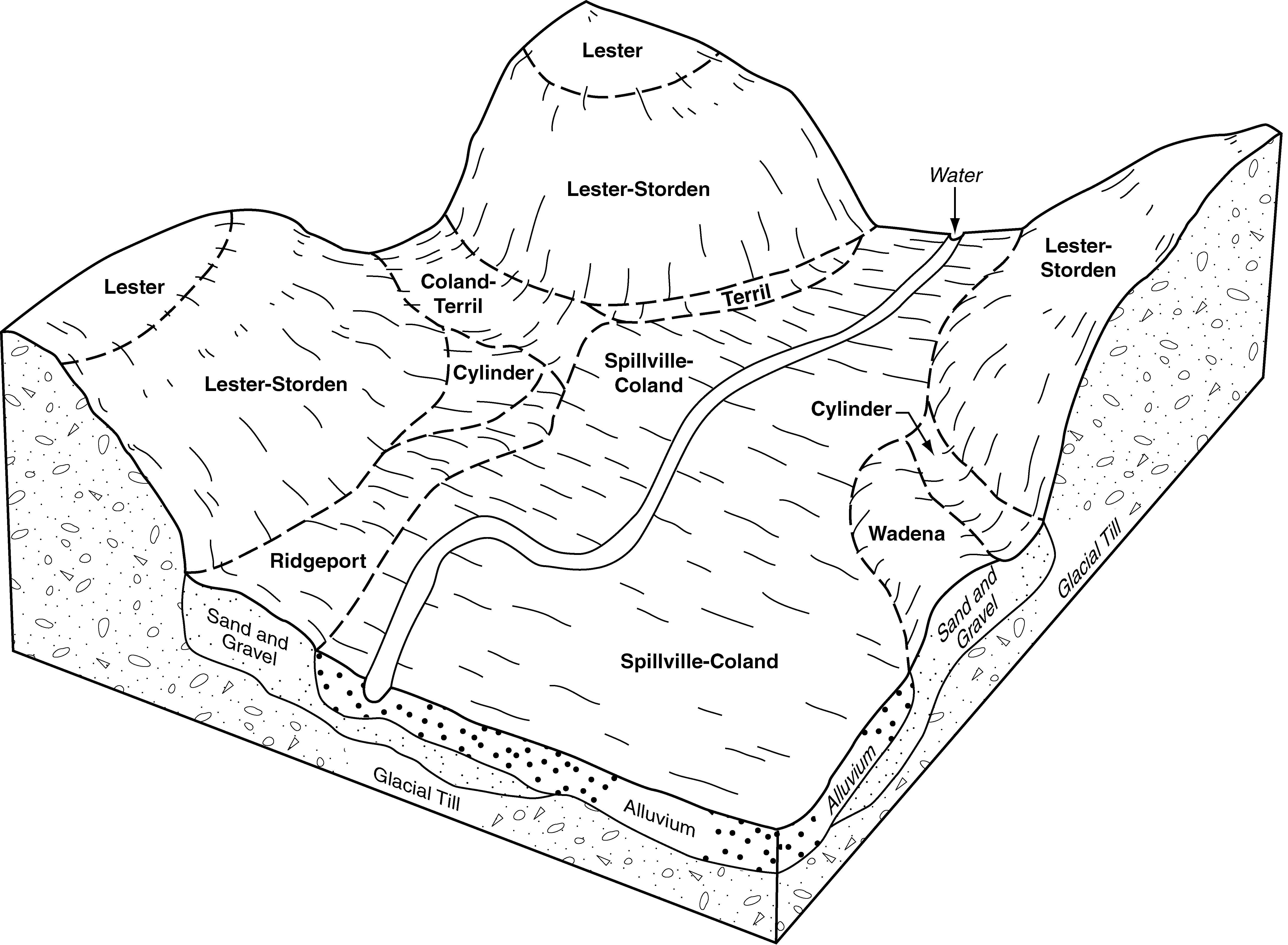
| Wadena loam, 2 to 6 percent slopes | 308B | 666 | 2550258 | 2wd86 | ia015 | 1977 | 1:15840 |
Wadena loam, 0 to 2 percent slopes | 308 | 425 | 2550257 | 2wd85 | ia015 | 1977 | 1:15840 |
Wadena loam, 2 to 6 percent slopes | 108B | 5171 | 403273 | 2wd86 | ia021 | 1973 | 1:15840 |
Wadena loam, 0 to 2 percent slopes | 108 | 1248 | 403272 | 2wd85 | ia021 | 1973 | 1:15840 |
Wadena loam, 6 to 12 percent slopes, moderately eroded | 108C2 | 877 | 403274 | 2wd88 | ia021 | 1973 | 1:15840 |
Wadena loam, 2 to 6 percent slopes | 108B | 3189 | 403455 | 2wd86 | ia025 | 1979 | 1:15840 |
Wadena loam, 0 to 2 percent slopes | 108 | 1953 | 403454 | 2wd85 | ia025 | 1979 | 1:15840 |
Wadena loam, 6 to 12 percent slopes, moderately eroded | 108C2 | 306 | 403456 | 2wd88 | ia025 | 1979 | 1:15840 |
Wadena loam, 0 to 2 percent slopes | 108 | 2855 | 403501 | 2wd85 | ia027 | 1979 | 1:15840 |
Wadena loam, 2 to 6 percent slopes | 108B | 2117 | 403502 | 2wd86 | ia027 | 1979 | 1:15840 |
Wadena loam, 6 to 12 percent slopes, moderately eroded | 108C2 | 423 | 403503 | 2wd88 | ia027 | 1979 | 1:15840 |
Wadena loam, 24 to 32 inches to sand and gravel, 0 to 2 percent | 108 | 1392 | 403900 | fk91 | ia035 | 1987 | 1:15840 |
Wadena loam, 24 to 32 inches to sand and gravel, 2 to 5 percent | 108B | 637 | 403901 | fk92 | ia035 | 1987 | 1:15840 |
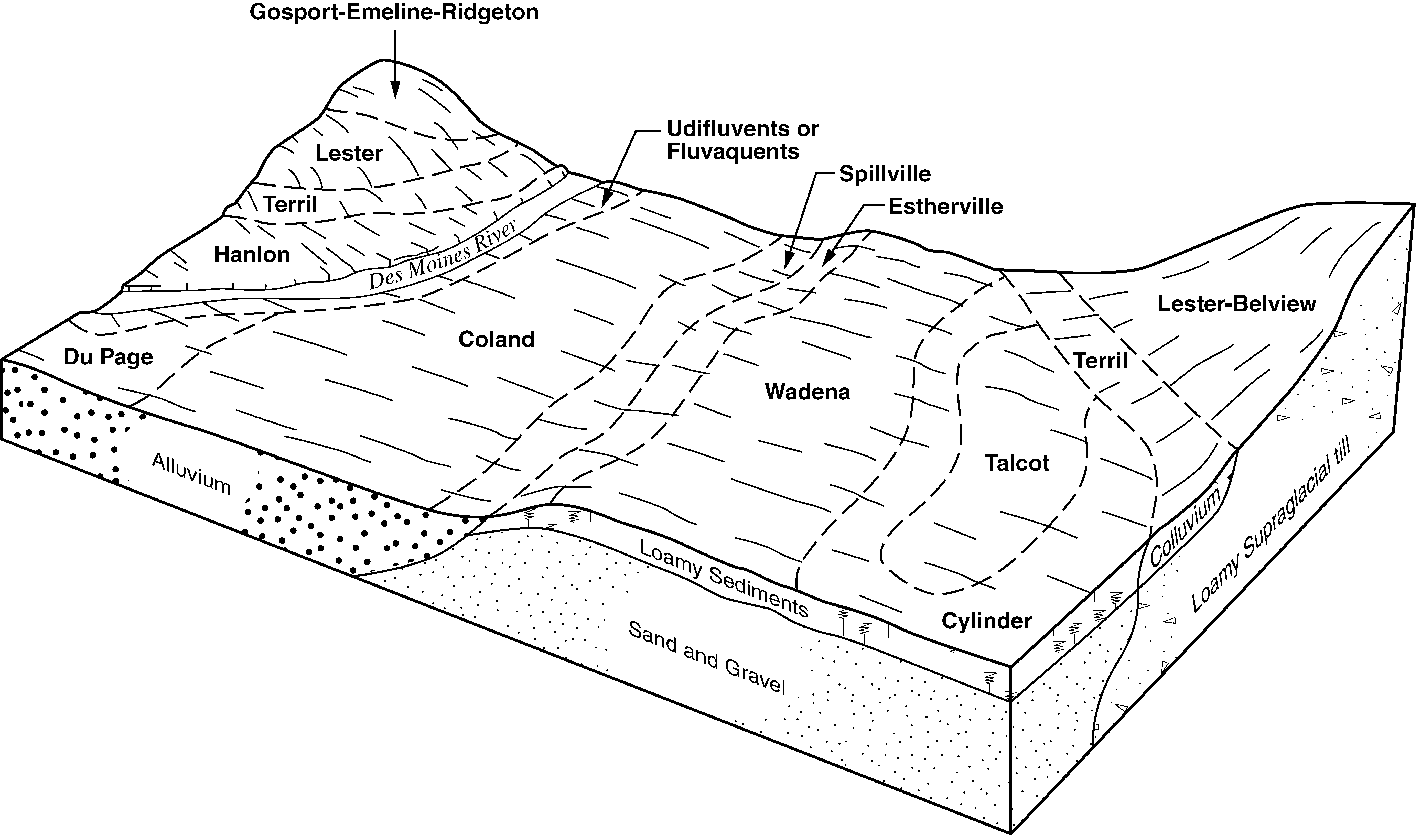
Wadena loam, 0 to 2 percent slopes | 108 | 17090 | 399274 | 2wd85 | ia041 | 2002 | 1:12000 |
Wadena loam, 2 to 6 percent slopes | 108B | 5670 | 399275 | 2wd86 | ia041 | 2002 | 1:12000 |
Wadena loam, 0 to 2 percent slopes | 308 | 1546 | 404590 | 2wd85 | ia049 | 1980 | 1:15840 |
Wadena loam, 2 to 6 percent slopes | 308B | 939 | 404591 | 2wd86 | ia049 | 1980 | 1:15840 |
Wadena loam, 0 to 2 percent slopes | 308 | 4395 | 1869039 | 2wd85 | ia059 | 2011 | 1:12000 |
Wadena loam, 2 to 6 percent slopes | 308B | 2227 | 1869040 | 2wd86 | ia059 | 2011 | 1:12000 |
Wadena-Augusta Lake-Clarion complex, 2 to 5 percent slopes | 327B | 542 | 2481365 | 2p921 | ia059 | 2011 | 1:12000 |
Wadena loam, 6 to 12 percent slopes | 308C | 111 | 1869041 | 2wd87 | ia059 | 2011 | 1:12000 |
Wadena-Augusta Lake-Clarion complex, 0 to 2 percent slopes | 327 | 58 | 2481364 | 2p920 | ia059 | 2011 | 1:12000 |
Wadena loam, 0 to 2 percent slopes | 108 | 906 | 405495 | 2wd85 | ia063 | 1989 | 1:15840 |
Wadena loam, 0 to 2 percent slopes | 108 | 2810 | 406184 | 2wd85 | ia073 | 1983 | 1:15840 |
Wadena loam, 2 to 6 percent slopes | 108B | 2297 | 406185 | 2wd86 | ia073 | 1983 | 1:15840 |
Wadena variant loam, 0 to 2 percent slopes | 1308 | 462 | 406188 | fmnv | ia073 | 1983 | 1:15840 |
Wadena loam, 6 to 12 percent slopes, moderately eroded | 108C2 | 404 | 406186 | 2wd88 | ia073 | 1983 | 1:15840 |
Wadena loam, 2 to 6 percent slopes | 108B | 1584 | 406334 | 2wd86 | ia077 | 1968 | 1:15840 |
Wadena loam, 0 to 2 percent slopes | 108A | 523 | 406333 | 2wd85 | ia077 | 1968 | 1:15840 |
Wadena loam, 6 to 12 percent slopes, moderately eroded | 108C2 | 277 | 406335 | 2wd88 | ia077 | 1968 | 1:15840 |
Wadena loam, 6 to 12 percent slopes | 308C | 236 | 406375 | 2wd87 | ia077 | 1968 | 1:15840 |
Wadena loam, 2 to 6 percent slopes | 108B | 1283 | 406451 | 2wd86 | ia079 | 1984 | 1:15840 |
Wadena loam, 0 to 2 percent slopes | 308 | 1054 | 406478 | 2wd85 | ia079 | 1984 | 1:15840 |
Wadena loam, 0 to 2 percent slopes | 308 | 2505 | 406546 | 2wd85 | ia081 | 1987 | 1:15840 |
Wadena loam, 2 to 6 percent slopes | 308B | 968 | 406547 | 2wd86 | ia081 | 1987 | 1:15840 |
Wadena loam, 0 to 2 percent slopes | 308 | 1201 | 447538 | 2wd85 | ia091 | 1998 | 1:12000 |
Wadena loam, 2 to 6 percent slopes | 308B | 607 | 447539 | 2wd86 | ia091 | 1998 | 1:12000 |
Wadena loam, 2 to 6 percent slopes | 108B | 1103 | 408336 | 2wd86 | ia109 | 1980 | 1:15840 |
Wadena loam, 0 to 2 percent slopes | 108 | 807 | 408335 | 2wd85 | ia109 | 1980 | 1:15840 |
Wadena loam, 0 to 2 percent slopes | 108 | 3491 | 410107 | 2wd85 | ia143 | 1985 | 1:15840 |
Wadena loam, 2 to 6 percent slopes | 108B | 1421 | 410108 | 2wd86 | ia143 | 1985 | 1:15840 |
Wadena loam, 24 to 32 inches to sand and gravel, 2 to 5 percent slopes, moderately eroded | 108B2 | 46 | 410109 | frrb | ia143 | 1985 | 1:15840 |
Wadena-Augusta Lake-Clarion complex, 0 to 2 percent slopes | 327 | 35 | 2506568 | 2q4mf | ia143 | 1985 | 1:15840 |
Wadena-Augusta Lake-Clarion complex, 2 to 5 percent slopes | 327B | 31 | 2506569 | 2q4mg | ia143 | 1985 | 1:15840 |
Wadena loam, 0 to 2 percent slopes | 308 | 518 | 410270 | 2wd85 | ia147 | 1973 | 1:15840 |
Galva-Wadena complex, 5 to 14 percent slopes, moderately eroded | 317C2 | 1091 | 410343 | frzw | ia149 | 1972 | 1:20000 |
Ida-Wadena complex, 5 to 14 percent slopes, severely eroded | 114D3 | 466 | 410316 | frz0 | ia149 | 1972 | 1:20000 |
Wadena loam, 2 to 5 percent slopes | 108B | 263 | 410311 | fryv | ia149 | 1972 | 1:20000 |
Wadena loam, 2 to 6 percent slopes | 108B | 3307 | 410368 | 2wd86 | ia151 | 1982 | 1:15840 |
Wadena loam, 0 to 2 percent slopes | 108 | 444 | 410367 | 2wd85 | ia151 | 1982 | 1:15840 |
Wadena loam, 6 to 12 percent slopes | 108C2 | 344 | 410369 | 2wd87 | ia151 | 1982 | 1:15840 |
Wadena loam, 0 to 2 percent slopes | 108 | 1041 | 412819 | 2wd85 | ia153 | 1993 | 1:12000 |
Wadena-Urban land complex, 0 to 2 percent slopes | 4308 | 967 | 412934 | fvpg | ia153 | 1993 | 1:12000 |
Wadena loam, 2 to 6 percent slopes | 108B | 436 | 412820 | 2wd86 | ia153 | 1993 | 1:12000 |
Wadena loam, 2 to 6 percent slopes | 108B | 2764 | 410756 | 2wd86 | ia161 | 1975 | 1:15840 |
Wadena loam, 0 to 2 percent slopes | 108 | 2751 | 410755 | 2wd85 | ia161 | 1975 | 1:15840 |
Wadena loam, 6 to 12 percent slopes | 108C2 | 254 | 410757 | 2wd87 | ia161 | 1975 | 1:15840 |
Wadena loam, 32 to 40 inches to sand and gravel, 0 to 2 percent | 308 | 4292 | 411207 | fswr | ia167 | 1987 | 1:15840 |
Wadena loam, 24 to 32 inches to sand and gravel, 0 to 2 percent | 108 | 2443 | 411192 | fsw8 | ia167 | 1987 | 1:15840 |
Wadena loam, 24 to 32 inches to sand and gravel, 2 to 5 percent | 108B | 661 | 411193 | fsw9 | ia167 | 1987 | 1:15840 |
Wadena loam, 32 to 40 inches to sand and gravel, 2 to 5 percent | 308B | 429 | 411208 | fsws | ia167 | 1987 | 1:15840 |
Wadena loam, 0 to 2 percent slopes | 108 | 905 | 411275 | 2wd85 | ia169 | 1981 | 1:15840 |
Wadena loam, 2 to 6 percent slopes | 108B | 524 | 411276 | 2wd86 | ia169 | 1981 | 1:15840 |
Wadena loam, 0 to 2 percent slopes | 108 | 2041 | 798139 | 2wd85 | ia187 | 2006 | 1:12000 |
Wadena loam, 2 to 6 percent slopes | 108B | 1366 | 798142 | 2wd86 | ia187 | 2006 | 1:12000 |
Wadena loam, loamy substratum, 2 to 5 percent slopes | 227B | 760 | 1707306 | 1v9ld | ia187 | 2006 | 1:12000 |
Wadena loam, loamy substratum, 0 to 2 percent slopes | 227 | 485 | 1613672 | 1r54y | ia187 | 2006 | 1:12000 |
Wadena loam, 6 to 12 percent slopes | 108C | 121 | 798143 | 2wd87 | ia187 | 2006 | 1:12000 |
Wadena loam, 0 to 2 percent slopes | 108 | 5478 | 412650 | 2wd85 | ia197 | 1988 | 1:15840 |
Wadena loam, 2 to 6 percent slopes | 108B | 4596 | 412651 | 2wd86 | ia197 | 1988 | 1:15840 |
Wadena loam, 6 to 12 percent slopes, moderately eroded | 108C2 | 617 | 412652 | 2wd88 | ia197 | 1988 | 1:15840 |
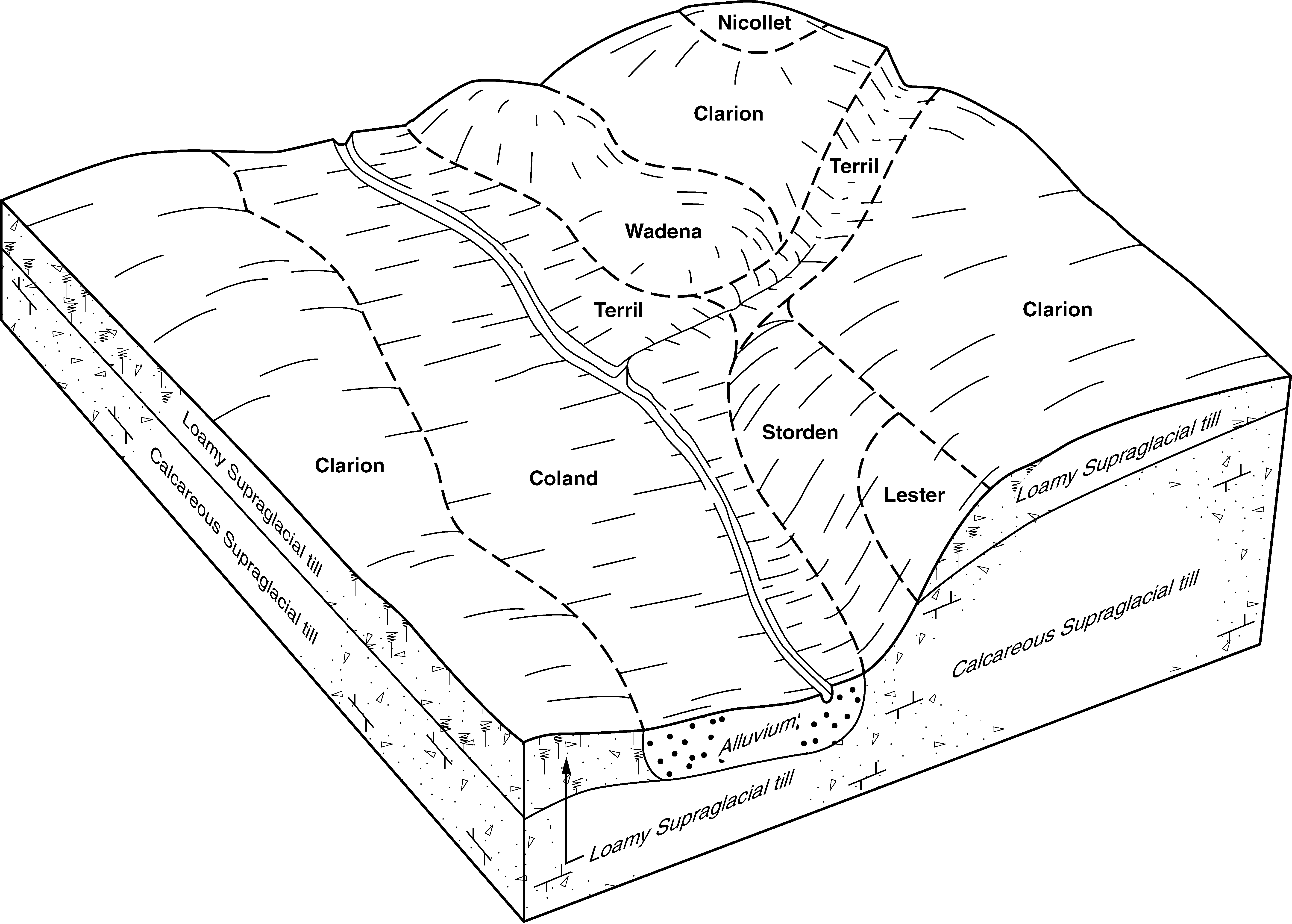
Wadena loam, 0 to 2 percent slopes | 39 | 1057 | 396185 | 2wd85 | mn013 | 1975 | 1:12000 |
Wadena loam, 2 to 6 percent slopes | 39B | 852 | 396186 | 2wd86 | mn013 | 1975 | 1:12000 |
Wadena loam, 0 to 2 percent slopes | WA | 1142 | 396473 | 2wd85 | mn019 | 1987 | 1:12000 |
Wadena loam, 2 to 6 percent slopes | WB | 686 | 396475 | 2wd86 | mn019 | 1987 | 1:12000 |
Wadena loam, 6 to 12 percent slopes, moderately eroded | WC2 | 164 | 396476 | 2wd88 | mn019 | 1987 | 1:12000 |
Wadena loam, 2 to 6 percent slopes | 39B | 16148 | 396847 | 2wd86 | mn037 | 1980 | 1:15840 |
Wadena loam, 0 to 2 percent slopes | 39A | 15078 | 396846 | 2wd85 | mn037 | 1980 | 1:15840 |
Wadena loam, 2 to 6 percent slopes, eroded | 39B2 | 2754 | 396848 | f9yk | mn037 | 1980 | 1:15840 |
Wadena loam, 6 to 12 percent slopes | 39C | 1049 | 396849 | 2wd87 | mn037 | 1980 | 1:15840 |
Wadena loam, 6 to 12 percent slopes, moderately eroded | 39C2 | 511 | 396850 | 2wd88 | mn037 | 1980 | 1:15840 |
Wadena-Hawick complex, 2 to 6 percent slopes | 889B | 342 | 396899 | fb06 | mn037 | 1980 | 1:15840 |
Wadena-Hawick complex, 6 to 12 percent slopes | 889C | 322 | 396900 | fb07 | mn037 | 1980 | 1:15840 |
Wadena loam, 12 to 18 percent slopes | 39D | 258 | 396851 | f9yn | mn037 | 1980 | 1:15840 |
Wadena-Hawick complex, 12 to 18 percent slopes | 889D | 167 | 396901 | fb08 | mn037 | 1980 | 1:15840 |
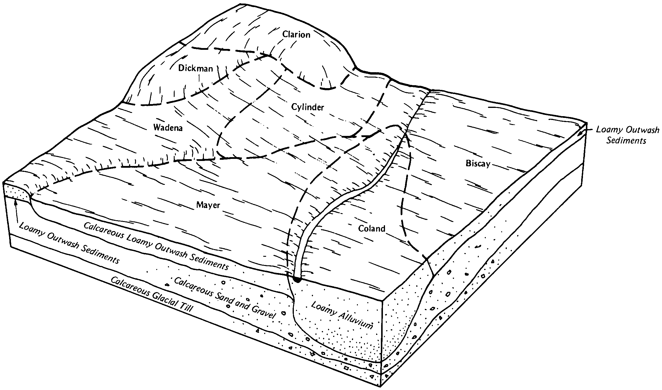
Wadena loam, 2 to 6 percent slopes | 39B | 1970 | 398512 | 2wd86 | mn063 | 1984 | 1:20000 |
Wadena loam, 0 to 2 percent slopes | 39A | 663 | 398511 | 2wd85 | mn063 | 1984 | 1:20000 |
Wadena loam, 2 to 6 percent slopes | 39B | 978 | 398958 | 2wd86 | mn079 | 1986 | 1:20000 |
Wadena loam, 0 to 2 percent slopes | 39A | 328 | 398957 | 2wd85 | mn079 | 1986 | 1:20000 |
Wadena loam, 0 to 2 percent slopes | L139A | 87 | 1544673 | 2wd85 | mn081 | 2007 | 1:12000 |
Wadena loam, 2 to 6 percent slopes | L139B | 25 | 1544674 | 2wd86 | mn081 | 2007 | 1:12000 |
Wadena loam, 0 to 2 percent slopes | L139A | 19 | 2399814 | 2wd85 | mn083 | 2008 | 1:12000 |
Wadena loam, 2 to 6 percent slopes | 39B | 342 | 399170 | 2wd86 | mn085 | 1993 | 1:20000 |
Wadena loam, 0 to 2 percent slopes | 39A | 318 | 399169 | 2wd85 | mn085 | 1993 | 1:20000 |
Wadena loam, 2 to 6 percent slopes | 39B | 233 | 400051 | 2wd86 | mn091 | 1985 | 1:20000 |
Wadena loam, 0 to 2 percent slopes | 39A | 1188 | 436366 | 2wd85 | mn093 | 1996 | 1:20000 |
Wadena loam, 2 to 6 percent slopes | L139B | 8 | 2399036 | 2wd86 | mn101 | 2008 | 1:12000 |
Wadena loam, 0 to 2 percent slopes | 39A | 453 | 400599 | 2wd85 | mn103 | 1990 | 1:20000 |
Wadena loam, 2 to 6 percent slopes | 39B | 452 | 400600 | 2wd86 | mn103 | 1990 | 1:20000 |
Wadena loam, 2 to 6 percent slopes | L139B | 420 | 785114 | 2wd86 | mn105 | 2004 | 1:12000 |
Wadena loam, 0 to 2 percent slopes | L139A | 373 | 784820 | 2wd85 | mn105 | 2004 | 1:12000 |
Wadena loam, 0 to 2 percent slopes | 39A | 1759 | 2374007 | 2wd85 | mn127 | 2008 | 1:12000 |
Wadena loam, 2 to 6 percent slopes | 39B | 1027 | 2374008 | 2wd86 | mn127 | 2008 | 1:12000 |
Wadena variant loam, 2 to 6 percent slopes | 1853B | 882 | 2374067 | 2kpdt | mn127 | 2008 | 1:12000 |
Wadena variant loam, 0 to 2 percent slopes | 1853A | 685 | 2374066 | 2kpds | mn127 | 2008 | 1:12000 |
Wadena loam, 0 to 2 percent slopes | 39A | 862 | 436094 | 2wd85 | mn129 | 1995 | 1:20000 |
Wadena loam, 2 to 6 percent slopes | 39B | 453 | 436095 | 2wd86 | mn129 | 1995 | 1:20000 |
Wadena loam, 0 to 2 percent slopes | 39A | 1054 | 429656 | 2wd85 | mn131 | 1996 | 1:12000 |
Wadena loam, 0 to 2 percent slopes | LaA | 258 | 428007 | 2wd85 | mn139 | 1988 | 1:20000 |
Wadena loam, 2 to 6 percent slopes | WaB | 1490 | 428301 | 2wd86 | mn147 | 1967 | 1:20000 |
Wadena loam, 0 to 2 percent slopes | WaA | 1318 | 428300 | 2wd85 | mn147 | 1967 | 1:20000 |
Wadena loam, 6 to 12 percent slopes, moderately eroded | WaC2 | 155 | 428302 | 2wd88 | mn147 | 1967 | 1:20000 |


