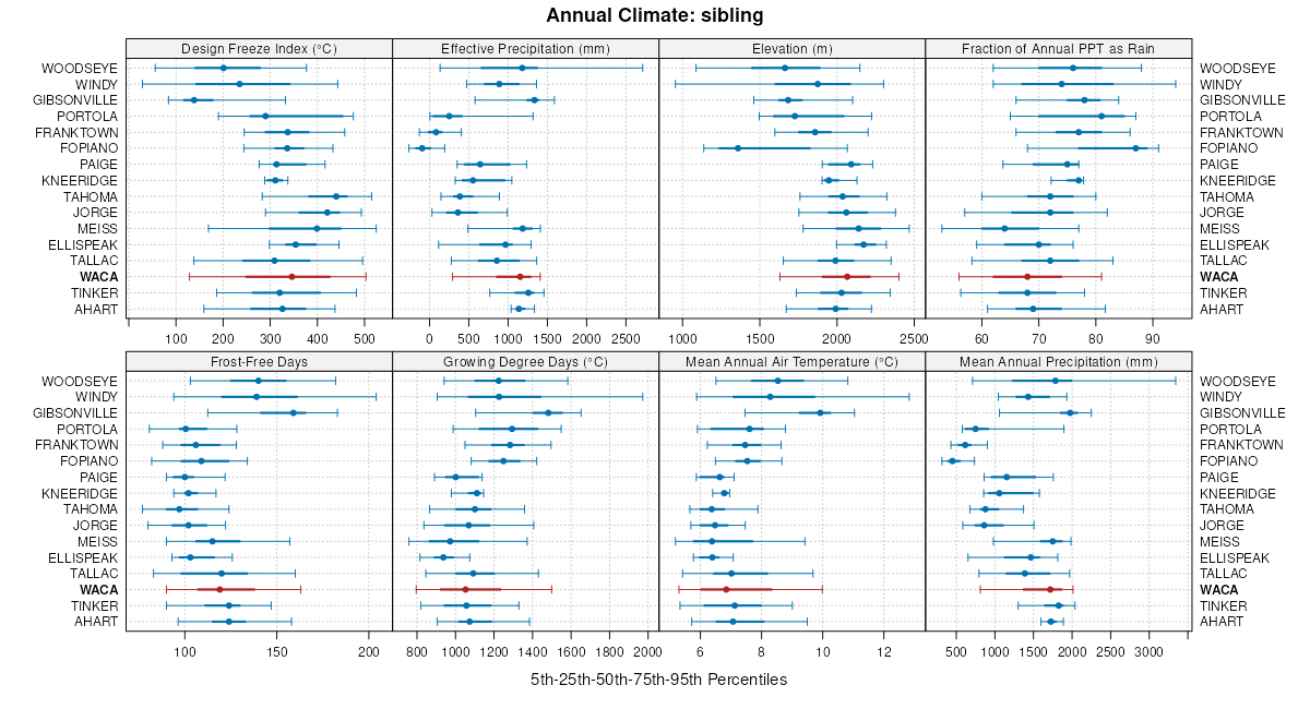
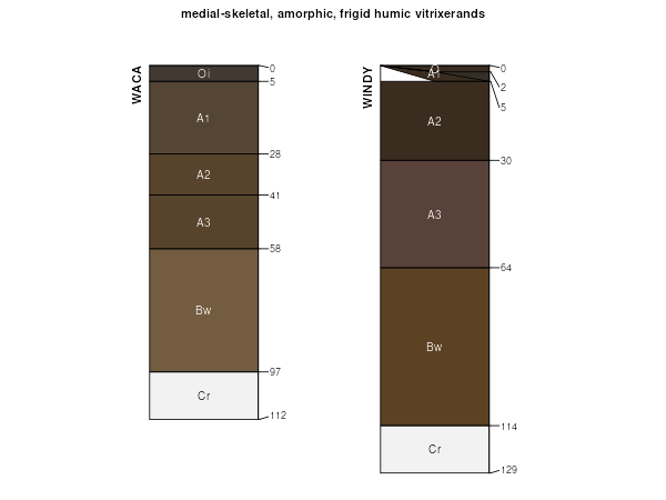
| Waca-Windy complex, 2 to 30 percent slopes *** | WAE | 37 | 3233127 | 2zms1 | ca614 | 1967 | 1:24000 |
Waca-Humicryepts, wet-Windy complex, 30 to 50 percent slopes | WBF | 11 | 3233129 | 2zms2 | ca614 | 1967 | 1:24000 |
Waca very gravelly medial coarse sandy loam, 9 to 30 percent slopes | 7231 | 2365 | 1652212 | 1sg85 | ca693 | 2006 | 1:24000 |
Waca very gravelly medial coarse sandy loam, 30 to 50 percent slopes | 7232 | 1807 | 1652213 | 1sg86 | ca693 | 2006 | 1:24000 |
Ellispeak-Waca complex, 9 to 30 percent slopes | 7131 | 966 | 1652099 | 1sg4j | ca693 | 2006 | 1:24000 |
Ellispeak-Waca complex, 30 to 50 percent slopes | 7132 | 441 | 1652100 | 1sg4k | ca693 | 2006 | 1:24000 |
Waca very gravelly medial coarse sandy loam, 50 to 70 percent slopes | 7233 | 286 | 1652214 | 1sg87 | ca693 | 2006 | 1:24000 |
Ellispeak-Waca complex, 50 to 70 percent slopes | 7133 | 264 | 1652101 | 1sg4l | ca693 | 2006 | 1:24000 |
Waca-Woodseye families complex, 30 to 50 percent slopes. | 294 | 42631 | 471303 | htfb | ca713 | 1984 | 1:24000 |
Waca-Woodseye families complex, 0 to 30 percent slopes. | 293 | 23573 | 471302 | htf9 | ca713 | 1984 | 1:24000 |
Gibsonville-Waca families complex, 2 to 30 percent slopes. | 179 | 10391 | 471188 | ht9m | ca713 | 1984 | 1:24000 |
Woodseye-Waca families-Rock outcrop complex, 10 to 50 percent slopes. | 305 | 9472 | 471314 | htfp | ca713 | 1984 | 1:24000 |
Gibsonville-Waca families complex, 30 to 50 percent slopes. | 180 | 7076 | 471189 | ht9n | ca713 | 1984 | 1:24000 |
Fopiano-Waca families complex, 30 to 50 percent slopes. | 167 | 6087 | 471176 | ht97 | ca713 | 1984 | 1:24000 |
Waca-Woodseye families complex, 20 to 70 percent slopes, slumped. | 296 | 5641 | 471305 | htfd | ca713 | 1984 | 1:24000 |
Waca-Woodseye families complex, 50 to 85 percent slopes. | 295 | 5314 | 471304 | htfc | ca713 | 1984 | 1:24000 |
Gibsonville-Waca families complex, 50 to 75 percent slopes. | 181 | 5310 | 471190 | ht9p | ca713 | 1984 | 1:24000 |
Fopiano-Waca families complex, 0 to 30 percent slopes. | 166 | 4447 | 471175 | ht96 | ca713 | 1984 | 1:24000 |
Fopiano-Waca families complex, 50 to 70 percent slopes. | 168 | 4039 | 471177 | ht98 | ca713 | 1984 | 1:24000 |
Woodseye-Waca families-Rock outcrop complex, 50 to 70 percent slopes. | 306 | 3634 | 471315 | htfq | ca713 | 1984 | 1:24000 |
Waca-Portola families complex, 30 to 50 percent slopes. | 291 | 3359 | 471300 | htf7 | ca713 | 1984 | 1:24000 |
Waca-Haypress families complex, 0 to 30 percent slopes. | 289 | 809 | 471298 | htf5 | ca713 | 1984 | 1:24000 |
Waca-Portola families complex, 50 yo 70 percent slopes. | 292 | 578 | 471301 | htf8 | ca713 | 1984 | 1:24000 |
Waca-Portola families complex, 0 to 30 percent slopes. | 290 | 385 | 471299 | htf6 | ca713 | 1984 | 1:24000 |
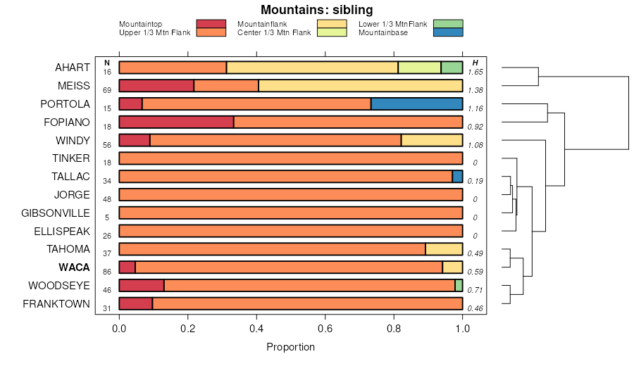
Waca-Meiss complex, 30 to 50 percent slopes | WDF | 25790 | 464834 | hlpn | ca719 | 1982 | 1:24000 |
Waca-Windy complex, 2 to 30 percent slopes *** | WAE | 21165 | 3233126 | 2zms1 | ca719 | 1982 | 1:24000 |
Waca-Windy complex, 30 to 50 percent slopes | WAF | 18609 | 464829 | hlph | ca719 | 1982 | 1:24000 |
Waca-Meiss complex, 2 to 30 percent slopes | WDE | 16695 | 464833 | hlpm | ca719 | 1982 | 1:24000 |
Meiss-Waca complex, 30 to 50 percent slopes | MKF | 14820 | 464749 | hllx | ca719 | 1982 | 1:24000 |
Waca-Meiss-Cryumbrepts, wet complex, 30 to 50 percent slopes | WEF | 13499 | 464836 | hlpq | ca719 | 1982 | 1:24000 |
Meiss-Waca-Cryumbrepts, wet complex, 30 to 75 percent slopes | MLG | 11598 | 464752 | hlm0 | ca719 | 1982 | 1:24000 |
Waca-Meiss-Cryumbrepts, wet complex, 2 to 30 percent slopes | WEE | 9484 | 464835 | hlpp | ca719 | 1982 | 1:24000 |
Waca-Humicryepts, wet-Windy complex, 30 to 50 percent slopes | WBF | 6335 | 3233128 | 2zms2 | ca719 | 1982 | 1:24000 |
Meiss-Waca-Rock outcrop complex, 30 to 50 percent slopes, severe ly eroded | MKF3 | 6299 | 464750 | hlly | ca719 | 1982 | 1:24000 |
Waca-Cryumbrepts, wet-Windy complex, 2 to 30 percent slopes | WBE | 6146 | 464830 | hlpj | ca719 | 1982 | 1:24000 |
Meiss-Waca complex, 2 to 30 percent slopes | MKE | 6016 | 464748 | hllw | ca719 | 1982 | 1:24000 |
Meiss-Waca-Cryumbrepts, wet complex, 2 to 30 percent slopes | MLE | 4544 | 464751 | hllz | ca719 | 1982 | 1:24000 |
Ahart-Waca, rhyolitic substratum-Cryumbrepts, wet complex, 2 to 30 percent slopes | ADE | 3925 | 464602 | hlg5 | ca719 | 1982 | 1:24000 |
Waca-Gullied land-Cryumbrepts, wet complex, 30 to 50 percent slo pes | WCF | 3703 | 464832 | hlpl | ca719 | 1982 | 1:24000 |
Ahart-Waca, rhyolitic substratum-Cryumbrepts, wet complex, 30 to 50 percent slopes | ADF | 3621 | 464603 | hlg6 | ca719 | 1982 | 1:24000 |
Ahart-Waca, rhyolitic substratum, 2 to 30 percent slopes | ACE | 3151 | 464600 | hlg3 | ca719 | 1982 | 1:24000 |
Ahart-Waca, rhyolitic substratum complex, 30 to 50 percent slopes | ACF | 2922 | 464601 | hlg4 | ca719 | 1982 | 1:24000 |
Jorge-Waca-Tahoma complex, 30 to 50 percent slopes | JWF | 1638 | 464708 | hlkl | ca719 | 1982 | 1:24000 |
Jorge-Waca-Cryumbrepts, wet complex, 2 to 30 percent slopes | JXE | 1319 | 464709 | hlkm | ca719 | 1982 | 1:24000 |
Jorge-Waca-Tahoma complex, 2 to 30 percent slopes | JWE | 764 | 464707 | hlkk | ca719 | 1982 | 1:24000 |
Jorge-Waca-Cryumbrepts, wet complex, 30 to 50 percent slopes | JXF | 485 | 464710 | hlkn | ca719 | 1982 | 1:24000 |
Rock outcrop-Waca, rhyolitic substratum-Ledmount variant complex ,2 to 30 percent slopes | RVE | 439 | 464792 | hln9 | ca719 | 1982 | 1:24000 |
Waca-Windy complex, 5 to 30 percent slopes | 216 | 10797 | 464965 | hltw | ca724 | 1985 | 1:24000 |
Waca cobbly sandy loam, 5 to 30 percent slopes | 211 | 7694 | 464960 | hltq | ca724 | 1985 | 1:24000 |
Lithic Cryumbrepts-Waca association, 5 to 30 percent slopes | 162 | 3265 | 464912 | hls5 | ca724 | 1985 | 1:24000 |
Ahart-Waca, rhyolitic substratum, 2 to 30 percent slopes complex | ACEtf | 3181 | 1591340 | 1qdxk | ca724 | 1985 | 1:24000 |
Waca cobbly sandy loam, 30 to 50 percent slopes | 212 | 2827 | 464961 | hltr | ca724 | 1985 | 1:24000 |
Waca-Lithic Cryumbrepts-Cryumbrepts, wet association 5 to 30 percent slopes | 214 | 1752 | 464963 | hltt | ca724 | 1985 | 1:24000 |
Waca-Windy complex, 30 to 50 percent slopes | 217 | 1663 | 464966 | hltx | ca724 | 1985 | 1:24000 |
Waca-Lithic Cryumbrepts association, 30 to 50 percent slopes | 213 | 1400 | 464962 | hlts | ca724 | 1985 | 1:24000 |
Lithic Cryumbrepts-Waca association, 30 to 50 percent slopes | 163 | 906 | 464913 | hls6 | ca724 | 1985 | 1:24000 |
Waca-Lithic Cryumbrepts-Cryumbrepts, wet association, 30 to 50 percent slopes | 215 | 336 | 464964 | hltv | ca724 | 1985 | 1:24000 |


