| Vitale-Cleavage-Bauscher complex, 5 to 50 percent slopes | 191 | 20793 | 486086 | j9t6 | id675 | 1992 | 1:24000 |
Vitale-Itca-Rubble land complex, 2 to 60 percent slopes | 192 | 20342 | 486088 | j9t8 | id675 | 1992 | 1:24000 |
Vitale-Mulshoe-Itca complex, 2 to 40 percent slopes | 193 | 11567 | 486089 | j9t9 | id675 | 1992 | 1:24000 |
Vitale-Rock outcrop complex, 5 to 40 percent slopes | 194 | 2356 | 486091 | j9tc | id675 | 1992 | 1:24000 |
Vitale very stony loam, 5 to 40 percent slopes | 190 | 929 | 486084 | j9t4 | id675 | 1992 | 1:24000 |
Povey-Vitale association, 30 to 60 percent slopes | 95 | 36048 | 79386 | 2nlv | id680 | 1985 | 1:24000 |
Vitale-Povey association, 30 to 60 percent slopes | 109 | 33683 | 79290 | 2nhr | id680 | 1985 | 1:24000 |
Vitale-Blackspar complex, 30 to 60 percent slopes | 107 | 19191 | 79288 | 2nhp | id680 | 1985 | 1:24000 |
Vitale-Milligan complex, 30 to 60 percent slopes | 108 | 18097 | 79289 | 2nhq | id680 | 1985 | 1:24000 |
Lavacreek-Vitale association, 30 to 60 percent slopes | 63 | 6019 | 79351 | 2nkq | id680 | 1985 | 1:24000 |
Povey-Vitale association, 30 to 60 percent slopes | 95-BL | 1212 | 3403228 | 2nlv | id700 | | 1:24000 |
Vitale-Povey association, 30 to 60 percent slopes | 109-BL | 419 | 3403213 | 2nhr | id700 | | 1:24000 |
Vitale-Milligan complex, 30 to 60 percent slopes | 108-BL | 100 | 3403212 | 2nhq | id700 | | 1:24000 |
Vitale-Povey association, 30 to 60 percent slopes | 109-BL | 66 | 3173602 | 2nhr | id703 | | 1:24000 |
Jimsage-Vitale association, 30 to 65 percent slopes | 87 | 14614 | 82563 | 2rxb | id708 | 1987 | 1:24000 |
Vitale-Jimsage association, 40 to 60 percent slopes | 154 | 9034 | 82473 | 2rtf | id708 | 1987 | 1:24000 |
Watercanyon-Vitale-Rexburg association, 30 to 50 percent slopes | 157 | 8978 | 82476 | 2rtj | id708 | 1987 | 1:24000 |
Drage-Vitale, stony surface-Broadhead association, 5 to 30 percent slopes | DGF | 9 | 3238965 | n4bk | id711 | 1983 | 1:24000 |
Hutchley-Cupine-Vitale complex, 2 to 60 percent slopes | 105 | 5120 | 3163502 | 2sltt | id712 | 2008 | 1:24000 |
Hutchley-Cupine-Vitale complex, 2 to 60 percent slopes | 105-BL | 1472 | 2917039 | 2sltt | id713 | | 1:24000 |
Bergquist-Vitale, extremely stony surface, complex, 15 to 60 percent slopes | 20-F | 639 | 3093892 | j8yn | id713 | | 1:24000 |
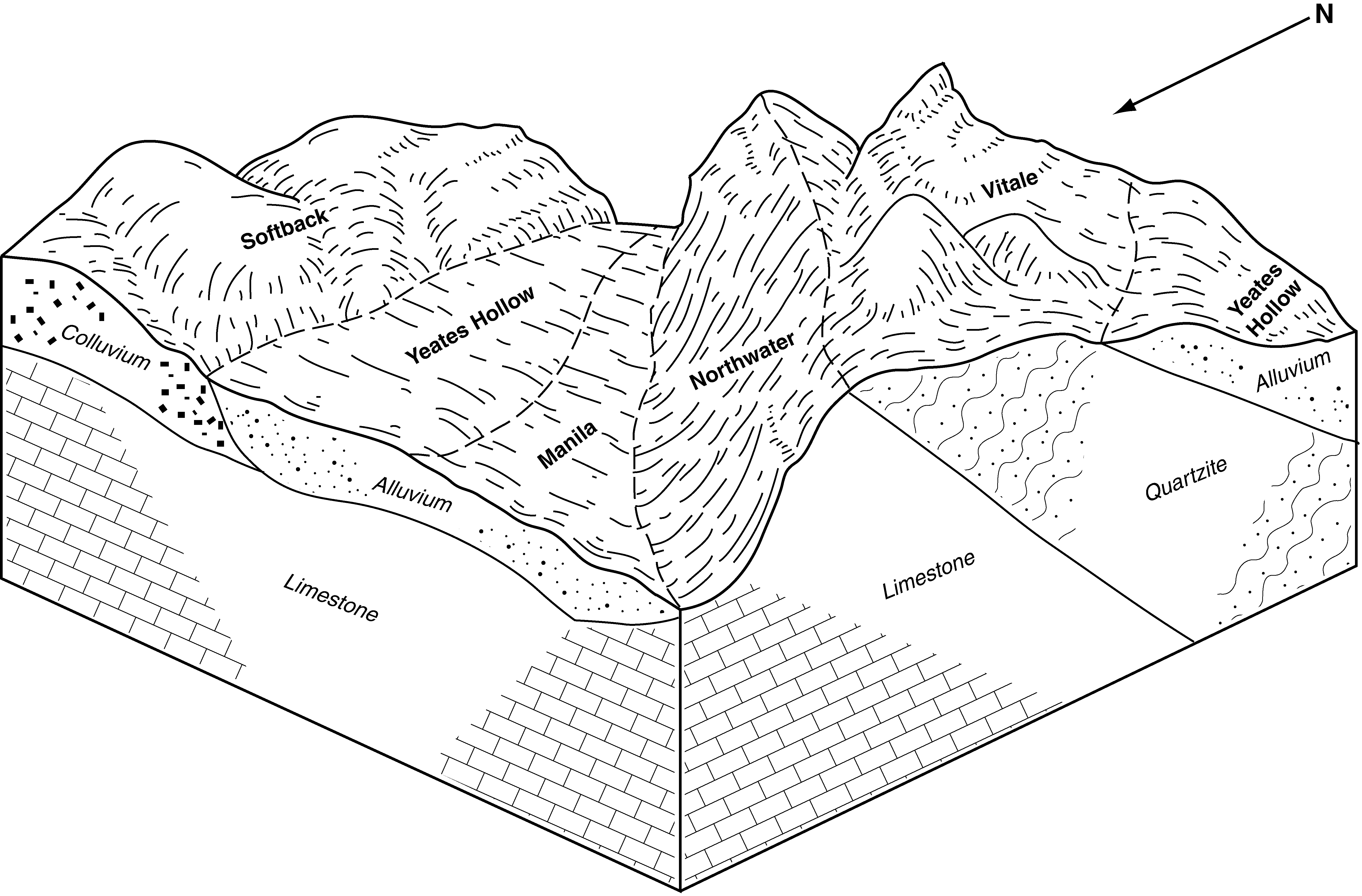
Vitale, extremely stony surface-Yeates Hollow, extremely stony surface-Northwater complex, 12 to 40 percent slopes | 145-F | 564 | 2619886 | 2v083 | id713 | | 1:24000 |
Northwater-Foxol, very stony surface-Vitale, extremely stony surface, complex, 50 to 80 percent slopes | 100-F | 538 | 3163485 | 2yy4b | id713 | | 1:24000 |
Vitale, extremely stony surface-Bergquist-Rock outcrop complex, 30 to 60 percent slopes | 144 | 292 | 2965715 | 2x033 | id713 | | 1:24000 |
Vitale, extremely stony surface-Yeates Hollow, extremely stony surface-Northwater complex, 12 to 40 percent slopes | 145 | 4646 | 3163581 | 2v083 | id714 | 1997 | 1:24000 |
Foxol, very stony surface-Vitale, extremely stony surface complex, 20 to 55 percent slopes | 45 | 3909 | 485290 | j8zj | id714 | 1997 | 1:24000 |
Vitale, extremely stony surface-Bergquist-Rock outcrop complex, 30 to 60 percent slopes | 144 | 3786 | 3163580 | 2x033 | id714 | 1997 | 1:24000 |
Yeates Hollow-Vitale complex, 25 to 50 percent slopes | 163 | 3738 | 485257 | j8yg | id714 | 1997 | 1:24000 |
Bergquist-Vitale, extremely stony surface, complex, 15 to 60 percent slopes | 20 | 2818 | 485263 | j8yn | id714 | 1997 | 1:24000 |
Hondoho-Vitale complex, 20 to 50 percent slopes | 56 | 1057 | 485302 | j8zx | id714 | 1997 | 1:24000 |
Northwater-Foxol, very stony surface-Vitale, extremely stony surface, complex, 50 to 80 percent slopes | 100 | 872 | 3163574 | 2yy4b | id714 | 1997 | 1:24000 |
Hutchley-Cupine-Vitale complex, 2 to 60 percent slopes | 105-BL | 88 | 3173325 | 2sltt | id714 | 1997 | 1:24000 |
Vitale, extremely stony surface-Bergquist-Rock outcrop complex, 30 to 60 percent slopes | 144 | 926 | 2984137 | 2x033 | id716 | | 1:24000 |
Drage-Vitale, stony surface-Broadhead association, 5 to 30 percent slopes | DGF | 594 | 599991 | n4bk | id716 | | 1:24000 |
Foxol, very stony surface-Vitale, extremely stony surface, complex, 20 to 55 percent slopes | 45 | 217 | 2984138 | 2v07v | id716 | | 1:24000 |
Vitale-Blackspar complex, 5 to 60 percent slopes | 134 | 4183 | 78962 | 2n55 | id763 | 1998 | 1:24000 |
Lavacreek-Vitale association, 30 to 60 percent slopes | 55 | 1971 | 79074 | 2n8s | id763 | 1998 | 1:24000 |
Vitale-Blackspar complex, 30 to 60 percent slopes | 150 | 554 | 1652495 | 1sgk9 | id763 | 1998 | 1:24000 |
Vitale-Blackspar complex, 30 to 60 percent slopes | 84 | 2908 | 78914 | 2n3m | id780 | 1998 | 1:24000 |
Lavacreek-Vitale association, 30 to 60 percent slopes | 35 | 1406 | 78916 | 2n3p | id780 | 1998 | 1:24000 |
Chen-Vitale association | 744 | 3180 | 2928276 | 2w2vw | nv764 | 2021 | 1:24000 |
Cleavage extremely gravelly loam-Cleavage-Vitale association | 742 | 11358 | 475100 | hyct | nv765 | 1986 | 1:24000 |
Gollaher-Shalcleav-Vitale association | 806 | 7595 | 475135 | hydy | nv765 | 1986 | 1:24000 |
Chen-Vitale association | 744 | 7370 | 475102 | 2w2vw | nv765 | 1986 | 1:24000 |
Cleavage-Vitale association | 234 | 3610 | 2633840 | 2rgmf | nv765 | 1986 | 1:24000 |
Chen-Shalcleav-Vitale association | 474 | 2600 | 475041 | hy9x | nv765 | 1986 | 1:24000 |
Gollaher-Arcia-Vitale association | 799 | 1350 | 475130 | hyds | nv765 | 1986 | 1:24000 |
Sumine-Vitale-Bullvaro association | 582 | 10722 | 478961 | j2dc | nv767 | 1986 | 1:24000 |
Cleavage-Vitale association | 239 | 3347 | 478847 | j28p | nv767 | 1986 | 1:24000 |
Heechee-Manard-Vitale association | 2070 | 671 | 478821 | j27v | nv767 | 1986 | 1:24000 |
Vitale-Ebic-Chen association | 3000 | 277 | 478869 | j29d | nv767 | 1986 | 1:24000 |
Vitale-Merlin-Doyn complex, 2 to 20 percent slopes | 4405AO | 295 | 3385429 | jgpd | or626 | 2018 | 1:24000 |
Vitale-Merlin complex, 2 to 20 percent slopes | 343 | 34148 | 490772 | jgpc | or628 | 1997 | 1:24000 |
Vitale-Merlin-Doyn complex, 2 to 20 percent slopes | 344 | 23952 | 490773 | jgpd | or628 | 1997 | 1:24000 |
Vitale very stony loam, 5 to 20 percent slopes | 342 | 12029 | 490771 | jgpb | or628 | 1997 | 1:24000 |
Vitale-Observation complex, 2 to 20 percent slopes | 345 | 3481 | 490774 | jgpf | or628 | 1997 | 1:24000 |
Vitale-Rock outcrop complex, 20 to 60 percent south slopes | 346 | 2261 | 490775 | jgpg | or628 | 1997 | 1:24000 |
Vitale very cobbly sandy loam, 5 to 20 percent slopes | 650 | 8072 | 1690150 | 1tqqz | or635 | 2006 | 1:24000 |
Vitale-Bullump complex, 5 to 30 percent slopes | 259E | 3977 | 489122 | jdz4 | or636 | 1991 | 1:24000 |
Vitale-Doyn-Merlin complex, 5 to 25 percent slopes | 9023 | 23370 | 2722268 | 2sf3b | or645 | | 1:24000 |
Bullump-Vitale complex, 30 to 60 percent north slopes | 9014 | 9881 | 2564851 | 2qxy0 | or645 | | 1:24000 |
Bocker-Vitale-Pernog complex, 20 to 40 percent slopes | 9026 | 9467 | 2722271 | 2sf37 | or645 | | 1:24000 |
Shepridge-Vitale complex, 15 to 50 percent slopes | 8022 | 2575 | 2981380 | 2tjt7 | ut608 | 1981 | 1:24000 |
Cedarpoint-Onaqui-Vitale complex, 15 to 50 percent slopes | 8004 | 1990 | 2981366 | 2tjsn | ut608 | 1981 | 1:24000 |
Shepridge-Butterfield-Vitale complex, 8 to 30 percent slopes | 8021 | 705 | 2981379 | 2tjt6 | ut608 | 1981 | 1:24000 |
Cedarpoint-Onaqui-Vitale complex, 15 to 50 percent slopes | 8004 | 3371 | 2981384 | 2tjsn | ut612 | 1967 | 1:20000 |
Shepridge-Vitale complex, 15 to 50 percent slopes | 8022 | 990 | 2981393 | 2tjt7 | ut612 | 1967 | 1:20000 |
Shepridge-Butterfield-Vitale complex, 8 to 30 percent slopes | 8021 | 248 | 2981392 | 2tjt6 | ut612 | 1967 | 1:20000 |