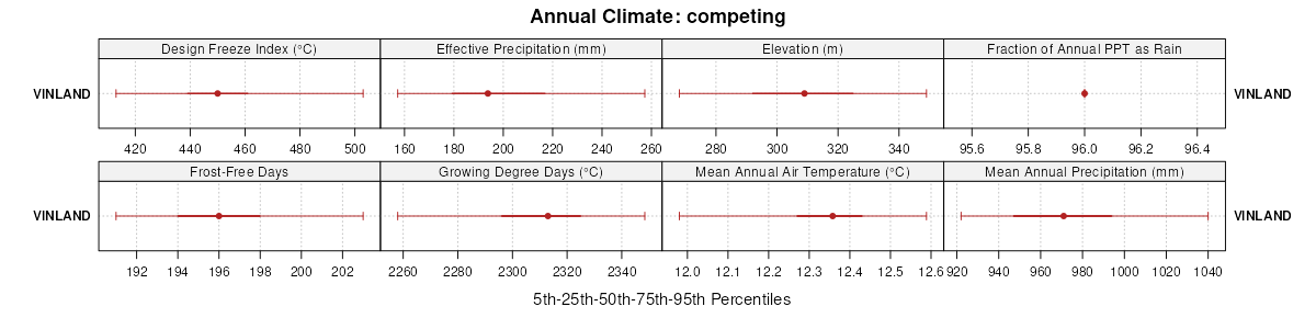
| Vinland silty clay loam, 4 to 15 percent slopes | 7655 | 3801 | 1475374 | 2yrvs | ks005 | 1998 | 1:24000 |
Vinland-Rock outcrop complex, 15 to 45 percent slopes | 7658 | 861 | 1475375 | 2yrvt | ks005 | 1998 | 1:24000 |
Bendena-Vinland complex, 8 to 30 percent slopes | 7216 | 101 | 1480279 | 1lpby | ks005 | 1998 | 1:24000 |
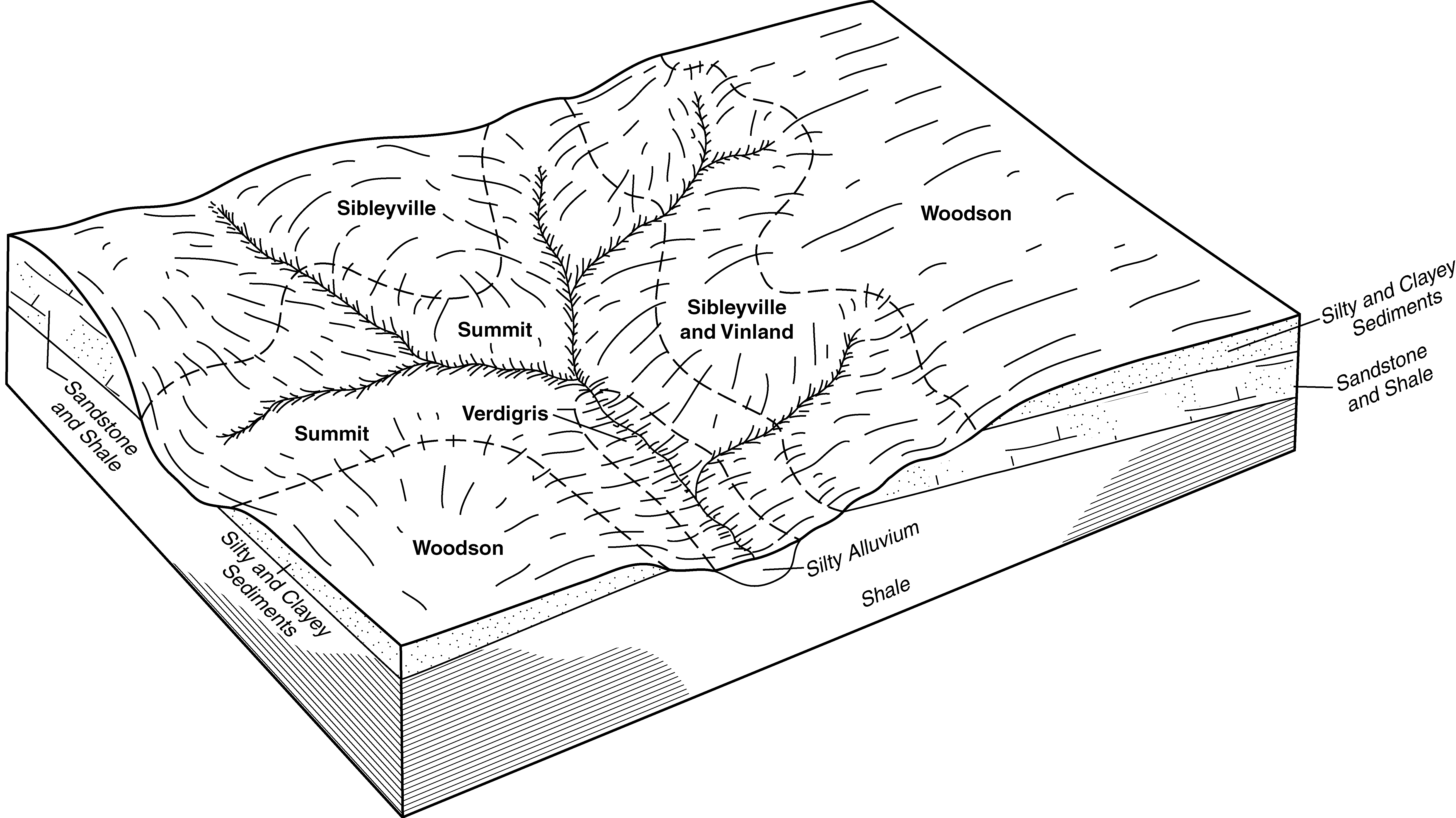
Vinland-Sibleyville complex, 7 to 15 percent slopes | 7666 | 96 | 2420328 | 2yrvz | ks005 | 1998 | 1:24000 |
Wamego-Vinland silty clay loams, 3 to 15 percent slopes | 4834 | 95 | 1475347 | 2vhh3 | ks005 | 1998 | 1:24000 |
Wallula-Vinland complex, 5 to 40 percent slopes | 7672 | 94 | 2420336 | 2x6bv | ks005 | 1998 | 1:24000 |
Sogn-Vinland complex, 3 to 25 percent slopes | 4752 | 12 | 1480270 | 2wvzj | ks005 | 1998 | 1:24000 |
Wamego-Vinland silty clay loams, 3 to 15 percent slopes | 4834 | 5032 | 1152156 | 2vhh3 | ks013 | 1994 | 1:24000 |
Bendena-Vinland complex, 8 to 30 percent slopes | 7216 | 2295 | 747153 | t2gq | ks043 | 1977 | 1:24000 |
Wamego-Vinland silty clay loams, 3 to 15 percent slopes | 4834 | 13 | 747191 | 2vhh3 | ks043 | 1977 | 1:24000 |
Vinland-Martin complex, 7 to 15 percent slopes | 7657 | 18899 | 1468857 | 2yrw2 | ks045 | 1974 | 1:24000 |
Sogn-Vinland complex, 3 to 25 percent slopes | 4752 | 14454 | 1468812 | 2wvzj | ks045 | 1974 | 1:24000 |
Vinland-Rock outcrop complex, 15 to 45 percent slopes | 7658 | 10936 | 1468858 | 2yrvt | ks045 | 1974 | 1:24000 |
Vinland complex, 3 to 7 percent slopes | 7651 | 3968 | 1468855 | 2yrvp | ks045 | 1974 | 1:24000 |
Vinland complex, 3 to 7 percent slopes, eroded | 7652 | 857 | 1468856 | 2yrvq | ks045 | 1974 | 1:24000 |
Sibleyville-Vinland loams, 3 to 7 percent slopes | 7607 | 66 | 1468853 | 1l9gc | ks045 | 1974 | 1:24000 |
Vinland loam, 3 to 12 percent slopes | 7654 | 16 | 1453662 | 31c46 | ks073 | 1981 | 1:24000 |
Martin-Vinland silty clay loams, 5 to 10 percent slopes | 7330 | 24210 | 1480352 | 2v8zy | ks085 | 1976 | 1:24000 |
Vinland-Sogn complex, 5 to 15 percent slopes | 7660 | 7924 | 1480373 | 2wvzl | ks085 | 1976 | 1:24000 |
Vinland silty clay loam, 4 to 15 percent slopes | 7655 | 3119 | 1480371 | 2yrvs | ks085 | 1976 | 1:24000 |
Vinland-Rock outcrop complex, 15 to 45 percent slopes | 7658 | 1841 | 1480372 | 2yrvt | ks085 | 1976 | 1:24000 |
Sogn-Vinland complex, 3 to 25 percent slopes | 4752 | 950 | 1480329 | 2wvzj | ks085 | 1976 | 1:24000 |
Vinland complex, 3 to 7 percent slopes | 7651 | 164 | 1480369 | 2yrvp | ks085 | 1976 | 1:24000 |
Wamego-Vinland silty clay loams, 3 to 15 percent slopes | 4834 | 71 | 1480331 | 2vhh3 | ks085 | 1976 | 1:24000 |
Vinland complex, 7 to 15 percent slopes | 7653 | 7 | 1480370 | 2yrvr | ks085 | 1976 | 1:24000 |
Vinland complex, 7 to 15 percent slopes | 7653 | 20366 | 1480077 | 2yrvr | ks087 | 1974 | 1:24000 |
Vinland-Rock outcrop complex, 15 to 45 percent slopes | 7658 | 16013 | 1480080 | 2yrvt | ks087 | 1974 | 1:24000 |
Sogn-Vinland complex, 3 to 25 percent slopes | 4752 | 11718 | 1480030 | 2wvzj | ks087 | 1974 | 1:24000 |
Vinland complex, 3 to 7 percent slopes | 7651 | 9103 | 1480076 | 2yrvp | ks087 | 1974 | 1:24000 |
Vinland-Rock outcrop complex, 15 to 40 percent slopes | 7667 | 1488 | 2420331 | 2yrw0 | ks087 | 1974 | 1:24000 |
Vinland-Sibleyville complex, 7 to 15 percent slopes | 7666 | 1454 | 2420329 | 2yrvz | ks087 | 1974 | 1:24000 |
Vinland-Sibleyville complex, 3 to 7 percent slopes | 7665 | 265 | 2420327 | 2yrvy | ks087 | 1974 | 1:24000 |
Vinland silty clay loam, 4 to 15 percent slopes | 7655 | 169 | 1480078 | 2yrvs | ks087 | 1974 | 1:24000 |
Vinland-Martin complex, 7 to 15 percent slopes | 7657 | 164 | 1480079 | 2yrw2 | ks087 | 1974 | 1:24000 |
Wallula-Vinland complex, 5 to 40 percent slopes | 7672 | 162 | 2420335 | 2x6bv | ks087 | 1974 | 1:24000 |
Martin-Vinland silty clay loams, 5 to 10 percent slopes | 7330 | 25 | 1480059 | 2v8zy | ks087 | 1974 | 1:24000 |
Sogn-Vinland complex, 3 to 25 percent slopes | 4752 | 13795 | 766074 | 2wvzj | ks091 | 1976 | 1:24000 |
Vinland-Rock outcrop complex, 15 to 45 percent slopes | 7658 | 9069 | 766075 | 2yrvt | ks091 | 1976 | 1:24000 |
Sibleyville-Vinland loams, 3 to 7 percent slopes | 7607 | 1576 | 766073 | tq51 | ks091 | 1976 | 1:24000 |
Martin-Vinland silty clay loams, 5 to 10 percent slopes | 7330 | 1448 | 766061 | 2v8zy | ks091 | 1976 | 1:24000 |
Vinland-Sibleyville complex, 7 to 15 percent slopes | 7666 | 4802 | 2420330 | 2yrvz | ks103 | 1973 | 1:24000 |
Wallula-Vinland complex, 5 to 40 percent slopes | 7672 | 1916 | 2420334 | 2x6bv | ks103 | 1973 | 1:24000 |
Vinland-Sibleyville complex, 5 to 12 percent slopes | 7659 | 1906 | 1862398 | 2yrvv | ks103 | 1973 | 1:24000 |
Vinland-Sibleyville complex, 3 to 7 percent slopes | 7665 | 1453 | 2420326 | 2yrvy | ks103 | 1973 | 1:24000 |
Vinland-Rock outcrop complex, 15 to 40 percent slopes | 7667 | 1417 | 2420332 | 2yrw0 | ks103 | 1973 | 1:24000 |
Vinland loam, 3 to 12 percent slopes | 7654 | 1095 | 1453727 | 31c46 | ks111 | 1977 | 1:24000 |
Vinland variant loam, 5 to 25 percent slopes | 7656 | 475 | 1406033 | 2yrw1 | ks131 | 1980 | 1:24000 |
Sogn-Vinland complex, 3 to 25 percent slopes | 4752 | 2420 | 1454762 | 2wvzj | ks139 | 1983 | 1:24000 |
Vinland-Martin complex, 7 to 15 percent slopes | 7657 | 434 | 1454778 | 2yrw2 | ks139 | 1983 | 1:24000 |
Vinland-Rock outcrop complex, 15 to 45 percent slopes | 7658 | 188 | 1454779 | 2yrvt | ks139 | 1983 | 1:24000 |
Vinland-Sogn complex, 15 to 45 percent slopes | 7661 | 167 | 1454780 | 2wvzm | ks139 | 1983 | 1:24000 |
Sogn-Vinland complex, 3 to 25 percent slopes | 4752 | 30534 | 1473462 | 2wvzj | ks177 | 1966 | 1:24000 |
Vinland-Rock outcrop complex, 15 to 45 percent slopes | 7658 | 5986 | 1473531 | 2yrvt | ks177 | 1966 | 1:24000 |
Vinland silty clay loam, 4 to 15 percent slopes | 7655 | 1747 | 1473529 | 2yrvs | ks177 | 1966 | 1:24000 |
Vinland-Sogn complex, 15 to 45 percent slopes | 7661 | 239 | 1532315 | 2wvzm | ks177 | 1966 | 1:24000 |
Vinland-Martin complex, 7 to 15 percent slopes | 7657 | 69 | 1473530 | 2yrw2 | ks177 | 1966 | 1:24000 |
Martin-Vinland silty clay loams, 5 to 10 percent slopes | 7330 | 13 | 1473503 | 2v8zy | ks177 | 1966 | 1:24000 |
Sogn-Vinland complex, 3 to 25 percent slopes | 4752 | 69 | 1472148 | 2wvzj | ks197 | 1988 | 1:24000 |
Vinland-Rock outcrop complex, 15 to 45 percent slopes | 7658 | 1416 | 1862285 | 2yrvt | ks209 | 1973 | 1:24000 |
Vinland-Sibleyville complex, 5 to 12 percent slopes | 7659 | 396 | 1862286 | 2yrvv | ks209 | 1973 | 1:24000 |