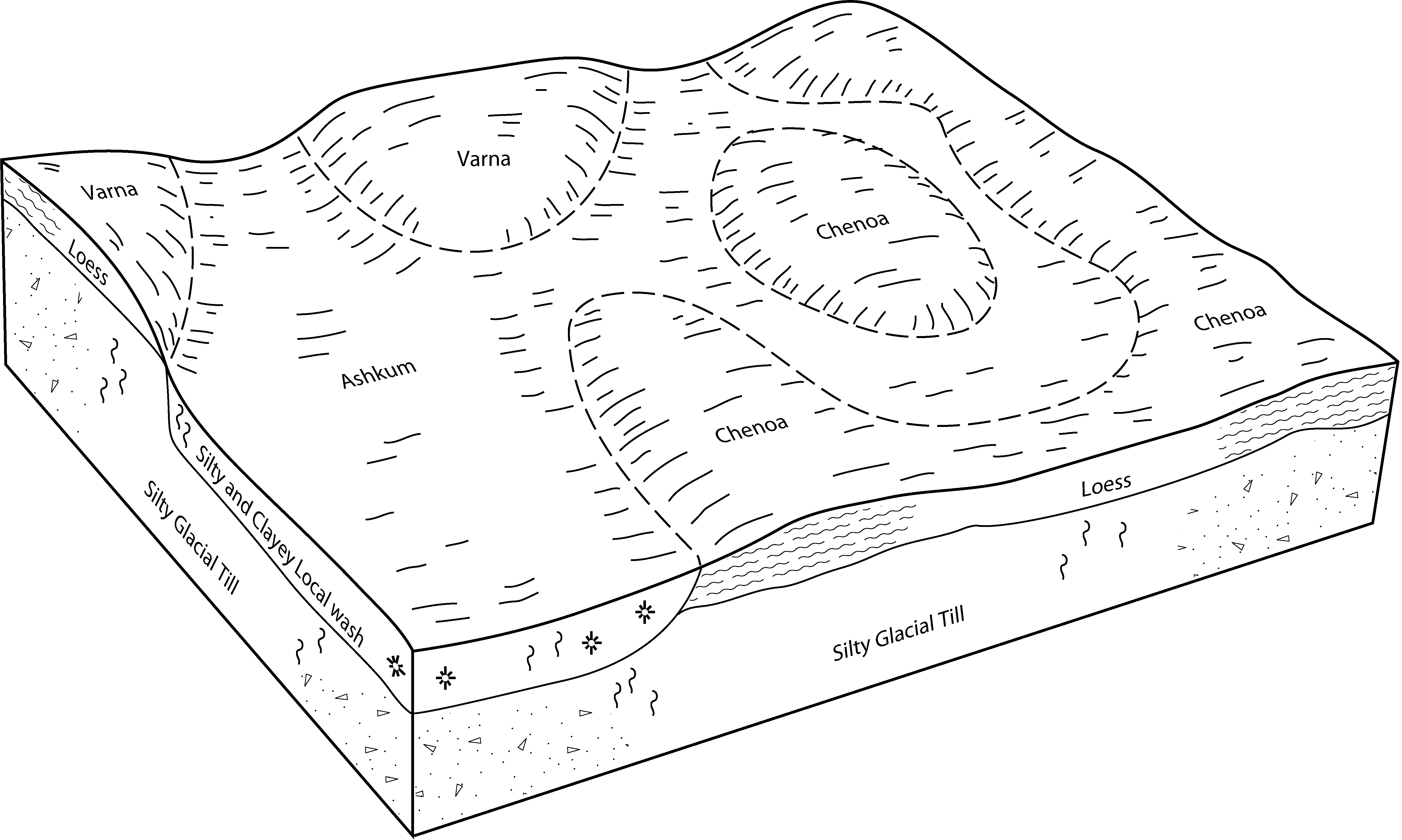
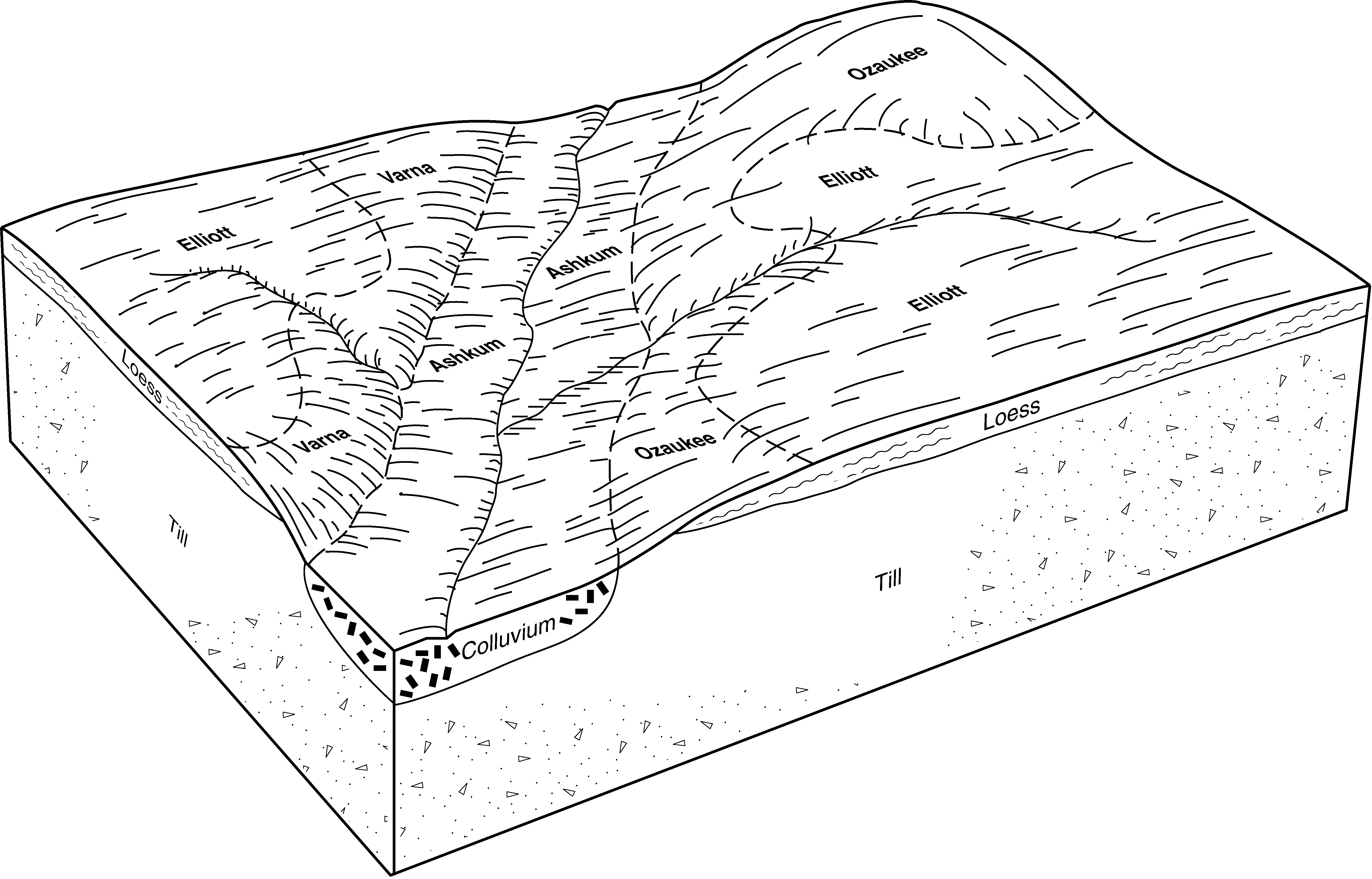
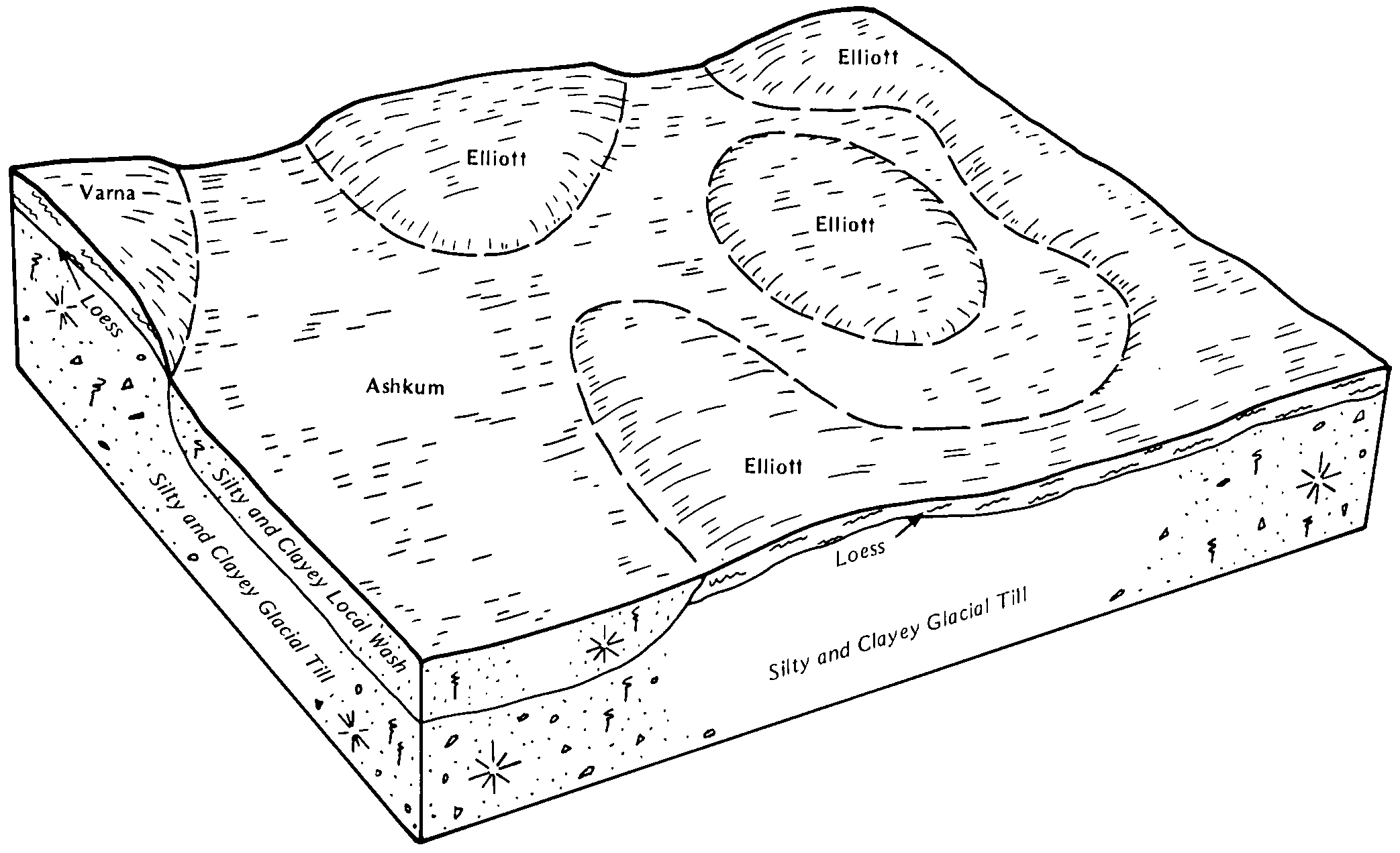
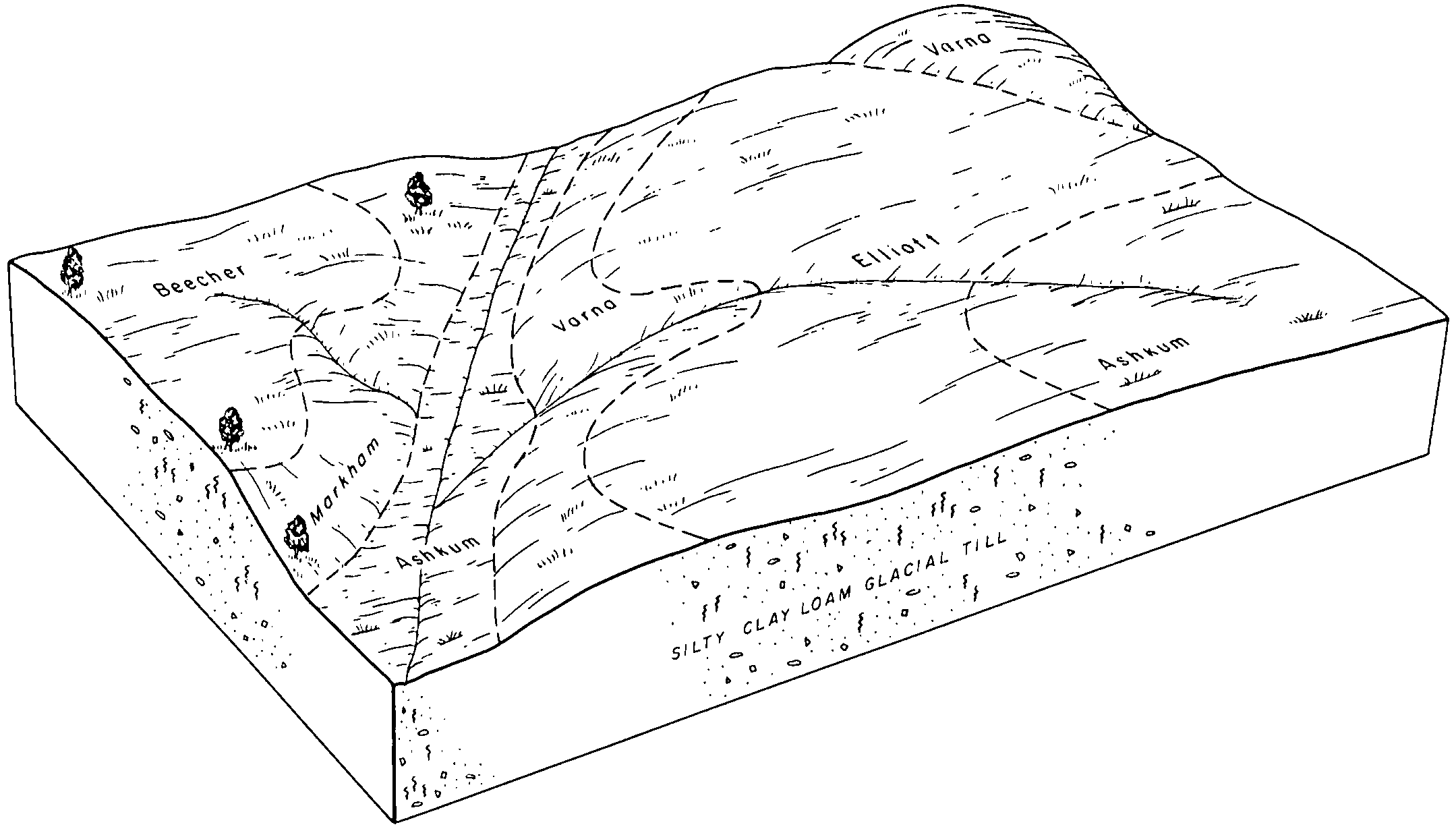
Official Series Description


Lab Data Summary

Aggregate lab data for the VARNA soil series. This aggregation is based on all pedons with a current taxon name of VARNA, and applied along 1-cm thick depth slices. Solid lines are the slice-wise median, bounded on either side by the interval defined by the slice-wise 5th and 95th percentiles. The median is the value that splits the data in half. Five percent of the data are less than the 5th percentile, and five percent of the data are greater than the 95th percentile. Values along the right hand side y-axis describe the proportion of pedon data that contribute to aggregate values at this depth. For example, a value of "90%" at 25cm means that 90% of the pedons correlated to VARNA were used in the calculation. Source: KSSL snapshot . Methods used to assemble the KSSL snapshot used by SoilWeb / SDE

Click the image to view it full size.

Pedons used in the lab summary:

MLRALab IDPedon IDTaxonnameCINSSL / NASIS ReportsLink To SoilWeb GMap
108A87IL1131031987IL113103Varna2Primary | Supplementary | Taxonomy | Pedon | Water Retention | Correlation | Andic Soil Properties40.4479944,-88.7696389
108A89IL1130071989IL113007Varna2Primary | Supplementary | Taxonomy | Pedon | Water Retention | Correlation | Andic Soil Properties40.360525,-88.4659722
108A89IL1130091989IL113009Varna2Primary | Supplementary | Taxonomy | Pedon | Water Retention | Correlation | Andic Soil Properties40.3693278,-88.5363778
11077IL0190291977IL019029Varna1Primary | Supplementary | Taxonomy | Pedon | Water Retention | Correlation | Andic Soil Properties40.3992642,-88.2636399
11077IL0750021977IL075002Varna1Primary | Supplementary | Taxonomy | Pedon | Water Retention | Correlation | Andic Soil Properties40.9849776,-88.0090234
11079IL0750121979IL075012Varna1Primary | Supplementary | Taxonomy | Pedon | Water Retention | Correlation | Andic Soil Properties40.9837859,-88.0992736
11079IL0750131979IL075013Varna1Primary | Supplementary | Taxonomy | Pedon | Water Retention | Correlation | Andic Soil Properties40.9852776,-88.0552833
11086IL1130111986IL113011Varna2Primary | Supplementary | Taxonomy | Pedon | Water Retention | Correlation | Andic Soil Properties40.7325333,-88.6147417
11086IL1130121986IL113012Varna2Primary | Supplementary | Taxonomy | Pedon | Water Retention | Correlation | Andic Soil Properties40.6593361,-88.6406167
11086IL1130251986IL113025Varna4Primary | Supplementary | Taxonomy | Pedon | Water Retention | Correlation | Andic Soil Properties40.6852389,-88.7424556
11086IL1130271986IL113027Varna4Primary | Supplementary | Taxonomy | Pedon | Water Retention | Correlation | Andic Soil Properties40.7562639,-88.6712583
11088IL1050051988IL105005Varna1Primary | Supplementary | Taxonomy | Pedon | Water Retention | Correlation | Andic Soil Properties41.0203528,-88.5155333
11040A1607S1958WI101001Varna6Primary | Supplementary | Taxonomy | Pedon | Water Retention | Correlation | Andic Soil Properties42.751667,-87.9383316
11040A1608S1958WI101002Varna6Primary | Supplementary | Taxonomy | Pedon | Water Retention | Correlation | Andic Soil Properties42.6824989,-87.8930588
11008N0631S2008IL091001Varna7Primary | Supplementary | Taxonomy | Pedon | Water Retention | Correlation | Andic Soil Properties41.0139198,-88.0137177
111CWH75011975IN181001Varna2Primary | Supplementary | Taxonomy | Pedon | Water Retention | Correlation | Andic Soil Properties40.6537889,-87.0537028
111CWH76291976IN181029Varna3Primary | Supplementary | Taxonomy | Pedon | Water Retention | Correlation | Andic Soil Properties40.6546972,-87.0515444
n/a76IL0190061976IL019006Varna1Primary | Supplementary | Taxonomy | Pedon | Water Retention | Correlation | Andic Soil Propertiesn/a

Water Balance

Monthly water balance estimated using a leaky-bucket style model for the VARNA soil series. Monthly precipitation (PPT) and potential evapotranspiration (PET) have been estimated from the 50th percentile of gridded values (PRISM 1981-2010) overlapping with the extent of SSURGO map units containing each series as a major component. Monthly PET values were estimated using the method of Thornthwaite (1948). These (and other) climatic parameters are calculated with each SSURGO refresh and provided by the fetchOSD function of the soilDB package. Representative water storage values (“AWC” in the figures) were derived from SSURGO by taking the 50th percentile of profile-total water storage (sum[awc_r * horizon thickness]) for each soil series. Note that this representation of “water storage” is based on the average ability of most plants to extract soil water between 15 bar (“permanent wilting point”) and 1/3 bar (“field capacity”) matric potential. Soil moisture state can be roughly interpreted as “dry” when storage is depleted, “moist” when storage is between 0mm and AWC, and “wet” when there is a surplus. Clearly there are a lot of assumptions baked into this kind of monthly water balance. This is still a work in progress.

Click the image to view it full size.


Click the image to view it full size.

Sibling Summary

Siblings are those soil series that occur together in map units, in this case with the VARNA series. Sketches are arranged according to their subgroup-level taxonomic structure. Source: SSURGO snapshot , parsed OSD records and snapshot of SC database .

Click the image to view it full size.

Select annual climate data summaries for the VARNA series and siblings. Series are sorted according to hierarchical clustering of median values. Source: SSURGO map unit geometry and 1981-2010, 800m PRISM data .

Click the image to view it full size.

Geomorphic description summaries for the VARNA series and siblings. Series are sorted according to hierarchical clustering of proportions and relative hydrologic position within an idealized landform (e.g. top to bottom). Most soil series (SSURGO components) are associated with a hillslope position and one or more landform-specific positions: hills, mountain slopes, terraces, and/or flats. Proportions can be interpreted as an aggregate representation of geomorphic membership. The values printed to the left (number of component records) and right (Shannon entropy) of stacked bars can be used to judge the reliability of trends. Small Shannon entropy values suggest relatively consistent geomorphic association, while larger values suggest lack thereof. Source: SSURGO component records .

Click the image to view it full size.

Click the image to view it full size.

There are insufficient data to create the 3D mountains figure.

Click the image to view it full size.

Click the image to view it full size.

Competing Series

Soil series competing with VARNA share the same family level classification in Soil Taxonomy. Source: parsed OSD records and snapshot of the SC database .

Click the image to view it full size.

Select annual climate data summaries for the VARNA series and competing. Series are sorted according to hierarchical clustering of median values. Source: SSURGO map unit geometry and 1981-2010, 800m PRISM data .

There are insufficient data to create the annual climate figure.

Geomorphic description summaries for the VARNA series and competing. Series are sorted according to hierarchical clustering of proportions and relative hydrologic position within an idealized landform (e.g. top to bottom). Proportions can be interpreted as an aggregate representation of geomorphic membership. Most soil series (SSURGO components) are associated with a hillslope position and one or more landform-specific positions: hills, mountain slopes, terraces, and/or flats. The values printed to the left (number of component records) and right (Shannon entropy) of stacked bars can be used to judge the reliability of trends. Shannon entropy values close to 0 represent soil series with relatively consistent geomorphic association, while values close to 1 suggest lack thereof. Source: SSURGO component records .

There are insufficient data to create the 2D hillslope position figure.

There are insufficient data to create the 3D hills figure.

There are insufficient data to create the 3D mountains figure.

There are insufficient data to create the 3D terrace figure.

There are insufficient data to create the 3D flats position figure.

Soil series sharing subgroup-level classification with VARNA, arranged according to family differentiae. Hovering over a series name will print full classification and a small sketch from the OSD. Source: snapshot of SC database .

Block Diagrams

Click a link below to display the diagram. Note that these diagrams may be from multiple survey areas.

  1. IL-2010-09-01-36 | Livingston County - 1996

    Typical pattern of soils and parent material in the Elliot-Ashkum association (Soil Survey of Livingston County, Illinois; 1996).

  2. IL-2010-09-01-41 | Marshall County - 2002

    Typical pattern of soils and parent material in the Flanagan-Graymont-Elpaso association (Soil Survey of Marshall County, Illinois; 2002).

  3. IL-2010-09-01-60 | McLean County - 1998

    Typical pattern of soils and parent material in the Chenoa-Ashkum-Varna association (Soil Survey of McLean County, Illinois; 1998).

  4. IL-2010-09-24-09 | Champaign County -

    Typical pattern of soils and parent material in the MLRA 110 - Northern Illinois and Indiana Heavy Till Plain (Soil Survey of Champaign County, Illinois).

  5. IL-2011-08-04-11 | Ford County - 1990

    Typical pattern of soils and parent material in the Elliott-Ashkum association (Soil Survey of Ford County, Illinois; 1990).

  6. IL-2011-08-04-38 | Kankakee County - 1991

    Typical pattern of soils in Elliott-Varna-Ashkum association (Soil Survey of Kankakee County, Illinois; 1991).

  7. IL-2011-08-04-53 | Livingston County - 1996

    Typical pattern of soils and parent material in the Elliott-Ashkum association (Soil Survey of Livingston County, Illinois; 1996).

  8. IN-2012-01-19-05 | Benton County - 1989

    Pattern of soils and parent material in the Elliot-Ashkum-Selma, moderately fine substratum, association (Soil Survey of Benton County, Indiana; 1989).

Map Units

Map units containing VARNA as a major component. Limited to 250 records.

Map Unit Name Symbol Map Unit Area (ac) Map Unit Key National Map Unit Symbol Soil Survey Area Publication Date Map Scale
Varna silt loam, 2 to 4 percent slopes223B90813972302yrqtil00720061:12000
Varna silt loam, 6 to 12 percent slopes, eroded223D246818629082yrqxil01120071:12000
Varna silty clay loam, 12 to 20 percent slopes, severely eroded223E322518629102zss6il01120071:12000
Varna silt loam, 2 to 4 percent slopes, eroded223B280412430222yrqvil01919991:12000
Varna silt loam, 4 to 6 percent slopes, eroded223C231162430132yrqwil01919991:12000
Varna silty clay loam, 6 to 12 percent slopes, severely eroded223D328282429732yrqzil01919991:12000
Varna silt loam, 2 to 4 percent slopes223B321821087282yrqtil03120081:12000
Anthroportic Udorthents-Urban land-Varna complex, 2 to 4 percent slopes2223B164025181692yrr5il03120081:12000
Varna silt loam, 4 to 6 percent slopes, eroded223C236621087292yrqwil03120081:12000
Varna silt loam, 2 to 4 percent slopes223B74051833752yrqtil04319981:12000
Varna silt loam, 4 to 6 percent slopes, eroded223C214291833762yrqwil04319981:12000
Varna silt loam, 2 to 4 percent slopes, eroded223B26681983382yrqvil05320011:12000
Varna silt loam, 4 to 6 percent slopes, eroded223C25471983362yrqwil05320011:12000
Varna silty clay loam, 4 to 6 percent slopes, severely eroded223C383013844632yrqyil06320051:12000
Varna silt loam, 2 to 4 percent slopes, eroded223B258515409182yrqvil06320051:12000
Varna silt loam, 2 to 4 percent slopes223B42011439952yrqtil06320051:12000
Varna silt loam, 4 to 6 percent slopes, eroded223C232013844572yrqwil06320051:12000
Varna silt loam, 2 to 4 percent slopes223B13941755602yrqtil07519801:15840
Varna silt loam, 2 to 4 percent slopes223B53241988192yrqtil08920001:12000
Varna silt loam, 4 to 6 percent slopes, eroded223C215041988202yrqwil08920001:12000
Varna silt loam, 2 to 4 percent slopes223B49339803712yrqtil09120031:12000
Varna silt loam, 2 to 4 percent slopes, eroded223B236939804422yrqvil09120031:12000
Varna silty clay loam, 4 to 6 percent slopes, severely eroded223C336559804452yrqyil09120031:12000
Varna silt loam, 4 to 6 percent slopes, eroded223C2609804432yrqwil09120031:12000
Varna silt loam, 4 to 6 percent slopes, eroded223C2156517156142yrqwil09320071:12000
Varna silty clay loam, 4 to 6 percent slopes, severely eroded223C334918690152yrqyil09320071:12000
Varna silty clay loam, 6 to 12 percent slopes, severely eroded223D32866387592yrqzil09320071:12000
Varna silt loam, 2 to 4 percent slopes223B24817150932yrqtil09320071:12000
Varna silt loam, 2 to 4 percent slopes, eroded223B27418971552yrqvil09320071:12000
Varna silt loam, 2 to 4 percent slopes223B40788033612yrqtil09720031:12000
Varna silt loam, 4 to 6 percent slopes, eroded223C228848033622yrqwil09720031:12000
Barrington and Varna silt loams, 2 to 4 percent slopes984B2626809247w52ril09720031:12000
Varna silt loam, 4 to 6 percent slopes, eroded223C2702310301142yrqwil09920061:12000
Varna silty clay loam, 4 to 6 percent slopes, severely eroded223C3205413862182yrqyil09920061:12000
Varna silty clay loam, 6 to 12 percent slopes, severely eroded223D3128614261362yrqzil09920061:12000
Varna silt loam, 2 to 4 percent slopes, eroded223B2109314261332yrqvil09920061:12000
Varna silt loam, 6 to 12 percent slopes, eroded223D269310301152yrqxil09920061:12000
Varna silt loam, 2 to 4 percent slopes223B6212634162yrqtil09920061:12000
Varna silt loam, 4 to 6 percent slopes, eroded223C225041769402yrqwil10519911:15840
Varna silt loam, 2 to 4 percent slopes, eroded223B220041769392yrqvil10519911:15840
Varna silt loam, 2 to 4 percent slopes223B46721824952yrqtil11119971:12000
Varna silt loam, 4 to 6 percent slopes, eroded223C234041824972yrqwil11119971:12000
Varna silt loam, 6 to 12 percent slopes, eroded223D28951825002yrqxil11119971:12000
Varna silt loam, 2 to 4 percent slopes, eroded223B2149101990902yrqvil11320001:12000
Varna silty clay loam, 4 to 6 percent slopes, eroded223C28636209622zss4il11320001:12000
Varna silty clay loam, 5 to 10 percent slopes, eroded223C213011821132zss3il12319971:15840
Varna silty clay loam, 2 to 5 percent slopes, eroded223B24381821122zss2il12319971:15840
Varna silt loam, 2 to 4 percent slopes223B70414787792yrqtil14120051:12000
Varna silt loam, 6 to 12 percent slopes, eroded223D229614787812yrqxil14120051:12000
Varna silt loam, 2 to 4 percent slopes, eroded223B236319109022yrqvil14720091:12000
Varna silty clay loam, 5 to 10 percent slopes, eroded223C210091726862zss3il15519871:15840
Varna silty clay loam, 2 to 5 percent slopes, eroded223B22221726842zss2il15519871:15840
Varna silt loam, 2 to 4 percent slopes, eroded223B2174116127712yrqvil18320061:12000
Varna silt loam, 4 to 6 percent slopes, eroded223C2153316127722yrqwil18320061:12000
Varna silt loam, 6 to 12 percent slopes, eroded223D25516127732yrqxil18320061:12000
Varna silt loam, 4 to 6 percent slopes, eroded223C2182952623172yrqwil19720021:12000
Varna silt loam, 6 to 12 percent slopes, eroded223D210656161232yrqxil19720021:12000
Varna silt loam, 2 to 4 percent slopes223B1502624152yrqtil19720021:12000
Varna silt loam, 2 to 4 percent slopes223B16731739882yrqtil20119971:12000
Varna silty clay loam, 5 to 10 percent slopes, eroded223C213888691872zss3il20320081:12000
Varna silty clay loam, 2 to 5 percent slopes, eroded223B212178691862zss2il20320081:12000
Varna silty clay loam, 10 to 15 percent slopes223D18619132212zss5il20320081:12000
Varna silt loam, 1 to 5 percent slopes, erodedVaB215621646455jb4in00719851:15840
Symerton-Varna silt loams, 1 to 3 percent slopesSyB9991631735gsnin17119871:15840
Varna silt loam, 1 to 6 percent slopes, erodedVaB229351618755ffsin18119791:20000
Varna silt loam, 2 to 6 percent slopesVaB191414241142yrr0wi60119671:15840
Varna silt loam, 2 to 6 percent slopes, erodedVaB239454241152yrr1wi60119671:15840
Varna silt loam, 6 to 12 percent slopes, erodedVaC24244241162yrqxwi60119671:15840

Map of Series Extent

Approximate geographic distribution of the VARNA soil series. To learn more about how this distribution was mapped, or to compare this soil series extent to others, use the Series Extent Explorer (SEE) application. Source: generalization of SSURGO geometry .