| Ulen fine sandy loam, 0 to 2 percent slopes | I356A | 15889 | 2798077 | 1nyxj | mn027 | 1980 | 1:20000 |
Ulen loamy fine sand, 0 to 2 percent slopes | I65A | 555 | 2798181 | prpn | mn051 | 1974 | 1:20000 |
Ulen fine sandy loam, dense till, 0 to 2 percent slopes | I98A | 22006 | 2798844 | 21by2 | mn069 | 2007 | 1:12000 |
Glyndon-Ulen complex, 0 to 2 percent slopes | I121A | 1389 | 2798865 | 21qd0 | mn069 | 2007 | 1:12000 |
Ulen loamy fine sand, 0 to 2 percent slopes | I65A | 36030 | 2798940 | prpn | mn089 | 1994 | 1:20000 |
Ulen fine sandy loam, dense till, 0 to 2 percent slopes | I98A | 3533 | 2798975 | 21by2 | mn089 | 1994 | 1:20000 |
Ulen loamy fine sand | 1264 | 915 | 357108 | czlm | mn089 | 1994 | 1:20000 |
Glyndon-Ulen complex, 0 to 2 percent slopes | I121A | 424 | 2798991 | 21qd0 | mn089 | 1994 | 1:20000 |
Ulen fine sandy loam, Aspen Parkland, 0 to 2 percent slopes | I64A | 8 | 2798939 | prpm | mn089 | 1994 | 1:20000 |
Ulen fine sandy loam, 0 to 2 percent slopes | I356A | 21286 | 2799058 | 1nyxj | mn107 | 1970 | 1:20000 |
Ulen fine sandy loam, thin surface, 0 to 2 percent slopes | I791A | 2548 | 2799124 | 2sw9j | mn107 | 1970 | 1:20000 |
Ulen loamy fine sand, 0 to 2 percent slopes | I65A | 114 | 2799059 | prpn | mn107 | 1970 | 1:20000 |
Ulen fine sandy loam, 0 to 2 percent slopes | I356A | 50 | 2799139 | 1nyxj | mn111 | 1996 | 1:20000 |
Ulen fine sandy loam, Aspen Parkland, 0 to 2 percent slopes | I64A | 3105 | 2799210 | prpm | mn113 | 2003 | 1:12000 |
Ulen loamy fine sand, 0 to 2 percent slopes | I65A | 518 | 2799211 | prpn | mn113 | 2003 | 1:12000 |
Ulen loamy fine sand, 0 to 2 percent slopes | I65A | 41597 | 2799681 | prpn | mn119 | 1996 | 1:20000 |
Ulen loamy fine sand | 1264 | 706 | 352183 | ctgr | mn119 | 1996 | 1:20000 |
Ulen fine sandy loam, Aspen Parkland, 0 to 2 percent slopes | I64A | 155 | 2799680 | prpm | mn119 | 1996 | 1:20000 |
Ulen loamy fine sand, 0 to 2 percent slopes | I65A | 7621 | 2799812 | prpn | mn125 | 2001 | 1:12000 |
Ulen fine sandy loam, Aspen Parkland, 0 to 2 percent slopes | I64A | 1310 | 2799811 | prpm | mn125 | 2001 | 1:12000 |
Ulen fine sandy loam, dense till, 0 to 2 percent slopes | I98A | 1337 | 2799859 | 21by2 | mn135 | 1999 | 1:24000 |
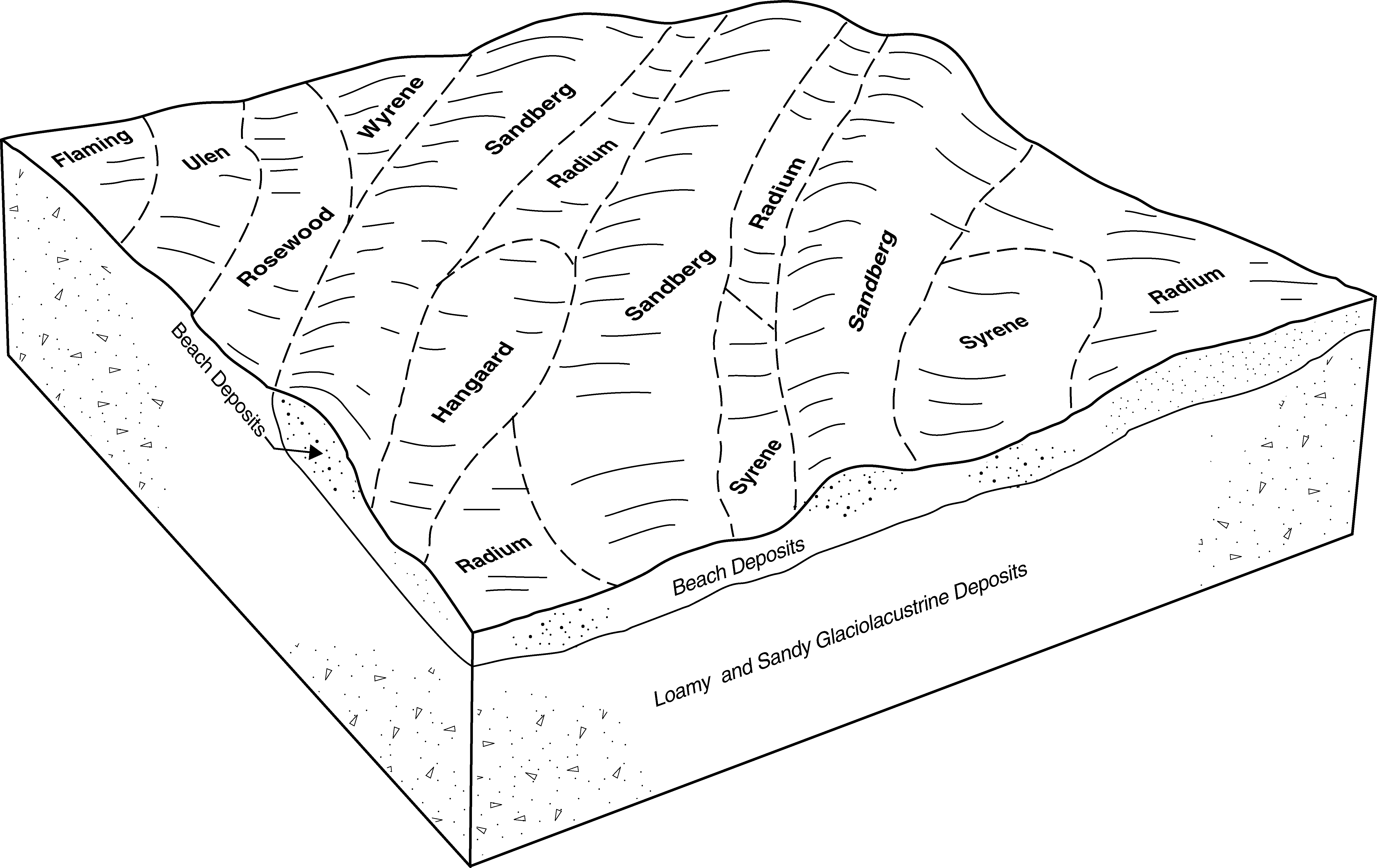
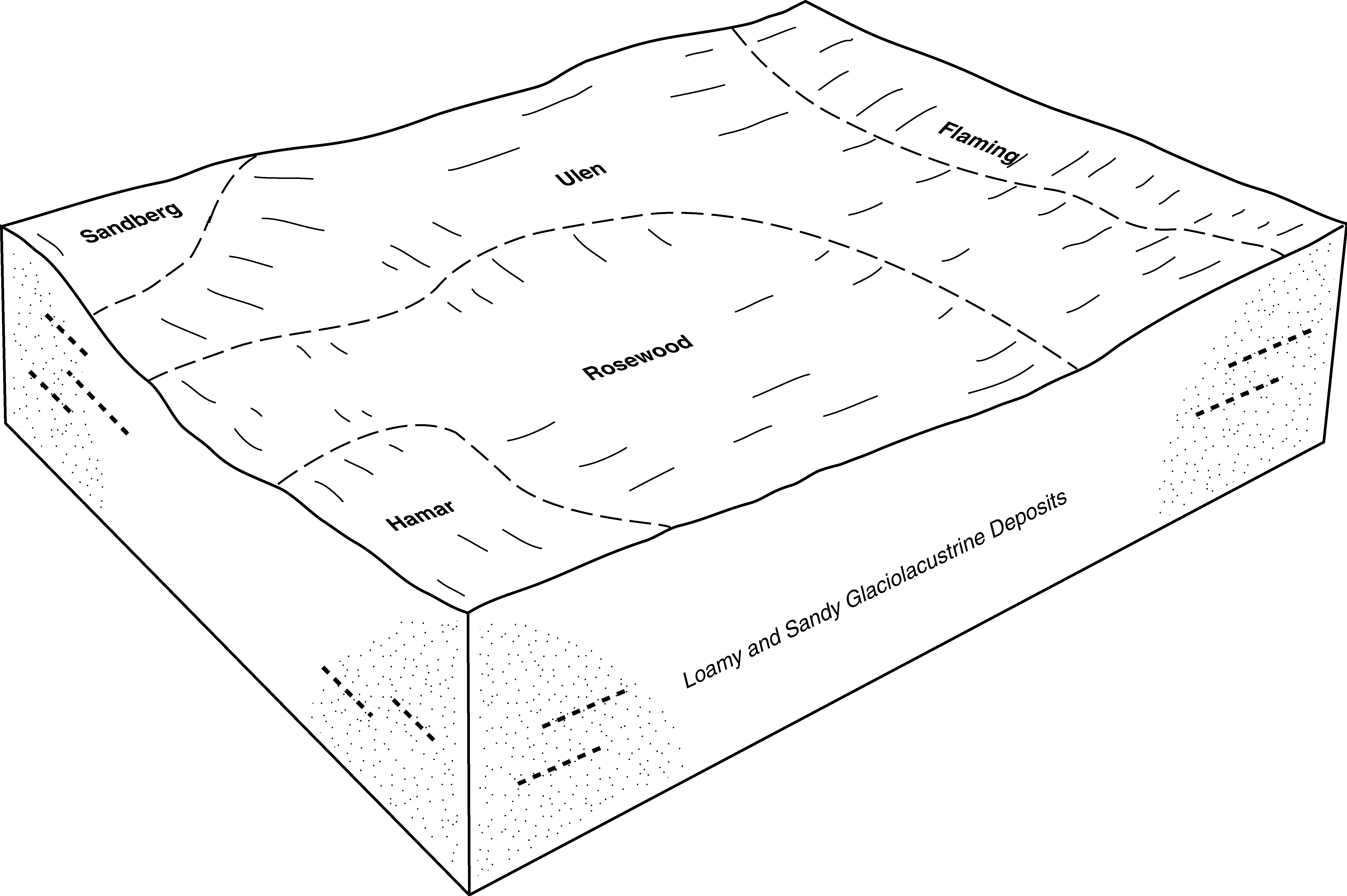
Rosewood-Ulen fine sandy loams, 0 to 2 percent slopes | I785A | 1270 | 2799900 | 2sw8v | mn135 | 1999 | 1:24000 |
Rosewood-Ulen complex, 0 to 2 percent slopes | 1181 | 1208 | 394789 | f7t4 | mn135 | 1999 | 1:24000 |
Ulen fine sandy loam, 0 to 3 percent slopes | 64 | 733 | 394899 | f7xp | mn135 | 1999 | 1:24000 |
Ulen fine sandy loam, 0 to 2 percent slopes | I356A | 7981 | 2799993 | 1nyxj | mn167 | 1985 | 1:20000 |
Ulen loamy fine sand, 0 to 2 percent slopes | F340A | 17422 | 2585868 | 2q542 | nd009 | 1981 | 1:20000 |
Ulen fine sandy loam, 0 to 2 percent slopes | F339A | 18 | 2586084 | 2q541 | nd009 | 1981 | 1:20000 |
Hecla-Ulen loamy fine sands, low precipitation, 0 to 6 percent slopes | C311B | 10 | 2595659 | 2q739 | nd015 | 1967 | 1:20000 |
Ulen fine sandy loam, 0 to 2 percent slopes | I356A | 7827 | 2640904 | 1nyxj | nd017 | 1983 | 1:20000 |
Hecla-Ulen fine sandy loams, 0 to 2 percent slopes | I514A | 1048 | 2640906 | 1tbnw | nd017 | 1983 | 1:20000 |
Garborg-Ulen fine sandy loams, 0 to 2 percent slopes | I354A | 137 | 2521599 | 1nyxg | nd017 | 1983 | 1:20000 |
Ulen-Rosewood fine sandy loams, 0 to 2 percent slopes | I357A | 88 | 2521611 | 1nyxk | nd017 | 1983 | 1:20000 |
Ulen fine sandy loam, 0 to 2 percent slopes | G339A | 8151 | 2575316 | 2q506 | nd021 | 1989 | 1:20000 |
Ulen-Hecla loamy fine sands, 0 to 2 percent slopes | G335A | 2423 | 2575314 | 2q503 | nd021 | 1989 | 1:20000 |
Ulen-Hamar fine sandy loams, 0 to 2 percent slopes | G350A | 534 | 2575318 | 2q50c | nd021 | 1989 | 1:20000 |
Ulen-Hecla fine sandy loams, 0 to 2 percent slopes | G334A | 1173 | 2576437 | 2q502 | nd031 | 1990 | 1:20000 |
Ulen fine sandy loam, 0 to 2 percent slopes | I356A | 10 | 2642549 | 1nyxj | nd035 | 1980 | 1:20000 |
Hecla-Ulen loamy fine sands, low precipitation, 0 to 6 percent slopes | C311B | 18472 | 2564428 | 2q739 | nd043 | 1985 | 1:20000 |
Arveson-Ulen complex, 0 to 2 percent slopes | C43A | 9522 | 2564419 | 2q1nr | nd043 | 1985 | 1:20000 |
Ulen fine sandy loam, 0 to 2 percent slopes | F339A | 47946 | 2585803 | 2q541 | nd049 | 1987 | 1:20000 |
Ulen-Hecla loamy fine sands, 0 to 2 percent slopes | F335A | 27639 | 2585656 | 2q540 | nd049 | 1987 | 1:20000 |
Ulen-Hecla loamy fine sands, 0 to 2 percent slopes | G335A | 3810 | 2571357 | 2q503 | nd049 | 1987 | 1:20000 |
Ulen fine sandy loam, 0 to 2 percent slopes | G339A | 1710 | 2571358 | 2q506 | nd049 | 1987 | 1:20000 |
Ulen loamy fine sand, 0 to 2 percent slopes | F340A | 167 | 2585564 | 2q542 | nd049 | 1987 | 1:20000 |
Ulen fine sandy loam, 0 to 2 percent slopes | I356A | 1 | 2642968 | 1nyxj | nd067 | 1972 | 1:20000 |
Ulen-Hecla loamy fine sands, 0 to 2 percent slopes | F335A | 6993 | 2587228 | 2q540 | nd069 | 1975 | 1:20000 |
Ulen-Hecla loamy fine sands, 0 to 2 percent slopes | G335A | 2410 | 2582300 | 2q503 | nd069 | 1975 | 1:20000 |
Ulen fine sandy loam, 0 to 2 percent slopes | F339A | 109 | 2506000 | 2q541 | nd069 | 1975 | 1:20000 |
Ulen loamy fine sand, 0 to 2 percent slopes | F340A | 21 | 2587166 | 2q542 | nd069 | 1975 | 1:20000 |
Ulen fine sandy loam, 0 to 2 percent slopes | I356A | 9483 | 2641293 | 1nyxj | nd073 | 1992 | 1:20000 |
Ulen-Rosewood fine sandy loams, 0 to 2 percent slopes | I357A | 6867 | 2641294 | 1nyxk | nd073 | 1992 | 1:20000 |
Ulen fine sandy loam, 0 to 2 percent slopes | G339A | 234 | 2581165 | 2q506 | nd073 | 1992 | 1:20000 |
Garborg-Ulen fine sandy loams, 0 to 2 percent slopes | I354A | 17 | 2641291 | 1nyxg | nd073 | 1992 | 1:20000 |
Ulen-Rosewood fine sandy loams, 0 to 2 percent slopes | I357A | 7630 | 2640996 | 1nyxk | nd077 | 2005 | 1:12000 |
Ulen fine sandy loam, 0 to 2 percent slopes | I356A | 7253 | 2641136 | 1nyxj | nd077 | 2005 | 1:12000 |
Ulen-Garborg-Aylmer complex, 0 to 2 percent slopes | I358A | 2402 | 2641108 | 1nyxl | nd077 | 2005 | 1:12000 |
Garborg-Ulen, slightly saline loamy fine sands, stratified substratum, 0 to 2 percent slopes | I296A | 2361 | 2641055 | 1nyvx | nd077 | 2005 | 1:12000 |
Ulen-Rosewood fine sandy loams, slightly saline, stratified substratum, 0 to 2 percent slopes | I300A | 2345 | 2641182 | 1nyw1 | nd077 | 2005 | 1:12000 |
Ulen fine sandy loam, slightly saline, stratified substratum, 0 to 2 percent slopes | I299A | 1881 | 2641009 | 1nyw0 | nd077 | 2005 | 1:12000 |
Garborg-Ulen loamy fine sands, 0 to 2 percent slopes | I353A | 1109 | 2641183 | 1nyxf | nd077 | 2005 | 1:12000 |
Garborg-Ulen fine sandy loams, 0 to 2 percent slopes | I354A | 815 | 2640979 | 1nyxg | nd077 | 2005 | 1:12000 |
Garborg-Ulen, slightly saline fine sandy loams, stratified substratum, 0 to 2 percent slopes | I297A | 326 | 2641165 | 1nyvy | nd077 | 2005 | 1:12000 |
Ulen-Hamar fine sandy loams, 0 to 2 percent slopes | F350A | 3520 | 2588213 | 2q544 | nd079 | 1990 | 1:24000 |
Ulen-Hecla loamy fine sands, 0 to 2 percent slopes | F335A | 10 | 2588086 | 2q540 | nd079 | 1990 | 1:24000 |
Ulen fine sandy loam, 0 to 2 percent slopes | G339A | 965 | 2579466 | 2q506 | nd081 | 1959 | 1:12000 |
Ulen-Hecla loamy fine sands, 0 to 2 percent slopes | G335A | 3347 | 2581369 | 2q503 | nd093 | 1990 | 1:24000 |
Hecla-Ulen loamy fine sands, low precipitation, 0 to 6 percent slopes | C311B | 194 | 2566874 | 2q739 | nd093 | 1990 | 1:24000 |
Ulen fine sandy loam, 0 to 2 percent slopes | I356A | 607 | 2641606 | 1nyxj | nd097 | 1974 | 1:20000 |
Hecla-Ulen fine sandy loams, 0 to 2 percent slopes | I514A | 592 | 2642448 | 1tbnw | nd097 | 1974 | 1:20000 |
Ulen fine sandy loam, 0 to 2 percent slopes | I356A | 4091 | 2642843 | 1nyxj | nd099 | 1967 | 1:20000 |
Garborg-Ulen loamy sands, 0 to 2 percent slopes | I438A | 582 | 2642924 | 2ncw9 | nd099 | 1967 | 1:20000 |
Garborg-Ulen fine sandy loams, 0 to 2 percent slopes | I354A | 469 | 2642842 | 1nyxg | nd099 | 1967 | 1:20000 |
Ulen-Garborg fine sandy loams, 0 to 2 percent slopes | G338A | 1547 | 2579649 | 2q505 | nd103 | 1966 | 1:12000 |
Ulen fine sandy loam, 0 to 2 percent slopes | G339A | 10834 | 2797666 | 2q506 | sd013 | 1987 | 1:20000 |
Ulen-Stirum fine sandy loams, 0 to 2 percent slopes | G348A | 3892 | 2797756 | 2sd2n | sd013 | 1987 | 1:20000 |
Stirum-Ulen fine sandy loams, 0 to 2 percent slopes | G349A | 98 | 2797757 | 2sd2p | sd013 | 1987 | 1:20000 |
Ulen fine sandy loam, 0 to 2 percent slopes | G339A | 8798 | 2799286 | 2q506 | sd091 | 1970 | 1:20000 |
Ulen-Stirum fine sandy loams, 0 to 2 percent slopes | G348A | 4219 | 2799335 | 2sd2n | sd091 | 1970 | 1:20000 |
Stirum-Ulen fine sandy loams, 0 to 2 percent slopes | G349A | 1917 | 2799336 | 2sd2p | sd091 | 1970 | 1:20000 |
Ulen sandy loam | Un | 367 | 417880 | g0v0 | sd109 | 1977 | 1:20000 |
Ulen fine sandy loam, 0 to 2 percent slopes | I356A | 359 | 2800175 | 1nyxj | sd109 | 1977 | 1:20000 |

