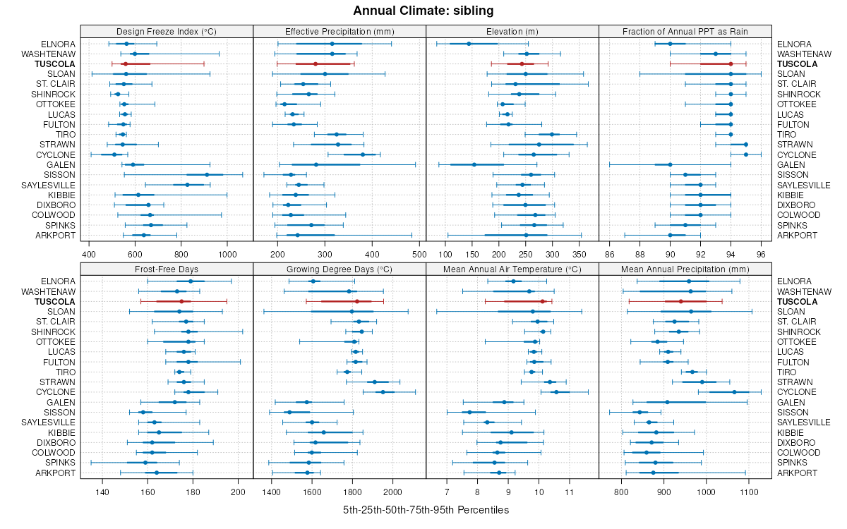
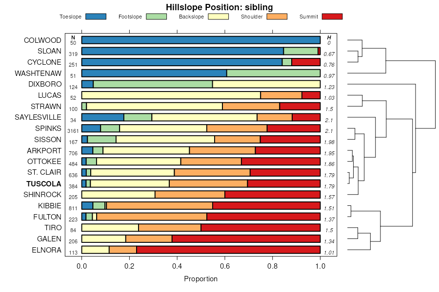
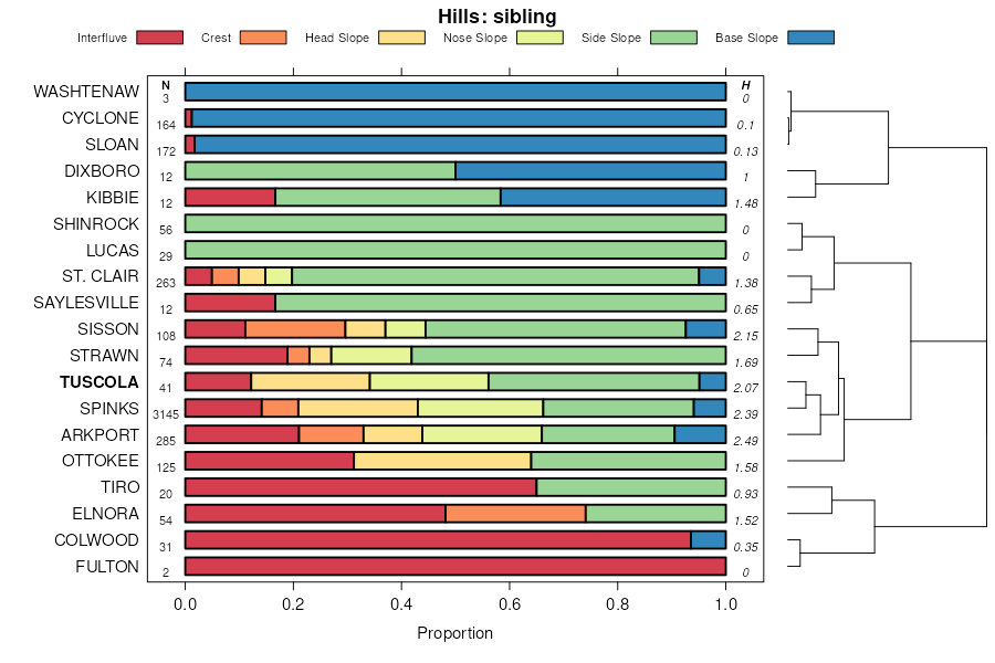
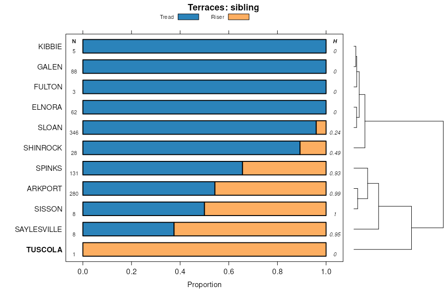
Official Series Description


Lab Data Summary

Aggregate lab data for the TUSCOLA soil series. This aggregation is based on all pedons with a current taxon name of TUSCOLA, and applied along 1-cm thick depth slices. Solid lines are the slice-wise median, bounded on either side by the interval defined by the slice-wise 5th and 95th percentiles. The median is the value that splits the data in half. Five percent of the data are less than the 5th percentile, and five percent of the data are greater than the 95th percentile. Values along the right hand side y-axis describe the proportion of pedon data that contribute to aggregate values at this depth. For example, a value of "90%" at 25cm means that 90% of the pedons correlated to TUSCOLA were used in the calculation. Source: KSSL snapshot . Methods used to assemble the KSSL snapshot used by SoilWeb / SDE

Click the image to view it full size.

Pedons used in the lab summary:

MLRALab IDPedon IDTaxonnameCINSSL / NASIS ReportsLink To SoilWeb GMap
111A06N0667S2005IN159001Tuscola6Primary | Supplementary | Taxonomy | Pedon | Water Retention | Correlation | Andic Soil Properties40.3788605,-85.9560547
111BWY-0241978-OH175-024Tuscola5Primary | Supplementary | Taxonomy | Pedon | Water Retention | Correlation | Andic Soil Properties40.8598061,-83.2291489
111BWE85111985IN179011Tuscola2Primary | Supplementary | Taxonomy | Pedon | Water Retention | Correlation | Andic Soil Properties40.7541667,-85.1715778
99AL-0041954-OH003-004Tuscola2Primary | Supplementary | Taxonomy | Pedon | Water Retention | Correlation | Andic Soil Properties40.8581505,-84.243515
99WD-0581955-OH173-058Tuscola2Primary | Supplementary | Taxonomy | Pedon | Water Retention | Correlation | Andic Soil Properties41.3607216,-83.5939713
99SA-0071959-OH147-007Tuscola2Primary | Supplementary | Taxonomy | Pedon | Water Retention | Correlation | Andic Soil Properties41.197464,-83.0637665
99WL-0251970-OH171-025Tuscola3Primary | Supplementary | Taxonomy | Pedon | Water Retention | Correlation | Andic Soil Properties41.5667229,-84.4142838
99HN-S011975-OH069-S01Tuscola2Primary | Supplementary | Taxonomy | Pedon | Water Retention | Correlation | Andic Soil Properties41.4359169,-84.0790558
n/aER-0071954-OH043-007Tuscola1Primary | Supplementary | Taxonomy | Pedon | Water Retention | Correlation | Andic Soil Propertiesn/a
n/aER-0131959-OH043-013Tuscola2Primary | Supplementary | Taxonomy | Pedon | Water Retention | Correlation | Andic Soil Propertiesn/a

Water Balance

Monthly water balance estimated using a leaky-bucket style model for the TUSCOLA soil series. Monthly precipitation (PPT) and potential evapotranspiration (PET) have been estimated from the 50th percentile of gridded values (PRISM 1981-2010) overlapping with the extent of SSURGO map units containing each series as a major component. Monthly PET values were estimated using the method of Thornthwaite (1948). These (and other) climatic parameters are calculated with each SSURGO refresh and provided by the fetchOSD function of the soilDB package. Representative water storage values (“AWC” in the figures) were derived from SSURGO by taking the 50th percentile of profile-total water storage (sum[awc_r * horizon thickness]) for each soil series. Note that this representation of “water storage” is based on the average ability of most plants to extract soil water between 15 bar (“permanent wilting point”) and 1/3 bar (“field capacity”) matric potential. Soil moisture state can be roughly interpreted as “dry” when storage is depleted, “moist” when storage is between 0mm and AWC, and “wet” when there is a surplus. Clearly there are a lot of assumptions baked into this kind of monthly water balance. This is still a work in progress.

Click the image to view it full size.


Click the image to view it full size.

Sibling Summary

Siblings are those soil series that occur together in map units, in this case with the TUSCOLA series. Sketches are arranged according to their subgroup-level taxonomic structure. Source: SSURGO snapshot , parsed OSD records and snapshot of SC database .

Click the image to view it full size.

Select annual climate data summaries for the TUSCOLA series and siblings. Series are sorted according to hierarchical clustering of median values. Source: SSURGO map unit geometry and 1981-2010, 800m PRISM data .

Click the image to view it full size.

Geomorphic description summaries for the TUSCOLA series and siblings. Series are sorted according to hierarchical clustering of proportions and relative hydrologic position within an idealized landform (e.g. top to bottom). Most soil series (SSURGO components) are associated with a hillslope position and one or more landform-specific positions: hills, mountain slopes, terraces, and/or flats. Proportions can be interpreted as an aggregate representation of geomorphic membership. The values printed to the left (number of component records) and right (Shannon entropy) of stacked bars can be used to judge the reliability of trends. Small Shannon entropy values suggest relatively consistent geomorphic association, while larger values suggest lack thereof. Source: SSURGO component records .

Click the image to view it full size.

Click the image to view it full size.

There are insufficient data to create the 3D mountains figure.

Click the image to view it full size.

Click the image to view it full size.

Competing Series

Soil series competing with TUSCOLA share the same family level classification in Soil Taxonomy. Source: parsed OSD records and snapshot of the SC database .

Click the image to view it full size.

Select annual climate data summaries for the TUSCOLA series and competing. Series are sorted according to hierarchical clustering of median values. Source: SSURGO map unit geometry and 1981-2010, 800m PRISM data .

Click the image to view it full size.

Geomorphic description summaries for the TUSCOLA series and competing. Series are sorted according to hierarchical clustering of proportions and relative hydrologic position within an idealized landform (e.g. top to bottom). Proportions can be interpreted as an aggregate representation of geomorphic membership. Most soil series (SSURGO components) are associated with a hillslope position and one or more landform-specific positions: hills, mountain slopes, terraces, and/or flats. The values printed to the left (number of component records) and right (Shannon entropy) of stacked bars can be used to judge the reliability of trends. Shannon entropy values close to 0 represent soil series with relatively consistent geomorphic association, while values close to 1 suggest lack thereof. Source: SSURGO component records .

Click the image to view it full size.

Click the image to view it full size.

Click the image to view it full size.

Click the image to view it full size.

Click the image to view it full size.

Soil series sharing subgroup-level classification with TUSCOLA, arranged according to family differentiae. Hovering over a series name will print full classification and a small sketch from the OSD. Source: snapshot of SC database .

Block Diagrams

Click a link below to display the diagram. Note that these diagrams may be from multiple survey areas.

  1. IN-2012-01-20-07 | Tipton County - April 1989

    Pattern of soils and parent material in the Patton-Del Rey-Crosby map unit (Soil Survey of Tipton County, Indiana; 1989).

  2. OH-2012-02-16-30 | Henry County - November 1974

    Relationship of soils to underlying, or parent, material and relief in the northeastern part of the county (Soil Survey of Henry County, Ohio; November 1974).

  3. OH-2012-02-16-33 | Huron County - June 1994

    Typical pattern of soils and parent material in the Kibbie-Tuscola association (Soil Survey of Huron County, Ohio; June 1994).

Map Units

Map units containing TUSCOLA as a major component. Limited to 250 records.

Map Unit Name Symbol Map Unit Area (ac) Map Unit Key National Map Unit Symbol Soil Survey Area Publication Date Map Scale
Tuscola loam, 2 to 5 percent slopes573B28861769915y5dil10519911:15840
Tuscola loam, 5 to 10 percent slopes, eroded573C24611769925y5fil10519911:15840
Tuscola, till substratum-Strawn complex, 1 to 6 percent slopes, erodedTuB2432913355fr2in06719671:20000
Tuscola, till substratum-Strawn complex, 1 to 6 percent slopes, erodedTuB21932913485fr2in09519651:15840
Tuscola, till substratum-Strawn complex, 1 to 6 percent slopes, erodedTuB264761621635fr2in15919851:15840
Tuscola silt loam, till substratum, 2 to 6 percent slopes, erodedTwB210671631755gsqin17119871:15840
Tuscola loam, till substratum, 6 to 12 percent slopes, erodedTuC22501631745gspin17119871:15840
Tuscola loam, loamy substratum, 1 to 6 percent slopes, erodedTuB26001612795dtkin17919881:15840
Tuscola loamy, substratum-Urban land complex, 1 to 6 percent slopes, erodedYtuB23832168762yc5hin17919881:15840
Tuscola loam, 2 to 6 percent slopesTsB224379132mtvcmi03719741:15840
Tuscola fine sandy loam, 0 to 4 percent slopesTuA165918625667t8mi04519741:15840
Tuscola silt loam, 2 to 6 percent slopesTsB116918690568h6mi04919671:20000
Tuscola silt loam, 0 to 2 percent slopesTsA39618690468h5mi04919671:20000
Tuscola soils, 2 to 6 percent slopesTsB32218820269v1mi06719651:15840
Tuscola soils, 2 to 6 percent slopes, moderately erodedTsB224918820369v2mi06719651:15840
Tuscola soils, 6 to 12 percent slopes, moderately erodedTsC212318820469v3mi06719651:15840
Tuscola soils, 0 to 2 percent slopesTsA9518820169v0mi06719651:15840
Tuscola loamy fine sand, 2 to 6 percent slopesTuB7518820569v4mi06719651:15840
Tuscola silt loam, 2 to 6 percent slopes54B78418716868rpmi08119841:15840
Tuscola silt loam, 6 to 12 percent slopes54C62218716968rqmi08119841:15840
Tuscola very fine sandy loam, 2 to 6 percent slopesTuB11231921636fytmi08719661:15840
Tuscola very fine sandy loam, 0 to 2 percent slopesTuA3761921626fysmi08719661:15840
Tuscola loam, 2 to 6 percent slopesTsB324395572mwkdmi09319681:20000
Tuscola silt loam, 0 to 6 percent slopes93B3031926176gfgmi10519921:15840
Tuscola silt loam, 2 to 6 percent slopes118B724382642mv6pmi12519801:15840
Tuscola fine sandy loam, 2 to 6 percent slopesTsB2621927426gkhmi13919671:15840
Tuscola loam, 2 to 6 percent slopes125B724224922m9sxmi14519911:15840
Tuscola loam, 2 to 6 percent slopesTsB121218785669gwmi15519671:12000
Tuscola very fine sandy loam, 2 to 6 percent slopes140B225081406fytmi15719841:15840
Tuscola silt loam, 0 to 4 percent slopes33B464718631567w5mi15919841:15840
Tuscola fine sandy loam, 2 to 6 percent slopesTsB6571685955nfkoh03319751:15840
Tuscola-Bennington complex, 2 to 6 percent slopesTuB6101685965nfloh03319751:15840
Tuscola very fine sandy loam, 2 to 6 percent slopesTsB5631684805n9voh03919811:15840
Tuscola loam, 6 to 12 percent slopes, moderately erodedTtC2115398001np8zoh03919811:15840
Tuscola fine sandy loam, 0 to 2 percent slopesTuA25891721935s5moh04319981:12000
Tuscola fine sandy loam, 2 to 6 percent slopesTuB18101721945s5noh04319981:12000
Tuscola fine sandy loam, 3 to 8 percent slopesTuB13191691205nzhoh05119811:15840
Shinrock-Tuscola complex, 3 to 8 percent slopes, erodedSgB28811691135nz8oh05119811:15840
Tuscola fine sandy loam, 0 to 2 percent slopesTpA637644463pmm4oh06319971:12000
Tuscola loamy fine sand, 2 to 6 percent slopesToB306644462pmm3oh06319971:12000
Tuscola fine sandy loam, 2 to 6 percent slopesTpB303644464pmm5oh06319971:12000
Tuscola silt loam, 2 to 6 percent slopesTuB154644465pmm6oh06319971:12000
Tuscola loam, 6 to 12 percent slopes, moderately erodedTuC21831690595nxjoh06919681:15840
Tuscola loam, 2 to 6 percent slopes, moderately erodedTuB21531690585nxhoh06919681:15840
Tuscola fine sandy loam, 0 to 2 percent slopesTuA30671680035mtgoh07719881:15840
Tuscola fine sandy loam, 2 to 6 percent slopesTuB26791680045mthoh07719881:15840
Tuscola fine sandy loam, 3 to 8 percent slopesTuB191698875ps7oh09519781:15840
Tuscola-Shinrock complex, 2 to 6 percent slopesTwB11431706975qmcoh13719711:20000
Tuscola loam, 2 to 6 percent slopesTuB1161706965qmboh13719711:20000
Ottokee-Tuscola complex, 2 to 6 percent slopesOtB1111706685qlfoh13719711:20000
Tuscola loamy fine sand, 2 to 6 percent slopesTvB2115291691nb71oh13719711:20000
Tuscola fine sandy loam, 0 to 2 percent slopesTxA1715291701nb72oh13719711:20000
Tuscola very fine sandy loam, 2 to 6 percent slopesTtB2114140451jgfcoh17119751:15840
Tuscola fine sandy loam, 3 to 8 percent slopesTrB1714141321jgj5oh17119751:15840
Shinrock-Tuscola complex, 3 to 8 percent slopes, erodedSfB2114141301jgj3oh17119751:15840
Tuscola fine sandy loam, 2 to 6 percent slopesTuB23111696695pk6oh17519801:15840
Tuscola silt loam, 2 to 6 percent slopesTuB2255423836g714wi05519761:15840
Tuscola silt loam, 0 to 2 percent slopesTuA646423835g713wi05519761:15840

Map of Series Extent

Approximate geographic distribution of the TUSCOLA soil series. To learn more about how this distribution was mapped, or to compare this soil series extent to others, use the Series Extent Explorer (SEE) application. Source: generalization of SSURGO geometry .