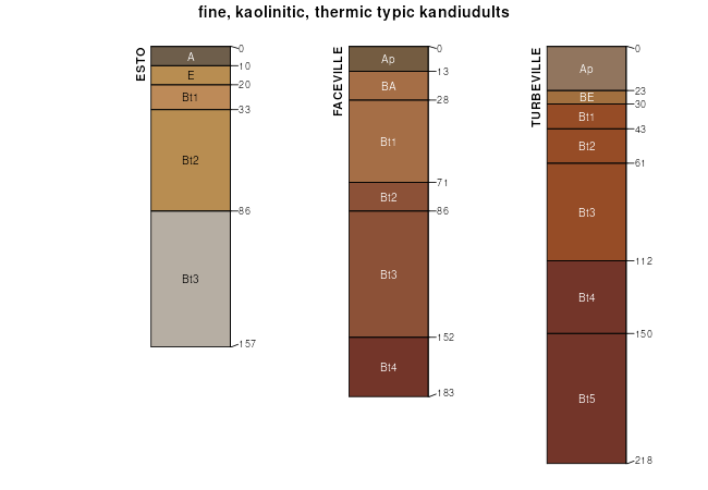
| Turbeville fine sandy loam, 0 to 3 percent slopes | TuA | 226 | 1485695 | 1lvzn | nc037 | 2005 | 1:24000 |
Turbeville fine sandy loam, 2 to 6 percent slopes | TuB | 497 | 113067 | 3snb | nc083 | 1995 | 1:24000 |
Turbeville sandy loam, 2 to 8 percent slopes | TuB | 99 | 2233626 | 2dz8g | nc123 | 2007 | 1:24000 |
Turbeville sandy loam, 2 to 6 percent slopes | TsB | 2815 | 114069 | 3tpn | nc131 | 1988 | 1:24000 |
Lillington-Turbeville complex, 8 to 15 percent slopes | LtD | 1735 | 114048 | 3tnz | nc131 | 1988 | 1:24000 |
Turbeville gravelly sandy loam, 2 to 8 percent slopes | TuB | 1262 | 114072 | 3tpr | nc131 | 1988 | 1:24000 |
Turbeville sandy loam, 0 to 2 percent slopes | TsA | 1215 | 114068 | 3tpm | nc131 | 1988 | 1:24000 |
Turbeville sandy clay loam, 2 to 6 percent slopes, moderately eroded | TtB2 | 1097 | 114071 | 3tpq | nc131 | 1988 | 1:24000 |
Turbeville loamy sand, 0 to 2 percent slopes | TrA | 1031 | 114066 | 3tpk | nc131 | 1988 | 1:24000 |
Turbeville loamy sand, 2 to 6 percent slopes | TrB | 871 | 114067 | 3tpl | nc131 | 1988 | 1:24000 |
Turbeville-Urban land complex, 0 to 8 percent slopes | TxB | 376 | 114073 | 3tps | nc131 | 1988 | 1:24000 |
Turbeville sandy loam, 6 to 12 percent slopes | TsC | 244 | 114070 | 3tpp | nc131 | 1988 | 1:24000 |
Turbeville sandy loam, 2 to 8 percent slopes | TbB | 5055 | 114742 | 3vdc | nc153 | 1996 | 1:24000 |
Turbeville sandy loam, 0 to 2 percent slopes | TbA | 788 | 114741 | 3vdb | nc153 | 1996 | 1:24000 |
Turbeville fine sandy loam, 2 to 8 percent slopes | TuB | 323 | 2455026 | 2ndnd | nc185 | 2009 | 1:24000 |
Turbeville fine sandy loam, 15 to 30 percent slopes | TuE | 74 | 2455028 | 2ndng | nc185 | 2009 | 1:24000 |
Turbeville fine sandy loam, 8 to 15 percent slopes | TuC | 14 | 2455027 | 2ndnf | nc185 | 2009 | 1:24000 |
Turbeville sandy clay loam, 2 to 6 percent slopes, moderately eroded | TuB2 | 277 | 2513868 | 2lq3d | sc091 | 2013 | 1:15840 |
Turbeville sandy clay loam, 6 to 10 percent slopes, moderately eroded | TuC2 | 142 | 2513869 | 2lq3f | sc091 | 2013 | 1:15840 |
Turbeville-Tatum complex, 7 to 15 percent slopes | 25C | 686 | 118298 | 3z32 | va011 | 1993 | 1:15840 |
Turbeville-Tatum complex, 15 to 25 percent slopes | 25D | 551 | 118299 | 3z33 | va011 | 1993 | 1:15840 |
Turbeville-Tatum complex, 2 to 7 percent slopes | 25B | 517 | 118297 | 3z31 | va011 | 1993 | 1:15840 |
Turbeville loam, 2 to 7 percent slopes | 24B | 335 | 118294 | 3z2y | va011 | 1993 | 1:15840 |
Turbeville loam, 7 to 15 percent slopes | 24C | 291 | 118295 | 3z2z | va011 | 1993 | 1:15840 |
Turbeville sandy loam, 2 to 8 percent slopes | 28B | 308 | 2420761 | 2m802 | va025 | 2007 | 1:24000 |
Turbeville loam, 2 to 6 percent slopes | 45B | 563 | 117913 | 3ypn | va036 | 1993 | 1:24000 |
Turbeville fine sandy loam, 2 to 6 percent slopes, eroded | TuB2 | 1505 | 118782 | 3zlp | va037 | 1970 | 1:15840 |
Turbeville fine sandy loam, 6 to 15 percent slopes, eroded | TuD2 | 1101 | 118783 | 3zlq | va037 | 1970 | 1:15840 |
Turbeville clay loam, 6 to 15 percent slopes, severely eroded | TvD3 | 754 | 118786 | 3zlt | va037 | 1970 | 1:15840 |
Turbeville fine sandy loam, 15 to 35 percent slopes, eroded | TuF2 | 677 | 118784 | 3zlr | va037 | 1970 | 1:15840 |
Turbeville clay loam, 2 to 6 percent slopes, severely eroded | TvB3 | 258 | 118785 | 3zls | va037 | 1970 | 1:15840 |
Turbeville fine sandy loam, 2 to 6 percent slopes | 107B | 913 | 118815 | 3zmr | va041 | 1974 | 1:15840 |
Turbeville gravelly fine sandy loam, 2 to 6 percent slopes | 108B | 360 | 118817 | 3zmt | va041 | 1974 | 1:15840 |
Turbeville fine sandy loam, 6 to 12 percent slopes | 107C | 266 | 118816 | 3zms | va041 | 1974 | 1:15840 |
Turbeville gravelly fine sandy loam, 6 to 12 percent slopes | 108C | 103 | 118818 | 3zmv | va041 | 1974 | 1:15840 |
Turbeville fine sandy loam, 2 to 7 percent slopes, eroded | 38B2 | 2453 | 119035 | 3zvv | va075 | 1976 | 1:15840 |
Turbeville fine sandy loam, 7 to 15 percent slopes, eroded | 38C2 | 478 | 119036 | 3zvw | va075 | 1976 | 1:15840 |
Turbeville sandy clay loam, 7 to 15 percent slopes, severely eroded | 39C3 | 300 | 119038 | 3zvy | va075 | 1976 | 1:15840 |
Turbeville sandy clay loam, 2 to 7 percent slopes, severely eroded | 39B3 | 151 | 119037 | 3zvx | va075 | 1976 | 1:15840 |
Turbeville fine sandy loam, 2 to 8 percent slopes | 50B | 308 | 1472861 | 1lfmn | va083 | 2004 | 1:24000 |
Turbeville fine sandy loam, 8 to 15 percent slopes | 50C | 25 | 1472862 | 1lfmp | va083 | 2004 | 1:24000 |
Turbeville fine sandy loam, 2 to 7 percent slopes | 65B | 190 | 119159 | 3zzv | va085 | 1976 | 1:15840 |
Turbeville fine sandy loam, 2 to 6 percent slopes | TuB | 1176 | 119290 | 4042 | va087 | 1973 | 1:15840 |
Turbeville fine sandy loam, 6 to 10 percent slopes, eroded | TuC2 | 340 | 119291 | 4043 | va087 | 1973 | 1:15840 |
Turbeville fine sandy loam, 0 to 2 percent slopes | TuA | 211 | 119289 | 4041 | va087 | 1973 | 1:15840 |
Cecil and Turbeville clay loams, 6 to 25 percent slopes, severely eroded | CfD3 | 195 | 119216 | 401p | va087 | 1973 | 1:15840 |
Turbeville gravelly fine sandy loam, 2 to 6 percent slopes | TvB | 118 | 119292 | 4044 | va087 | 1973 | 1:15840 |
Turbeville gravelly fine sandy loam, 6 to 10 percent slopes | TvC | 102 | 119293 | 4045 | va087 | 1973 | 1:15840 |
Turbeville fine sandy loam, 2 to 12 percent slopes | TuB | 379 | 119427 | 408h | va109 | 1972 | 1:15840 |
Turbeville fine sandy loam, 2 to 7 percent slopes | 22B | 280 | 119464 | 409p | va111 | 1979 | 1:20000 |
Turbeville fine sandy loam, 2 to 7 percent slopes, eroded | 24B2 | 9000 | 120201 | 412g | va145 | 1984 | 1:15840 |
Turbeville gravelly fine sandy loam, 7 to 15 percent slopes | 25C | 2400 | 120202 | 412h | va145 | 1984 | 1:15840 |
Turbeville fine sandy loam, 0 to 2 percent slopes | 24A | 987 | 120200 | 412f | va145 | 1984 | 1:15840 |
Turbeville gravelly fine sandy loam, 15 to 25 percent slopes | 25D | 951 | 120203 | 412j | va145 | 1984 | 1:15840 |
Turbeville loam, 7 to 15 percent slopes, eroded | 43C2 | 268 | 120445 | 41bb | va177 | 1980 | 1:15840 |
Turbeville loam, 2 to 7 percent slopes | 43B | 173 | 120444 | 41b9 | va177 | 1980 | 1:15840 |
Turbeville loam, 2 to 6 percent slopes | TuB | 3262 | 120570 | 41gc | va179 | 1970 | 1:15840 |
Turbeville loam, 6 to 15 percent slopes, eroded | TuC2 | 1585 | 120571 | 41gd | va179 | 1970 | 1:15840 |
Turbeville loam, 0 to 2 percent slopes | TuA | 400 | 120569 | 41gb | va179 | 1970 | 1:15840 |
Turbeville loam, 2 to 6 percent slopes | 23B | 1217 | 120612 | 41hq | va193 | 1980 | 1:20000 |
Turbeville loam, 6 to 10 percent slopes | 23C | 313 | 120613 | 41hr | va193 | 1980 | 1:20000 |
Turbeville loam, 0 to 2 percent slopes | 23A | 211 | 120611 | 41hp | va193 | 1980 | 1:20000 |
Turbeville fine sandy loam, 6 to 15 percent slopes, eroded | TuC2 | 2789 | 120771 | 41nv | va631 | 1973 | 1:15840 |
Turbeville fine sandy loam, 2 to 6 percent slopes | TuB | 2711 | 120770 | 41nt | va631 | 1973 | 1:15840 |
Turbeville-Urban land complex, 2 to 6 percent slopes | 37B | 7385 | 140117 | 4psx | va760 | 2004 | 1:24000 |
Turbeville-Urban land complex, gravelly phase, 6 to 12 percent slopes | 38C | 62 | 140120 | 4pt0 | va760 | 2004 | 1:24000 |
Turbeville-Urban land complex, 6 to 12 percent slopes | 37C | 30 | 140118 | 4psy | va760 | 2004 | 1:24000 |
Turbeville-Urban land complex, gravelly phase, 2 to 6 percent slopes | 38B | 22 | 140119 | 4psz | va760 | 2004 | 1:24000 |