| Tunkhannock fine sandy loam, 25 to 60 percent slopes | TunkE | 58 | 812754 | w8qw | nj013 | 2003 | 1:12000 |
Tunkhannock fine sandy loam, 3 to 8 percent slopes | TunkB | 54 | 812750 | w8qr | nj013 | 2003 | 1:12000 |
Tunkhannock - Udorthents, Tunkhannock substratum complex, 0 to 8 percent slopes | TunudB | 38 | 812749 | w8qq | nj013 | 2003 | 1:12000 |
Tunkhannock fine sandy loam, 15 to 25 percent slopes | TunkD | 37 | 812752 | w8qt | nj013 | 2003 | 1:12000 |
Tunkhannock fine sandy loam, 8 to 15 percent slopes | TunkC | 31 | 812751 | w8qs | nj013 | 2003 | 1:12000 |
Tunkhannock - Udorthents complex, 0 to 8 percent slopes | TunudB | 726 | 1444927 | 1khkk | nj039 | 1989 | 1:24000 |
Tunkhannock gravelly loam, 25 to 45 percent slopes | TunE | 198 | 298724 | b0v8 | nj039 | 1989 | 1:24000 |
Tunkhannock gravelly loam, 8 to 15 percent slopes | TkC | 4055 | 290558 | 9rbv | ny025 | 1999 | 1:24000 |
Tunkhannock gravelly loam, 3 to 8 percent slopes | TkB | 4029 | 290557 | 9rbt | ny025 | 1999 | 1:24000 |
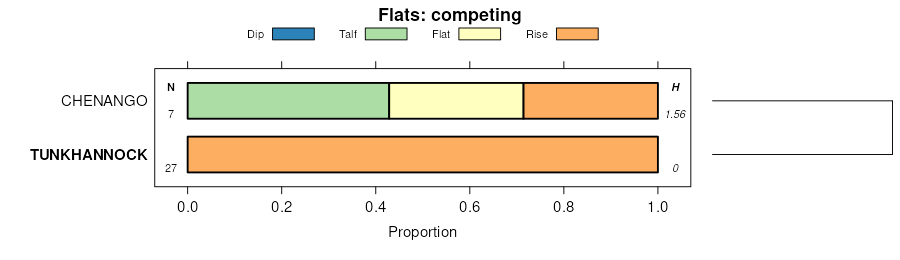
Tunkhannock and Chenango soils, fan, 3 to 8 percent slopes | TtB | 3435 | 290562 | 9rbz | ny025 | 1999 | 1:24000 |
Tunkhannock and Chenango soils, fan, 0 to 3 percent slopes | TtA | 2583 | 290561 | 9rby | ny025 | 1999 | 1:24000 |
Tunkhannock gravelly loam, 15 to 25 percent slopes | TkD | 1695 | 290559 | 9rbw | ny025 | 1999 | 1:24000 |
Tunkhannock gravelly loam, 25 to 50 percent slopes | TkE | 1539 | 290560 | 9rbx | ny025 | 1999 | 1:24000 |
Tunkhannock gravelly loam, 0 to 3 percent slopes | TkA | 1122 | 290556 | 9rbs | ny025 | 1999 | 1:24000 |
Tunkhannock gravelly loam, fan, 3 to 8 percent slopes | TvB | 3322 | 291722 | 9skd | ny039 | 1985 | 1:24000 |
Tunkhannock gravelly loam, 3 to 8 percent slopes | TuB | 2025 | 291719 | 9sk9 | ny039 | 1985 | 1:24000 |
Tunkhannock gravelly loam, rolling | TuC | 1485 | 291720 | 9skb | ny039 | 1985 | 1:24000 |
Tunkhannock and Chenango gravelly loams, 25 to 50 percent slopes | TwE | 849 | 291723 | 9skf | ny039 | 1985 | 1:24000 |
Tunkhannock gravelly loam, 0 to 3 percent slopes | TuA | 475 | 291718 | 9sk8 | ny039 | 1985 | 1:24000 |
Tunkhannock gravelly loam, hilly | TuD | 434 | 291721 | 9skc | ny039 | 1985 | 1:24000 |
Chenango, Howard, and Tunkhannock soils, 25 to 50 percent slopes | ClE | 3253 | 294193 | 9w43 | ny077 | 1993 | 1:24000 |
Tunkhannock gravelly loam, 3 to 8 percent slopes | TpB | 981 | 294292 | 9w79 | ny077 | 1993 | 1:24000 |
Tunkhannock gravelly loam, 8 to 15 percent slopes | TpC | 352 | 294293 | 9w7b | ny077 | 1993 | 1:24000 |
Tunkhannock and Chenango soils, 25 to 60 percent slopes | TnF | 1771 | 294561 | 9whz | ny095 | 1965 | 1:15840 |
Tunkhannock and Chenango gravelly silt loams, 15 to 25 percent slopes | ThD | 1339 | 294558 | 9whw | ny095 | 1965 | 1:15840 |
Tunkhannock and Chenango gravelly silt loams, 5 to 15 percent simple slopes | ThC | 840 | 294556 | 9wht | ny095 | 1965 | 1:15840 |
Tunkhannock and Chenango gravelly silt loams, 3 to 15 percent complex slopes | ThCK | 802 | 294557 | 9whv | ny095 | 1965 | 1:15840 |
Tunkhannock and Chenango gravelly silt loams, 0 to 5 percent simple slopes | ThA | 713 | 294555 | 9whs | ny095 | 1965 | 1:15840 |
Tunkhannock and Chenango gravelly loams, fans, 0 to 5 percent slopes | TcA | 689 | 294553 | 9whq | ny095 | 1965 | 1:15840 |
Tunkhannock and Chenango gravelly loams, fans, 5 to 15 percent slopes | TcC | 607 | 294554 | 9whr | ny095 | 1965 | 1:15840 |
Tunkhannock and Chenango soils, non-stratified 3 to 15 percent slopes | TkC | 515 | 294559 | 9whx | ny095 | 1965 | 1:15840 |
Tunkhannock and Chenango soils, non-stratified, 15 to 35 percent slopes | TkD | 251 | 294560 | 9why | ny095 | 1965 | 1:15840 |
Tunkhannock cobbly sandy loam, 0 to 5 slopes | TuA | 162 | 294562 | 9wj0 | ny095 | 1965 | 1:15840 |
Tunkhannock gravelly loam, 3 to 8 percent slopes | TkB | 2722 | 295138 | 9x3l | ny105 | 1984 | 1:15840 |
Tunkhannock gravelly loam, 0 to 3 percent slopes | TkA | 1363 | 295137 | 9x3k | ny105 | 1984 | 1:15840 |
Tunkhannock gravelly loam, 8 to 15 percent slopes | TkC | 1296 | 295139 | 9x3m | ny105 | 1984 | 1:15840 |
Tunkhannock and Otisville soils, steep | ToE | 1084 | 295141 | 9x3p | ny105 | 1984 | 1:15840 |
Tunkhannock and Otisville soils, very steep | ToF | 995 | 295142 | 9x3q | ny105 | 1984 | 1:15840 |
Tunkhannock gravelly loam, 15 to 25 percent slopes | TkD | 584 | 295140 | 9x3n | ny105 | 1984 | 1:15840 |
Tunkhannock gravelly loam, 3 to 8 percent slopes | TkB | 1939 | 295551 | 9xjx | ny111 | 1974 | 1:15840 |
Tunkhannock gravelly loam, rolling | TkC | 1217 | 295552 | 9xjy | ny111 | 1974 | 1:15840 |
Tunkhannock gravelly loam, 0 to 3 percent slopes | TkA | 1005 | 295550 | 9xjw | ny111 | 1974 | 1:15840 |
Tunkhannock gravelly loam, clayey substratum, 8 to 15 percent slopes | TuC | 185 | 295554 | 9xk0 | ny111 | 1974 | 1:15840 |
Tunkhannock gravelly loam, clayey substratum, 3 to 8 percent slopes | TuB | 172 | 295553 | 9xjz | ny111 | 1974 | 1:15840 |
Tunkhannock gravelly loam, clayey substratum, 15 to 25 percent slopes | TuD | 109 | 295555 | 9xk1 | ny111 | 1974 | 1:15840 |
Tunkhannock gravelly loam, 15 to 25 percent slopes | TuD | 1820 | 539420 | l39n | pa025 | 1960 | 1:20000 |
Tunkhannock gravelly loam, 3 to 8 percent slopes | TuB | 1805 | 539418 | l39l | pa025 | 1960 | 1:20000 |
Tunkhannock gravelly loam, 8 to 15 percent slopes | TuC | 1496 | 539419 | l39m | pa025 | 1960 | 1:20000 |
Tunkhannock gravelly loam, 0 to 3 percent slopes | TuA | 49 | 539417 | l39k | pa025 | 1960 | 1:20000 |
Tunkhannock gravelly loam, 0 to 3 percent slopes | TuA | 2677 | 539119 | l2zy | pa081 | 1981 | 1:20000 |
Tunkhannock gravelly loam, 3 to 8 percent slopes | TuB | 2171 | 539120 | l2zz | pa081 | 1981 | 1:20000 |
Tunkhannock gravelly loam, 8 to 15 percent slopes | TuC | 1080 | 539121 | l300 | pa081 | 1981 | 1:20000 |
Tunkhannock gravelly loam, 15 to 25 percent slopes | TuD | 642 | 539122 | l301 | pa081 | 1981 | 1:20000 |
Tunkhannock gravelly loam, 0 to 8 percent slopes | TuB | 2744 | 2433610 | 2mpck | pa105 | 2007 | 1:24000 |
Tunkhannock gravelly loam, 8 to 15 percent slopes | TuC | 2060 | 2440193 | 2mx6x | pa105 | 2007 | 1:24000 |
Tunkhannock channery loam, 15 to 35 percent slopes, extremely stony | TusE | 505 | 2433615 | 2mpcq | pa105 | 2007 | 1:24000 |
Tunkhannock gravelly loam, 15 to 25 percent slopes | TuD | 407 | 2433611 | 2mpcl | pa105 | 2007 | 1:24000 |
Tunkhannock channery loam, 3 to 15 percent slopes, extremely stony | TusC | 153 | 2433614 | 2mpcp | pa105 | 2007 | 1:24000 |