| Cullasaja-Tuckasegee complex, 15 to 30 percent slopes, stony | CuD | 4224 | 546399 | lbks | nc043 | 1991 | 1:12000 |
Cullasaja-Tuckasegee complex, 30 to 50 percent slopes, stony | CuE | 4035 | 546400 | lbkt | nc043 | 1991 | 1:12000 |
Tuckasegee-Cullasaja complex, 8 to 15 percent slopes, stony | TsC | 1144 | 546465 | lbmx | nc043 | 1991 | 1:12000 |
Cullasaja-Tuckasegee complex, 50 to 95 percent slopes, stony | CuF | 247 | 546401 | lbkv | nc043 | 1991 | 1:12000 |
Cullasaja-Tuckasegee complex, 30 to 50 percent slopes, very stony | 101E | 1792 | 2509136 | 2p7p3 | nc089 | 1974 | 1:20000 |
Cullasaja-Tuckasegee complex, 15 to 30 percent slopes, very stony | 101D | 1520 | 2509135 | 2p7p2 | nc089 | 1974 | 1:20000 |
Cullasaja-Tuckasegee complex, 8 to 15 percent slopes, stony | 101C | 202 | 2509134 | 2p7p1 | nc089 | 1974 | 1:20000 |
Cullasaja-Tuckasegee complex, windswept, 30 to 50 percent slopes, very bouldery | 102E | 17 | 2509289 | 2p835 | nc089 | 1974 | 1:20000 |
Cullasaja-Tuckasegee complex, 50 to 95 percent slopes, very stony | 101F | 14 | 2509137 | 2p7p4 | nc089 | 1974 | 1:20000 |
Cullasaja-Tuckasegee complex, 15 to 30 percent slopes, stony | CuD | 21507 | 547055 | lc7y | nc099 | 1991 | 1:12000 |
Cullasaja-Tuckasegee complex, 30 to 50 percent slopes, stony | CuE | 11257 | 547056 | lc7z | nc099 | 1991 | 1:12000 |
Tuckasegee-Whiteside complex, 8 to 15 percent slopes | TwC | 5942 | 547115 | lc9w | nc099 | 1991 | 1:12000 |
Cullasaja-Tuckasegee complex, 8 to 15 percent slopes, stony | CuC | 3277 | 547054 | lc7x | nc099 | 1991 | 1:12000 |
Whiteside-Tuckasegee complex, 2 to 8 percent slopes | WtB | 2581 | 547127 | lcb8 | nc099 | 1991 | 1:12000 |
Cullasaja-Tuckasegee complex, 50 to 90 percent slopes, stony | CuF | 503 | 547057 | lc80 | nc099 | 1991 | 1:12000 |
Cullasaja-Tuckasegee complex, 15 to 30 percent slopes, stony | CuD | 18847 | 545818 | l9z1 | nc113 | 1990 | 1:12000 |
Cullasaja-Tuckasegee complex, 30 to 50 percent slopes, stony | CuE | 8623 | 545819 | l9z2 | nc113 | 1990 | 1:12000 |
Tuckasegee-Whiteside complex, 8 to 15 percent slopes | TwC | 2133 | 545878 | lb0z | nc113 | 1990 | 1:12000 |
Tuckasegee-Cullasaja complex, 8 to 15 percent slopes, stony | TsC | 1681 | 545876 | lb0x | nc113 | 1990 | 1:12000 |
Tuckasegee-Whiteside complex, 2 to 8 percent slopes | TwB | 548 | 545877 | lb0y | nc113 | 1990 | 1:12000 |
Cullasaja-Tuckasegee complex, 50 to 95 percent slopes, stony | CuF | 144 | 545820 | l9z3 | nc113 | 1990 | 1:12000 |
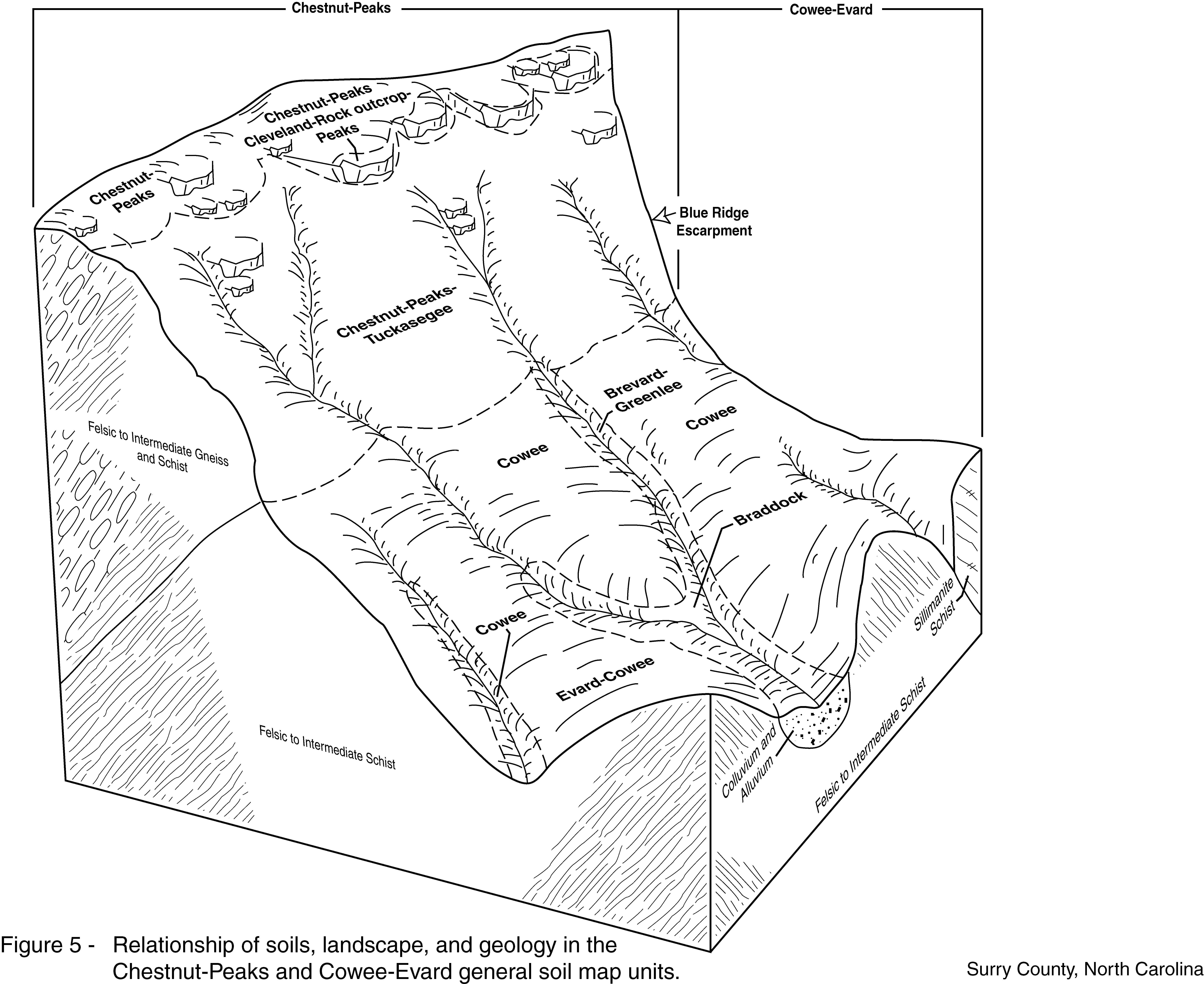
Chestnut-Peaks-Tuckasegee complex, 45 to 90 percent slopes, very rocky | CfF | 4388 | 1427568 | 1jxhl | nc171 | 2005 | 1:24000 |
Cullasaja-Tuckasegee complex, 30 to 50 percent slopes, very stony | 101E | 4003 | 2501801 | 2q8m9 | nc175 | 1968 | 1:15840 |
Cullasaja-Tuckasegee complex, 15 to 30 percent slopes, very stony | 101D | 3709 | 2501800 | 2q8m8 | nc175 | 1968 | 1:15840 |
Cullasaja-Tuckasegee complex, 8 to 15 percent slopes, stony | 101C | 686 | 2501799 | 2q8m7 | nc175 | 1968 | 1:15840 |
Cullasaja-Tuckasegee complex, 15 to 30 percent slopes, very stony | HdE | 140 | 2390385 | 2l7d6 | nc175 | 1968 | 1:15840 |
Cullasaja-Tuckasegee complex, 50 to 95 percent slopes, very stony | 101F | 85 | 2501802 | 2q8mb | nc175 | 1968 | 1:15840 |
Cullasaja-Tuckasegee complex, windswept, 30 to 50 percent slopes, very bouldery | 102E | 32 | 2501866 | 2q8mf | nc175 | 1968 | 1:15840 |
Cullasaja-Tuckasegee complex, 30 to 50 percent slopes, very stony | HdF | 24 | 2390386 | 2l7d7 | nc175 | 1968 | 1:15840 |
Cullasaja-Tuckasegee complex, windswept, 15 to 30 percent slopes, very bouldery | 102D | 20 | 2501865 | 2q8md | nc175 | 1968 | 1:15840 |
Cullasaja-Tuckasegee complex, 15 to 30 percent slopes, very stony | CtD | 1640 | 1912607 | 22670 | nc605 | 2007 | 1:12000 |
Cullasaja-Tuckasegee complex, 30 to 50 percent slopes, very stony | CtE | 1403 | 1912608 | 22671 | nc605 | 2007 | 1:12000 |
Cullasaja-Tuckasegee-Cruso complex, 8 to 15 percent slopes, very stony | CsC | 317 | 622562 | nwtn | nc605 | 2007 | 1:12000 |
Tuckasegee-Cullasaja complex, 15 to 30 percent slopes, very stony | TuD | 4494 | 546815 | lc06 | nc606 | 1991 | 1:12000 |
Tuckasegee-Cullasaja complex, 30 to 50 percent slopes, extremely stony | TvE | 3299 | 546816 | lc07 | nc606 | 1991 | 1:12000 |
Cullasaja-Tuckasegee complex, 30 to 50 percent slopes, very stony | 101E | 48 | 2509028 | 2q1w6 | nc606 | 1991 | 1:12000 |
Cullasaja-Tuckasegee complex, 15 to 30 percent slopes, very stony | 101D | 15 | 2509027 | 2q1w5 | nc606 | 1991 | 1:12000 |
Cullasaja-Tuckasegee complex, windswept, 30 to 50 percent slopes, very bouldery | 102E | 8 | 2509091 | 2q1w7 | nc606 | 1991 | 1:12000 |
Cullasaja-Tuckasegee complex, 30 to 50 percent slopes, very stony | CuE | 364 | 553546 | ll0b | tn640 | 2007 | 1:24000 |
Cullasaja-Tuckasegee complex, 15 to 30 percent slopes, very stony | CuD | 253 | 553547 | ll0c | tn640 | 2007 | 1:24000 |
Tuckasegee-Cullasaja complex, 8 to 15 percent slopes, stony | TuC | 17 | 553534 | lkzy | tn640 | 2007 | 1:24000 |
Tuckasegee-Cullasaja complex, 15 to 30 percent slopes, very stony | TuD | 1 | 3244657 | lc06 | tn640 | 2007 | 1:24000 |
Cullasaja-Tuckasegee complex, 15 to 25 percent slopes, very stony | 13D | 2105 | 581968 | mjl5 | va067 | 2004 | 1:24000 |
Cullasaja-Tuckasegee complex, 25 to 60 percent slopes, very stony | 13E | 1849 | 581969 | mjl6 | va067 | 2004 | 1:24000 |
Cullasaja-Tuckasegee-Dellwood complex, 0 to 15 percent slopes, very stony | 14C | 362 | 581971 | mjl8 | va067 | 2004 | 1:24000 |
Chestnut-Peaks-Tuckasegee complex, 45 to 90 percent slopes, very rocky | 11F | 93 | 1670508 | 1t29c | va077 | 2006 | 1:24000 |
Tuckasegee-Cullasaja complex, 15 to 25 percent slopes, very stony | 47D | 1063 | 1473808 | 1lgm6 | va141 | 2008 | 1:24000 |
Tuckasegee-Cullasaja complex, 25 to 45 percent slopes, very stony | 47E | 525 | 1473809 | 1lgm7 | va141 | 2008 | 1:24000 |
Tuckasegee-Cullasaja complex, 8 to 15 percent slopes, very stony | 47C | 209 | 1473807 | 1lgm5 | va141 | 2008 | 1:24000 |
Cullasaja-Tuckasegee complex, 15 to 35 percent slopes, very stony | 11 | 1289 | 2409549 | 2lwbd | va606 | | 1:24000 |
Cullasaja-Tuckasegee complex, 7 to 15 percent slopes, very stony | 10M | 431 | 2409550 | 2lwbf | va606 | | 1:24000 |
Cullasaja-Tuckasegee complex, 35 to 60 percent slopes, very stony | 12 | 430 | 2409548 | 2lwbc | va606 | | 1:24000 |