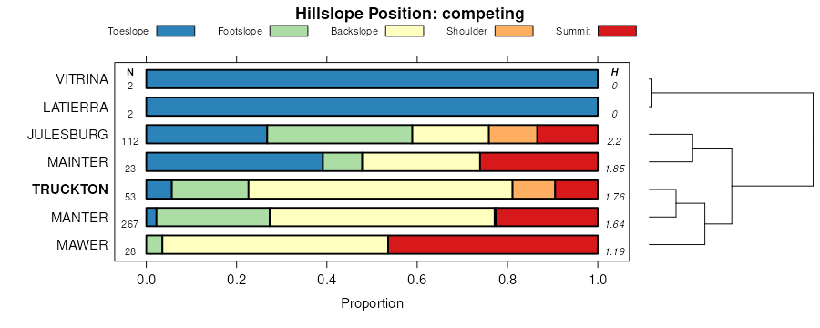
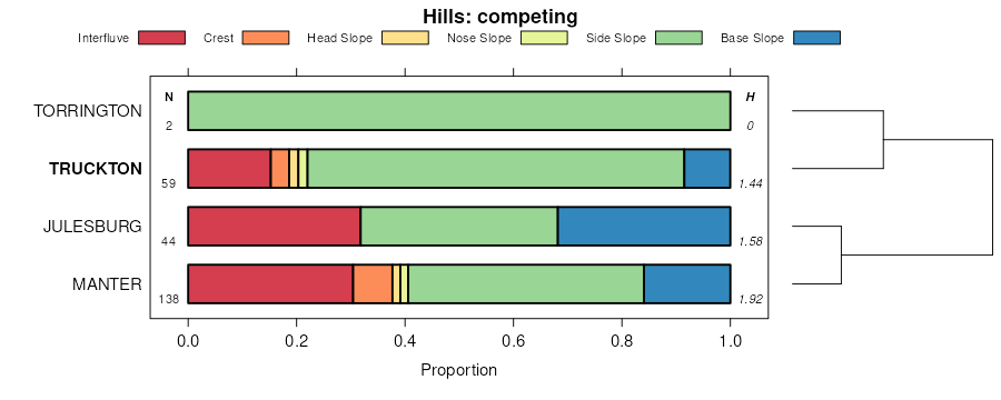
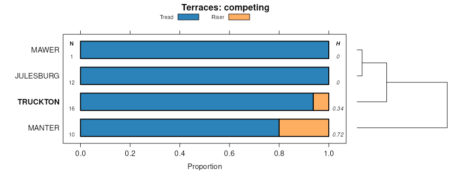
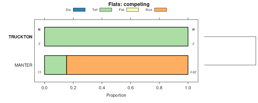
| Truckton loamy sand, 0 to 3 percent slopes | TtB | 16491 | 94083 | 2yvrl | co001 | 1968 | 1:20000 |
Truckton sandy loam, 0 to 3 percent slopes | TuB | 13736 | 94085 | 2yvrf | co001 | 1968 | 1:20000 |
Blakeland-Truckton association | Bt | 9772 | 94048 | 34vt | co001 | 1968 | 1:20000 |
Truckton loamy sand, 3 to 5 percent slopes | TtC | 9078 | 3390163 | 31gjy | co001 | 1968 | 1:20000 |
Truckton loamy sand, 5 to 9 percent slopes | TtD | 4714 | 3390164 | 31gjz | co001 | 1968 | 1:20000 |
Truckton sandy loam, 3 to 5 percent slopes | TuC | 2382 | 94086 | 2yvrg | co001 | 1968 | 1:20000 |
Truckton sandy loam, 5 to 9 percent slopes | TuD | 1401 | 94087 | 2yvrh | co001 | 1968 | 1:20000 |
Bresser-Truckton sandy loams, 3 to 5 percent slopes | BvC | 29317 | 94121 | 34y5 | co005 | 1971 | 1:20000 |
Bresser-Truckton sandy loams, 5 to 20 percent slopes | BvE | 17176 | 94122 | 34y6 | co005 | 1971 | 1:20000 |
Bresser and Truckton soil, 3 to 9 slopes, eroded | BwD2 | 7834 | 94123 | 34y7 | co005 | 1971 | 1:20000 |
Truckton loamy sand, 5 to 9 percent slopes | TrD | 7062 | 3390166 | 31gjz | co005 | 1971 | 1:20000 |
Truckton loamy sand, 3 to 5 percent slopes | TrC | 5130 | 3390165 | 31gjy | co005 | 1971 | 1:20000 |
Truckton loamy sand, 0 to 3 percent slopes | TrB | 2249 | 94167 | 2yvrl | co005 | 1971 | 1:20000 |
Blakeland-Truckton association | Bt | 10 | 3442419 | 31l42 | co031 | 2025 | 1:24000 |
Truckton loamy sand, 0 to 3 percent slopes | TtB | 7 | 3442422 | 31l4c | co031 | 2025 | 1:24000 |
Truckton sandy loam, dry, 1 to 5 percent slopes | 191 | 7769 | 105272 | 3jjw | co073 | 2001 | 1:24000 |
Truckton sandy loam, dry, 5 to 9 percent slopes | 192 | 3411 | 105273 | 3jjx | co073 | 2001 | 1:24000 |
Truckton sandy loam, 0 to 3 percent slopes | 189 | 1894 | 105270 | 2yvrf | co073 | 2001 | 1:24000 |
Truckton sandy loam, 5 to 9 percent slopes | 190 | 759 | 105271 | 2yvrh | co073 | 2001 | 1:24000 |
Truckton sandy loam, 3 to 5 percent slopes | 224 | 758 | 3223698 | 2yvrg | co073 | 2001 | 1:24000 |
Truckton loamy sand, 0 to 3 percent slopes | TuB | 25238 | 110476 | 2yvrl | co087 | 1965 | 1:24000 |
Truckton loamy sand, 3 to 5 percent slopes | TuC | 18051 | 3390167 | 31gjy | co087 | 1965 | 1:24000 |
Truckton loamy sand, 5 to 9 percent slopes | TuD | 3939 | 3390168 | 31gjz | co087 | 1965 | 1:24000 |
Bresser-Truckton sandy loams, 5 to 25 percent slopes | BtE | 16332 | 498706 | jqy9 | co622 | 1968 | 1:20000 |
Bresser and Truckton soils, 3 to 12 percent slopes, eroded | BuD2 | 1409 | 498707 | jqyb | co622 | 1968 | 1:20000 |
Truckton sandy loam, 0 to 3 percent slopes | TrB | 646 | 498774 | 2yvrd | co622 | 1968 | 1:20000 |
Truckton sandy loam, 3 to 9 percent slopes | TrD | 595 | 498775 | 2x0j2 | co622 | 1968 | 1:20000 |
Bresser-Truckton sandy loams, 8 to 25 percent slopes | 9 | 68696 | 496442 | jnl8 | co623 | 1977 | 1:24000 |
Truckton sandy loam, 3 to 9 percent slopes | 41 | 11370 | 496433 | 2x0j2 | co623 | 1977 | 1:24000 |
Truckton-Renohill complex, 8 to 25 percent slopes | 42 | 6185 | 496434 | jnl0 | co623 | 1977 | 1:24000 |
Bresser-Truckton-Blakeland complex, 3 to 9 percent slopes | BtD | 44318 | 95290 | 2xst2 | co624 | 1963 | 1:20000 |
Yoder-Truckton-Lismas complex | Yt | 20205 | 95353 | 366x | co624 | 1963 | 1:20000 |
Truckton sandy loam, 5 to 9 percent slopes | TkD | 6664 | 95337 | 2yvrh | co624 | 1963 | 1:20000 |
Truckton sandy loam, 3 to 5 percent slopes | TkC | 4798 | 95336 | 2yvrg | co624 | 1963 | 1:20000 |
Truckton, Bresser, and Blakeland soils, 5 to 20 percent slopes, eroded | TrE2 | 4055 | 95338 | 366f | co624 | 1963 | 1:20000 |
Truckton sandy loam, 0 to 3 percent slopes | TkB | 776 | 95335 | 2yvrf | co624 | 1963 | 1:20000 |
Truckton sandy loam, 3 to 9 percent slopes | 97 | 72659 | 95463 | 2x0j2 | co625 | 1975 | 1:24000 |
Truckton sandy loam, 0 to 3 percent slopes | 96 | 29401 | 95462 | 2yvrd | co625 | 1975 | 1:24000 |
Truckton loamy sand, 1 to 9 percent slopes | 95 | 14708 | 95461 | 2yvrm | co625 | 1975 | 1:24000 |
Truckton-Bresser complex, eroded | 100 | 10173 | 95358 | 3672 | co625 | 1975 | 1:24000 |
Truckton-Bresser sandy loams, 5 to 20 percent slopes | 99 | 6430 | 95465 | 2yvrp | co625 | 1975 | 1:24000 |
Truckton-Blakeland complex, 9 to 20 percent slopes | 98 | 2249 | 95464 | 2yvrn | co625 | 1975 | 1:24000 |
Truckton sandy loam, 0 to 3 percent slopes | 158 | 685 | 497438 | 2yvrd | co641 | 1980 | 1:24000 |
Truckton sandy loam, 3 to 9 percent slopes | 159 | 323 | 497439 | 2x0j2 | co641 | 1980 | 1:24000 |