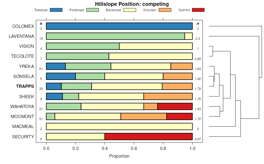
| Trapps channery loam, 25 to 60 percent slopes | 298F | 131 | 2995527 | 4wkc | mt603 | 1989 | 1:24000 |
Trapps channery loam, 4 to 25 percent slopes | 298D | 81 | 2995526 | 4wkb | mt603 | 1989 | 1:24000 |
Trapps channery loam, 60 to 80 percent slopes | 298G | 1 | 2995528 | 4wkd | mt603 | 1989 | 1:24000 |
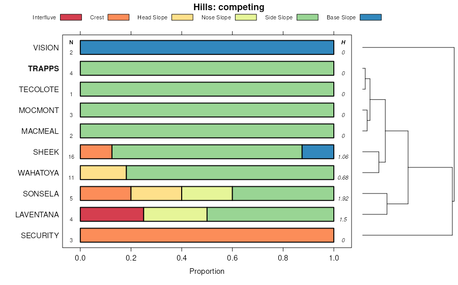
Silverchief-Trapps complex, 8 to 15 percent slopes | 599D | 151 | 154953 | 567h | mt616 | 2003 | 1:24000 |
Trapps gravelly loam, 35 to 60 percent slopes | 98F | 122 | 155198 | 56hd | mt616 | 2003 | 1:24000 |
Trapps-Yreka stony loams, 8 to 25 percent slopes | 198E | 5 | 154631 | 55x3 | mt616 | 2003 | 1:24000 |
Trapps gravelly loam, 15 to 35 percent slopes | 98E | 6844 | 144671 | 4vjt | mt621 | 1997 | 1:24000 |
Trapps gravelly loam, 35 to 60 percent slopes | 98F | 4339 | 144672 | 4vjv | mt621 | 1997 | 1:24000 |
Silverchief-Trapps complex, 15 to 35 percent slopes | 599E | 2224 | 144522 | 4vd0 | mt621 | 1997 | 1:24000 |
Trapps gravelly loam, 60 to 80 percent slopes | 98G | 491 | 144673 | 4vjw | mt621 | 1997 | 1:24000 |
Trapps gravelly loam, 8 to 15 percent slopes | 98D | 373 | 144670 | 4vjs | mt621 | 1997 | 1:24000 |
Silverchief-Trapps complex, 35 to 60 percent slopes | 599F | 327 | 144523 | 4vd1 | mt621 | 1997 | 1:24000 |
Silverchief-Trapps complex, 8 to 15 percent slopes | 599D | 166 | 144521 | 4vcz | mt621 | 1997 | 1:24000 |
Trapps-Yreka complex, 4 to 8 percent slopes | 198C | 143 | 144265 | 4v3q | mt621 | 1997 | 1:24000 |
Trapps-Yreka complex, 8 to 25 percent slopes | 198E | 32 | 144266 | 4v3r | mt621 | 1997 | 1:24000 |
Trapps gravelly loam, 15 to 30 percent slopes | 164 | 1778 | 145067 | 4vyl | mt629 | 1991 | 1:20000 |
Trapps gravelly loam, 8 to 15 percent slopes | 163 | 290 | 145066 | 4vyk | mt629 | 1991 | 1:20000 |
Whitecow, cool-Trapps, dry channery loams, 25 to 60 percent slopes | 285F | 4326 | 147771 | 4yrt | mt630 | 1991 | 1:24000 |
Trapps-Whitecow-Warneke channery loams, 25 to 60 percent slopes | 985F | 2412 | 147949 | 4yyk | mt630 | 1991 | 1:24000 |
Trapps channery loam, 25 to 60 percent slopes | 484F | 2358 | 147827 | 4ytm | mt630 | 1991 | 1:24000 |
Trapps stony loam, 8 to 25 percent slopes | 584D | 1875 | 147863 | 4yvs | mt630 | 1991 | 1:24000 |
Trapps-Warneke channery loams, 25 to 60 percent slopes | 984F | 1358 | 147948 | 4yyj | mt630 | 1991 | 1:24000 |
Trapps-Yreka complex, 8 to 25 percent slopes | 198E | 2088 | 1703242 | 1v5c9 | mt635 | 2006 | 1:24000 |
Silverchief-Trapps complex, 35 to 60 percent slopes | 599F | 621 | 1702976 | 1v52q | mt635 | 2006 | 1:24000 |
Silverchief-Trapps complex, 15 to 35 percent slopes | 599E | 318 | 1702975 | 1v52p | mt635 | 2006 | 1:24000 |
Trapps gravelly loam, 35 to 60 percent slopes | 98F | 269 | 1703002 | 1v53k | mt635 | 2006 | 1:24000 |
Trapps gravelly loam, 15 to 35 percent slopes | 98E | 189 | 1703001 | 1v53j | mt635 | 2006 | 1:24000 |
Trapps gravelly loam, 30 to 60 percent slopes | 109 | 10871 | 145397 | 4w97 | mt638 | 1985 | 1:24000 |
Trapps gravelly loam, 8 to 30 percent slopes | 108 | 1192 | 145396 | 4w96 | mt638 | 1985 | 1:24000 |
Wilde-Trapps families complex, mountain uplands and ridges | 33B35 | 167 | 2422677 | 2m9zw | mt638 | 1985 | 1:24000 |
Trapps-Wilde families complex, dissected mountain slopes | 31B39 | 28 | 2422671 | 2m9zp | mt638 | 1985 | 1:24000 |
Trapps gravelly loam, 35 to 60 percent slopes | 98F | 4430 | 145980 | 4wx1 | mt644 | 1995 | 1:24000 |
Silverchief-Trapps complex, 15 to 35 percent slopes | 599E | 4205 | 145829 | 4wr5 | mt644 | 1995 | 1:24000 |
Trapps gravelly loam, 15 to 35 percent slopes | 98E | 3925 | 145979 | 4wx0 | mt644 | 1995 | 1:24000 |
Trapps channery loam, 25 to 60 percent slopes | 298F | 3093 | 145649 | 4wkc | mt644 | 1995 | 1:24000 |
Trapps-Yreka stony loams, 8 to 25 percent slopes | 198E | 3077 | 145593 | 4whk | mt644 | 1995 | 1:24000 |
Trapps channery loam, 4 to 25 percent slopes | 298D | 1495 | 145648 | 4wkb | mt644 | 1995 | 1:24000 |
Silverchief-Trapps complex, 8 to 15 percent slopes | 599D | 1199 | 145828 | 4wr4 | mt644 | 1995 | 1:24000 |
Trapps channery loam, 60 to 80 percent slopes | 298G | 242 | 145650 | 4wkd | mt644 | 1995 | 1:24000 |
Trapps family, dissected mountain slopes | 31B28 | 2075 | 633769 | p8h5 | mt645 | 2013 | 1:12000 |
Trapps-Wilde families, complex, dissected mountain slopes | 31B39 | 1643 | 633770 | p8h6 | mt645 | 2013 | 1:12000 |
Trapps-Bignell families, complex, steep mountain slopes | 30B32 | 880 | 754412 | tb0w | mt645 | 2013 | 1:12000 |
Wilde-Trapps families, complex, mountain uplands and ridges | 33B35 | 413 | 1389555 | 1hmyc | mt645 | 2013 | 1:12000 |
Wilde-Trapps families, complex, steep mountain slopes | 30B35 | 310 | 757744 | tfhc | mt645 | 2013 | 1:12000 |
Trapps-Wilde families, complex, dissected mountain slopes | 31B39 | 6684 | 150259 | 51c2 | mt647 | 2007 | 1:24000 |
Trapps-Bignell families, complex, steep mountain slopes | 30B32 | 4565 | 150228 | 51b2 | mt647 | 2007 | 1:24000 |
Trapps family, dissected mountain slopes | 31B28 | 3177 | 150257 | 51c0 | mt647 | 2007 | 1:24000 |
Wilde-Trapps families, complex, steep mountain slopes | 30B35 | 2841 | 150230 | 51b4 | mt647 | 2007 | 1:24000 |
Wilde-Trapps families, complex, mountain ridges | 33B35 | 1353 | 150300 | 51dd | mt647 | 2007 | 1:24000 |
Wilde-Trapps-Tolman families, association, dissected mountain slopes | 31W35 | 116 | 150275 | 51cl | mt647 | 2007 | 1:24000 |
Trapps-Shawmut complex, 1 to 20 percent slopes, extremely stony | 3301 | 118 | 3136840 | 2ypn8 | wy629 | | 1:24000 |
Trapps-Shawmut complex, 1 to 20 percent slopes, extremely stony | 3301 | 77 | 3253358 | 2ypn8 | wy656 | 2008 | 1:24000 |


