| Tonti gravelly silt loam, 3 to 8 percent slopes | 39 | 4054 | 2804490 | 2ybmr | ar005 | 1978 | 1:20000 |
Tonti gravelly silt loam, 3 to 8 percent slopes | TsC | 44677 | 565054 | 2ybmr | ar007 | 1973 | 1:20000 |
Tonti gravelly silt loam, 3 to 8 percent slopes | ToC | 2600 | 564550 | 2ybmr | ar075 | 1973 | 1:20000 |
Tonti gravelly silt loam, 8 to 12 percent slopes | ToD | 2400 | 564551 | 2ybmp | ar075 | 1973 | 1:20000 |
Tonti gravelly silt loam, 3 to 8 percent slopes | 47 | 6365 | 565949 | 2ybmr | ar087 | 1982 | 1:20000 |
Tonti gravelly silt loam, 3 to 8 percent slopes | 39 | 2167 | 2804547 | 2ybmr | ar089 | 1978 | 1:20000 |
Tonti silt loam, 2 to 5 percent slopes | 9280 | 2754 | 1426906 | 1jwt7 | ks021 | 1983 | 1:24000 |
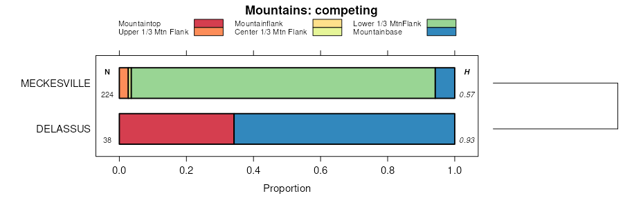
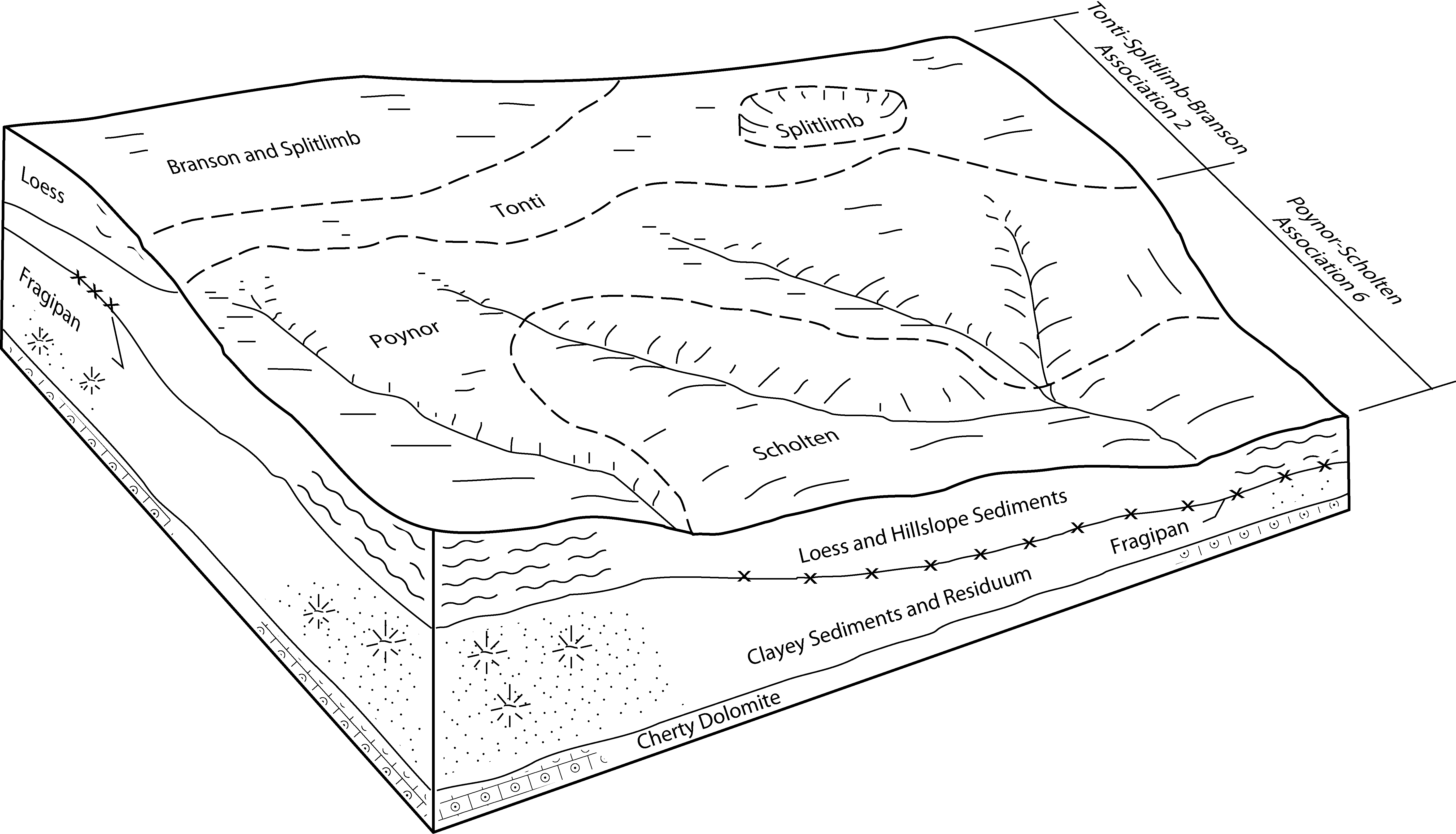
Scholten-Tonti complex, 3 to 8 percent slopes | 73121 | 54709 | 2534818 | 2qphv | mo009 | 1990 | 1:24000 |
Tonti silt loam, 1 to 3 percent slopes | 70026 | 13371 | 2533993 | 2qpbw | mo009 | 1990 | 1:24000 |
Scholten-Tonti complex, karst, 3 to 8 percent slopes | 73980 | 218 | 1862036 | 20hlp | mo009 | 1990 | 1:24000 |
Tonti silt loam, 3 to 8 percent slopes | 70022 | 1979 | 2533970 | 2qpbr | mo035 | 1988 | 1:24000 |
Tonti-Hogcreek complex, 3 to 8 percent slopes | 73298 | 21 | 2536038 | 2qpxg | mo035 | 1988 | 1:24000 |
Tonti silt loam, 8 to 15 percent slopes | 73386 | 18 | 2502480 | 2vxsl | mo035 | 1988 | 1:24000 |
Tonti silt loam, 3 to 8 percent slopes | 70022 | 23572 | 2533956 | 2qpbr | mo043 | 1982 | 1:24000 |
Tonti silt loam, 1 to 3 percent slopes | 70026 | 4441 | 2533994 | 2qpbw | mo043 | 1982 | 1:24000 |
Tonti silt loam, karst, 3 to 8 percent slopes | 70156 | 3789 | 2534248 | 2qpdv | mo043 | 1982 | 1:24000 |
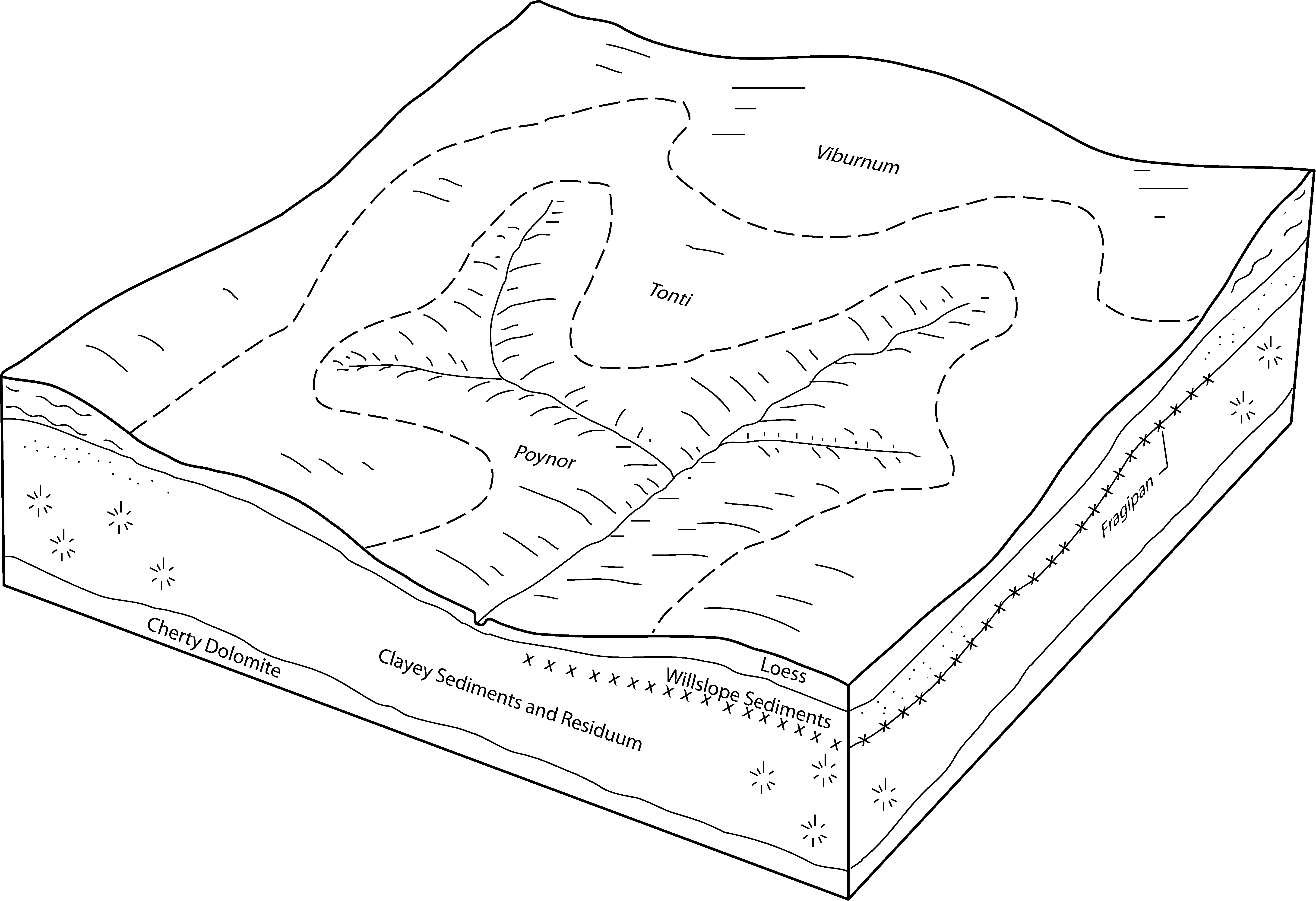
Viburnum-Tonti complex, 1 to 8 percent slopes | 73166 | 3901 | 2534892 | 2qpjd | mo055 | 2003 | 1:24000 |
Tonti-Hogcreek complex, 3 to 8 percent slopes | 73298 | 401 | 2536035 | 2qpxg | mo065 | 1971 | 1:24000 |
Scholten-Tonti complex, 3 to 15 percent slopes | 73183 | 218 | 2534938 | 2qpjs | mo065 | 1971 | 1:24000 |
Viburnum-Tonti complex, 1 to 8 percent slopes | 73166 | 192 | 2534893 | 2qpjd | mo065 | 1971 | 1:24000 |
Tonti silt loam, 1 to 3 percent slopes | 70026 | 122 | 2534001 | 2qpbw | mo065 | 1971 | 1:24000 |
Tonti silt loam, 3 to 8 percent slopes | 70022 | 94 | 2533965 | 2qpbr | mo065 | 1971 | 1:24000 |
Scholten-Tonti complex, 3 to 8 percent slopes | 73121 | 7877 | 2534819 | 2qphv | mo067 | 2004 | 1:24000 |
Tonti silt loam, 1 to 3 percent slopes | 70026 | 2544 | 2533995 | 2qpbw | mo067 | 2004 | 1:24000 |
Tonti silt loam, 3 to 8 percent slopes | 70022 | 2334 | 2533957 | 2qpbr | mo067 | 2004 | 1:24000 |
Fanchon-Tonti complex, 3 to 8 percent slopes | 73242 | 2268 | 2535940 | 2qpwn | mo067 | 2004 | 1:24000 |
Tonti silt loam, 3 to 8 percent slopes | 70022 | 2696 | 2533963 | 2qpbr | mo077 | 1979 | 1:24000 |
Tonti silt loam, karst, 3 to 8 percent slopes | 70156 | 760 | 2534247 | 2qpdv | mo077 | 1979 | 1:24000 |
Fanchon-Tonti complex, 3 to 8 percent slopes | 73242 | 56773 | 2535941 | 2qpwn | mo091 | 2004 | 1:24000 |
Kenaga-Egyptgrove-Tonti complex, karst, 3 to 15 percent slopes | 73304 | 15629 | 691966 | r71h | mo091 | 2004 | 1:24000 |
Fanchon-Tonti complex, 1 to 3 percent slopes | 73313 | 4563 | 2536076 | 2qpxs | mo091 | 2004 | 1:24000 |
Tonti-Hogcreek complex, 3 to 8 percent slopes | 73298 | 4125 | 2536036 | 2qpxg | mo091 | 2004 | 1:24000 |
Tonti silt loam, 3 to 8 percent slopes | 70022 | 1058 | 2533966 | 2qpbr | mo091 | 2004 | 1:24000 |
Tonti silt loam, 1 to 3 percent slopes | 70026 | 32 | 2534002 | 2qpbw | mo091 | 2004 | 1:24000 |
Tonti-Portia complex, 3 to 8 percent slopes | 73337 | 106 | 2502350 | 2vxs6 | mo093 | 1988 | 1:24000 |
Tonti silt loam, 3 to 8 percent slopes | 70022 | 989 | 2533958 | 2qpbr | mo097 | 2000 | 1:24000 |
Tonti silt loam, 3 to 8 percent slopes | 70022 | 6498 | 2533967 | 2qpbr | mo105 | 1997 | 1:24000 |
Tonti silt loam, 3 to 8 percent slopes | 70022 | 2673 | 2533964 | 2qpbr | mo109 | 1979 | 1:24000 |
Tonti silt loam, 1 to 3 percent slopes | 70026 | 2264 | 2534000 | 2qpbw | mo109 | 1979 | 1:24000 |
Scholten-Tonti complex, 3 to 8 percent slopes | 73121 | 1630 | 2534817 | 2qphv | mo109 | 1979 | 1:24000 |
Tonti silt loam, 3 to 8 percent slopes | 70022 | 1632 | 2533959 | 2qpbr | mo119 | 2004 | 1:24000 |
Tonti silt loam, 1 to 3 percent slopes | 70026 | 520 | 2533996 | 2qpbw | mo119 | 2004 | 1:24000 |
Tonti silt loam, 3 to 8 percent slopes | 70022 | 43066 | 2533960 | 2qpbr | mo145 | 1984 | 1:24000 |
Tonti silt loam, 1 to 3 percent slopes | 70026 | 1326 | 2533997 | 2qpbw | mo145 | 1984 | 1:24000 |
Scholten-Tonti complex, 3 to 8 percent slopes | 73121 | 37 | 2534820 | 2qphv | mo145 | 1984 | 1:24000 |
Fanchon-Tonti complex, 3 to 8 percent slopes | 73242 | 24508 | 2535943 | 2qpwn | mo149 | 2004 | 1:24000 |
Tonti-Taterhill complex, 3 to 8 percent slopes | 73317 | 15221 | 1154336 | 17r5n | mo149 | 2004 | 1:24000 |
Tonti silt loam, 3 to 8 percent slopes | 70022 | 5621 | 2533971 | 2qpbr | mo149 | 2004 | 1:24000 |
Tonti-Hogcreek complex, 3 to 8 percent slopes | 73298 | 1418 | 2536039 | 2qpxg | mo149 | 2004 | 1:24000 |
Tonti silt loam, 8 to 15 percent slopes | 73386 | 150 | 2502481 | 2vxsl | mo149 | 2004 | 1:24000 |
Tonti silt loam, 1 to 3 percent slopes | 70026 | 4123 | 2534003 | 2qpbw | mo153 | 2003 | 1:24000 |
Fanchon-Tonti complex, 3 to 8 percent slopes | 73242 | 2611 | 2535942 | 2qpwn | mo153 | 2003 | 1:24000 |
Viburnum-Tonti complex, 1 to 8 percent slopes | 73166 | 26515 | 2534894 | 2qpjd | mo161 | 2001 | 1:24000 |
Scholten-Tonti complex, 3 to 15 percent slopes | 73183 | 12312 | 2534939 | 2qpjs | mo161 | 2001 | 1:24000 |
Viburnum-Tonti complex, 1 to 8 percent slopes | 73166 | 446 | 2534895 | 2qpjd | mo169 | 1984 | 1:24000 |
Tonti silt loam, 3 to 8 percent slopes | 70022 | 62 | 2533968 | 2qpbr | mo169 | 1984 | 1:24000 |
Scholten-Tonti complex, 3 to 15 percent slopes | 73183 | 36 | 2534937 | 2qpjs | mo169 | 1984 | 1:24000 |
Tonti-Hogcreek complex, 3 to 8 percent slopes | 73298 | 15568 | 2536037 | 2qpxg | mo179 | 2004 | 1:24000 |
Tonti-Portia complex, 3 to 8 percent slopes | 73337 | 782 | 2502351 | 2vxs6 | mo179 | 2004 | 1:24000 |
Tonti silt loam, 3 to 8 percent slopes | 70022 | 6439 | 2533972 | 2qpbr | mo181 | 1982 | 1:24000 |
Tonti silt loam, 8 to 15 percent slopes | 73386 | 435 | 2502482 | 2vxsl | mo181 | 1982 | 1:24000 |
Fanchon-Tonti complex, 3 to 8 percent slopes | 73242 | 5 | 2535944 | 2qpwn | mo181 | 1982 | 1:24000 |
Tonti-Hogcreek complex, 3 to 8 percent slopes | 73298 | 18417 | 2536034 | 2qpxg | mo203 | 2004 | 1:24000 |
Tonti silt loam, 3 to 8 percent slopes | 70022 | 10260 | 2533955 | 2qpbr | mo203 | 2004 | 1:24000 |
Fanchon-Tonti complex, 3 to 8 percent slopes | 73242 | 1437 | 2535939 | 2qpwn | mo203 | 2004 | 1:24000 |
Fanchon-Tonti complex, 1 to 3 percent slopes | 73313 | 838 | 2536075 | 2qpxs | mo203 | 2004 | 1:24000 |
Tonti-Portia complex, 3 to 8 percent slopes | 73337 | 547 | 2502352 | 2vxs6 | mo203 | 2004 | 1:24000 |
Tonti silt loam, 8 to 15 percent slopes | 73386 | 530 | 2502483 | 2vxsl | mo203 | 2004 | 1:24000 |
Tonti silt loam, 1 to 3 percent slopes | 70026 | 229 | 2533992 | 2qpbw | mo203 | 2004 | 1:24000 |
Scholten-Tonti complex, 3 to 8 percent slopes | 73121 | 2325 | 2534821 | 2qphv | mo209 | 1998 | 1:24000 |
Tonti silt loam, 1 to 3 percent slopes | 70026 | 2024 | 2533998 | 2qpbw | mo209 | 1998 | 1:24000 |
Horneybuck-Tonti complex, 3 to 8 percent slopes | 73115 | 624 | 889831 | yvy7 | mo209 | 1998 | 1:24000 |
Tonti silt loam, 3 to 8 percent slopes | 70022 | 38826 | 2533969 | 2qpbr | mo215 | 2002 | 1:24000 |
Tonti silt loam, 1 to 3 percent slopes | 70026 | 18327 | 2534004 | 2qpbw | mo215 | 2002 | 1:24000 |
Viburnum-Tonti complex, 1 to 8 percent slopes | 73166 | 1355 | 2534891 | 2qpjd | mo221 | 2003 | 1:24000 |
Tonti silt loam, 3 to 8 percent slopes | 70022 | 36208 | 2533961 | 2qpbr | mo225 | 1988 | 1:24000 |
Tonti silt loam, 3 to 8 percent slopes | 70022 | 1426 | 2533962 | 2qpbr | mo229 | 1979 | 1:24000 |
Tonti silt loam, 1 to 3 percent slopes | 70026 | 260 | 2533999 | 2qpbw | mo229 | 1979 | 1:24000 |
Scholten-Tonti complex, 3 to 8 percent slopes | 73121 | 146 | 2534822 | 2qphv | mo229 | 1979 | 1:24000 |
Tonti gravelly silt loam, 0 to 3 percent slopes | DkA | 22083 | 571780 | m5zj | ok001 | 1963 | 1:24000 |
Tonti gravelly silt loam, 1 to 3 percent slopes | LoB | 22199 | 571819 | 2t6sh | ok021 | 1967 | 1:24000 |
Doniphan-Tonti complex, 3 to 5 percent slopes | BlC | 16617 | 571844 | m61l | ok041 | 1967 | 1:24000 |
Tonti gravelly silt loam, 1 to 3 percent slopes | LoB | 9322 | 571861 | 2t6sh | ok041 | 1967 | 1:24000 |