| Toccoa soils | Ta | 1706 | 523028 | kk7w | al019 | 1973 | 1:20000 |
Toccoa fine sandy loam | To | 5464 | 328554 | c0wj | al021 | 1967 | 1:20000 |
Toccoa soils, local alluvium | Tr | 732 | 328555 | c0wk | al021 | 1967 | 1:20000 |
Toccoa sandy loam, 0 to 2 percent slopes, occasionally flooded | Ts | 1000 | 122796 | 2twx1 | al027 | 1971 | 1:20000 |
Chewacla, Cartecay and Toccoa soils, 0 to 1 percent slopes, frequently flooded | CHA | 26127 | 1895715 | 2xn6v | al037 | 2006 | 1:24000 |
Toccoa fine sandy loam, 0 to 2 percent slopes, occasionally flooded | ToA | 2033 | 1895741 | 21mny | al037 | 2006 | 1:24000 |
Chewacla, Cartecay and Toccoa soils, 0 to 1 percent slopes, frequently flooded | Ma | 38108 | 329277 | 2xn6v | al051 | 1948 | 1:20000 |
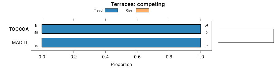
Toccoa sandy loam | 59 | 740 | 329430 | c1ss | al055 | 1976 | 1:20000 |
Toccoa sandy loam, 0 to 2 percent slopes, frequently flooded | 39 | 13775 | 330222 | 2twx0 | al081 | 1979 | 1:20000 |
Toccoa fine sandy loam, 0 to 1 percent slopes, occasionally flooded | TcA | 1177 | 330496 | c2x5 | al087 | 1997 | 1:24000 |
Toccoa fine sandy loam, gently undulating, occasionally flooded | ToB | 942 | 330497 | c2x6 | al087 | 1997 | 1:24000 |
Congaree-Toccoa complex, gently undulating, occasionally flooded | CtB | 5390 | 331370 | c3tc | al113 | 1997 | 1:24000 |
Toccoa sandy loam, 0 to 2 percent slopes | TcA | 900 | 331415 | c3vt | al115 | 1983 | 1:24000 |
Toccoa loams | To | 5834 | 523264 | kkhh | al121 | 1969 | 1:20000 |
Chewacla, Cartecay and Toccoa soils, 0 to 1 percent slopes, frequently flooded | CHA | 32215 | 1476401 | 2xn6v | al123 | 2005 | 1:24000 |
Toccoa fine sandy loam, 0 to 2 percent slopes, occasionally flooded | ToA | 2930 | 1476449 | 1lkcd | al123 | 2005 | 1:24000 |
Toccoa sandy loam, 0 to 3 percent slopes, occasionally flooded | ToA | 2730 | 1611872 | 1r38w | ga015 | 2013 | 1:12000 |
Toccoa sandy loam, 0 to 2 percent slopes, frequently flooded | ToA | 990 | 1018608 | 2twx0 | ga035 | 2003 | 1:24000 |
Toccoa sandy loam, 0 to 2 percent slopes, occasionally flooded | Toc | 8165 | 124220 | 2twx1 | ga067 | 1969 | 1:15840 |
Toccoa sandy loam, local alluvium | Tod | 730 | 124221 | 4584 | ga067 | 1969 | 1:15840 |
Toccoa sandy loam, 0 to 2 percent slopes, frequently flooded | Tf | 5046 | 124280 | 2twx0 | ga089 | 1979 | 1:15840 |
Toccoa sandy loam, high | To | 838 | 124281 | 45b2 | ga089 | 1979 | 1:15840 |
Chewacla, Cartecay, and Toccoa soils, 0 to 2 percent slopes, frequently flooded | Alp | 7365 | 126226 | 2y6q1 | ga097 | 1960 | 1:15840 |
Toccoa and Chewacla soils, 0 to 2 percent slopes, occasionally flooded | Alm | 1020 | 126225 | 2xnyy | ga097 | 1960 | 1:15840 |
Toccoa and Chewacla soils, 0 to 2 percent slopes, occasionally flooded | Ab | 4925 | 124294 | 2xnyy | ga117 | 1957 | 1:20000 |
Cartecay-Toccoa complex, 0 to 2 percent slopes, occasionally flooded | CaA | 21640 | 1654028 | 1sj4r | ga121 | 2007 | 1:12000 |
Toccoa fine sandy loam, 0 to 4 percent slopes, frequently flooded | ToA | 8740 | 725706 | sc4w | ga135 | 1966 | 1:15840 |
Toccoa-Cartecay complex, 0 to 2 percent slopes, occasionally flooded | Alm | 1165 | 124453 | 2xnyt | ga137 | 1960 | 1:20000 |
Toccoa-Cartecay complex, 0 to 2 percent slopes, occasionally flooded | Alm | 2602 | 124564 | 2xnyt | ga147 | 1961 | 1:20000 |
Toccoa fine sandy loam, 0 to 3 percent slopes, frequently flooded | ToA | 2410 | 126848 | 47zw | ga159 | 1997 | 1:24000 |
Chewacla, Cartecay, and Toccoa soils, 0 to 2 percent slopes, frequently flooded | Alp | 19370 | 124660 | 2y6q1 | ga199 | 1960 | 1:15840 |
Toccoa and Chewacla soils, 0 to 2 percent slopes, occasionally flooded | Alm | 1520 | 124659 | 2xnys | ga199 | 1960 | 1:15840 |
Toccoa sandy loam, 0 to 2 percent slopes, frequently flooded | ToA | 5160 | 2200564 | 2twx0 | ga207 | 2007 | 1:24000 |
Toccoa loamy sand, 0 to 3 percent slopes, frequently flooded | ToA | 5980 | 142646 | 4sfh | ga211 | 1998 | 1:24000 |
Toccoa sandy loam | To | 4245 | 124852 | 45xh | ga215 | 1980 | 1:15840 |
Toccoa fine sandy loam, occasionally flooded | To | 10760 | 124907 | 45z8 | ga221 | 1984 | 1:20000 |
Toccoa sandy loam, 0 to 3 percent slopes, occasionally flooded | ToA | 3820 | 2511208 | tryv | ga223 | 2010 | 1:12000 |
Chewacla, Cartecay, and Toccoa soils, 0 to 2 percent slopes, frequently flooded | Alp | 4800 | 124938 | 2y6q1 | ga255 | 1962 | 1:15840 |
Toccoa and Chewacla soils, 0 to 2 percent slopes, occasionally flooded | Alm | 1210 | 124937 | 2xnys | ga255 | 1962 | 1:15840 |
Chewacla, Cartecay, and Toccoa soils, 0 to 2 percent slopes, frequently flooded | Alp | 10440 | 124999 | 2y6q1 | ga297 | 1962 | 1:15840 |
Toccoa and Chewacla soils, 0 to 2 percent slopes, occasionally flooded | Alm | 2830 | 124998 | 2xnys | ga297 | 1962 | 1:15840 |
Congaree and Toccoa soils | Cot | 24365 | 125202 | 468s | ga604 | 1972 | 1:20000 |
Starr and Toccoa soils | Sen | 975 | 125231 | 469q | ga604 | 1972 | 1:20000 |
Toccoa sandy loam, 0 to 2 percent slopes, occasionally flooded | Toc | 15065 | 125289 | 2twx1 | ga605 | 1967 | 1:15840 |
Toccoa sandy loam, local alluvium | Tod | 1245 | 125290 | 46cm | ga605 | 1967 | 1:15840 |
Toccoa soils | To | 13570 | 125332 | 46dz | ga606 | 1973 | 1:20000 |
Toccoa fine sandy loam | Tk | 10715 | 531303 | ktvt | ga621 | 1975 | 1:20000 |
Toccoa complex | Toe | 13620 | 531373 | kty2 | ga622 | 1967 | 1:20000 |
Toccoa sandy loam, 0 to 2 percent slopes, frequently flooded | TS | 5400 | 125538 | 2twx0 | ga625 | 1976 | 1:20000 |
Toccoa sandy loam, 0 to 2 percent slopes, occasionally flooded | To | 2385 | 125539 | 2twx1 | ga625 | 1976 | 1:20000 |
Toccoa loam | Tv | 11085 | 125579 | 46ny | ga628 | 1977 | 1:20000 |
Toccoa sandy loam, 0 to 2 percent slopes, occasionally flooded | Toc | 13010 | 125694 | 2twx1 | ga632 | 1967 | 1:15840 |
Toccoa fine sandy loam | To | 27738 | 125742 | 46v6 | ga636 | 1975 | 1:20000 |
Toccoa and Chewacla soils, 0 to 2 percent slopes, occasionally flooded | Alm | 3950 | 125745 | 2xnys | ga642 | 1967 | 1:15840 |
Toccoa loam, occasionally flooded | To | 14635 | 127121 | 488p | ga645 | 1995 | 1:12000 |
Toccoa and Congaree soils, frequently flooded | TCA | 6505 | 127383 | 48k4 | ga649 | 1992 | 1:12000 |
Toccoa fine sandy loam, rarely flooded | Ta | 1400 | 127384 | 48k5 | ga649 | 1992 | 1:12000 |
Toccoa fine sandy loam | To | 2180 | 531409 | ktz7 | ga651 | 1976 | 1:20000 |
Toccoa sandy loam, 0 to 2 percent slopes, frequently flooded | ToA | 10307 | 747895 | 2twx0 | ga655 | 2012 | 1:24000 |
Toccoa loam, 0 to 2 percent slopes, occasionally flooded | ToA | 4601 | 117099 | 3xvd | nc045 | 2000 | 1:24000 |
Riverview and Toccoa soils, 0 to 2 percent slopes, occasionally flooded | RtA | 1356 | 2424275 | 2mcnf | nc097 | 2011 | 1:12000 |
Toccoa sandy loam, 0 to 3 percent slopes, occasionally flooded | ToA | 2880 | 117652 | 3yf7 | nc161 | 1997 | 1:24000 |
Toccoa sandy loam | Tc | 12480 | 1155021 | 17rwr | sc001 | 1976 | 1:20000 |
Toccoa-Cartecay complex | Tc | 5145 | 131816 | 4f54 | sc007 | 1975 | 1:20000 |
Worsham sandy loam, 0 to 6 percent slopes | WoB | 1713 | 132175 | 4fjq | sc021 | 1960 | 1:20000 |
Toccoa loam | To | 13820 | 132202 | 4fkl | sc023 | 1977 | 1:20000 |
Toccoa sandy loam | To | 12933 | 129884 | 4c4t | sc037 | 1978 | 1:20000 |
Toccoa loam | To | 20550 | 129926 | 4c65 | sc039 | 1977 | 1:20000 |
Cartecay and Toccoa soils | Cb | 23441 | 132466 | 4fv3 | sc045 | 1972 | 1:20000 |
Cartecay and Toccoa soils | Ca | 16867 | 130027 | 4c9f | sc047 | 1973 | 1:20000 |
Toccoa-Cartecay complex | Tc | 289 | 2394371 | 2lcjs | sc057 | 1967 | 1:20000 |
Cartecay-Toccoa complex | Ca | 23885 | 130352 | 4cmx | sc059 | 1970 | 1:20000 |
Toccoa fine sandy loam | To | 1966 | 130542 | 4cv1 | sc063 | 1972 | 1:20000 |
Cartecay and Toccoa soils | Ca | 15787 | 130680 | 4czh | sc065 | 1973 | 1:20000 |
Toccoa sandy loam, 0 to 3 percent slopes, frequently flooded | ToA | 12531 | 639542 | pghd | sc071 | 2005 | 1:24000 |
Toccoa sandy loam, 0 to 2 percent slopes, occasionally flooded | 49A | 3747 | 1459539 | 1kzrx | sc071 | 2005 | 1:24000 |
Toccoa soils | To | 9010 | 131076 | 4dd8 | sc077 | 1967 | 1:20000 |
Toccoa loam | To | 2702 | 131133 | 4dg3 | sc079 | 1976 | 1:20000 |
Toccoa-Chewacla complex, 0 to 2 percent slopes, frequently flooded | Mv | 16440 | 131222 | 2ycln | sc081 | 1960 | 1:20000 |
Chewacla-Toccoa complex, 0 to 2 percent slopes, frequently flooded | Mw | 2408 | 131223 | 2yclr | sc081 | 1960 | 1:20000 |
Toccoa fine sandy loam, 0 to 2 percent slopes, frequently flooded | ToA | 24737 | 2678820 | 2r2v5 | sc083 | 1965 | 1:20000 |
Cartecay-Toccoa complex | Ca | 18177 | 131459 | 4dsm | sc087 | 1970 | 1:20000 |
Worsham sandy loam, 0 to 6 percent slopes | WoB | 971 | 131011 | 4db5 | sc602 | 1960 | 1:20000 |
Buncombe loamy sand | Bu | 127 | 130922 | 4d79 | sc602 | 1960 | 1:20000 |
Toccoa fine sandy loam | 12 | 1703 | 130731 | 4d14 | sc604 | 1982 | 1:24000 |
Toccoa-Cartecay complex | Tc | 642 | 130235 | 4cj4 | sc610 | 1985 | 1:20000 |
Toccoa sandy loam | To | 420 | 130236 | 4cj5 | sc610 | 1985 | 1:20000 |
Toccoa loam | To | 837 | 131775 | 4f3t | sc615 | 1981 | 1:20000 |
Toccoa loam, frequently flooded | To | 359 | 131367 | 4dpn | sc696 | 1988 | 1:15840 |
Toccoa fine sandy loam, 0 to 3 percent slopes, rarely flooded | Tc | 248 | 632840 | p7j6 | tn093 | 2005 | 1:12000 |
Toccoa loam, occasionally flooded | To | 161 | 526124 | kngr | tn107 | 1999 | 1:24000 |
Toccoa loam, 0 to 4 percent slopes, rarely flooded | To | 3260 | 523782 | kl16 | tn139 | 1997 | 1:24000 |
Toccoa loam | To | 1173 | 528430 | kqw4 | tn171 | 1980 | 1:24000 |
Toccoa fine sandy loam, 0 to 2 percent slopes, frequently flooded | 19A | 1440 | 118113 | 3yx3 | va007 | 1994 | 1:24000 |
Buncombe-Toccoa complex | Bt | 966 | 118696 | 3zhx | va037 | 1970 | 1:15840 |
Toccoa fine sandy loam | To | 282 | 118781 | 3zln | va037 | 1970 | 1:15840 |
Toccoa fine sandy loam, 0 to 4 percent slopes | 26B | 462 | 118884 | 3zpz | va041 | 1974 | 1:15840 |
Toccoa fine sandy loam, 0 to 2 percent slopes, frequently flooded | 40A | 2387 | 1587452 | 1q8w4 | va049 | 2005 | 1:24000 |
Toccoa fine sandy loam, 0 to 3 percent slopes, occasionally flooded | 49A | 278 | 1472860 | 1lfmm | va083 | 2004 | 1:24000 |
Toccoa fine sandy loam | To | 405 | 119288 | 4040 | va087 | 1973 | 1:15840 |
Toccoa fine sandy loam | Ts | 1139 | 119426 | 408g | va109 | 1972 | 1:15840 |
Toccoa loamy fine sandy | To | 274 | 119425 | 408f | va109 | 1972 | 1:15840 |
Chewacla, Toccoa, and Augusta loams, frequently flooded | 6 | 13047 | 119474 | 40b0 | va111 | 1979 | 1:20000 |
Toccoa fine sandy loam, 0 to 2 percent slopes, occasionally flooded | ToA | 897 | 119617 | 40gm | va117 | 1990 | 1:24000 |
Toccoa silt loam | 22 | 1800 | 120197 | 412b | va145 | 1984 | 1:15840 |
Toccoa loamy sand | 41 | 251 | 120442 | 41b7 | va177 | 1980 | 1:15840 |
Toccoa - Urban land complex | 183 | 14 | 2514319 | 2qjh1 | va540 | 2011 | 1:24000 |
Toccoa loamy sand, frequently flooded | 41 | 61 | 2376413 | 2krvh | va630 | 2008 | 1:12000 |
Chewacla-Toccoa complex | CT | 10318 | 120690 | 41l7 | va631 | 1973 | 1:15840 |
Toccoa fine sandy loam | To | 4878 | 120769 | 41ns | va631 | 1973 | 1:15840 |
Toccoa fine sandy loam, 0 to 4 percent slopes, frequently flooded | 35A | 214 | 140115 | 4psv | va760 | 2004 | 1:24000 |