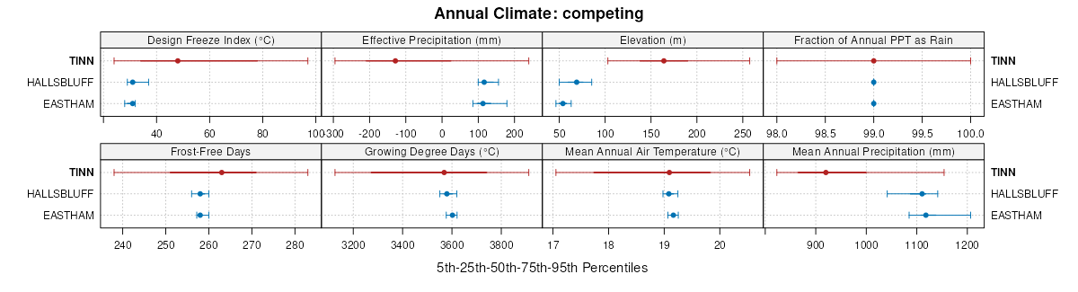
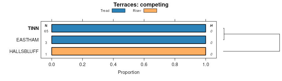
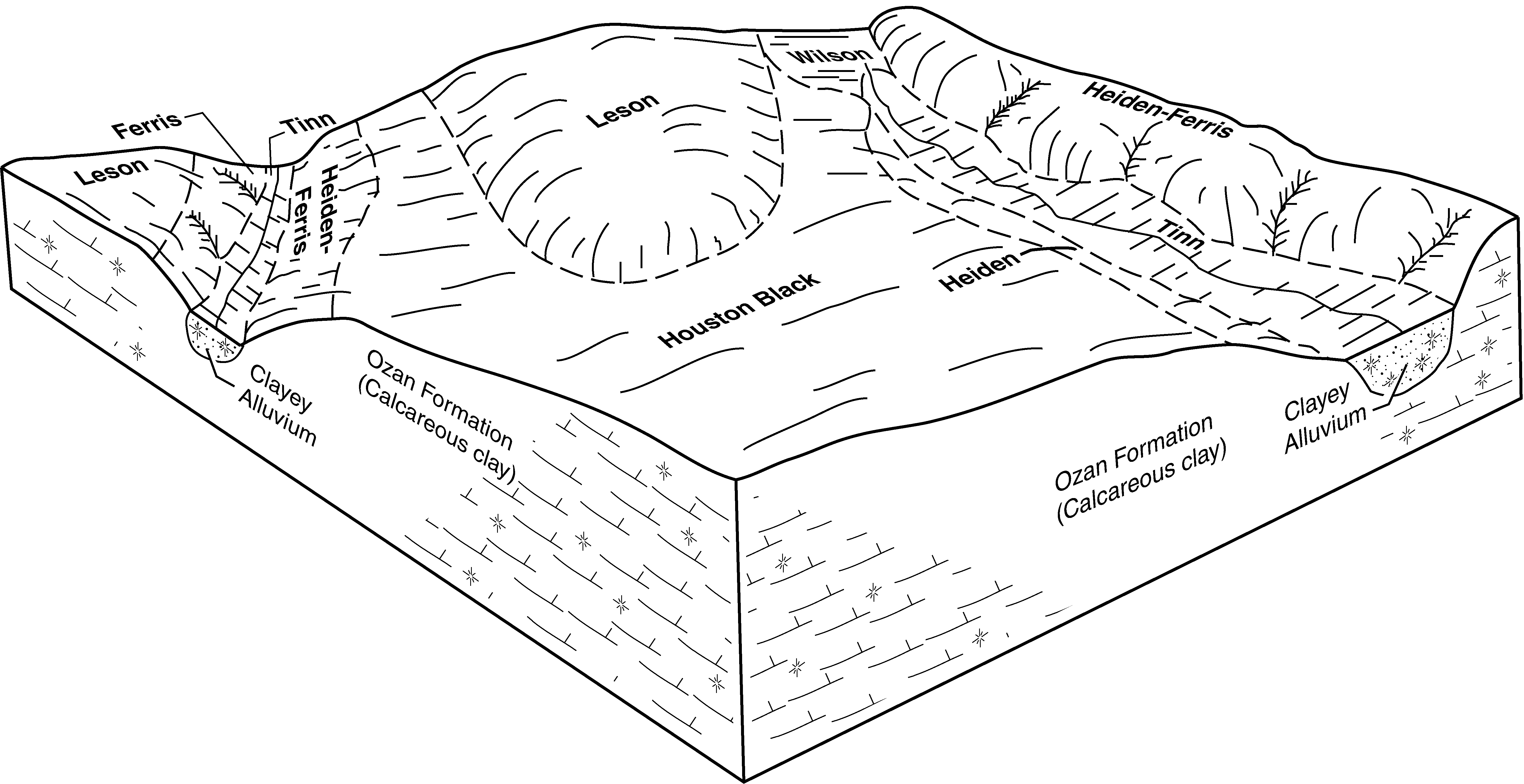
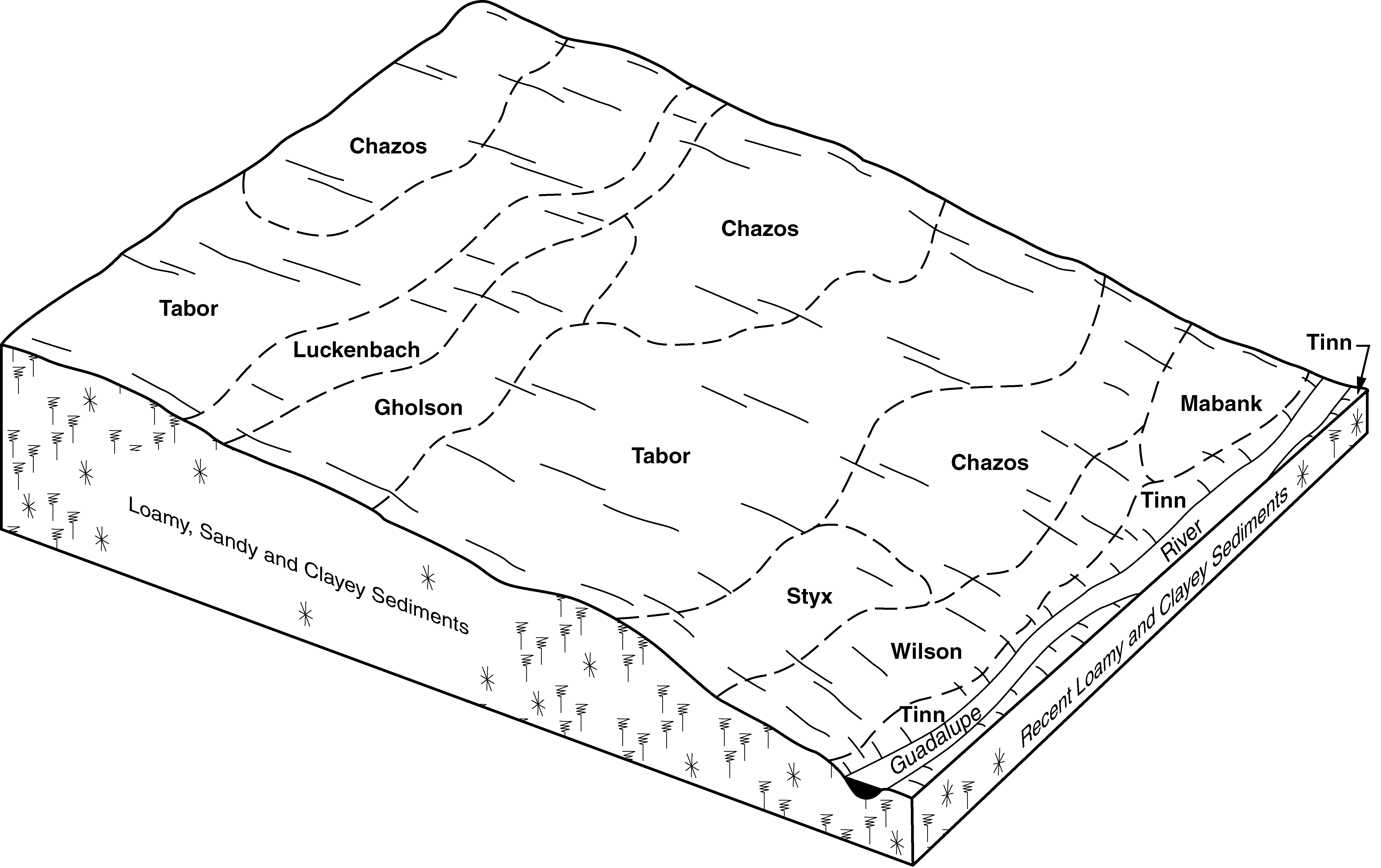
| Tinn clay, 0 to 1 percent slopes, occasionally flooded | 76 | 3286 | 381861 | 2sshf | ok013 | 1974 | 1:24000 |
Tinn-Roebuck complex, 0 to 1 percent slopes, occasionally flooded | Pr | 17878 | 571171 | m5bw | ok089 | 1970 | 1:24000 |
Tinn clay, 0 to 1 percent slopes, rarely flooded | Pg | 8838 | 571170 | m5bv | ok089 | 1970 | 1:24000 |
Tinn clay, 0 to 1 percent slopes, frequently flooded | Tw | 4129 | 393323 | 2vtgr | tx021 | 1972 | 1:24000 |
Tinn clay, 0 to 1 percent slopes, occasionally flooded | Tr | 981 | 393322 | 2sshf | tx021 | 1972 | 1:24000 |
Tinn clay, 0 to 1 percent slopes, frequently flooded | TnA | 21879 | 391134 | 2vtgr | tx027 | 1972 | 1:24000 |
Tinn clay, 0 to 1 percent slopes, occasionally flooded | TcA | 2973 | 391133 | 2sshf | tx027 | 1972 | 1:24000 |
Tinn and Frio soils, 0 to 1 percent slopes, frequently flooded | Tf | 20460 | 390507 | 2y0v4 | tx029 | 2000 | 1:24000 |
Tinn clay, 0 to 1 percent slopes, occasionally flooded | Tc | 3041 | 390506 | 2sshf | tx029 | 2000 | 1:24000 |
Tinn clay, 0 to 1 percent slopes, frequently flooded | Ts | 14091 | 363535 | 2vtgr | tx055 | 1972 | 1:20000 |
Tinn clay, 0 to 1 percent slopes, occasionally flooded | Tr | 5702 | 363534 | 2sshf | tx055 | 1972 | 1:20000 |
Tinn clay, 0 to 1 percent slopes, frequently flooded | Tf | 22086 | 364087 | 2vtgr | tx085 | 1965 | 1:20000 |
Tinn clay, 0 to 1 percent slopes, occasionally flooded | Te | 20263 | 3178137 | 2sshf | tx085 | 1965 | 1:20000 |
Tinn soils, 0 to 1 percent slopes, frequently flooded | 74 | 15083 | 364527 | d79y | tx097 | 1973 | 1:24000 |
Tinn clay, 0 to 1 percent slopes, rarely flooded | 73 | 13038 | 364526 | d79x | tx097 | 1973 | 1:24000 |
Tinn clay, 0 to 1 percent slopes, occasionally flooded | 81 | 348 | 3180436 | 2sshf | tx113 | 1975 | 1:20000 |
Tinn clay, 0 to 1 percent slopes, occasionally flooded | 87 | 2598 | 3180437 | 2sshf | tx121 | 1975 | 1:24000 |
Tinn clay, 0 to 1 percent slopes, frequently flooded | 79 | 2574 | 365034 | d7v9 | tx121 | 1975 | 1:24000 |
Tinn clay, 0 to 1 percent slopes, occasionally flooded | Ta | 577 | 3180431 | 2sshf | tx139 | 1962 | 1:20000 |
Tinn clay, 0 to 1 percent slopes, frequently flooded | 59 | 15674 | 365480 | 2vtgr | tx145 | 1975 | 1:20000 |
Tinn clay, 0 to 1 percent slopes, occasionally flooded | 58 | 2209 | 365479 | 2sshf | tx145 | 1975 | 1:20000 |
Tinn clay, 0 to 1 percent slopes, occasionally flooded | Tc | 13268 | 365551 | 2sshf | tx147 | 1989 | 1:24000 |
Tinn clay, 0 to 1 percent slopes, frequently flooded | Tf | 13057 | 365552 | 2vtgr | tx147 | 1989 | 1:24000 |
Tinn clay, 0 to 1 percent slopes, frequently flooded | ToA | 4008 | 366514 | 2vtgr | tx177 | 1997 | 1:24000 |
Bosque-Tinn complex, 0 to 1 percent slopes, frequently flooded | BpA | 1533 | 366490 | 2ylmd | tx177 | 1997 | 1:24000 |
Tinn clay, 0 to 1 percent slopes, occasionally flooded | TnA | 1149 | 366500 | 2sshf | tx177 | 1997 | 1:24000 |
Tinn clay, 0 to 1 percent slopes, occasionally flooded | 68 | 6251 | 366707 | 2sshf | tx181 | 1977 | 1:20000 |
Tinn clay, 0 to 1 percent slopes, frequently flooded | 82 | 217 | 3178140 | 2vtgr | tx181 | 1977 | 1:20000 |
Tinn clay, 0 to 1 percent slopes, frequently flooded | Tn | 10068 | 366821 | 2sshd | tx185 | 1988 | 1:24000 |
Tinn clay, 0 to 1 percent slopes, frequently flooded | Tw | 12634 | 366878 | 2vtgr | tx187 | 1973 | 1:20000 |
Tinn clay, 0 to 1 percent slopes, occasionally flooded | Tr | 6566 | 366877 | 2sshf | tx187 | 1973 | 1:20000 |
Tinn clay, 0 to 1 percent slopes, frequently flooded | 74 | 31225 | 367791 | 2vtgr | tx217 | 1975 | 1:20000 |
Tinn clay, 0 to 1 percent slopes, occasionally flooded | 73 | 7980 | 367790 | 2sshf | tx217 | 1975 | 1:20000 |
Tinn clay, 0 to 1 percent slopes, frequently flooded | 30 | 16086 | 367893 | 2vtgr | tx231 | 1978 | 1:24000 |
Tinn clay, 0 to 1 percent slopes, occasionally flooded | 29 | 2660 | 367891 | 2sshf | tx231 | 1978 | 1:24000 |
Tinn clay, 0 to 1 percent slopes, frequently flooded | Tn | 4264 | 368215 | 2vtgr | tx251 | 1981 | 1:20000 |
Tinn clay, 0 to 1 percent slopes, frequently flooded | To | 9972 | 369431 | 2vtgr | tx293 | 1991 | 1:24000 |
Tinn clay, 0 to 1 percent slopes, occasionally flooded | Tc | 2186 | 369430 | 2sshf | tx293 | 1991 | 1:24000 |
Tinn clay, 0 to 1 percent slopes, frequently flooded | To | 26209 | 370133 | 2vtgr | tx309 | 1992 | 1:24000 |
Tinn clay, 0 to 1 percent slopes, rarely flooded | Tn | 1942 | 370132 | 2y0tt | tx309 | 1992 | 1:24000 |
Tinn clay, 0 to 1 percent slopes, frequently flooded | TnA | 26464 | 370700 | 2vtgr | tx331 | 1988 | 1:24000 |
Tinn clay, 0 to 1 percent slopes, occasionally flooded | TcA | 18650 | 370699 | 2sshf | tx331 | 1988 | 1:24000 |
Tinn clay, 0 to 1 percent slopes, frequently flooded | Tm | 1712 | 3180433 | 2vtgr | tx349 | 1968 | 1:24000 |
Tinn clay, 0 to 1 percent slopes, occasionally flooded | Tk | 92 | 3180432 | 2sshf | tx349 | 1968 | 1:24000 |
Tinn clay, 0 to 1 percent slopes, occasionally flooded | Tn | 246 | 3178141 | 2sshf | tx387 | 1972 | 1:24000 |
Tinn clay, 0 to 1 percent slopes, frequently flooded | Tw | 16063 | 393252 | 2vtgr | tx453 | 1969 | 1:20000 |
Tinn clay, 0 to 1 percent slopes, occasionally flooded | Tv | 2566 | 393251 | 2sshf | tx453 | 1969 | 1:20000 |
Tinn clay, 0 to 1 percent slopes, frequently flooded | TnA | 16480 | 373575 | 2vtgr | tx491 | 1981 | 1:20000 |
Tinn clay, 0 to 1 percent slopes, occasionally flooded | TcA | 7160 | 373574 | 2sshf | tx491 | 1981 | 1:20000 |
Tinn clay, 0 to 1 percent slopes, frequently flooded | Tn | 6776 | 393653 | 2vtgr | tx604 | 1981 | 1:20000 |
Tinn clay, 0 to 1 percent slopes, frequently flooded | Td | 2061 | 3180435 | 2vtgr | tx612 | 1973 | 1:20000 |
Tinn clay, 0 to 1 percent slopes, occasionally flooded | Tc | 474 | 3180434 | 2sshf | tx612 | 1973 | 1:20000 |
Tinn clay, 0 to 1 percent slopes, occasionally flooded | 56 | 5434 | 3180440 | 2sshf | tx614 | 1975 | 1:20000 |
