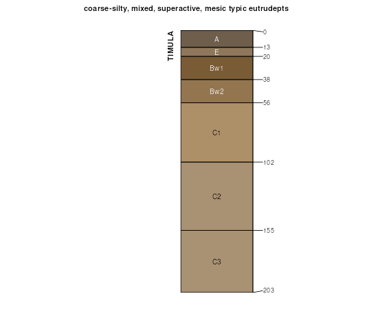
| Timula silt loam, 12 to 20 percent slopes, moderately eroded | 373E2 | 316 | 404412 | fktk | ia045 | 1978 | 1:15840 |
Timula silt loam, 5 to 14 percent slopes, moderately eroded | 673D2 | 635 | 408190 | fprf | ia105 | 1988 | 1:15840 |
Timula silt loam, 14 to 20 percent slopes, moderately eroded | 673E2 | 496 | 408191 | fprg | ia105 | 1988 | 1:15840 |
Timula silt loam, 14 to 18 percent slopes, severely eroded | 673E3 | 2276 | 411040 | fsqc | ia163 | 1989 | 1:15840 |
Timula silt loam, 9 to 14 percent slopes, severely eroded | 673D3 | 619 | 411038 | fsq9 | ia163 | 1989 | 1:15840 |
Timula silt loam, 18 to 25 percent slopes, severely eroded | 673F3 | 8 | 411042 | fsqf | ia163 | 1989 | 1:15840 |
Timula silt loam, 18 to 25 percent slopes, moderately eroded | 673F2 | 2266 | 411526 | ft71 | ia171 | 1989 | 1:15840 |
Timula silt loam, 14 to 18 percent slopes, severely eroded | 673E3 | 1943 | 411525 | ft70 | ia171 | 1989 | 1:15840 |
Timula silt loam, 14 to 18 percent slopes, moderately eroded | 673E2 | 1544 | 411524 | ft6z | ia171 | 1989 | 1:15840 |
Timula silt loam, 18 to 25 percent slopes, severely eroded | 673F3 | 1345 | 411527 | ft72 | ia171 | 1989 | 1:15840 |
Timula silt loam, 25 to 40 percent slopes | 673G | 572 | 411528 | ft73 | ia171 | 1989 | 1:15840 |
Timula silt loam, 9 to 14 percent slopes, moderately eroded | 673D2 | 197 | 411522 | ft6x | ia171 | 1989 | 1:15840 |
Timula silt loam, 9 to 14 percent slopes, severely eroded | 673D3 | 181 | 411523 | ft6y | ia171 | 1989 | 1:15840 |
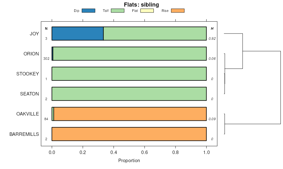
Stookey and Timula soils, 18 to 35 percent slopes | 856F | 3520 | 2378667 | 2kv66 | il001 | 1997 | 1:12000 |
Stookey-Timula-Orthents complex, 1 to 7 percent slopes | 816B | 2177 | 2378662 | 2kv61 | il001 | 1997 | 1:12000 |
Stookey and Timula soils, 35 to 60 percent slopes | 856G | 1402 | 2378668 | 2kv67 | il001 | 1997 | 1:12000 |
Timula silt loam, 10 to 18 percent slopes, eroded | 271D2 | 880 | 2378606 | 2kv47 | il001 | 1997 | 1:12000 |
Timula silt loam, 5 to 10 percent slopes, eroded | 271C2 | 683 | 2378605 | 2kv46 | il001 | 1997 | 1:12000 |
Stookey-Timula-Orthents complex, 7 to 15 percent slopes | 816D | 399 | 2378663 | 2kv62 | il001 | 1997 | 1:12000 |
Stookey and Timula soils, 35 to 60 percent slopes | 856G | 168 | 2542364 | 2qzkc | il013 | 1986 | 1:15840 |
Stookey and Timula soils, 18 to 35 percent slopes | 856F | 127 | 175506 | 5wmh | il013 | 1986 | 1:15840 |
Stookey and Timula soils, 18 to 25 percent slopes, eroded | 856E2 | 76 | 2518614 | 2qj62 | il013 | 1986 | 1:15840 |
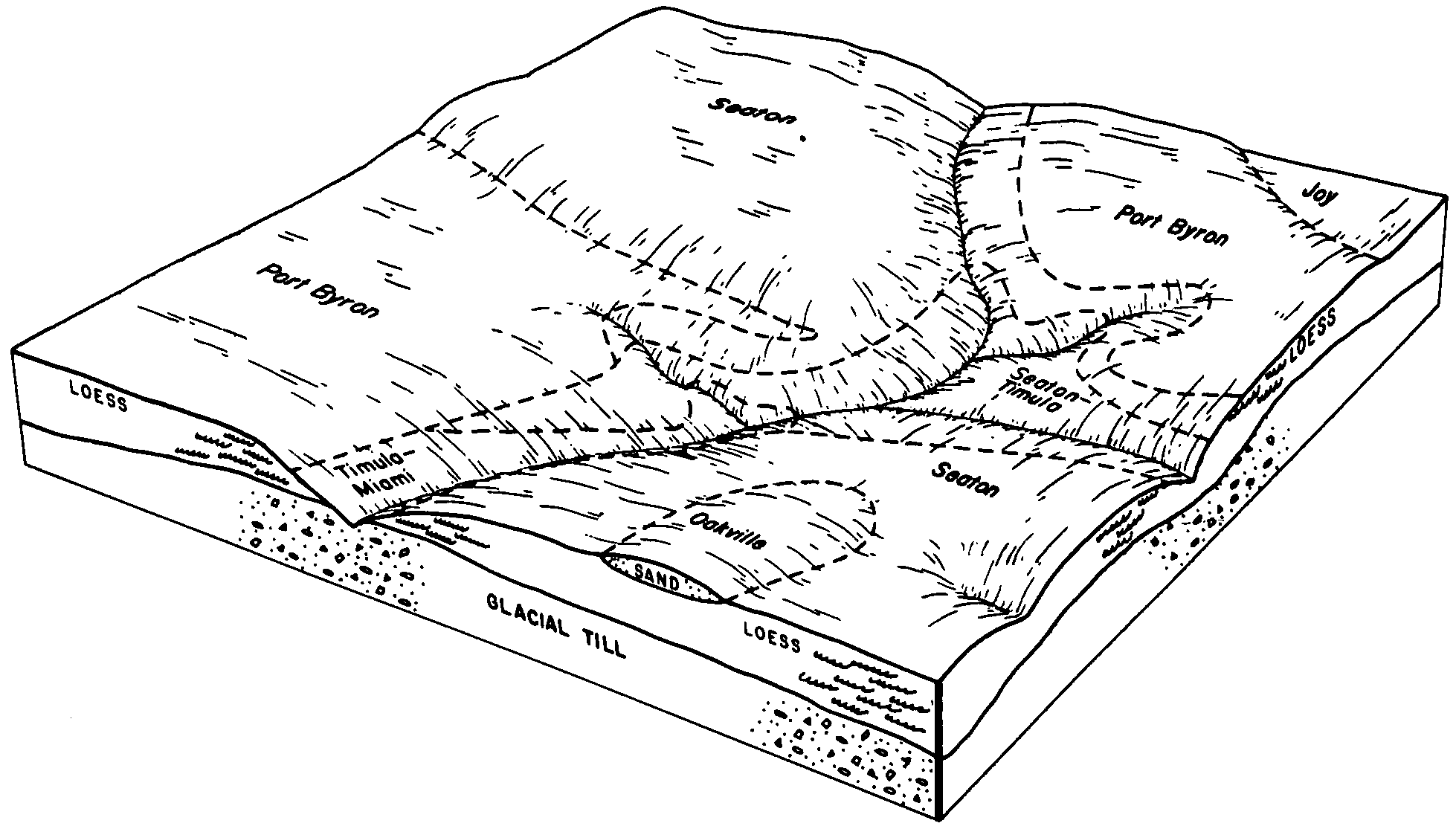
Seaton-Timula silt loams, 35 to 60 percent slopes, eroded | 943G2 | 4855 | 795945 | vq7n | il015 | 2005 | 1:12000 |
Seaton-Timula silt loams, 18 to 35 percent slopes, eroded | 943F2 | 528 | 1542731 | 1nsbj | il015 | 2005 | 1:12000 |
Seaton-Timula silt loams, 18 to 35 percent slopes | 943F | 5768 | 262824 | 8th6 | il017 | 2003 | 1:12000 |
Seaton-Timula silt loams, 35 to 60 percent slopes | 943G | 3529 | 262825 | 8th7 | il017 | 2003 | 1:12000 |
Timula silt loam, 10 to 18 percent slopes, eroded | 271D2 | 436 | 615649 | nnmn | il057 | 1997 | 1:12000 |
Seaton-Timula silt loams, 10 to 18 percent slopes, severely eroded | 943D3 | 2806 | 1395426 | 1hv1r | il071 | 2005 | 1:12000 |
Seaton-Timula silt loams, 35 to 60 percent slopes | 943G | 1219 | 1017813 | 1353p | il071 | 2005 | 1:12000 |
Seaton-Timula silt loams, 18 to 35 percent slopes, eroded | 943F2 | 1204 | 1017811 | 1353m | il071 | 2005 | 1:12000 |
Timula silt loam, 5 to 10 percent slopes, eroded | 271C2 | 718 | 1005954 | 12rs4 | il071 | 2005 | 1:12000 |
Timula silt loam, 10 to 18 percent slopes, eroded | 271D2 | 365 | 1005956 | 12rs6 | il071 | 2005 | 1:12000 |
Seaton-Timula silt loams, 10 to 18 percent slopes, severely eroded | 943D3 | 4106 | 244842 | 86s4 | il073 | 2001 | 1:12000 |
Seaton-Timula silt loams, 35 to 60 percent slopes | 943G | 3083 | 244843 | 86s5 | il073 | 2001 | 1:12000 |
Timula-Hickory silt loams, 35 to 60 percent slopes | 911G | 654 | 244832 | 86rt | il073 | 2001 | 1:12000 |
Timula silt loam, 10 to 18 percent slopes, eroded | 271D2 | 342 | 177775 | 5yzp | il125 | 1989 | 1:15840 |
Seaton-Timula silt loams, 10 to 18 percent slopes, severely eroded | 943D3 | 3211 | 245014 | 86yp | il131 | 2000 | 1:12000 |
Timula-Hickory silt loams, 35 to 60 percent slopes | 911G | 3024 | 200794 | 6qy7 | il131 | 2000 | 1:12000 |
Seaton-Timula silt loams, 35 to 60 percent slopes | 943G | 2512 | 245015 | 86yq | il131 | 2000 | 1:12000 |
Stookey and Timula soils, 18 to 25 percent slopes, eroded | 856E2 | 16230 | 201140 | 6r9d | il149 | 2001 | 1:12000 |
Stookey and Timula soils, 35 to 60 percent slopes | 856G | 9721 | 201284 | 6rg1 | il149 | 2001 | 1:12000 |
Timula silt loam, 5 to 10 percent slopes, severely eroded | 271C3 | 2382 | 200961 | 6r3m | il149 | 2001 | 1:12000 |
Timula silt loam, 10 to 18 percent slopes, severely eroded | 271D3 | 1124 | 201138 | 6r9b | il149 | 2001 | 1:12000 |
Stookey and Timula soils, 18 to 35 percent slopes | 856F | 288 | 201280 | 6rfx | il149 | 2001 | 1:12000 |
Seaton-Timula silt loams, 18 to 35 percent slopes, eroded | 943F2 | 2705 | 198762 | 6ntp | il161 | 2002 | 1:12000 |
Seaton-Timula silt loams, 10 to 18 percent slopes, eroded | 943D2 | 1913 | 185226 | 66r1 | il161 | 2002 | 1:12000 |
Timula silt loam, 10 to 18 percent slopes, eroded | 271D2 | 2 | 202218 | 6sf5 | il169 | 2000 | 1:12000 |
Seaton-Timula silt loams, 10 to 18 percent slopes, severely eroded | 943D3 | 344 | 244926 | 86vv | il187 | 2002 | 1:12000 |
Seaton-Timula silt loams, 10 to 18 percent slopes, severely eroded | 943D3 | 12058 | 793100 | vm8w | il195 | 2003 | 1:12000 |
Seaton-Timula silt loams, 18 to 35 percent slopes, eroded | 943F2 | 10063 | 793102 | vm8y | il195 | 2003 | 1:12000 |
Seaton-Timula silt loams, 18 to 25 percent slopes, severely eroded | 943E3 | 7439 | 793101 | vm8x | il195 | 2003 | 1:12000 |
Timula-Bold silt loams, 12 to 18 percent slopes, eroded | 963D2 | 832 | 396910 | fb0k | mn037 | 1980 | 1:15840 |
Timula-Bold silt loams, 6 to 12 percent slopes, eroded | 963C2 | 821 | 396909 | fb0j | mn037 | 1980 | 1:15840 |
Timula-Bold silt loams, 18 to 25 percent slopes, eroded | 963E2 | 606 | 396911 | fb0l | mn037 | 1980 | 1:15840 |
Timula-Mt. Carroll complex, 12 to 18 percent slopes, moderately eroded | N507D2 | 409 | 3053665 | 2wtrq | mn037 | 1980 | 1:15840 |
Timula-Mt. Carroll complex, 6 to 12 percent slopes, moderately eroded | N507C2 | 268 | 3053666 | 2wtrp | mn037 | 1980 | 1:15840 |
Timula-Mt. Carroll complex, 18 to 25 percent slopes | N507E | 212 | 3053667 | 2wtrr | mn037 | 1980 | 1:15840 |
Timula-Mt. Carroll complex, 6 to 12 percent slopes, moderately eroded | N507C2 | 17194 | 1711620 | 2wtrp | mn049 | 2007 | 1:12000 |
Timula-Mt. Carroll complex, 2 to 6 percent slopes | N507B | 12216 | 1711619 | 2wtrn | mn049 | 2007 | 1:12000 |
Timula-Mt. Carroll complex, 12 to 18 percent slopes, moderately eroded | N507D2 | 12127 | 1711621 | 2wtrq | mn049 | 2007 | 1:12000 |
Timula-Mt. Carroll complex, 18 to 25 percent slopes | N507E | 5483 | 1711622 | 2wtrr | mn049 | 2007 | 1:12000 |
Timula-Lamont complex, 20 to 40 percent slopes, moderately eroded | 1858F | 3056 | 398237 | 2wtrm | mn055 | 1981 | 1:15840 |
Timula silt loam, 6 to 12 percent slopes, moderately eroded | 322C2 | 6642 | 400761 | 2wtrf | mn109 | 1977 | 1:15840 |
Timula silt loam, 12 to 20 percent slopes, moderately eroded | 322D2 | 4776 | 400762 | 2wtrg | mn109 | 1977 | 1:15840 |
Timula-Bold complex, 6 to 12 percent slopes, eroded | 963C2 | 1191 | 429744 | gf5q | mn131 | 1996 | 1:12000 |
Timula-Bold complex, 12 to 18 percent slopes, eroded | 963D2 | 200 | 429746 | gf5s | mn131 | 1996 | 1:12000 |
Timula silt loam, 6 to 12 percent slopes, moderately eroded | 322C2 | 439 | 429036 | 2wtrf | mn169 | 1987 | 1:20000 |
Timula silt loam, 12 to 20 percent slopes, moderately eroded | 322D2 | 146 | 429037 | 2wtrg | mn169 | 1987 | 1:20000 |
Timula silt loam, 25 to 60 percent slopes | 10146 | 7891 | 902707 | z9bl | mo005 | 1988 | 1:24000 |
Timula-Hamburg silt loams, 30 to 90 percent slopes | 10148 | 2092 | 902708 | 31lxj | mo005 | 1988 | 1:24000 |
Timula-Hamburg silt loams, 14 to 90 percent slopes | 10147 | 344 | 2528238 | 31lxh | mo005 | 1988 | 1:24000 |
Timula silt loam, 14 to 25 percent slopes, severely eroded | 10156 | 82 | 2528253 | 2qmss | mo005 | 1988 | 1:24000 |
Timula-Knox silt loams, 14 to 35 percent slopes | 10149 | 6557 | 887535 | ysk5 | mo087 | 1992 | 1:24000 |
Timula silt loam, 9 to 14 percent slopes, severely eroded | 10158 | 5110 | 887505 | ysj6 | mo087 | 1992 | 1:24000 |
Timula-Hamburg silt loams, 14 to 90 percent slopes | 10147 | 4296 | 2528237 | 31lxh | mo087 | 1992 | 1:24000 |
Timula silt loam, 14 to 25 percent slopes, severely eroded | 10156 | 4022 | 2528254 | 2qmss | mo087 | 1992 | 1:24000 |
Timula silt loam, 2 to 7 percent slopes | 10157 | 259 | 902748 | z9cx | mo087 | 1992 | 1:24000 |
Timula silt loam, knolls, 20 to 40 percent slopes, moderately eroded | 110F2 | 460 | 2518479 | 2wtrl | wi063 | 2001 | 1:12000 |
Timula silt loam, knolls, 12 to 20 percent slopes, moderately eroded | 110D2 | 365 | 2518478 | 2wtrj | wi063 | 2001 | 1:12000 |