Official Series Description


Lab Data Summary

Aggregate lab data for the TILSIT soil series. This aggregation is based on all pedons with a current taxon name of TILSIT, and applied along 1-cm thick depth slices. Solid lines are the slice-wise median, bounded on either side by the interval defined by the slice-wise 5th and 95th percentiles. The median is the value that splits the data in half. Five percent of the data are less than the 5th percentile, and five percent of the data are greater than the 95th percentile. Values along the right hand side y-axis describe the proportion of pedon data that contribute to aggregate values at this depth. For example, a value of "90%" at 25cm means that 90% of the pedons correlated to TILSIT were used in the calculation. Source: KSSL snapshot . Methods used to assemble the KSSL snapshot used by SoilWeb / SDE

Click the image to view it full size.

Pedons used in the lab summary:

MLRALab IDPedon IDTaxonnameCINSSL / NASIS ReportsLink To SoilWeb GMap
114A92P0917S1992IN119001Tilsit7Primary | Supplementary | Taxonomy | Pedon | Water Retention | Correlation | Andic Soil Properties39.3388901,-86.9083328
114A92P0918S1992IN119002Tilsit7Primary | Supplementary | Taxonomy | Pedon | Water Retention | Correlation | Andic Soil Properties39.3391685,-86.9086075
120A40A4302S1963KY085001Tilsit5Primary | Supplementary | Taxonomy | Pedon | Water Retention | Correlation | Andic Soil Properties37.408763885498,-86.4875335693359
120BMT81011981IN101001Tilsit3Primary | Supplementary | Taxonomy | Pedon | Water Retention | Correlation | Andic Soil Properties38.6448639,-86.6964639
120CJN79101979IN071010Tilsit2Primary | Supplementary | Taxonomy | Pedon | Water Retention | Correlation | Andic Soil Properties39.0355028,-86.2636639
120CJN80151980IN071015Tilsit2Primary | Supplementary | Taxonomy | Pedon | Water Retention | Correlation | Andic Soil Properties39.0092778,-86.3044139
12298KY-111-00198KY111004Tilsit2Primary | Supplementary | Taxonomy | Pedon | Water Retention | Correlation | Andic Soil Properties38.085,-85.7905556
12469PA0190091969PA019009Tilsit5Primary | Supplementary | Taxonomy | Pedon | Water Retention | Correlation | Andic Soil Properties40.7283333,-79.8122222
12469PA0190101969PA019010Tilsit5Primary | Supplementary | Taxonomy | Pedon | Water Retention | Correlation | Andic Soil Properties40.7594444,-79.7794444
12458KY-205-00158KY-205-001Tilsit3Primary | Supplementary | Taxonomy | Pedon | Water Retention | Correlation | Andic Soil Properties38.2378311,-83.3390427
12510KY-125-00510KY125FSC005Tilsit1Primary | Supplementary | Taxonomy | Pedon | Water Retention | Correlation | Andic Soil Properties37.0583076,-84.1824417
12668PA0050071968PA005007Tilsit5Primary | Supplementary | Taxonomy | Pedon | Water Retention | Correlation | Andic Soil Properties40.67,-79.3233333
n/aMG-s031954-OH105-S03Tilsit4Primary | Supplementary | Taxonomy | Pedon | Water Retention | Correlation | Andic Soil Propertiesn/a
n/aCO-0701958-OH029-070Tilsit2Primary | Supplementary | Taxonomy | Pedon | Water Retention | Correlation | Andic Soil Propertiesn/a
n/aRO-0691959-OH141-069Tilsit4Primary | Supplementary | Taxonomy | Pedon | Water Retention | Correlation | Andic Soil Propertiesn/a
n/aCA-0091960-OH019-009Tilsit3Primary | Supplementary | Taxonomy | Pedon | Water Retention | Correlation | Andic Soil Propertiesn/a
n/aMN-0121960-OH111-012Tilsit2Primary | Supplementary | Taxonomy | Pedon | Water Retention | Correlation | Andic Soil Propertiesn/a
n/aMN-0131960-OH111-013Tilsit2Primary | Supplementary | Taxonomy | Pedon | Water Retention | Correlation | Andic Soil Propertiesn/a
n/aMN-0141960-OH111-014Tilsit2Primary | Supplementary | Taxonomy | Pedon | Water Retention | Correlation | Andic Soil Propertiesn/a
n/aGR-w031961-OH059-W03Tilsit2Primary | Supplementary | Taxonomy | Pedon | Water Retention | Correlation | Andic Soil Propertiesn/a
n/aMN-0201961-OH111-020Tilsit2Primary | Supplementary | Taxonomy | Pedon | Water Retention | Correlation | Andic Soil Propertiesn/a
n/aMN-w041961-OH111-W04Tilsit3Primary | Supplementary | Taxonomy | Pedon | Water Retention | Correlation | Andic Soil Propertiesn/a
n/aMO-0011961-OH115-001Tilsit2Primary | Supplementary | Taxonomy | Pedon | Water Retention | Correlation | Andic Soil Propertiesn/a
n/aMO-0041961-OH115-004Tilsit3Primary | Supplementary | Taxonomy | Pedon | Water Retention | Correlation | Andic Soil Propertiesn/a
n/aMO-0061961-OH115-006Tilsit3Primary | Supplementary | Taxonomy | Pedon | Water Retention | Correlation | Andic Soil Propertiesn/a
n/aMO-0091961-OH115-009Tilsit2Primary | Supplementary | Taxonomy | Pedon | Water Retention | Correlation | Andic Soil Propertiesn/a
n/aAD-s191962-OH001-S19Tilsit2Primary | Supplementary | Taxonomy | Pedon | Water Retention | Correlation | Andic Soil Propertiesn/a
n/aCS-w101962-OH031-W10Tilsit3Primary | Supplementary | Taxonomy | Pedon | Water Retention | Correlation | Andic Soil Propertiesn/a
n/aHL-w111962-OH075-W11Tilsit3Primary | Supplementary | Taxonomy | Pedon | Water Retention | Correlation | Andic Soil Propertiesn/a
n/aHL-w161962-OH075-W16Tilsit3Primary | Supplementary | Taxonomy | Pedon | Water Retention | Correlation | Andic Soil Propertiesn/a
n/aPR-W011962-OH127-W01Tilsit2Primary | Supplementary | Taxonomy | Pedon | Water Retention | Correlation | Andic Soil Propertiesn/a
n/aNB-S091965-OH121-S09Tilsit4Primary | Supplementary | Taxonomy | Pedon | Water Retention | Correlation | Andic Soil Propertiesn/a
n/aJK-0051977-OH079-005Tilsit4Primary | Supplementary | Taxonomy | Pedon | Water Retention | Correlation | Andic Soil Propertiesn/a
n/aHY-0681978-OH071-068Tilsit5Primary | Supplementary | Taxonomy | Pedon | Water Retention | Correlation | Andic Soil Propertiesn/a
n/aPK-0131982-OH131-013Tilsit4Primary | Supplementary | Taxonomy | Pedon | Water Retention | Correlation | Andic Soil Propertiesn/a
n/a54KY-011-00254KY-011-002Tilsit4Primary | Supplementary | Taxonomy | Pedon | Water Retention | Correlation | Andic Soil Propertiesn/a
n/a54KY-011-00354KY-011-003Tilsit4Primary | Supplementary | Taxonomy | Pedon | Water Retention | Correlation | Andic Soil Propertiesn/a
n/a55KY-205-00155KY-205-001Tilsit4Primary | Supplementary | Taxonomy | Pedon | Water Retention | Correlation | Andic Soil Propertiesn/a
n/a76KY-217-00876KY-217-008Tilsit4Primary | Supplementary | Taxonomy | Pedon | Water Retention | Correlation | Andic Soil Propertiesn/a
n/a79KY-173-00279KY-173-002Tilsit4Primary | Supplementary | Taxonomy | Pedon | Water Retention | Correlation | Andic Soil Propertiesn/a
n/a79KY-173-00879KY-173-008Tilsit3Primary | Supplementary | Taxonomy | Pedon | Water Retention | Correlation | Andic Soil Propertiesn/a
n/a83KY-155-00283KY-155-002Tilsit4Primary | Supplementary | Taxonomy | Pedon | Water Retention | Correlation | Andic Soil Propertiesn/a
n/a98KY-111-00298KY-111-002Tilsit2Primary | Supplementary | Taxonomy | Pedon | Water Retention | Correlation | Andic Soil Propertiesn/a
n/a40A5286S1955IN101001Tilsit3Primary | Supplementary | Taxonomy | Pedon | Water Retention | Correlation | Andic Soil Propertiesn/a
n/a40A4026S1958WV063013Tilsit5Primary | Supplementary | Taxonomy | Pedon | Water Retention | Correlation | Andic Soil Propertiesn/a
n/a40A4025S1958WV063014Tilsit5Primary | Supplementary | Taxonomy | Pedon | Water Retention | Correlation | Andic Soil Propertiesn/a
n/a40A4297S1963KY085008Tilsit6Primary | Supplementary | Taxonomy | Pedon | Water Retention | Correlation | Andic Soil Propertiesn/a
n/a40A5308S1973IN013001Tilsit6Primary | Supplementary | Taxonomy | Pedon | Water Retention | Correlation | Andic Soil Propertiesn/a
n/a40A5305S1973IN025003Tilsit7Primary | Supplementary | Taxonomy | Pedon | Water Retention | Correlation | Andic Soil Propertiesn/a
n/a40A5310S1973IN147002Tilsit6Primary | Supplementary | Taxonomy | Pedon | Water Retention | Correlation | Andic Soil Propertiesn/a
n/a40A4051S1973WV055011Tilsit3Primary | Supplementary | Taxonomy | Pedon | Water Retention | Correlation | Andic Soil Propertiesn/a

Water Balance

Monthly water balance estimated using a leaky-bucket style model for the TILSIT soil series. Monthly precipitation (PPT) and potential evapotranspiration (PET) have been estimated from the 50th percentile of gridded values (PRISM 1981-2010) overlapping with the extent of SSURGO map units containing each series as a major component. Monthly PET values were estimated using the method of Thornthwaite (1948). These (and other) climatic parameters are calculated with each SSURGO refresh and provided by the fetchOSD function of the soilDB package. Representative water storage values (“AWC” in the figures) were derived from SSURGO by taking the 50th percentile of profile-total water storage (sum[awc_r * horizon thickness]) for each soil series. Note that this representation of “water storage” is based on the average ability of most plants to extract soil water between 15 bar (“permanent wilting point”) and 1/3 bar (“field capacity”) matric potential. Soil moisture state can be roughly interpreted as “dry” when storage is depleted, “moist” when storage is between 0mm and AWC, and “wet” when there is a surplus. Clearly there are a lot of assumptions baked into this kind of monthly water balance. This is still a work in progress.

Click the image to view it full size.


Click the image to view it full size.

Sibling Summary

Siblings are those soil series that occur together in map units, in this case with the TILSIT series. Sketches are arranged according to their subgroup-level taxonomic structure. Source: SSURGO snapshot , parsed OSD records and snapshot of SC database .

Click the image to view it full size.

Select annual climate data summaries for the TILSIT series and siblings. Series are sorted according to hierarchical clustering of median values. Source: SSURGO map unit geometry and 1981-2010, 800m PRISM data .

Click the image to view it full size.

Geomorphic description summaries for the TILSIT series and siblings. Series are sorted according to hierarchical clustering of proportions and relative hydrologic position within an idealized landform (e.g. top to bottom). Most soil series (SSURGO components) are associated with a hillslope position and one or more landform-specific positions: hills, mountain slopes, terraces, and/or flats. Proportions can be interpreted as an aggregate representation of geomorphic membership. The values printed to the left (number of component records) and right (Shannon entropy) of stacked bars can be used to judge the reliability of trends. Small Shannon entropy values suggest relatively consistent geomorphic association, while larger values suggest lack thereof. Source: SSURGO component records .

Click the image to view it full size.

Click the image to view it full size.

Click the image to view it full size.

Click the image to view it full size.

Click the image to view it full size.

Competing Series

Soil series competing with TILSIT share the same family level classification in Soil Taxonomy. Source: parsed OSD records and snapshot of the SC database .

Click the image to view it full size.

Select annual climate data summaries for the TILSIT series and competing. Series are sorted according to hierarchical clustering of median values. Source: SSURGO map unit geometry and 1981-2010, 800m PRISM data .

Click the image to view it full size.

Geomorphic description summaries for the TILSIT series and competing. Series are sorted according to hierarchical clustering of proportions and relative hydrologic position within an idealized landform (e.g. top to bottom). Proportions can be interpreted as an aggregate representation of geomorphic membership. Most soil series (SSURGO components) are associated with a hillslope position and one or more landform-specific positions: hills, mountain slopes, terraces, and/or flats. The values printed to the left (number of component records) and right (Shannon entropy) of stacked bars can be used to judge the reliability of trends. Shannon entropy values close to 0 represent soil series with relatively consistent geomorphic association, while values close to 1 suggest lack thereof. Source: SSURGO component records .

Click the image to view it full size.

There are insufficient data to create the 3D hills figure.

There are insufficient data to create the 3D mountains figure.

Click the image to view it full size.

There are insufficient data to create the 3D flats position figure.

Soil series sharing subgroup-level classification with TILSIT, arranged according to family differentiae. Hovering over a series name will print full classification and a small sketch from the OSD. Source: snapshot of SC database .

Block Diagrams

Click a link below to display the diagram. Note that these diagrams may be from multiple survey areas.

  1. IN-2012-01-19-29 | Jackson County - October 1990

    Typical pattern of soils and parent material in the Berks-Gilpin-Wellston association (Soil Survey of Jackson County, Indiana; 1990).

  2. IN-2012-01-19-40 | Perry County - September 1969

    Relationship of relief and geologic strata to certain of the soil series represented in Perry County. The vertical scale is greatly exaggerated (Soil Survey of Perry County, Indiana; 1969).

  3. KY-2010-09-03-07 | Garrard and Lincoln Counties - 2006

    Typical pattern of soils and underlying material in the Trappist-Tilsit-Lenberg general soil map unit (Soil Survey of Garrard and Lincoln Counties, Kentucky; 2006).

  4. KY-2010-09-03-22 | Lewis County - 2004

    Typical pattern of soils and parent material in the Blairton-Berks-Brownsville general soil map unit (Soil Survey of Lewis County, Kentucky; 2004).

  5. KY-2010-09-03-23 | Lewis County - 2004

    Typical pattern of soils and parent material in the Berks-Brownsville-Blairton general soil map unit (Soil Survey of Lewis County, Kentucky; 2004).

  6. KY-2010-09-03-31 | Estill and Lee Counties - 2007

    Typical pattern of soils and their relationship to geology and topography in the Jessietown-Muse-Rohan general soil map unit in Estill County (Soil Survey of Estill and Lee Counties, Kentucky; 2007).

  7. KY-2012-01-26-17 | Bath County - September 1963

    Typical landscape in the knobby areas of the county showing the topography, the relationship of some of the principal soils, and the parent rocks (Soil Survey of Bath County, Kentucky; September 1963).

  8. KY-2012-01-26-25 | Bath County - September 1963

    Cross section of Bath County showing the major soils and their relationship to the rock formations and to relief (Soil Survey of Bath County, Kentucky; September 1963).

  9. KY-2012-01-27-07 | Caldwell County - September 1966

    Typical pattern of soils and underlying materials in association 1 (Soil Survey of Caldwell County, Kentucky; September 1966).

  10. KY-2012-01-27-09 | Caldwell County - September 1966

    Typical pattern of soils and underlying materials in association 3 (Soil Survey of Caldwell County, Kentucky; September 1966).

  11. KY-2012-01-27-43 | Clark County - 1964

    Major soil series in soil association 10, their relationship to the landscape, and the parent rocks from which the soils formed (Soil Survey of Clark County, Kentucky; 1964).

  12. KY-2012-01-27-74 | Fleming County - October 1993

    Typical pattern of soils and parent material in the Muse-Blairton-Brownsville soil map unit (Soil Survey of Fleming County, Kentucky; October 1993).

  13. KY-2012-01-30-15 | Hart County - May 1993

    Typical pattern of soils and underlying material in the Bledsoe-Wallen-Wellston general soil map unit (Soil Survey of Hart County, Kentucky; May 1993).

  14. KY-2012-01-30-21 | Hart County - May 1993

    Typical pattern of soils and underlying material in the Jefferson-Lily-Wellston general soil map unit (Soil Survey of Hart County, Kentucky; May 1993).

  15. KY-2012-02-01-11 | Marion County - August 1991

    Typical pattern of soils and parent material in the Trappist-Crider-Faywood general soil map unit (Soil Survey of Marion County, Kentucky; August 1991).

  16. KY-2012-02-01-27 | Menifee and Rowan Counties and Northwestern Morgan County - December 1974

    Pattern of soils and underlying material in the Tilsit-Clifty-Morehead association (Soil Survey of Menifee and Rowan Counties and Northwestern Morgan County, Kentucky; December 1974).

  17. KY-2012-02-01-31 | Menifee and Rowan Counties and Northwestern Morgan County - December 1974

    Pattern of soils and underlying material in the Latham-Tilsit-Johnsburg association (Soil Survey of Menifee and Rowan Counties and Northwestern Morgan County, Kentucky; December 1974).

  18. KY-2012-02-01-34 | Montgomery County - January 1986

    The pattern of soils and relationship to topography and underlying material in the Tilsit-Morehead-Tyler general soil map unit (Soil Survey of Montgomery County, Kentucky; January 1986).

  19. KY-2012-02-01-35 | Montgomery County - January 1986

    The pattern of soils and relationship to topography and underlying material in the Lenberg-Trappist-Colyer general soil map unit (Soil Survey of Montgomery County, Kentucky; January 1986).

  20. KY-2012-02-01-51 | Pulaski County - December 1974

    Pattern of soils and underlying material in association 9 (Soil Survey of Pulaski County, Kentucky; December 1974).

  21. OH-2012-02-16-40 | Scioto County - January 1989

    Typical pattern of soils and parent material in the Latham-Wharton-Shelocta association (Soil Survey of Scioto County, Ohio; January 1989).

  22. WV-2010-11-08-06 | Jackson and Mason Counties -

    The typical pattern of upland soils and parent materials that are dominant throughout the survey area (Soil Survey of Jackson and Mason Counties, West Virginia).

  23. WV-2010-11-08-07 | Jackson and Mason Counties -

    The dominant upland and high terrace soils in the Upper Flats area of northern Mason County. These high terrace soils have their origins associated with the ancient Teays River system (Soil Survey of Jackson and Mason Counties, West Virginia).

Map Units

Map units containing TILSIT as a major component. Limited to 250 records.

Map Unit Name Symbol Map Unit Area (ac) Map Unit Key National Map Unit Symbol Soil Survey Area Publication Date Map Scale
Tilsit (Wynnville) fine sandy loam, 2 to 6 percent slopes, erodedTtB2298343289512ykdnal04319601:20000
Tilsit (Wynnville) fine sandy loam, 2 to 6 percent slopesTtB143443289502ykdmal04319601:20000
Tilsit (Wynnville) loam, 0 to 2 percent slopesTsA8533289492ykdpal04319601:20000
Tilsit (Wynnville) silt loam, 5 to 10 percent slopes, erodedTh117813301812ykdqal07919501:20000
Tilsit (Wynnville) very fine sandy loam, 0 to 2 percent slopes, erodedTcB2111023307552ykdral09519561:20000
Tilsit (Wynnville) very fine sandy loam, 2 to 6 percent slopesTcB5553307542ykdsal09519561:20000
Tilsit (Wynnville) silt loam, 5 to 10 percent slopes, erodedTn52173311672ykdqal10319491:15840
Tilsit (Wynnville) silt loam, 0 to 2 percent slopesTp13843311692ykf8al10319491:15840
Tilsit (Wynnville) clay loam, 5 to 10 percent slopes, severely erodedTm2133311662ykdlal10319491:15840
Tilsit silt loam, 2 to 6 percent slopesTlB2738535607kzbnin01319851:15840
Tilsit silt loam, 0 to 2 percent slopesTlA947535656kzd7in03719781:15840
Tilsit silt loam, 0 to 2 percent slopesTlA783535566kz9bin10519791:15840
Tilsit silt loam, 2 to 6 percent slopes, erodedTsB266261600525cjzin14719661:15840
Tilsit silt loam, 0 to 2 percent slopesTsA11191600515cjyin14719661:15840
Tilsit silt loam, 2 to 6 percent slopes, severely erodedTsB39271600535ck0in14719661:15840
Tilsit silt loam, 2 to 6 percent slopes, erodedTtB235181599795cgmin17319761:15840
Tilsit silt loam, 0 to 2 percent slopesTtA4501599785cglin17319761:15840
Tilsit silt loam, 0 to 6 percent slopesTlB57617275321vzmvky01120061:12000
Tilsit silt loam, 6 to 12 percent slopes - residual landformsTlC8717275332t1m3ky01120061:12000
Tilsit silt loam, 2 to 6 percent slopes - residual & alluvial landformsTlB18325502652t1m1ky04319801:20000
Tilsit silt loam, 2 to 6 percent slopesTsB607550227lgk8ky04919621:15840
Tilsit silt loam, 2 to 6 percent slopes - residual landformsTsB27655527442t1m0ky06919891:20000
Tilsit silt loam, 6 to 12 percent slopes - residual landformsTsC4255527452t1m3ky06919891:20000
Tilsit silt loam, 12 to 25 percent slopesTjD202215330581ng8hky11120051:12000
Tilsit silt loam, 6 to 12 percent slopesTjC123515330571ng8gky11120051:12000
Urban land-Ultic Udarents-Tilsit complex, 0 to 12 percent slopesUamC71915330971ng9rky11120051:12000
Tilsit silt loam, 2 to 6 percent slopesTjB37515330561ng8fky11120051:12000
Tilsit silt loam, 2 to 6 percent slopes - residual landformsTsB16455503272t1m0ky13519981:20000
Tilsit silt loam, 6 to 12 percent slopes - residual landformsTsC1055503282t1m3ky13519981:20000
Tilsit-Berea silt loams, 2 to 6 percent slopesTbB7980552373ljshky15519861:20000
Tilsit-Berea silt loams, 6 to 12 percent slopes, erodedTbC2500552374ljsjky15519861:20000
Tilsit-Berea silt loams, 0 to 2 percent slopesTbA375552372ljsgky15519861:20000
Tilsit silt loam, 0 to 6 percent slopesTiB6177550545lgwjky17319831:20000
Tilsit silt loam, 6 to 12 percent slopesTiC628550546lgwkky17319831:20000
Tilsit silt loam, 2 to 6 percent slopesTlB3615550003lgb1ky17919671:15840
Tilsit silt loam, 6 to 12 percent slopes, erodedTlC2390550004lgb2ky17919671:15840
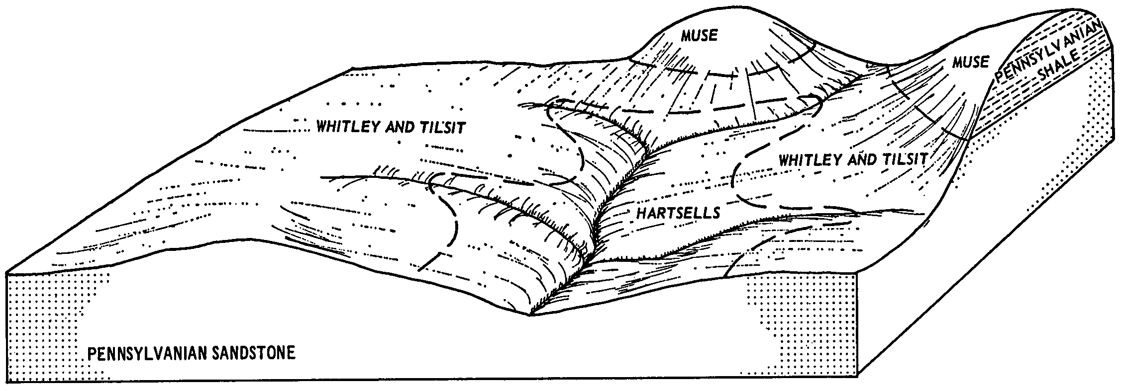
Whitley and Tilsit silt loams, 2 to 6 percent slopesWtB2944552478ljwwky19919691:12000
Tilsit silt loam, 2 to 6 percent slopes - residual & alluvial landformsTlB19045504272t1m1ky60519751:20000
Tilsit silt loam, 6 to 12 percent slopes - residual & alluvial landformsTlC6025504282t1m2ky60519751:20000
Tilsit silt loam, 2 to 6 percent slopesTlB1089551563lhycky60619791:20000
Tilsit silt loam, 0 to 2 percent slopesTlA729551562lhybky60619791:20000
Berea-Tilsit complex, 0 to 6 percent slopesBeB835557751lqczky61620041:24000
Tilsit silt loam, 2 to 6 percent slopesTlB5110552999lkfpky61819931:12000
Tilsit silt loam, 6 to 12 percent slopesTlC578553000lkfqky61819931:12000
Tilsit silt loam, 2 to 6 percent slopesTlB2707552305ljq9ky62819731:20000
Tilsit silt loam, 6 to 12 percent slopesTlC1659552306ljqbky62819731:20000
Wellston-Tilsit complex, 2 to 6 percent slopes79B154315423051nrwsky63019661:15840
Tilsit silt loam, 2 to 6 percent slopes78B18015418581nrfcky63019661:15840
Tilsit silt loam, 2 to 6 percent slopes - residual & alluvial landformsTlB862014788292t1m1ky64519711:20000
Tilsit silt loam, 6 to 12 percent slopes - residual & alluvial landformsTlC359014788302t1m2ky64519711:20000
Tilsit silt loam, 6 to 12 percent slopesTsC65124531072nbnhky64719891:20000
Tilsit silt loam, 2 to 6 percent slopesTsB16123794222kvzkky64820091:12000
Tilsit silt loam, 0 to 3 percent slopesTkA22771701242t1lxoh00119871:15840
Tilsit silt loam, 0 to 3 percent slopesTkA1814206942t1lxoh07119731:15840
Tilsit silt loam, 3 to 8 percent slopesTeB16515360482t1lyoh07919811:15840
Coolville-Tilsit silt loams, 2 to 6 percent slopesCtB814605071l0s4oh07919811:15840
Gilpin-Tilsit complex, 6 to 12 percent slopesGhC614605221l0smoh07919811:15840
Coolville-Tilsit silt loams, 2 to 6 percent slopesCtB1669536139kzwtoh08719891:15840
Tilsit silt loam, 0 to 3 percent slopesTkA69525377372t1lxoh13119841:15840
Gilpin-Tilsit complex, 6 to 12 percent slopesGtC4216890011tpjxoh13119841:15840
Gilpin-Tilsit complex, 6 to 12 percent slopesGhC16981708785qt6oh14119971:15840
Tilsit silt loam, 0 to 3 percent slopesTnA12601709712t1lxoh14119971:15840
Tilsit-Coolville association, undulatingTcB5029537319l13woh14519841:15840
Tilsit silt loam, 8 to 15 percent slopesTlC1432880872t1lzoh15119671:15840
Tilsit silt loam, 12 to 18 percent slopesTlD1152880889ns5oh15119671:15840
Tilsit silt loam, 3 to 8 percent slopesTeB55364322t1lyoh16319981:15840
Tilsit silt loam, 3 to 8 percent slopesTaB825417442t1lypa00319731:15840
Tilsit silt loam, 3 to 8 percent slopesTaB89524216482t1lypa00520121:24000
Tilsit silt loam, 0 to 3 percent slopesTaA31024216472t1lxpa00520121:24000
Tilsit silt loam, 8 to 15 percent slopesTaC9224217292t1lzpa00520121:24000
Tilsit silt loam, 3 to 8 percent slopesTsB572529003032t1lypa00719781:15840
Tilsit silt loam, 8 to 15 percent slopesTsC224729003042t1lzpa00719781:15840
Tilsit silt loam, 3 to 8 percent slopesTaB23628716082ps14pa00919891:24000
Tilsit silt loam, 3 to 8 percent slopesTaB85295382062t1lypa01919841:15840
Tilsit silt loam, 0 to 3 percent slopesTaA12875382052t1lxpa01919841:15840
Tilsit silt loam, 3 to 8 percent slopesTaB30924056282lr7xpa02719751:20000
Tilsit silt loam, 0 to 3 percent slopesTaA4024056272lr7wpa02719751:20000
Tilsit silt loam, 3 to 8 percent slopesTaB1687544110l85ypa03520021:24000
Tilsit silt loam, 0 to 3 percent slopesTaA1521544109l85xpa03520021:24000
Tilsit silt loam, 8 to 15 percent slopesTaC266544111l85zpa03520021:24000
Tilsit silt loam, 3 to 8 percent slopesTaB9028716192ps14pa06119741:20000
Tilsit silt loam, 8 to 15 percent slopesTsC2029004562t1lzpa07319781:15840
Tilsit silt loam, 3 to 8 percent slopesTsB529004552t1lypa07319781:15840
Tilsit silt loam, 3 to 8 percent slopesTtB574417167451vmdwwv06319621:24000
Tilsit silt loam, 8 to 15 percent slopesTtC384514574k8g5wv06319621:24000
Tilsit silt loam, 3 to 8 percent slopesTlB6355131862t1lywv07919811:20000
Monongahela and Tilsit silt loams, 10 to 20 percent slopesMnC4180513295k73xwv08519801:20000
Monongahela and Tilsit silt loams, 3 to 10 percent slopesMnB2765513294k73wwv08519801:20000
Monongahela and Tilsit silt loams, 10 to 20 percent slopes, severely erodedMnC3671513296k73ywv08519801:20000
Coolville and Tilsit soils, 3 to 8 percent slopesCsB1201813841841hgc3wv60020051:24000
Monongahela and Tilsit silt loams, 10 to 20 percent slopesMnC12456514619k8hmwv60119661:15840
Monongahela and Tilsit silt loams, 3 to 10 percent slopesMnB7124514618k8hlwv60119661:15840
Monongahela and Tilsit silt loams, 10 to 20 percent slopes, severely erodedMnC33958514620k8hnwv60119661:15840
Monongahela and Tilsit silt loams, 20 to 30 percent slopes, severely erodedMnD3190514622k8hqwv60119661:15840
Monongahela and Tilsit silt loams, 0 to 3 percent slopesMnA161514617k8hkwv60119661:15840
Monongahela and Tilsit silt loams, 20 to 30 percent slopesMnD135514621k8hpwv60119661:15840
Tilsit silt loam, 3 to 8 percent slopesTlB7355144012t1lywv61119771:20000
Tilsit silt loam, 8 to 15 percent slopesTlC5305144022t1lzwv61119771:20000
Tilsit silt loam, 3 to 8 percent slopesTsB13035151952t1lywv62419931:24000
Tilsit silt loam, 3 to 8 percent slopesTtB61932516602k9zhwv7131:24000
Tilsit silt loam, 8 to 15 percent slopesTtC19602516603k9zjwv7131:24000

Map of Series Extent

Approximate geographic distribution of the TILSIT soil series. To learn more about how this distribution was mapped, or to compare this soil series extent to others, use the Series Extent Explorer (SEE) application. Source: generalization of SSURGO geometry .