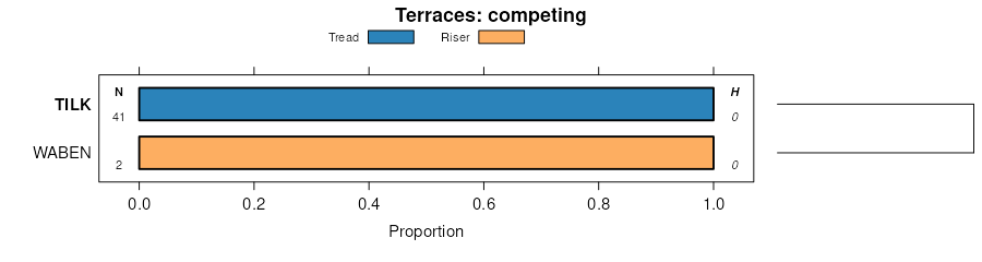
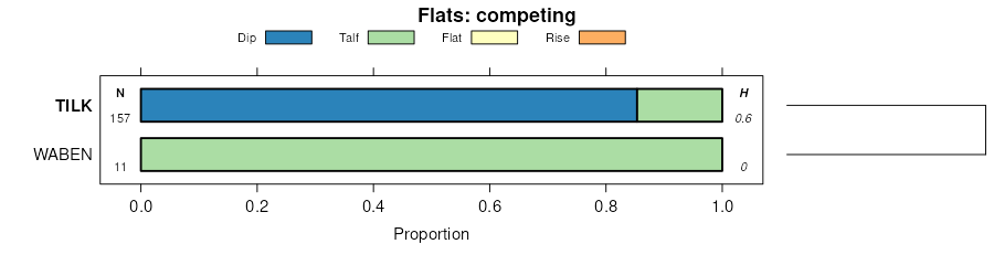
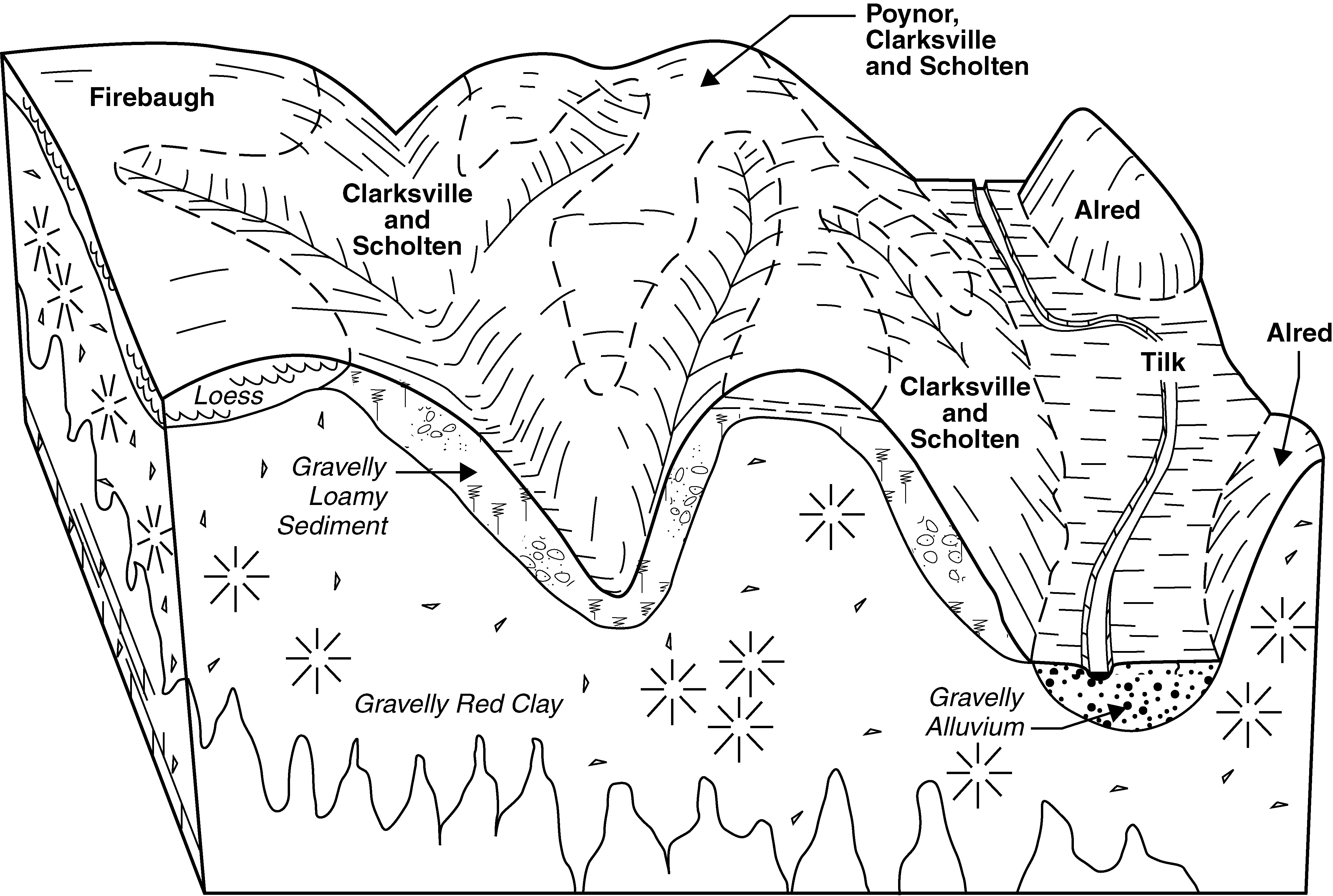
| Tilk-Secesh complex, 1 to 3 percent slopes, occasionally flooded | 76051 | 8339 | 2503489 | 2t7hj | mo017 | 2004 | 1:24000 |
Tilk-Secesh complex, 0 to 3 percent slopes, occasionally flooded | 75429 | 4436 | 2502808 | 2vxvf | mo017 | 2004 | 1:24000 |
Tilk, occasionally flooded-Cornwall-Poynor complex, 0 to 15 percent slopes | 75428 | 2158 | 2502802 | 2vxvd | mo017 | 2004 | 1:24000 |
Tilk very gravelly coarse sandy loam, 1 to 3 percent slopes, rarely flooded | 76050 | 434 | 2503480 | 2t7hf | mo017 | 2004 | 1:24000 |
Tilk very gravelly coarse sandy loam, 0 to 3 percent slopes, rarely flooded | 75411 | 225 | 2502770 | 2vxv8 | mo017 | 2004 | 1:24000 |
Tilk-Secesh complex, 1 to 3 percent slopes, occasionally flooded | 76051 | 224 | 2503492 | 2t7hj | mo023 | 1982 | 1:24000 |
Tilk-Secesh complex, 0 to 3 percent slopes, occasionally flooded | 75429 | 150 | 2502813 | 2vxvf | mo023 | 1982 | 1:24000 |
Tilk, occasionally flooded-Cornwall-Poynor complex, 0 to 15 percent slopes | 75428 | 16 | 2502806 | 2vxvd | mo023 | 1982 | 1:24000 |
Tilk very gravelly coarse sandy loam, 0 to 3 percent slopes, rarely flooded | 75411 | 1 | 2502778 | 2vxv8 | mo023 | 1982 | 1:24000 |
Tilk-Secesh complex, 0 to 3 percent slopes, occasionally flooded | 75429 | 17 | 2502814 | 2vxvf | mo031 | 1978 | 1:24000 |
Tilk-Secesh complex, 1 to 3 percent slopes, occasionally flooded | 76051 | 8 | 2503493 | 2t7hj | mo031 | 1978 | 1:24000 |
Tilk-Secesh complex, 1 to 3 percent slopes, occasionally flooded | 76051 | 16932 | 2503494 | 2t7hj | mo035 | 1988 | 1:24000 |
Tilk-Secesh complex, 0 to 3 percent slopes, occasionally flooded | 75429 | 8058 | 2502815 | 2vxvf | mo035 | 1988 | 1:24000 |
Tilk very gravelly coarse sandy loam, 0 to 3 percent slopes, rarely flooded | 75411 | 76 | 2502779 | 2vxv8 | mo035 | 1988 | 1:24000 |
Tilk, occasionally flooded-Cornwall-Poynor complex, 0 to 15 percent slopes | 75428 | 67 | 2502807 | 2vxvd | mo035 | 1988 | 1:24000 |
Tilk very gravelly coarse sandy loam, 1 to 3 percent slopes, rarely flooded | 76050 | 34 | 2503486 | 2t7hf | mo035 | 1988 | 1:24000 |
Tilk very gravelly coarse sandy loam, 1 to 3 percent slopes, rarely flooded | 76050 | 37 | 2503481 | 2t7hf | mo065 | 1971 | 1:24000 |
Tilk very gravelly coarse sandy loam, 0 to 3 percent slopes, rarely flooded | 75411 | 5 | 2502771 | 2vxv8 | mo065 | 1971 | 1:24000 |
Tilk very gravelly loam, 0 to 2 percent slopes, rarely flooded | 75418 | 3 | 2537489 | 2qq14 | mo065 | 1971 | 1:24000 |
Secesh-Tilk complex, 1 to 3 percent slopes, occasionally flooded | 76047 | 10437 | 2673095 | 2phpv | mo091 | 2004 | 1:24000 |
Secesh-Tilk complex, 0 to 2 percent slopes, occasionally flooded | 75420 | 6054 | 2537496 | 2qq16 | mo091 | 2004 | 1:24000 |
Tilk very gravelly loam, 1 to 3 percent slopes, rarely flooded | 76049 | 3452 | 2673096 | 2phnh | mo091 | 2004 | 1:24000 |
Tilk very gravelly loam, 0 to 2 percent slopes, rarely flooded | 75418 | 459 | 2537490 | 2qq14 | mo091 | 2004 | 1:24000 |
Tilk-Secesh complex, 1 to 3 percent slopes, occasionally flooded | 76051 | 441 | 2503490 | 2t7hj | mo093 | 1988 | 1:24000 |
Tilk-Secesh complex, 0 to 3 percent slopes, occasionally flooded | 75429 | 363 | 2502809 | 2vxvf | mo093 | 1988 | 1:24000 |
Tilk very gravelly coarse sandy loam, 1 to 3 percent slopes, rarely flooded | 76050 | 235 | 2503482 | 2t7hf | mo093 | 1988 | 1:24000 |
Tilk, occasionally flooded-Cornwall-Poynor complex, 0 to 15 percent slopes | 75428 | 136 | 2502803 | 2vxvd | mo093 | 1988 | 1:24000 |
Tilk very gravelly loam, 0 to 2 percent slopes, rarely flooded | 75418 | 107 | 2673109 | 2qq14 | mo105 | 1997 | 1:24000 |
Tilk very gravelly coarse sandy loam, 1 to 3 percent slopes, rarely flooded | 76050 | 11675 | 2503483 | 2t7hf | mo123 | 1999 | 1:24000 |
Tilk very gravelly coarse sandy loam, 0 to 3 percent slopes, rarely flooded | 75411 | 7554 | 2502773 | 2vxv8 | mo123 | 1999 | 1:24000 |
Tilk very gravelly loam, 1 to 3 percent slopes, rarely flooded | 76049 | 7731 | 2503479 | 2phnh | mo149 | 2004 | 1:24000 |
Secesh-Tilk complex, 1 to 3 percent slopes, occasionally flooded | 76047 | 5705 | 2503476 | 2phpv | mo149 | 2004 | 1:24000 |
Secesh-Tilk complex, 0 to 2 percent slopes, occasionally flooded | 75420 | 5461 | 2537499 | 2qq16 | mo149 | 2004 | 1:24000 |
Tilk very gravelly loam, 0 to 2 percent slopes, rarely flooded | 75418 | 709 | 2537492 | 2qq14 | mo149 | 2004 | 1:24000 |
Tilk very gravelly coarse sandy loam, 0 to 3 percent slopes, rarely flooded | 75411 | 150 | 2502774 | 2vxv8 | mo157 | 1983 | 1:24000 |
Tilk very gravelly coarse sandy loam, 1 to 3 percent slopes, rarely flooded | 76050 | 101 | 2508754 | 2t7hf | mo157 | 1983 | 1:24000 |
Tilk-Secesh complex, 1 to 3 percent slopes, occasionally flooded | 76051 | 4 | 2508756 | 2t7hj | mo157 | 1983 | 1:24000 |
Secesh-Tilk complex, 1 to 3 percent slopes, occasionally flooded | 76047 | 27 | 2673164 | 2phpv | mo169 | 1984 | 1:24000 |
Tilk very gravelly coarse sandy loam, 1 to 3 percent slopes, rarely flooded | 76050 | 9943 | 2503484 | 2t7hf | mo179 | 2004 | 1:24000 |
Tilk, occasionally flooded-Cornwall-Poynor complex, 0 to 15 percent slopes | 75428 | 7723 | 2502804 | 2vxvd | mo179 | 2004 | 1:24000 |
Tilk-Secesh complex, 0 to 3 percent slopes, occasionally flooded | 75429 | 4857 | 2502811 | 2vxvf | mo179 | 2004 | 1:24000 |
Tilk very gravelly coarse sandy loam, 0 to 3 percent slopes, rarely flooded | 75411 | 3902 | 2502775 | 2vxv8 | mo179 | 2004 | 1:24000 |
Tilk-Secesh complex, 1 to 3 percent slopes, occasionally flooded | 76051 | 3200 | 2503491 | 2t7hj | mo179 | 2004 | 1:24000 |
Tilk-Secesh complex, 1 to 3 percent slopes, occasionally flooded | 76051 | 910 | 2503495 | 2t7hj | mo181 | 1982 | 1:24000 |
Tilk-Secesh complex, 0 to 3 percent slopes, occasionally flooded | 75429 | 640 | 2502816 | 2vxvf | mo181 | 1982 | 1:24000 |
Tilk very gravelly loam, 1 to 3 percent slopes, rarely flooded | 76049 | 185 | 2487703 | 2phnh | mo181 | 1982 | 1:24000 |
Secesh-Tilk complex, 1 to 3 percent slopes, occasionally flooded | 76047 | 105 | 2503477 | 2phpv | mo181 | 1982 | 1:24000 |
Tilk very gravelly loam, 0 to 2 percent slopes, rarely flooded | 75418 | 13 | 2537488 | 2qq14 | mo181 | 1982 | 1:24000 |
Tilk very gravelly coarse sandy loam, 1 to 3 percent slopes, rarely flooded | 76050 | 3 | 2503487 | 2t7hf | mo181 | 1982 | 1:24000 |
Tilk very gravelly coarse sandy loam, 1 to 3 percent slopes, rarely flooded | 76050 | 7605 | 2503488 | 2t7hf | mo203 | 2004 | 1:24000 |
Secesh-Tilk complex, 1 to 3 percent slopes, occasionally flooded | 76047 | 1747 | 2487745 | 2phpv | mo203 | 2004 | 1:24000 |
Tilk very gravelly coarse sandy loam, 0 to 3 percent slopes, rarely flooded | 75411 | 1127 | 2502781 | 2vxv8 | mo203 | 2004 | 1:24000 |
Secesh-Tilk complex, 0 to 2 percent slopes, occasionally flooded | 75420 | 1074 | 2537495 | 2qq16 | mo203 | 2004 | 1:24000 |
Secesh-Tilk complex, 1 to 3 percent slopes, occasionally flooded | 76047 | 7245 | 2673182 | 2phpv | mo215 | 2002 | 1:24000 |
Secesh-Tilk complex, 0 to 2 percent slopes, occasionally flooded | 75420 | 6400 | 2537498 | 2qq16 | mo215 | 2002 | 1:24000 |
Tilk very gravelly loam, 0 to 2 percent slopes, rarely flooded | 75418 | 347 | 2537491 | 2qq14 | mo215 | 2002 | 1:24000 |
Tilk-Secesh complex, 1 to 3 percent slopes, occasionally flooded | 76051 | 21537 | 2487786 | 2t7hj | mo223 | 2004 | 1:24000 |
Tilk, occasionally flooded-Cornwall-Poynor complex, 0 to 15 percent slopes | 75428 | 19378 | 2502805 | 2vxvd | mo223 | 2004 | 1:24000 |
Tilk-Secesh complex, 0 to 3 percent slopes, occasionally flooded | 75429 | 15596 | 2502812 | 2vxvf | mo223 | 2004 | 1:24000 |
Tilk very gravelly coarse sandy loam, 0 to 3 percent slopes, rarely flooded | 75411 | 133 | 2502777 | 2vxv8 | mo223 | 2004 | 1:24000 |
Tilk very gravelly coarse sandy loam, 1 to 3 percent slopes, rarely flooded | 76050 | 106 | 2487782 | 2t7hf | mo223 | 2004 | 1:24000 |
