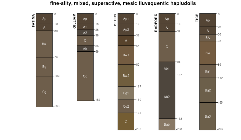
| Tice silty clay loam, 0 to 2 percent slopes, occasionally flooded | 8284A | 1283 | 2378693 | 2kv71 | il001 | 1997 | 1:12000 |
Tice silty clay loam, 0 to 2 percent slopes, frequently flooded, long duration | 3284L | 1659 | 602233 | 2tbrq | il003 | 2002 | 1:12000 |
Tice silty clay loam, 0 to 2 percent slopes, occasionally flooded | 8284A | 1229 | 602234 | n6nx | il003 | 2002 | 1:12000 |
Tice silty clay loam, occasionally flooded, brief duration | 284 | 692 | 173854 | 5tx6 | il005 | 1981 | 1:12000 |
Tice silty clay loam, 0 to 2 percent slopes, frequently flooded | 3284A | 1441 | 172969 | 5szn | il009 | 1984 | 1:12000 |
Tice silt loam, 0 to 2 percent slopes, frequently flooded, long duration | 3284L | 4126 | 2518940 | 2r21h | il013 | 1986 | 1:15840 |
Tice silt loam, 0 to 2 percent slopes, occasionally flooded | 8284A | 2674 | 2518944 | 2r21j | il013 | 1986 | 1:15840 |
Tice silt loam, 0 to 2 percent slopes, rarely flooded | 7284A | 845 | 2518618 | 2qr9c | il013 | 1986 | 1:15840 |
Tice silt loam, 0 to 2 percent slopes, frequently flooded | 3284A | 207 | 175515 | 5wms | il013 | 1986 | 1:15840 |
Tice silty clay loam, 0 to 2 percent slopes, frequently flooded, long duration | 3284L | 1488 | 262815 | 8tgx | il017 | 2003 | 1:12000 |
Tice silty clay loam, 0 to 2 percent slopes, rarely flooded | 7284A | 278 | 1445192 | 1khv3 | il017 | 2003 | 1:12000 |
Tice silty clay loam, 0 to 2 percent slopes, occasionally flooded | 8284A | 230 | 262839 | 8thp | il017 | 2003 | 1:12000 |
Tice silty clay loam, 0 to 2 percent slopes, frequently flooded | 3284A | 1839 | 261767 | 8sd3 | il021 | 1999 | 1:12000 |
Tice silty clay loam, 0 to 2 percent slopes, frequently flooded | 3284A | 1294 | 1452534 | 2yp4l | il023 | 2006 | 1:12000 |
Tice silty clay loam, 0 to 2 percent slopes, frequently flooded | 3284A | 518 | 1428418 | 1jyd0 | il029 | 2005 | 1:12000 |
Tice silty clay loam, 0 to 2 percent slopes, frequently flooded | 3284A | 475 | 200157 | 2yp4l | il033 | 2004 | 1:12000 |
Tice silty clay loam, 0 to 2 percent slopes, frequently flooded | 3284A | 725 | 174819 | 2yp4l | il035 | 1992 | 1:15840 |
Tice silty clay loam, 0 to 2 percent slopes, frequently flooded | 3284A | 2662 | 173395 | 2yp4l | il051 | 1991 | 1:15840 |
Tice silty clay loam, 0 to 2 percent slopes, frequently flooded | 3284A | 8817 | 615691 | nnp0 | il057 | 1997 | 1:12000 |
Tice silty clay loam, 0 to 2 percent slopes, occasionally flooded | 8284A | 3041 | 615702 | nnpc | il057 | 1997 | 1:12000 |
Tice silty clay loam, 0 to 2 percent slopes, frequently flooded | 3284A | 5704 | 211634 | 2yp4l | il059 | 1966 | 1:20000 |
Tice silty clay loam, 0 to 2 percent slopes, frequently flooded | 3284A | 1263 | 211751 | 73bp | il061 | 1968 | 1:15840 |
Tice silty clay loam 0 to 2 percent slopes, occasionally flooded | 8284A | 843 | 2542298 | 2qzh2 | il061 | 1968 | 1:15840 |
Tice silty clay loam, 0 to 2 percent slopes, frequently flooded, long duration | 3284L | 23 | 2542271 | 2qxsj | il061 | 1968 | 1:15840 |
Tice silt loam, 0 to 2 percent slopes, occasionally flooded | 8284A | 1970 | 175226 | 5wbg | il067 | 1993 | 1:15840 |
Tice silty clay loam, 0 to 2 percent slopes, frequently flooded | 3284A | 816 | 175179 | 5w8y | il067 | 1993 | 1:15840 |
Tice silt loam, 0 to 2 percent slopes, rarely flooded | 7284A | 1541 | 1018055 | 135ch | il071 | 2005 | 1:12000 |
Tice silty clay loam, 0 to 2 percent slopes, frequently flooded | 3284A | 79 | 1480515 | 1lplk | il071 | 2005 | 1:12000 |
Tice silty clay loam, 0 to 2 percent slopes, frequently flooded | 3284A | 1858 | 244850 | 86sd | il073 | 2001 | 1:12000 |
Tice silty clay loam, 0 to 2 percent slopes, occasionally flooded | 8284A | 579 | 244863 | 86st | il073 | 2001 | 1:12000 |
Tice silt loam, 0 to 2 percent slopes, frequently flooded | 3284A | 1200 | 175570 | 5wpk | il075 | 1980 | 1:15840 |
Tice silty clay loam, 0 to 2 percent slopes, occasionally flooded | 8284A | 1304 | 728434 | sfzw | il083 | 2002 | 1:12000 |
Tice silt loam, 0 to 2 percent slopes, occasionally flooded | 8284A | 2289 | 1949614 | 23fqs | il085 | 1990 | 1:12000 |
Tice silty clay loam, 0 to 2 percent slopes, frequently flooded | 3284A | 2911 | 176723 | 2yp4l | il101 | 1952 | 1:42240 |
Tice silty clay loam, sandy substratum, 0 to 2 percent slopes, frequently flooded | 3284AS | 4382 | 1596056 | 1qktp | il107 | 2006 | 1:12000 |
Tice silty clay loam, 0 to 2 percent slopes, frequently flooded | 3284A | 732 | 1596004 | 1qks0 | il107 | 2006 | 1:12000 |
Tice silty clay loam, 0 to 2 percent slopes, occasionally flooded | 8284A | 439 | 1596032 | 1qksx | il107 | 2006 | 1:12000 |
Tice silty clay loam, 0 to 2 percent slopes, frequently flooded | 3284A | 1795 | 634098 | p8ts | il109 | 2002 | 1:12000 |
Tice silty clay loam, 0 to 2 percent slopes, frequently flooded | 3284A | 1579 | 1913983 | 227nd | il115 | 2007 | 1:12000 |
Tice silty clay loam, 0 to 2 percent slopes, occasionally flooded | 8284A | 3599 | 198885 | 6nyn | il119 | 2001 | 1:12000 |
Tice-Fluvents-Urban land complex, 0 to 2 percent slopes, occasionally flooded | 2284A | 823 | 200835 | 6qzk | il119 | 2001 | 1:12000 |
Tice silty clay loam, 0 to 2 percent slopes, occasionally flooded | 8284A | 1269 | 177821 | 5z15 | il125 | 1989 | 1:15840 |
Tice silty clay loam, 0 to 2 percent slopes, frequently flooded | 3284A | 796 | 177787 | 5z02 | il125 | 1989 | 1:15840 |
Tice silty clay loam, sandy substratum, 0 to 2 percent slopes, frequently flooded | 3284AS | 644 | 2517983 | 2qhcb | il125 | 1989 | 1:15840 |
Tice silty clay loam, 0 to 2 percent slopes, frequently flooded | 3284A | 4411 | 638858 | pfsb | il129 | 2005 | 1:12000 |
Tice silty clay loam, sandy substratum, 0 to 2 percent slopes, frequently flooded | 3284AS | 2745 | 1408319 | 1j8gn | il129 | 2005 | 1:12000 |
Tice silty clay loam, 0 to 2 percent slopes, occasionally flooded | 8284A | 1844 | 1486749 | 1lx2n | il129 | 2005 | 1:12000 |
Tice silty clay loam, 0 to 2 percent slopes, occasionally flooded | 8284A | 705 | 184134 | 65lt | il133 | 1998 | 1:12000 |
Tice silt loam, 0 to 2 percent slopes, rarely flooded | 7284A | 429 | 1672144 | 1t404 | il137 | 1984 | 1:15840 |
Tice silty clay loam, 0 to 2 percent slopes, occasionally flooded | 8284A | 404 | 2542198 | 2qxpz | il137 | 1984 | 1:15840 |
Tice silty clay loam, 0 to 2 percent slopes, frequently flooded | 3284A | 785 | 246536 | 88js | il139 | 1999 | 1:12000 |
Tice silty clay loam, 0 to 2 percent slopes, frequently flooded | 3284A | 1123 | 1910906 | 224g4 | il147 | 2009 | 1:12000 |
Tice silty clay loam, 0 to 2 percent slopes, occasionally flooded | 8284A | 3142 | 201965 | 6s50 | il149 | 2001 | 1:12000 |
Tice silty clay loam, 0 to 2 percent slopes, occasionally flooded | 8284A | 98 | 749024 | t4f2 | il153 | 2004 | 1:12000 |
Tice silty clay loam, 0 to 2 percent slopes, frequently flooded | 3284A | 70 | 748952 | t4br | il153 | 2004 | 1:12000 |
Tice silty clay loam, 0 to 2 percent slopes, frequently flooded, long duration | 3284L | 11 | 748953 | t4bs | il153 | 2004 | 1:12000 |
Tice silty clay loam, 0 to 2 percent slopes, occasionally flooded | 8284A | 1422 | 200566 | 6qpw | il157 | 2001 | 1:12000 |
Tice silty clay loam, 0 to 2 percent slopes, occasionally flooded | 8284A | 39 | 183143 | 64kv | il163 | 1997 | 1:12000 |
Tice silty clay loam, 0 to 2 percent slopes, frequently flooded | 3284A | 10168 | 199373 | 6pgd | il167 | 1999 | 1:12000 |
Tice silty clay loam, 0 to 2 percent slopes, frequently flooded | 3284A | 6711 | 202230 | 6sfk | il169 | 2000 | 1:12000 |
Tice silty clay loam, 0 to 2 percent slopes, occasionally flooded | 8284A | 2449 | 202243 | 6sfz | il169 | 2000 | 1:12000 |
Tice silty clay loam, 0 to 2 percent slopes, occasionally flooded | 8284A | 2588 | 2542110 | 2qvgp | il171 | 1984 | 1:12000 |
Tice silty clay loam, 0 to 2 percent slopes, frequently flooded | 3284A | 958 | 179022 | 2yp4l | il173 | 1990 | 1:15840 |
Tice silt loam, 0 to 2 percent slopes, occasionally flooded | 8284A | 879 | 179429 | 60q1 | il179 | 1991 | 1:15840 |
Tice silt loam, 0 to 2 percent slopes, frequently flooded | 3284A | 802 | 2509779 | 2qgx8 | il179 | 1991 | 1:15840 |
Tice silty clay loam, 0 to 2 percent slopes, occasionally flooded | 8284A | 1034 | 199557 | 6pnb | il181 | 2001 | 1:12000 |
Tice silty clay loam, 0 to 2 percent slopes, frequently flooded | 3284A | 1054 | 179675 | 2yp4l | il185 | 1962 | 1:20000 |
Tice silty clay loam, 0 to 2 percent slopes, frequently flooded | TfsA | 3281 | 3380892 | 3128c | in001 | 1983 | 1:15840 |
Tice silty clay loam, 0 to 2 percent slopes, frequently flooded | TfsA | 11 | 2567885 | 3128c | in075 | 1983 | 1:15840 |
Tice silty clay loam, frequently flooded | Tg | 860 | 164325 | 5hzt | in157 | 1990 | 1:15840 |
Dockery and Tice silt loams, 0 to 2 percent slopes, occasionally flooded | 66081 | 15912 | 2533748 | 2qp9k | mo001 | 1992 | 1:24000 |
Dockery and Tice silt loams, 1 to 3 percent slopes, frequently flooded | 66136 | 516 | 2544629 | 2qs38 | mo001 | 1992 | 1:24000 |
Tice silt loam, 0 to 2 percent slopes, frequently flooded | 36037 | 19003 | 2532163 | 2qnvy | mo041 | 1992 | 1:24000 |
Tice silty clay loam, 0 to 2 percent slopes, rarely flooded | 66108 | 2538 | 888498 | ytk7 | mo041 | 1992 | 1:24000 |
Tice silt loam, overwash, 0 to 2 percent slopes, frequently flooded | 36038 | 1002 | 2532167 | 2qnvz | mo079 | 1988 | 1:24000 |
Tice silt loam, 1 to 4 percent slopes, frequently flooded | 36090 | 22 | 2544580 | 2qs2h | mo079 | 1988 | 1:24000 |
Tice silty clay loam, 0 to 2 percent slopes, frequently flooded, long duration | 66050 | 1159 | 2533662 | 2tbrq | mo099 | 2000 | 1:24000 |
Dockery and Tice silt loams, 0 to 2 percent slopes, occasionally flooded | 66081 | 89 | 2533747 | 2qp9k | mo103 | 1973 | 1:24000 |
Tice silt loam, 0 to 2 percent slopes, occasionally flooded | 66107 | 432 | 2533784 | 2qp9x | mo113 | 1985 | 1:24000 |
Tice silt loam, 0 to 2 percent slopes, frequently flooded | 36037 | 15 | 2532165 | 2qnvy | mo115 | 1987 | 1:24000 |
Tice silt loam, overwash, 0 to 2 percent slopes, frequently flooded | 36038 | 9319 | 2532168 | 2qnvz | mo117 | 1996 | 1:24000 |
Tice silty clay, 0 to 2 percent slopes, overwash, occasionally flooded | 36039 | 2771 | 888192 | yt7c | mo117 | 1996 | 1:24000 |
Tice silty clay loam, 0 to 2 percent slopes, frequently flooded, long duration | 66050 | 7211 | 2533663 | 2tbrq | mo121 | 1991 | 1:24000 |
Tice silty clay loam, 1 to 3 percent slopes, frequently flooded | 66134 | 2020 | 2544626 | 2qs36 | mo121 | 1991 | 1:24000 |
Dockery and Tice silt loams, 0 to 2 percent slopes, occasionally flooded | 66081 | 384 | 2533749 | 2qp9k | mo121 | 1991 | 1:24000 |
Dockery and Tice silt loams, 1 to 3 percent slopes, frequently flooded | 66136 | 35 | 2544628 | 2qs38 | mo121 | 1991 | 1:24000 |
Tice silt loam, 0 to 2 percent slopes, occasionally flooded | 66107 | 6765 | 2533783 | 2qp9x | mo163 | 1991 | 1:24000 |
Tice silt loam,1 to 3 percent slopes, frequentlylly flooded | 67080 | 877 | 2575463 | 2r0cn | mo163 | 1991 | 1:24000 |
Tice silt loam, 0 to 2 percent slopes, frequently flooded | 36037 | 10 | 2532166 | 2qnvy | mo175 | 1986 | 1:24000 |
Tice silt loam, 0 to 2 percent slopes, frequently flooded | 36037 | 4470 | 2532162 | 2qnvy | mo211 | 1990 | 1:24000 |
Tice silt loam, 1 to 4 percent slopes, frequently flooded | 36090 | 835 | 2544581 | 2qs2h | mo211 | 1990 | 1:24000 |
Tice silty clay loam, 0 to 2 percent slopes, frequently flooded | Tic3AF | 5 | 2567889 | 3128c | oh161 | 1967 | 1:15840 |
