| Theon-Singatse association | 1051 | 26 | 2439163 | 2tfnh | nv602 | 1985 | 1:24000 |
Pirouette-Theon-Weena association | 7004 | 10871 | 2427738 | 2mh84 | nv603 | 1971 | 1:24000 |
Piroutte-Theon association | 7061 | 5578 | 2427777 | 2mh9d | nv603 | 1971 | 1:24000 |
Pirouette-Theon-Celeton association | 7039 | 5045 | 2427765 | 2mh90 | nv603 | 1971 | 1:24000 |
Theon-Singatse-Weena association | 7036 | 3701 | 2427762 | 2mh8x | nv603 | 1971 | 1:24000 |
Theon-Ceejay-Rock outcrop association | 7008 | 962 | 2427737 | 2mh83 | nv603 | 1971 | 1:24000 |
Theon-Ceejay-Weena association | 7037 | 437 | 2427763 | 2mh8y | nv603 | 1971 | 1:24000 |
Theon very gravelly sandy loam, 8 to 30 percent slopes | 241 | 102 | 2399538 | 2v42f | nv603 | 1971 | 1:24000 |
Theon very gravelly sandy loam, 8 to 30 percent slopes | 651 | 63486 | 474024 | 2v42f | nv625 | 1981 | 1:24000 |
Theon-Olac association | 652 | 41309 | 474025 | 2w36l | nv625 | 1981 | 1:24000 |
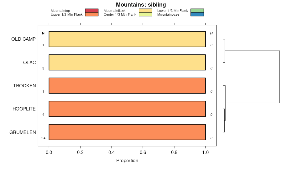
Theon-Rock outcrop-Old Camp, 50 to 75 percent slopes | 654 | 19886 | 474027 | hx86 | nv625 | 1981 | 1:24000 |
Singatse-Theon association | 633 | 16921 | 474019 | hx7y | nv625 | 1981 | 1:24000 |
Theon-Lapon-Olac association | 653 | 16809 | 474026 | hx85 | nv625 | 1981 | 1:24000 |
Theon-Singatse-Hawsley association | 7202 | 5130 | 2425580 | 2tfnl | nv625 | 1981 | 1:24000 |
Piroutte-Theon-Weena association | 7004 | 4991 | 2425550 | 2mdzk | nv625 | 1981 | 1:24000 |
Theon-Ceejay-Weena association | 7037 | 4356 | 2452819 | 2nbc6 | nv625 | 1981 | 1:24000 |
Theon-Singatse-Rock outcrop association | 7005 | 2600 | 2425530 | 2tfn8 | nv625 | 1981 | 1:24000 |
Theon-Singatse-Weena association | 7036 | 1899 | 2452818 | 2nbc5 | nv625 | 1981 | 1:24000 |
Theon-Yerington association | 655 | 1205 | 474028 | hx87 | nv625 | 1981 | 1:24000 |
Pirouette-Theon-Celeton association | 7039 | 793 | 2452821 | 2nbc8 | nv625 | 1981 | 1:24000 |
Theon-Singatse association | 1606 | 1825 | 474449 | 2tfnh | nv628 | 1980 | 1:24000 |
Pirouette-Theon-Weena association | 7004 | 50 | 2452474 | 2nb02 | nv628 | 1980 | 1:24000 |
Theon-Singatse association | 1051 | 46652 | 476217 | 2tfnh | nv761 | 1988 | 1:24000 |
Theon-Old Camp association, cobbly | 1055 | 32591 | 476222 | hzk0 | nv761 | 1988 | 1:24000 |
Theon-Grumblen-Rubble land association | 1052 | 31357 | 476218 | hzjw | nv761 | 1988 | 1:24000 |
Theon-Pickup association | 1056 | 24435 | 476223 | hzk1 | nv761 | 1988 | 1:24000 |
Pickup-Old Camp-Theon association | 752 | 7478 | 476350 | hzp4 | nv761 | 1988 | 1:24000 |
Theon-Rock outcrop association | 1053 | 2527 | 476219 | hzjx | nv761 | 1988 | 1:24000 |
Theon-Old Camp association | 1054 | 2169 | 476221 | 2tfnk | nv761 | 1988 | 1:24000 |
Theon-Singatse association, cobbly | 1050 | 1939 | 476216 | hzjt | nv761 | 1988 | 1:24000 |
Theon-Singatse association | 191 | 31028 | 475240 | 2tfnh | nv769 | 1986 | 1:24000 |
Theon-Singatse-Rock outcrop association | 190 | 25355 | 475239 | 2tfn8 | nv769 | 1986 | 1:24000 |
Theon-Singatse-Rock outcrop association | 191 | 82575 | 476476 | 2tfn8 | nv770 | 1995 | 1:24000 |
Singatse-Theon-Rezave association | 162 | 27528 | 476457 | hzsl | nv770 | 1995 | 1:24000 |
Theon-Mirkwood-Rock outcrop association | 193 | 21096 | 476478 | hzt8 | nv770 | 1995 | 1:24000 |
Theon-Old Camp association | 190 | 16029 | 476475 | 2tfnk | nv770 | 1995 | 1:24000 |
Piroutte-Theon-Weena association | 7004 | 14967 | 2229396 | 2dtw0 | nv770 | 1995 | 1:24000 |
Hooplite-Theon-Old Camp association | 730 | 12395 | 476654 | hzzy | nv770 | 1995 | 1:24000 |
Theon association | 1102 | 11831 | 476403 | 2tfnq | nv770 | 1995 | 1:24000 |
Hawsley-Theon-Pirouette association | 144 | 7337 | 476442 | hzs3 | nv770 | 1995 | 1:24000 |
Pirouette-Theon association | 7061 | 6014 | 2452500 | 2nb0x | nv770 | 1995 | 1:24000 |
Olac-Theon-Pirouette association | 1061 | 4154 | 476394 | hzqk | nv770 | 1995 | 1:24000 |
Pirouette-Theon-Rubble land association | 208 | 3951 | 476492 | hztq | nv770 | 1995 | 1:24000 |
Theon-Hooplite-Singatse association | 194 | 3717 | 476479 | hzt9 | nv770 | 1995 | 1:24000 |
Theon-Roic-Singatse association | 1104 | 3591 | 476404 | hzqw | nv770 | 1995 | 1:24000 |
Theon-Olac-Singatse association | 199 | 3516 | 476484 | hztg | nv770 | 1995 | 1:24000 |
Theon-Olac association | 1100 | 2548 | 476401 | 2w36l | nv770 | 1995 | 1:24000 |
Hooplite-Theon-Puett association | 734 | 2397 | 476658 | j002 | nv770 | 1995 | 1:24000 |
Theon association, steep | 1101 | 2074 | 476402 | hzqt | nv770 | 1995 | 1:24000 |
Theon very gravelly sandy loam, 8 to 30 percent slopes | 192 | 1605 | 476477 | 2v42f | nv770 | 1995 | 1:24000 |
Theon-Trocken-Singatse association | 1373 | 7195 | 477355 | j0qk | nv771 | 1990 | 1:24000 |
Old Camp-Reywat-Theon association | 258 | 7148 | 477433 | j0t2 | nv771 | 1990 | 1:24000 |
Jaybee-Theon-Singatse association | 1320 | 6762 | 477342 | j0q4 | nv771 | 1990 | 1:24000 |
Theon-Jaybee association | 1370 | 3954 | 477353 | j0qh | nv771 | 1990 | 1:24000 |
Rezave-Theon association | 441 | 2631 | 477487 | j0vt | nv771 | 1990 | 1:24000 |
Theon-Old Camp association | 1372 | 2112 | 477354 | 2tfnk | nv771 | 1990 | 1:24000 |
Theon-Ceejay-Rock outcrop association | 7008 | 3680 | 2452467 | 2n9zv | nv772 | 1985 | 1:24000 |
Theon-Old Camp association | 213 | 2660 | 479359 | 2tfnk | nv772 | 1985 | 1:24000 |
Theon very gravelly loam, 15 to 50 percent slopes | 912 | 2675 | 644193 | pmbf | nv773 | 1981 | 1:24000 |
Theon very gravelly sandy loam, 8 to 30 percent slopes | 911 | 524 | 644192 | 2v42f | nv773 | 1981 | 1:24000 |
Theon-Singatse-Rock outcrop association | 7005 | 32561 | 2425531 | 2tfn8 | nv774 | 1985 | 1:24000 |
Theon-Singatse-Hawsley association | 7202 | 8835 | 2425607 | 2tfnl | nv774 | 1985 | 1:24000 |
Theon-Old Camp association | 1121 | 7362 | 476712 | 2tfnk | nv774 | 1985 | 1:24000 |
Singatse-Theon- Rock outcrop association | 1090 | 5331 | 476709 | 2xdmq | nv774 | 1985 | 1:24000 |
Downeyville-Theon-Nemico association | 7074 | 1406 | 2425589 | 2mf0t | nv774 | 1985 | 1:24000 |
Theon very gravelly sandy loam, 8 to 30 percent slopes | 1127 | 159 | 476713 | 2v42f | nv774 | 1985 | 1:24000 |
Theon very cobbly loam, 15 to 50 percent slopes | 1110 | 179 | 475408 | hypr | nv777 | 1993 | 1:24000 |
Singatse-Theon- Rock outcrop association | 1071 | 1185 | 480675 | 2xdmq | nv781 | 1994 | 1:24000 |
Hooplite-Theon-Old Camp association | 1790 | 128 | 480811 | j4b1 | nv781 | 1994 | 1:24000 |
Checkett-Theon families association, 2 to 40 percent slopes | 11 | 84285 | 3183835 | 2whr3 | ut617 | | 1:24000 |
Theon family-Rock outcrop complex, 3 to 40 percent slopes | 81 | 12819 | 3183910 | 2x4h8 | ut617 | | 1:24000 |


