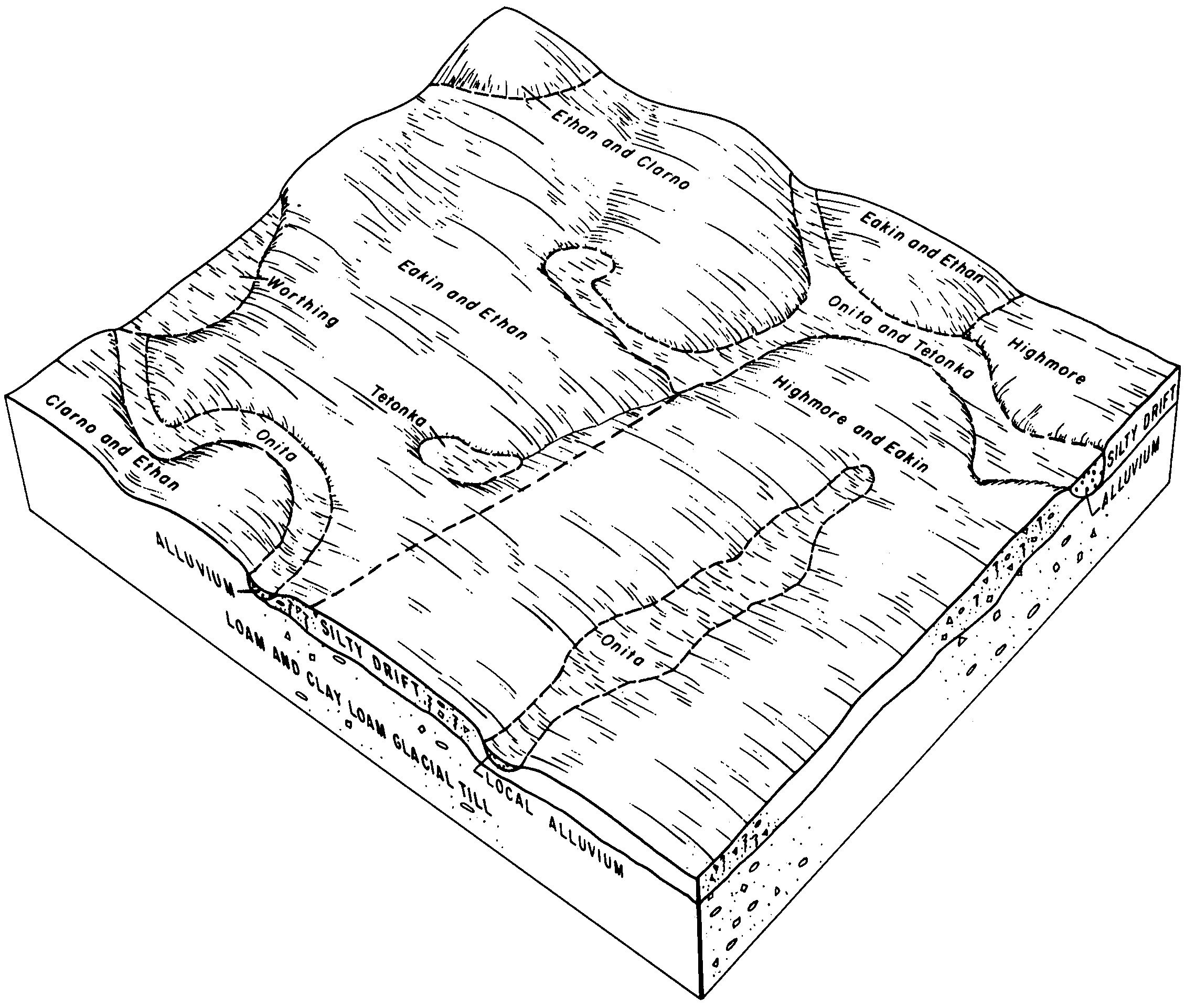
| Tetonka silt loam, 0 to 1 percent slopes | Te | 5418 | 354869 | 2tlcd | sd003 | 1979 | 1:20000 |
Dudley-Tetonka silt loams | DtA | 52269 | 354566 | cwym | sd005 | 1976 | 1:20000 |
Tetonka-Hoven silt loams | Te | 27290 | 354603 | cwzt | sd005 | 1976 | 1:20000 |
Tetonka loamy fine sand, overblown | Ta | 1119 | 354602 | cwzs | sd005 | 1976 | 1:20000 |
Homme-Ethan-Tetonka complex, 0 to 6 percent slopes | HpB | 23677 | 418277 | g17t | sd009 | 1981 | 1:20000 |
Homme-Davison-Tetonka complex, 0 to 3 percent slopes | HmA | 10648 | 418275 | g17r | sd009 | 1981 | 1:20000 |
Tetonka silt loam, 0 to 1 percent slopes | Te | 9830 | 418289 | 2tlcd | sd009 | 1981 | 1:20000 |
Homme-Onita-Tetonka complex, 0 to 3 percent slopes | HtA | 5392 | 418281 | g17y | sd009 | 1981 | 1:20000 |
Homme-Ethan-Tetonka complex, 0 to 9 percent slopes | HpC | 3419 | 418278 | g17v | sd009 | 1981 | 1:20000 |
Onita-Tetonka silt loams | Ot | 26765 | 355061 | cxgl | sd023 | 1980 | 1:20000 |
Tetonka silt loam, 0 to 1 percent slopes | Te | 8424 | 355074 | 2tlcd | sd023 | 1980 | 1:20000 |
Tetonka-Chancellor silty clay loams | Tn | 1275 | 355075 | cxh1 | sd023 | 1980 | 1:20000 |
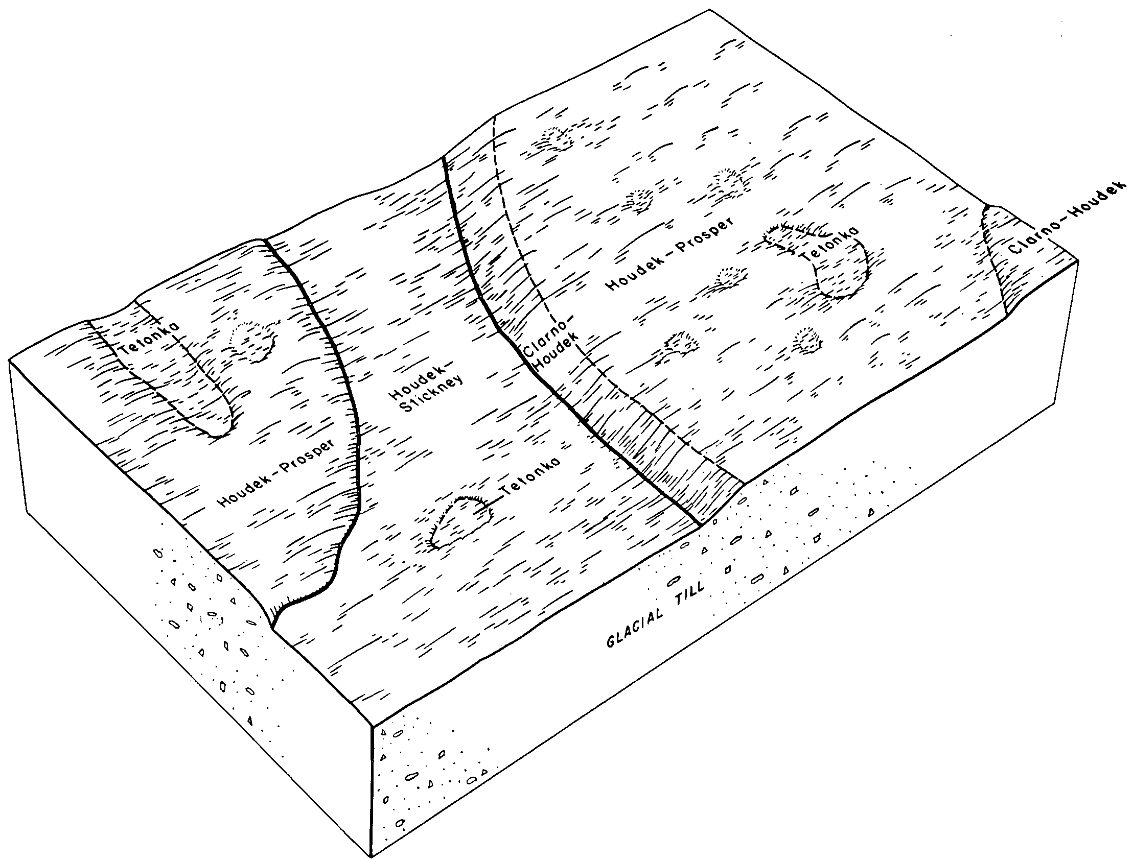
Houdek-Stickney-Tetonka complex, 0 to 2 percent slopes | Ht | 3347 | 417746 | 2wkpc | sd025 | 1992 | 1:20000 |
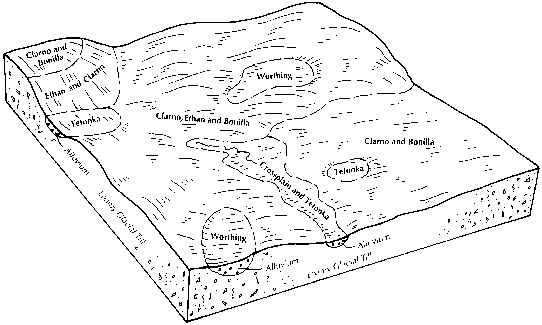
Crossplain-Tetonka complex | Ct | 500 | 417709 | g0nh | sd025 | 1992 | 1:20000 |
Tetonka silt loam, 0 to 1 percent slopes | Te | 321 | 417792 | 2tlcd | sd025 | 1992 | 1:20000 |
Davison-Tetonka-Egan complex, 0 to 3 percent slopes | DkA | 11448 | 445544 | gymd | sd027 | 1995 | 1:24000 |
Egan-Clarno-Tetonka complex, 0 to 2 percent slopes | EcA | 10056 | 445550 | gyml | sd027 | 1995 | 1:24000 |
Egan-Ethan-Tetonka complex, 0 to 6 percent slopes | EfB | 7382 | 445554 | gymq | sd027 | 1995 | 1:24000 |
Trent-Tetonka-Wakonda complex, 0 to 3 percent slopes | TtA | 4467 | 445617 | gypr | sd027 | 1995 | 1:24000 |
Wakonda-Tetonka silt loams, 0 to 2 percent slopes | Wa | 1469 | 445621 | gypw | sd027 | 1995 | 1:24000 |
Chancellor-Tetonka complex, 0 to 2 percent slopes | Ca | 1083 | 445536 | 2vwch | sd027 | 1995 | 1:24000 |
Ethan-Davison-Tetonka complex, 0 to 6 percent slopes | EuB | 1013 | 445569 | gyn6 | sd027 | 1995 | 1:24000 |
Enet-Storla-Tetonka complex, 0 to 6 percent slopes | EnB | 198 | 445560 | gymx | sd027 | 1995 | 1:24000 |
Tetonka silt loam, 0 to 2 percent slopes, frequently ponded | Te | 180 | 445612 | 2vwbq | sd027 | 1995 | 1:24000 |
Tetonka silt loam, 0 to 1 percent slopes | TeA | 15637 | 352938 | 2tlcd | sd035 | 1966 | 1:20000 |
Tetonka-Stickney complex, 0 to 3 percent slopes | TsA | 537 | 352939 | cv84 | sd035 | 1966 | 1:20000 |
Onita-Tetonka silt loams | On | 15367 | 354911 | cx9r | sd043 | 1979 | 1:20000 |
Tetonka silt loam, 0 to 1 percent slopes | Te | 13630 | 354915 | 2tlcd | sd043 | 1979 | 1:20000 |
Prosper-Tetonka complex | Pt | 9061 | 354913 | cx9t | sd043 | 1979 | 1:20000 |
Tetonka silt loam, 0 to 1 percent slopes | Tp | 38158 | 352683 | 2tlcd | sd059 | 1959 | 1:20000 |
Tetonka silt loam, 0 to 1 percent slopes | Te | 1766 | 353854 | 2tlcd | sd069 | 1992 | 1:20000 |
Tetonka silt loam, 0 to 1 percent slopes | Te | 4957 | 356461 | 2tlcd | sd073 | 1987 | 1:20000 |
Houdek-Stickney-Tetonka complex, 0 to 2 percent slopes | Ht | 20434 | 417491 | 2wkpc | sd077 | 1992 | 1:20000 |
Crossplain-Tetonka complex | Ct | 9729 | 417467 | g0dp | sd077 | 1992 | 1:20000 |
Tetonka silt loam, 0 to 1 percent slopes | Te | 2872 | 417518 | 2tlcd | sd077 | 1992 | 1:20000 |
Stickney-Tetonka complex, 0 to 2 percent slopes | StA | 2515 | 416515 | fzdz | sd079 | 1967 | 1:20000 |
Tetonka silt loam, 0 to 2 percent slopes, frequently ponded | Te | 2437 | 416517 | 2vwbq | sd079 | 1967 | 1:20000 |
Chancellor-Tetonka complex, 0 to 2 percent slopes | Ca | 28560 | 416626 | 2vwch | sd083 | 1971 | 1:20000 |
Chancellor-Wakonda-Tetonka complex | Ch | 17587 | 416628 | fzjm | sd083 | 1971 | 1:20000 |
Tetonka silt loam, 0 to 2 percent slopes, frequently ponded | Te | 4468 | 416660 | 2vwbq | sd083 | 1971 | 1:20000 |
Tetonka silt loam, 0 to 1 percent slopes | Tb | 9139 | 418035 | 2tlcd | sd087 | 1976 | 1:20000 |
Tetonka-Canisteo complex | Tc | 1946 | 418036 | g101 | sd087 | 1976 | 1:20000 |
Wentworth-Trent-Tetonka complex, 0 to 3 percent slopes | WdA | 1423 | 418042 | g107 | sd087 | 1976 | 1:20000 |
Houdek-Stickney-Tetonka complex, 0 to 2 percent slopes | CnA | 42563 | 355390 | 2wkpc | sd097 | 1983 | 1:20000 |
Houdek-Dudley-Tetonka complex, 0 to 6 percent slopes | HgB | 31292 | 355404 | 2yyhg | sd097 | 1983 | 1:20000 |
Clarno-Stickney-Tetonka complex, 0 to 6 percent slopes | CnB | 30316 | 355391 | cxt7 | sd097 | 1983 | 1:20000 |
Crossplain-Tetonka complex | Ct | 22063 | 355392 | cxt8 | sd097 | 1983 | 1:20000 |
Tetonka silt loam, 0 to 1 percent slopes | Te | 3411 | 355410 | 2tlcd | sd097 | 1983 | 1:20000 |
Chancellor-Tetonka complex, 0 to 2 percent slopes | Ca | 746 | 355384 | 2vwch | sd097 | 1983 | 1:20000 |
Chancellor-Tetonka complex, 0 to 2 percent slopes | Cc | 7313 | 446007 | 2vwch | sd099 | 1995 | 1:24000 |
Tetonka silt loam, 0 to 2 percent slopes, frequently ponded | Te | 420 | 446080 | 2vwbq | sd099 | 1995 | 1:24000 |
Agar-Mobridge-Tetonka silt loams, 0 to 3 percent slopes | AoA | 3265 | 355312 | cxqp | sd107 | 1983 | 1:20000 |
Tetonka silt loam, 0 to 1 percent slopes | Te | 2927 | 355374 | 2tlcd | sd107 | 1983 | 1:20000 |
Tetonka silt loam, 0 to 1 percent slopes | Tb | 21524 | 354811 | 2tlcd | sd111 | 1978 | 1:20000 |
Tetonka-Davison-Clarno complex, 0 to 2 percent slopes | TcA | 15788 | 354812 | cx6k | sd111 | 1978 | 1:20000 |
Tetonka loamy fine sand, overblown | Ta | 1653 | 354810 | cx6h | sd111 | 1978 | 1:20000 |
Tetonka variant fine sandy loam | Td | 1179 | 354813 | cx6l | sd111 | 1978 | 1:20000 |
Houdek-Stickney-Tetonka complex, 0 to 2 percent slopes | HxA | 8872 | 356660 | 2wkpc | sd115 | 1997 | 1:24000 |
Crossplain-Tetonka complex, 0 to 1 percent slopes | Ct | 3218 | 356582 | cz1n | sd115 | 1997 | 1:24000 |
Tetonka silt loam, 0 to 1 percent slopes | Te | 2663 | 356712 | 2tlcd | sd115 | 1997 | 1:24000 |
Davison-Tetonka complex, 0 to 2 percent slopes | Dd | 1008 | 356585 | cz1r | sd115 | 1997 | 1:24000 |
Tetonka silt loam, 0 to 1 percent slopes | Te | 8080 | 418241 | 2tlcd | sd125 | 1980 | 1:20000 |
Tetonka silt loam, 0 to 1 percent slopes | Te | 828 | 354533 | 2tlcd | sd129 | 1975 | 1:20000 |
Tetonka silt loam, 0 to 1 percent slopes | Tb | 4013 | 418107 | 2tlcd | sd135 | 1977 | 1:20000 |
Tetonka silt loam, 0 to 1 percent slopes | Te | 50446 | 417997 | 2tlcd | sd602 | 1975 | 1:20000 |
Tetonka and Whitewood silty clay loams | Tw | 20334 | 417999 | g0yv | sd602 | 1975 | 1:20000 |
Tetonka-Harps complex | Tt | 9483 | 417998 | g0yt | sd602 | 1975 | 1:20000 |