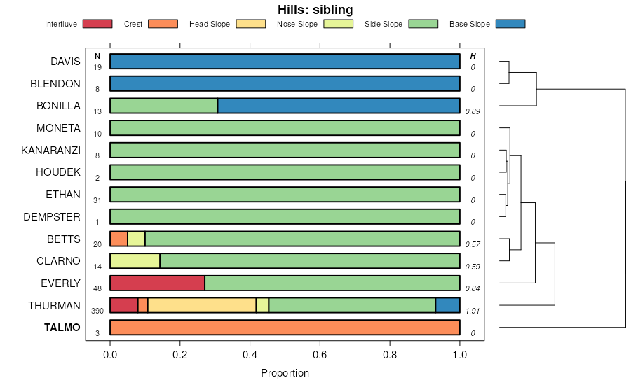
| Talmo gravelly sandy loam, 6 to 35 percent slopes | P37D | 82 | 725690 | sc4c | mn101 | 2008 | 1:12000 |
Moneta-Everly-Talmo complex, 12 to 18 percent slopes, moderately eroded | P52D2 | 63 | 725684 | sc45 | mn101 | 2008 | 1:12000 |
Everly-Moneta-Talmo complex, 6 to 12 percent slopes, moderately eroded | P51C2 | 1 | 1946880 | 23bwl | mn101 | 2008 | 1:12000 |
Everly-Moneta-Talmo complex, 6 to 12 percent slopes, moderately eroded | P51C2 | 630 | 630069 | p4mt | mn105 | 2004 | 1:12000 |
Moneta-Everly-Talmo complex, 12 to 18 percent slopes, moderately eroded | P52D2 | 144 | 630061 | p4mk | mn105 | 2004 | 1:12000 |
Talmo gravelly sandy loam, 6 to 35 percent slopes | P37D | 86 | 630053 | p4m9 | mn105 | 2004 | 1:12000 |
Talmo gravelly sandy loam, 6 to 35 percent slopes | P37D | 461 | 1674446 | 1t6dd | mn117 | 2005 | 1:12000 |
Talmo gravelly sandy loam, 2 to 6 percent slopes | P37B | 291 | 725511 | sbyl | mn117 | 2005 | 1:12000 |
Talmo gravelly sandy loam, 6 to 35 percent slopes | P37D | 1075 | 432675 | gj78 | mn133 | 2002 | 1:12000 |
Talmo gravelly sandy loam, 2 to 6 percent slopes | P37B | 551 | 432674 | gj77 | mn133 | 2002 | 1:12000 |
Simeon-Talmo-Ortello complex, 11 to 30 percent slopes | 8937 | 6069 | 427134 | gbgj | ne027 | 1982 | 1:20000 |
Talmo-Loretto complex, 3 to 11 percent slopes | 6830 | 3215 | 427135 | gbgk | ne027 | 1982 | 1:20000 |
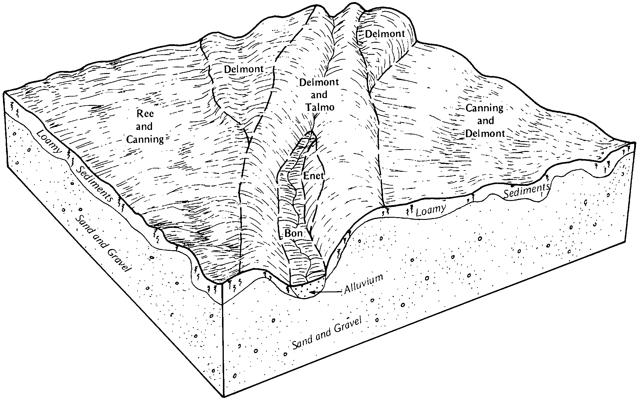
Delmont-Talmo complex, 6 to 15 percent slopes | DnC | 2562 | 354842 | cx7j | sd003 | 1979 | 1:20000 |
Talmo-Delmont complex, 15 to 40 percent slopes | TdE | 399 | 354868 | cx8c | sd003 | 1979 | 1:20000 |
Talmo gravelly loam, 2 to 15 percent slopes | TaC | 327 | 354867 | cx8b | sd003 | 1979 | 1:20000 |
Delmont-Talmo complex, 2 to 6 percent slopes | DfB | 3639 | 354562 | cwyh | sd005 | 1976 | 1:20000 |
Talmo-Ethan very stony complex, 6 to 40 percent slopes | TbE | 1334 | 418288 | g185 | sd009 | 1981 | 1:20000 |
Talmo-Delmont loams, 15 to 40 percent slopes | TaE | 589 | 418287 | g184 | sd009 | 1981 | 1:20000 |
Delmont-Talmo loams, 6 to 9 percent slopes | DlC | 273 | 418258 | g176 | sd009 | 1981 | 1:20000 |
Delmont-Talmo complex, 2 to 9 percent slopes | DmC | 1063 | 355014 | cxf2 | sd023 | 1980 | 1:20000 |
Talmo-Betts complex, 9 to 25 percent slopes | TbE | 333 | 355073 | cxgz | sd023 | 1980 | 1:20000 |
Talmo gravelly sandy loam, 2 to 9 percent slopes | TaC | 188 | 355072 | cxgy | sd023 | 1980 | 1:20000 |
Ethan-Talmo complex, 15 to 40 percent slopes | EzE | 89 | 445571 | gyn8 | sd027 | 1995 | 1:24000 |
Delmont-Talmo complex, 6 to 15 percent slopes | DnD | 54 | 445546 | gymg | sd027 | 1995 | 1:24000 |
Talmo-Thurman complex, 15 to 40 percent slopes | TaE | 25 | 445611 | gypk | sd027 | 1995 | 1:24000 |
Delmont-Talmo loams, 2 to 9 percent slopes | DmC | 1648 | 354890 | cx92 | sd043 | 1979 | 1:20000 |
Talmo gravelly sandy loam, 2 to 9 percent slopes | TaC | 366 | 354914 | cx9v | sd043 | 1979 | 1:20000 |
Delmont-Talmo loams, 6 to 9 percent slopes | DtC | 53 | 3466277 | 30t3v | sd049 | 1981 | 1:20000 |
Betts-Talmo loams, hilly | ZsD | 2097 | 352710 | cv0r | sd059 | 1959 | 1:20000 |
Talmo gravelly sandy loam | Rs | 812 | 352675 | ctzm | sd059 | 1959 | 1:20000 |
Houdek-Talmo complex, hilly | HsD | 750 | 352625 | 2yyhc | sd059 | 1959 | 1:20000 |
Talmo gravelly loam | Hg | 646 | 352613 | ctxm | sd059 | 1959 | 1:20000 |
Glenham-Talmo loams, hilly | WuD | 433 | 352700 | cv0f | sd059 | 1959 | 1:20000 |
Betts-talmo loams, steep | ZsE | 400 | 352711 | cv0s | sd059 | 1959 | 1:20000 |
Talmo-Delmont loams, 3 to 15 percent slopes | TdD | 4236 | 353853 | cw6m | sd069 | 1992 | 1:20000 |
Talmo loam, 9 to 25 percent slopes | TaE | 965 | 353850 | cw6j | sd069 | 1992 | 1:20000 |
Orton-Talmo loams, 9 to 25 percent slopes | OxD | 821 | 353833 | cw5z | sd069 | 1992 | 1:20000 |
Talmo, stony-Java loams, 9 to 40 percent slopes | TcF | 427 | 353852 | cw6l | sd069 | 1992 | 1:20000 |
Talmo sandy loam, 0 to 3 percent slopes | TbA | 111 | 353851 | cw6k | sd069 | 1992 | 1:20000 |
Delmont-Talmo loams, 9 to 20 percent slopes | DmD | 2739 | 356422 | cywh | sd073 | 1987 | 1:20000 |
Delmont-Talmo loams, 2 to 6 percent slopes | DtB | 1428 | 417473 | g0dw | sd077 | 1992 | 1:20000 |
Talmo-Delmont loams, 6 to 15 percent slopes | TdD | 163 | 417517 | g0g9 | sd077 | 1992 | 1:20000 |
Delmont-Talmo loams, 2 to 6 percent slopes | DeB | 1138 | 416481 | fzcw | sd079 | 1967 | 1:20000 |
Talmo-Delmont loams, 6 to 21 percent slopes | TdE | 1041 | 416516 | fzf0 | sd079 | 1967 | 1:20000 |
Delmont-Talmo loams, 6 to 9 percent slopes | DeC | 451 | 416482 | fzcx | sd079 | 1967 | 1:20000 |
Delmont and Talmo soils, 2 to 9 percent slopes | DkB | 1291 | 416635 | fzjv | sd083 | 1971 | 1:20000 |
Shindler and Talmo soils, 6 to 30 percent slopes | StD | 574 | 416658 | fzkl | sd083 | 1971 | 1:20000 |
Talmo-Betts loams, 6 to 15 percent slopes | TaD | 1181 | 418034 | g0zz | sd087 | 1976 | 1:20000 |
Talmo soils, 6 to 15 percent slopes | TeD | 793 | 418038 | g103 | sd087 | 1976 | 1:20000 |
Shindler-Talmo complex, 15 to 40 percent slopes | SnE | 1256 | 446075 | gz5j | sd099 | 1995 | 1:24000 |
Delmont-Talmo complex, 6 to 9 percent slopes | DgC | 1098 | 446023 | gz3v | sd099 | 1995 | 1:24000 |
Houdek-Talmo complex, 9 to 15 percent slopes | HtD | 947 | 446052 | gz4s | sd099 | 1995 | 1:24000 |
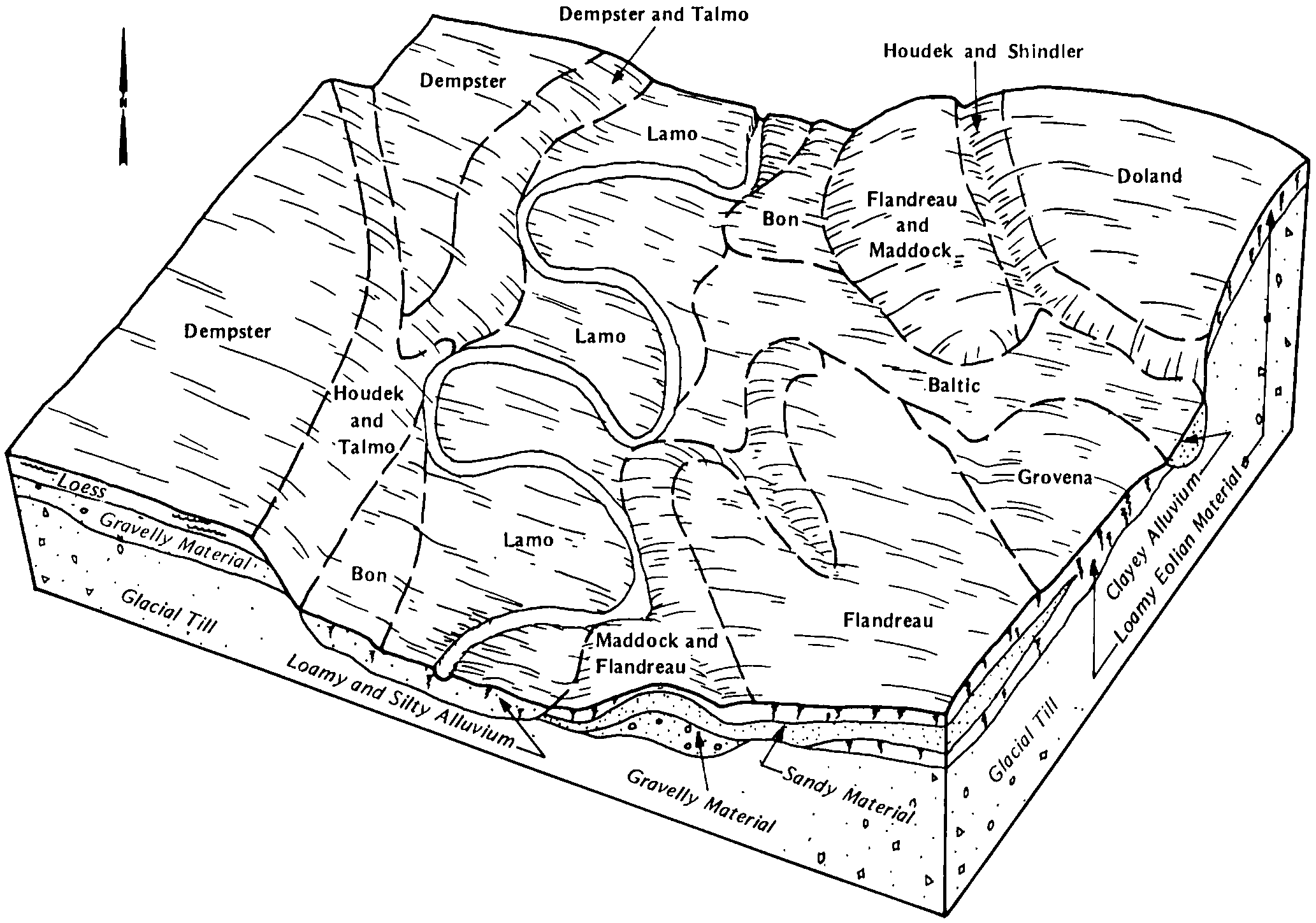
Dempster-Talmo complex, 2 to 6 percent slopes | DtB | 735 | 446027 | gz3z | sd099 | 1995 | 1:24000 |
Delmont-Talmo complex, 9 to 15 percent slopes | DgD | 725 | 446024 | gz3w | sd099 | 1995 | 1:24000 |
Talmo-Delmont complex, 15 to 40 percent slopes | TdE | 150 | 446079 | gz5n | sd099 | 1995 | 1:24000 |
Dempster-Talmo complex, 2 to 9 percent slopes | DnB | 1806 | 418317 | g193 | sd101 | 1985 | 1:20000 |
Houdek-Talmo complex, 6 to 40 percent slopes | HtD | 1286 | 418338 | g19s | sd101 | 1985 | 1:20000 |
Delmont-Talmo complex, 6 to 40 percent slopes | DgD | 168 | 418314 | g190 | sd101 | 1985 | 1:20000 |
Hand-Talmo complex, 2 to 6 percent slopes | HjB | 2650 | 356645 | 2yygq | sd115 | 1997 | 1:24000 |
Hand-Talmo complex, 6 to 9 percent slopes | HjC | 721 | 356646 | 2yygr | sd115 | 1997 | 1:24000 |
Talmo-Ethan complex, 9 to 40 percent slopes, very stony | TbE | 448 | 356711 | cz5t | sd115 | 1997 | 1:24000 |
Talmo gravelly loam, 9 to 25 percent slopes | TaE | 5091 | 353132 | cvgc | sd119 | 1967 | 1:20000 |
Oahe-Talmo loams, 0 to 2 percent slopes | OhA | 3090 | 353099 | cvf9 | sd119 | 1967 | 1:20000 |
Oahe-Talmo loams, 2 to 6 percent slopes | OhB | 2570 | 353100 | cvfb | sd119 | 1967 | 1:20000 |
Betts-Talmo complex, 12 to 40 percent slopes | BhE | 1708 | 418206 | g15j | sd125 | 1980 | 1:20000 |
Talmo-Thurman complex, 15 to 40 percent slopes | TaE | 1544 | 418106 | g129 | sd135 | 1977 | 1:20000 |
Ethan-Talmo loams, 6 to 15 percent slopes | EpD | 748 | 418084 | g11l | sd135 | 1977 | 1:20000 |
Delmont-Talmo complex, 6 to 12 percent slopes | DnD | 1509 | 417957 | g0xh | sd602 | 1975 | 1:20000 |

