| Sylvan silty clay loam, 10 to 18 percent slopes, severely eroded | 19D3 | 2309 | 172949 | 5sz0 | il009 | 1984 | 1:12000 |
Sylvan silty clay loam, 5 to 10 percent slopes, severely eroded | 19C3 | 946 | 172948 | 5syz | il009 | 1984 | 1:12000 |
Sylvan silt loam, 18 to 35 percent slopes, severely eroded | 19F3 | 660 | 172950 | 5sz1 | il009 | 1984 | 1:12000 |
Sylvan silt loam, 35 to 60 percent slopes | 19G | 2196 | 1862656 | 20j7p | il011 | 2007 | 1:12000 |
Sylvan silt loam, 10 to 18 percent slopes | 19D | 741 | 1862654 | 20j7m | il011 | 2007 | 1:12000 |
Sylvan silty clay loam, 10 to 18 percent slopes, severely eroded | 19D3 | 635 | 1862655 | 20j7n | il011 | 2007 | 1:12000 |
Sylvan silty clay loam, 18 to 35 percent slopes, severely eroded | 19F3 | 1750 | 175502 | 5wmc | il013 | 1986 | 1:15840 |
Sylvan silty clay loam, 10 to 18 percent slopes, severely eroded | 19D3 | 1631 | 175501 | 5wmb | il013 | 1986 | 1:15840 |
Sylvan silt loam, 10 to 18 percent slopes, eroded | 19D2 | 1208 | 175500 | 5wm9 | il013 | 1986 | 1:15840 |
Sylvan silty clay loam, terrace, 10 to 18 percent slopes, severely eroded | 9019D3 | 103 | 2542375 | 2qzks | il013 | 1986 | 1:15840 |
Sylvan-Bold complex, 10 to 18 percent slopes, severely eroded | 962D3 | 8540 | 262827 | 8th9 | il017 | 2003 | 1:12000 |
Sylvan-Bold silt loams, 18 to 25 percent slopes, eroded | 962E2 | 6839 | 262828 | 8thb | il017 | 2003 | 1:12000 |
Sylvan-Bold Complex, 5 to 10 percent slopes, severely eroded | 962C3 | 4006 | 262826 | 8th8 | il017 | 2003 | 1:12000 |
Sylvan-Bold silt loams, 10 to 18 percent slopes, eroded | 962D2 | 2546 | 780783 | v6gk | il017 | 2003 | 1:12000 |
Sylvan-Bold silt loams, 18 to 35 percent slopes | 962F | 577 | 758469 | tg7r | il017 | 2003 | 1:12000 |
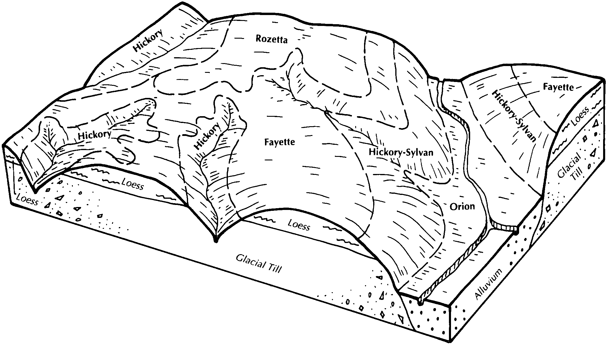
Sylvan silty clay loam, 10 to 18 percent slopes, severely eroded | 19D3 | 6331 | 615624 | nnlv | il057 | 1997 | 1:12000 |
Sylvan-Bold silt loams, 35 to 60 percent slopes | 962G | 4669 | 211793 | 73d1 | il061 | 1968 | 1:15840 |
Sylvan-Bold silt loams, 18 to 25 percent slopes, eroded | 962E2 | 1495 | 211792 | 73d0 | il061 | 1968 | 1:15840 |
Sylvan-Bold silt loams, 18 to 35 percent slopes | 962F | 1171 | 211791 | 73cz | il061 | 1968 | 1:15840 |
Sylvan-Bold silt loams, 10 to 18 percent slopes, eroded | 962D2 | 1051 | 211790 | 73cy | il061 | 1968 | 1:15840 |
Sylvan silty clay loam, 10 to 18 percent slopes, severely eroded | 19D3 | 16893 | 244624 | 86k3 | il073 | 2001 | 1:12000 |
Sylvan silt loam, 10 to 18 percent slopes, eroded | 19D2 | 6507 | 244623 | 86k2 | il073 | 2001 | 1:12000 |
Sylvan silt loam, 18 to 35 percent slopes | 19F | 3377 | 244625 | 86k4 | il073 | 2001 | 1:12000 |
Sylvan-Bold complex, 10 to 18 percent slopes, severely eroded | 962D3 | 3084 | 244783 | 86q7 | il073 | 2001 | 1:12000 |
Sylvan-Bold silt loams, 35 to 60 percent slopes | 962G | 3651 | 728443 | sg05 | il083 | 2002 | 1:12000 |
Sylvan-Bold silt loams, 18 to 35 percent slopes | 962F | 1916 | 728442 | sg04 | il083 | 2002 | 1:12000 |
Sylvan-Bold silt loams, 18 to 25 percent slopes, eroded | 962E2 | 1605 | 728445 | sg07 | il083 | 2002 | 1:12000 |
Sylvan-Bold silt loams, 10 to 18 percent slopes, eroded | 962D2 | 914 | 728439 | sg01 | il083 | 2002 | 1:12000 |
Sylvan-Bold complex, 10 to 18 percent slopes, severely eroded | 962D3 | 217 | 728441 | sg03 | il083 | 2002 | 1:12000 |
Sylvan-Bold complex, terrace, 10 to 18 percent slopes, severely eroded | 9962D3 | 147 | 728475 | sg16 | il083 | 2002 | 1:12000 |
Sylvan silty clay loam, 5 to 10 percent slopes, severely eroded | 19C3 | 2196 | 680859 | qvh6 | il095 | 2002 | 1:12000 |
Sylvan silty clay loam, 10 to 18 percent slopes, severely eroded | 19D3 | 688 | 680860 | qvh7 | il095 | 2002 | 1:12000 |
Hickory-Sylvan complex, 18 to 35 percent slopes, eroded | 898F2 | 903 | 1596069 | 1qkv3 | il107 | 2006 | 1:12000 |
Sylvan-Bold silt loams, 18 to 35 percent slopes, eroded | 962F2 | 4130 | 198923 | 6nzw | il119 | 2001 | 1:12000 |
Sylvan-Bold silt loams, 10 to 18 percent slopes, eroded | 962D2 | 1955 | 198922 | 6nzv | il119 | 2001 | 1:12000 |
Sylvan silty clay loam, 5 to 10 percent slopes, severely eroded | 19C3 | 179 | 182107 | 63hf | il123 | 1997 | 1:15840 |
Sylvan silty clay loam, 10 to 18 percent slopes, severely eroded | 19D3 | 23 | 182108 | 63hg | il123 | 1997 | 1:15840 |
Sylvan-Bold silt loams, 10 to 18 percent slopes, eroded | 962D2 | 3928 | 1406116 | 1j65l | il129 | 2005 | 1:12000 |
Hickory-Sylvan complex, 18 to 35 percent slopes, eroded | 898F2 | 3548 | 1486734 | 1lx25 | il129 | 2005 | 1:12000 |
Sylvan-Bold silt loams, 5 to 10 percent slopes, eroded | 962C2 | 3071 | 1486967 | 1lx9p | il129 | 2005 | 1:12000 |
Sylvan-Bold silt loams, 18 to 35 percent slopes, eroded | 962F2 | 2859 | 1486744 | 1lx2h | il129 | 2005 | 1:12000 |
Sylvan-Bold complex, 5 to 10 percent slopes, severely eroded | 962C3 | 2771 | 1406054 | 1j63l | il129 | 2005 | 1:12000 |
Sylvan-Bold complex, 10 to 18 percent slopes, severely eroded | 962D3 | 1610 | 1406123 | 1j65t | il129 | 2005 | 1:12000 |
Hickory-Sylvan complex, 10 to 18 percent slopes, eroded | 898D2 | 1192 | 1406632 | 1j6q7 | il129 | 2005 | 1:12000 |
Hickory-Sylvan complex, 18 to 35 percent slopes, severely eroded | 898F3 | 719 | 1486738 | 1lx29 | il129 | 2005 | 1:12000 |
Hickory-Sylvan silt loams, 35 to 60 percent slopes | 898G | 682 | 1407034 | 1j746 | il129 | 2005 | 1:12000 |
Hickory-Sylvan complex, 10 to 18 percent slopes, severely eroded | 898D3 | 648 | 1406633 | 1j6q8 | il129 | 2005 | 1:12000 |
Sylvan-Bold silt loams, 35 to 60 percent slopes | 962G | 395 | 1406044 | 1j638 | il129 | 2005 | 1:12000 |
Sylvan-Bold silt loams, 18 to 25 percent slopes, eroded | 962E2 | 296 | 1488479 | 1lywg | il129 | 2005 | 1:12000 |
Hickory-Sylvan silt loams, 35 to 60 percent slopes | 898G | 10440 | 245011 | 86yl | il131 | 2000 | 1:12000 |
Sylvan silty clay loam, 10 to 18 percent slopes, severely eroded | 19D3 | 9763 | 244944 | 86wf | il131 | 2000 | 1:12000 |
Sylvan-Bold complex, 10 to 18 percent slopes, severely eroded | 962D3 | 3350 | 245019 | 86yv | il131 | 2000 | 1:12000 |
Sylvan silt loam, 10 to 18 percent slopes, eroded | 19D2 | 1405 | 244943 | 86wd | il131 | 2000 | 1:12000 |
Hickory-Sylvan-Fayette silt loams, 18 to 35 percent slopes | 960F | 40 | 245018 | 86yt | il131 | 2000 | 1:12000 |
Hickory-Sylvan complex, 18 to 35 percent slopes, severely eroded | 898F3 | 16 | 245010 | 86yk | il131 | 2000 | 1:12000 |
Sylvan silty clay loam, 5 to 10 percent slopes, severely eroded | 19C3 | 5771 | 1672120 | 1t3zc | il137 | 1984 | 1:15840 |
Sylvan-Bold complex, 18 to 25 percent slopes, severely eroded | 962E3 | 3012 | 1672188 | 1t41k | il137 | 1984 | 1:15840 |
Sylvan silty clay loam, 10 to 18 percent slopes, severely eroded | 19D3 | 2260 | 1672122 | 1t3zf | il137 | 1984 | 1:15840 |
Sylvan-Bold silt loams, 18 to 25 percent slopes, eroded | 962E2 | 2014 | 1672187 | 1t41j | il137 | 1984 | 1:15840 |
Sylvan silt loam, 10 to 18 percent slopes, eroded | 19D2 | 2010 | 1672121 | 1t3zd | il137 | 1984 | 1:15840 |
Sylvan silt loam, 18 to 25 percent slopes, eroded | 19E2 | 1265 | 1672123 | 1t3zg | il137 | 1984 | 1:15840 |
Sylvan-Bold complex, 10 to 18 percent slopes, severely eroded | 962D3 | 1062 | 1672186 | 1t41h | il137 | 1984 | 1:15840 |
Sylvan silty clay loam, 18 to 25 percent slopes, severely eroded | 19E3 | 997 | 1672124 | 1t3zh | il137 | 1984 | 1:15840 |
Sylvan-Bold silt loams, 10 to 18 percent slopes, eroded | 962D2 | 73 | 2542163 | 2qvjq | il137 | 1984 | 1:15840 |
Sylvan-Bold complex, 5 to 10 percent slopes, severely eroded | 962C3 | 51 | 2542162 | 2qvjp | il137 | 1984 | 1:15840 |
Sylvan silty clay loam, 5 to 10 percent slopes, severely eroded | 19C3 | 16606 | 209026 | 70hs | il143 | 1986 | 1:15840 |
Sylvan silty clay loam, 10 to 18 percent slopes, severely eroded | 19D3 | 3163 | 209027 | 70ht | il143 | 1986 | 1:15840 |
Sylvan silty clay loam, 18 to 25 percent slopes, severely eroded | 19E3 | 1268 | 209028 | 70hv | il143 | 1986 | 1:15840 |
Sylvan silty clay loam, 10 to 18 percent slopes, severely eroded | 19D3 | 1424 | 201094 | 6r7x | il149 | 2001 | 1:12000 |
Hickory-Sylvan-Fayette silt loams, 18 to 30 percent slopes | 960F | 11681 | 198769 | 6ntx | il161 | 2002 | 1:12000 |
Sylvan silty clay loam, 10 to 18 percent slopes, severely eroded | 19D3 | 8617 | 198675 | 6nqw | il161 | 2002 | 1:12000 |
Hickory-Sylvan silt loams, 35 to 60 percent slopes | 898G | 8132 | 198758 | 6ntk | il161 | 2002 | 1:12000 |
Hickory-Sylvan-Fayette silt loams, 10 to 18 percent slopes, eroded | 960D2 | 5102 | 198767 | 6ntv | il161 | 2002 | 1:12000 |
Sylvan silt loam, 18 to 35 percent slopes | 19F | 4552 | 198676 | 6nqx | il161 | 2002 | 1:12000 |
Sylvan silty clay loam, 5 to 10 percent slopes, severely eroded | 19C3 | 2453 | 271430 | 93ft | il161 | 2002 | 1:12000 |
Sylvan silty clay loam, 18 to 35 percent slopes, severely eroded | 19F3 | 1705 | 198677 | 6nqy | il161 | 2002 | 1:12000 |
Hickory-Sylvan-Fayette complex, 10 to 18 percent slopes, severely eroded | 960D3 | 1575 | 198768 | 6ntw | il161 | 2002 | 1:12000 |
Sylvan silt loam, 10 to 18 percent slopes | 19D | 1461 | 198674 | 6nqv | il161 | 2002 | 1:12000 |
Hickory-Sylvan complex, 18 to 35 percent slopes, severely eroded | 898F3 | 1318 | 198757 | 6ntj | il161 | 2002 | 1:12000 |
Sylvan-Bold silt loams, 18 to 35 percent slopes | 962F | 1312 | 198764 | 6ntr | il161 | 2002 | 1:12000 |
Sylvan-Bold silt loams, 18 to 35 percent slopes, eroded | 962F2 | 4825 | 183198 | 64mm | il163 | 1997 | 1:12000 |
Sylvan-Bold silt loams, 35 to 60 percent slopes | 962G | 1941 | 183200 | 64mp | il163 | 1997 | 1:12000 |
Sylvan silty clay loam, 10 to 18 percent slopes, severely eroded | 19D3 | 1275 | 202176 | 6sct | il169 | 2000 | 1:12000 |
Sylvan-Bold silt loams, 18 to 25 percent slopes, eroded | 962E2 | 3395 | 2542083 | 2qrcm | il171 | 1984 | 1:12000 |
Sylvan silty clay loam, 5 to 10 percent slopes, severely eroded | 19C3 | 2212 | 1605813 | 1qwzf | il171 | 1984 | 1:12000 |
Sylvan silty clay loam, 10 to 18 percent slopes, severely eroded | 19D3 | 1906 | 2542048 | 2qrb8 | il171 | 1984 | 1:12000 |
Sylvan-Bold complex, 18 to 25 percent slopes, severely eroded | 962E3 | 1243 | 2542084 | 2qrcn | il171 | 1984 | 1:12000 |
Sylvan silty clay loam, 18 to 25 percent slopes, severely eroded | 19E3 | 816 | 2542051 | 2qrbc | il171 | 1984 | 1:12000 |
Sylvan-Bold complex, 10 to 18 percent slopes, severely eroded | 962D3 | 800 | 2542082 | 2qrcl | il171 | 1984 | 1:12000 |
Sylvan silt loam, 10 to 18 percent slopes, eroded | 19D2 | 598 | 2542049 | 2qrb9 | il171 | 1984 | 1:12000 |
Sylvan silt loam, 18 to 25 percent slopes, eroded | 19E2 | 522 | 2542050 | 2qrbb | il171 | 1984 | 1:12000 |
Sylvan-Bold silt loams, 10 to 18 percent slopes, eroded | 962D2 | 9 | 2542081 | 2qrck | il171 | 1984 | 1:12000 |
Sylvan silty clay loam, 10 to 18 percent slopes, severely eroded | 19D3 | 2464 | 179073 | 60bk | il175 | 1992 | 1:15840 |
Sylvan silty clay loam, 5 to 10 percent slopes, severely eroded | 19C3 | 1112 | 179072 | 60bj | il175 | 1992 | 1:15840 |
Sylvan silt loam, 18 to 35 percent slopes | 19F | 813 | 179074 | 60bl | il175 | 1992 | 1:15840 |
Sylvan silt loam, 10 to 18 percent slopes, eroded | 19D2 | 1630 | 179368 | 60n2 | il179 | 1991 | 1:15840 |
Sylvan silt loam, 5 to 10 percent slopes, eroded | 19C2 | 525 | 179367 | 60n1 | il179 | 1991 | 1:15840 |
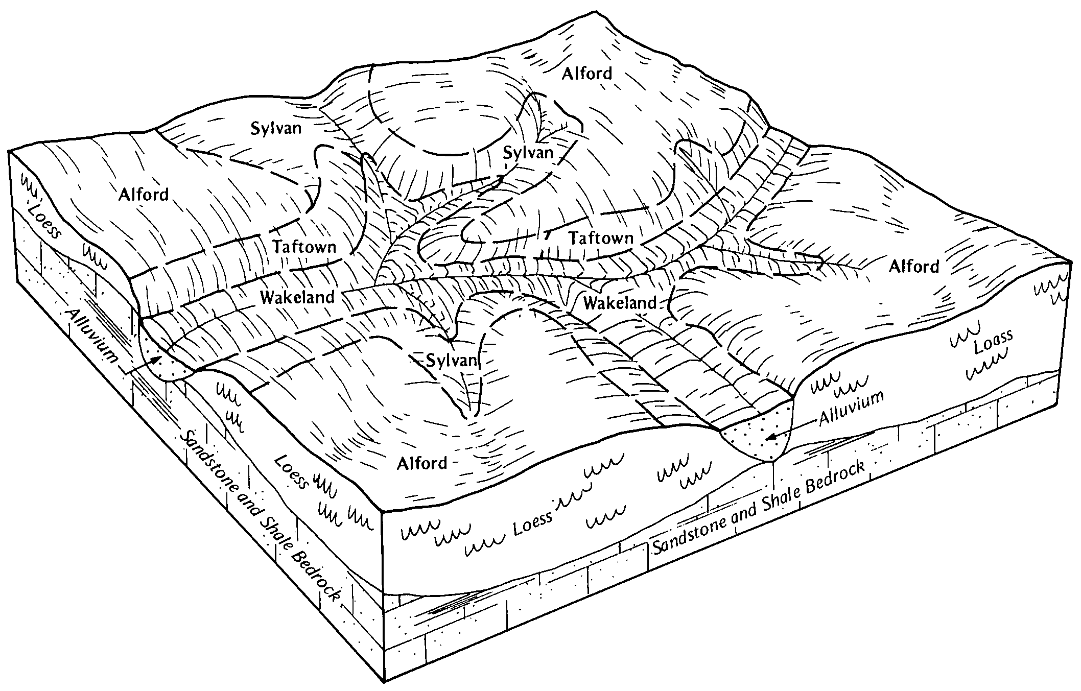
Sylvan-Hickory silt loams, 35 to 70 percent slopes | 898G | 1996 | 1543929 | 1ntl5 | il193 | 2006 | 1:12000 |
Sylvan silt loam, 18 to 35 percent slopes | 19F | 695 | 1543863 | 1ntj1 | il193 | 2006 | 1:12000 |
Sylvan silt loam, 6 to 12 percent slopes, severely eroded | SyC3 | 3833 | 160161 | 5cnh | in051 | 1986 | 1:15840 |
Sylvan silt loam, 18 to 50 percent slopes | SyF | 3424 | 160163 | 5cnk | in051 | 1986 | 1:15840 |
Sylvan silt loam, 2 to 6 percent slopes, eroded | SyB2 | 1848 | 160160 | 5cng | in051 | 1986 | 1:15840 |
Udorthents-Sylvan complex, 12 to 18 percent slopes, severely eroded | UmD3 | 1192 | 160167 | 5cnp | in051 | 1986 | 1:15840 |
Sylvan silt loam, 12 to 18 percent slopes | SyD | 321 | 160162 | 5cnj | in051 | 1986 | 1:15840 |
Sylvan silt loam, 2 to 6 percent slopes, eroded | SyB2 | 19110 | 164505 | 5j5m | in083 | 1979 | 1:15840 |
Sylvan silt loam, 25 to 40 percent slopes | SyF | 3710 | 164508 | 5j5q | in083 | 1979 | 1:15840 |
Sylvan silt loam, 6 to 12 percent slopes, severely eroded | SyC3 | 3004 | 164506 | 5j5n | in083 | 1979 | 1:15840 |
Sylvan silt loam, 12 to 18 percent slopes, severely eroded | SyD3 | 1438 | 164507 | 5j5p | in083 | 1979 | 1:15840 |
Sylvan silt loam, 2 to 6 percent slopes, eroded | SyB2 | 1072 | 161939 | 5fhv | in125 | 1983 | 1:15840 |
Sylvan silt loam, 6 to 12 percent slopes, severely eroded | SyC3 | 620 | 161940 | 5fhw | in125 | 1983 | 1:15840 |
Sylvan silt loam, 25 to 50 percent slopes | SyF | 204 | 161941 | 5fhx | in125 | 1983 | 1:15840 |
Sylvan silt loam, 6 to 12 percent slopes, severely eroded | SyC3 | 6944 | 159916 | 5cdl | in129 | 1978 | 1:15840 |
Sylvan silt loam, 18 to 40 percent slopes | SyF | 5500 | 159918 | 5cdn | in129 | 1978 | 1:15840 |
Sylvan silt loam, 12 to 18 percent slopes, severely eroded | SyD3 | 4432 | 159917 | 5cdm | in129 | 1978 | 1:15840 |
Sylvan silt loam, 2 to 6 percent slopes, severely eroded | SyB3 | 397 | 159915 | 5cdk | in129 | 1978 | 1:15840 |