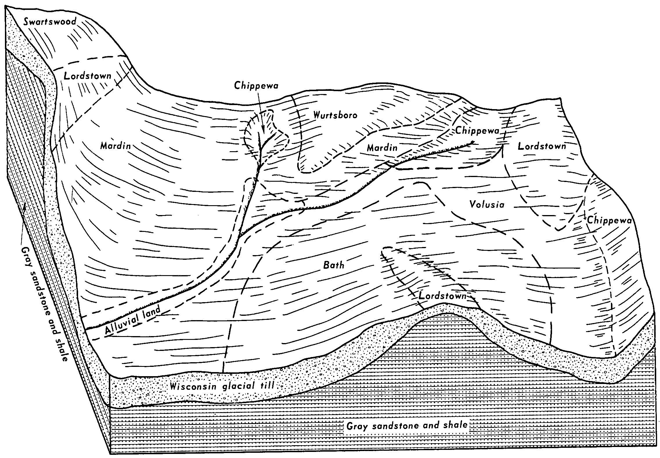
| Swartswood-Rock outcrop complex, 3 to 15 percent slopes | SwhC | 3921 | 298617 | b0qt | nj031 | 1972 | 1:24000 |
Rock outcrop-Swartswood complex, 15 to 45 percent slopes | RNTE | 2566 | 298606 | b0qg | nj031 | 1972 | 1:24000 |
Swartswood fine sandy loam, 0 to 8 percent slopes, very stony | SweBb | 2224 | 298612 | b0qn | nj031 | 1972 | 1:24000 |
Swartswood fine sandy loam, 8 to 15 percent slopes, extremely stony | SweCc | 1269 | 298615 | b0qr | nj031 | 1972 | 1:24000 |
Swartswood fine sandy loam, 15 to 25 percent slopes, extremely stony | SweDc | 1193 | 298616 | b0qs | nj031 | 1972 | 1:24000 |
Swartswood fine sandy loam, 0 to 8 percent slopes, extremely stony | SweBc | 1105 | 298613 | b0qp | nj031 | 1972 | 1:24000 |
Swartswood fine sandy loam, 8 to 15 percent slopes, very stony | SweCb | 891 | 298614 | b0qq | nj031 | 1972 | 1:24000 |
Swartswood loam, 15 to 35 percent slopes, extremely stony | SwfDc | 10100 | 298223 | b0b3 | nj037 | 2002 | 1:24000 |
Swartswood loam, 8 to 15 percent slopes, extremely stony | SwfCc | 9281 | 298222 | b0b2 | nj037 | 2002 | 1:24000 |
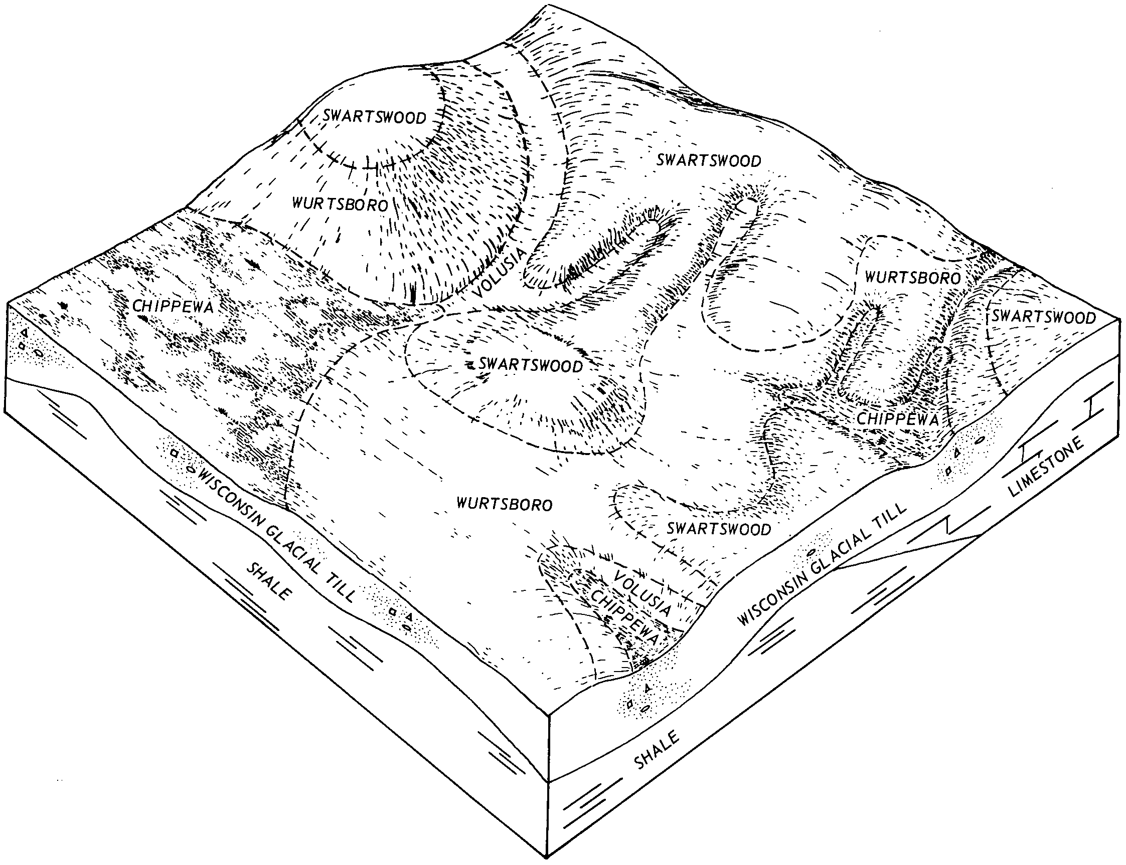
Wurtsboro-Swartswood complex, 8 to 15 percent slopes, extremely stony | WusCc | 8072 | 298051 | b04k | nj037 | 2002 | 1:24000 |
Wurtsboro-Swartswood complex, 0 to 8 percent slopes, extremely stony | WusBc | 7843 | 298050 | b04j | nj037 | 2002 | 1:24000 |
Swartswood loam, 0 to 8 percent slopes, extremely stony | SwfBc | 3598 | 298221 | b0b1 | nj037 | 2002 | 1:24000 |
Wurtsboro-Swartswood complex, 15 to 35 percent slopes, extremely stony | WusDc | 3572 | 614075 | nlzw | nj037 | 2002 | 1:24000 |
Urban land-Wurtsboro-Swartswood complex, 0 to 8 percent slopes | USWUSB | 66 | 723869 | s97m | nj037 | 2002 | 1:24000 |
Wurtsboro-Swartswood complex, 8 to 15 percent slopes, extremely stony | WusCc | 5428 | 1147502 | 17j26 | nj041 | 2007 | 1:12000 |
Wurtsboro-Swartswood complex, 15 to 35 percent slopes, extremely stony | WusDc | 3379 | 1147533 | 17j36 | nj041 | 2007 | 1:12000 |
Wurtsboro-Swartswood complex, 0 to 8 percent slopes, extremely stony | WusBc | 2533 | 1147501 | 17j25 | nj041 | 2007 | 1:12000 |
Swartswood loam, 15 to 35 percent slopes, extremely stony | SwfDc | 250 | 298413 | b0j7 | nj041 | 2007 | 1:12000 |
Swartswood loam, 8 to 15 percent slopes, extremely stony | SwfCc | 52 | 298411 | b0j5 | nj041 | 2007 | 1:12000 |
Swartswood loam, 0 to 8 percent slopes, extremely stony | SwfBc | 18 | 298409 | b0j3 | nj041 | 2007 | 1:12000 |
Swartswood and Mardin soils, sloping, very stony | SXC | 36565 | 293979 | 2v30r | ny071 | 1976 | 1:15840 |
Swartswood and Mardin soils, moderately steep, very stony | SXD | 6163 | 293980 | 2v30s | ny071 | 1976 | 1:15840 |
Swartswood gravelly loam, 3 to 8 percent slopes | SwB | 2471 | 293976 | 9vx3 | ny071 | 1976 | 1:15840 |
Swartswood gravelly loam, 8 to 15 percent slopes | SwC | 1777 | 293977 | 9vx4 | ny071 | 1976 | 1:15840 |
Swartswood gravelly loam, 15 to 25 percent slopes | SwD | 681 | 293978 | 9vx5 | ny071 | 1976 | 1:15840 |
Swartswood and Mardin soils, very steep, very stony | SXF | 419 | 293981 | 2v30t | ny071 | 1976 | 1:15840 |
Swartswood and Lackawanna soils, steep, extremely stony | SwE | 21494 | 295133 | 2w0bw | ny105 | 1984 | 1:15840 |
Swartswood gravelly loam, 3 to 8 percent slopes, stony | SrB | 8269 | 295129 | 9x39 | ny105 | 1984 | 1:15840 |
Swartswood gravelly loam, 8 to 15 percent slopes, stony | SrC | 6143 | 295130 | 9x3b | ny105 | 1984 | 1:15840 |
Swartswood gravelly loam, 15 to 25 percent slopes, stony | SrD | 2394 | 295131 | 9x3c | ny105 | 1984 | 1:15840 |
Swartswood and Lackawanna soils, very steep, extremely stony | SwF | 2151 | 295134 | 2w0bx | ny105 | 1984 | 1:15840 |
Swartswood and Lackawanna soils, 25 to 35 percent slopes, very stony | StE | 1807 | 295132 | 2w0bm | ny105 | 1984 | 1:15840 |
Lackawanna and Swartswood soils, moderately steep, very bouldery | LCD | 24795 | 295492 | 2w09r | ny111 | 1974 | 1:15840 |
Lackawanna and Swartswood soils, steep, extremely bouldery | LEE | 13405 | 295494 | 2w09t | ny111 | 1974 | 1:15840 |
Lackawanna and Swartswood soils, very steep, very bouldery | LCF | 11160 | 295493 | 2w09s | ny111 | 1974 | 1:15840 |
Swartswood stony fine sandy loam, 3 to 8 percent slopes | SwB | 409 | 295546 | 9xjr | ny111 | 1974 | 1:15840 |
Swartswood stony fine sandy loam, 8 to 15 percent slopes | SwC | 226 | 295547 | 9xjs | ny111 | 1974 | 1:15840 |
Swartswood very stony loam, 0 to 8 percent slopes | SwB | 2341 | 539412 | l39d | pa025 | 1960 | 1:20000 |
Swartswood very stony loam, 8 to 25 percent slopes | SwD | 1091 | 539413 | l39f | pa025 | 1960 | 1:20000 |
Swartswood channery silt loam, 0 to 8 percent slopes | SsB | 109 | 539410 | l39b | pa025 | 1960 | 1:20000 |
Swartswood channery silt loam, 8 to 15 percent slopes, moderately eroded | SsC2 | 13 | 539411 | l39c | pa025 | 1960 | 1:20000 |
Swartswood extremely stony loam, 8 to 25 percent slopes | SxD | 4804 | 299341 | b1h5 | pa069 | 1976 | 1:20000 |
Swartswood extremely stony loam, 3 to 8 percent slopes | SxB | 2369 | 299340 | b1h4 | pa069 | 1976 | 1:20000 |
Swartswood channery loam, 3 to 8 percent slopes | SwB | 1022 | 299337 | b1h1 | pa069 | 1976 | 1:20000 |
Swartswood channery loam, 8 to 15 percent slopes | SwC | 889 | 299338 | b1h2 | pa069 | 1976 | 1:20000 |
Swartswood channery loam, 15 to 25 percent slopes | SwD | 449 | 299339 | b1h3 | pa069 | 1976 | 1:20000 |
Swartswood extremely stony loam, 8 to 25 percent slopes | SxD | 83 | 1423091 | 1jrv5 | pa079 | 1974 | 1:20000 |
Swartswood extremely stony loam, 3 to 8 percent slopes | SxB | 29 | 1423090 | 1jrv4 | pa079 | 1974 | 1:20000 |
Swartswood channery loam, 15 to 25 percent slopes | SwD | 5 | 1423089 | 1jrv3 | pa079 | 1974 | 1:20000 |
Swartswood very stony sandy loam, 8 to 25 percent slopes | SxD | 1786 | 539118 | l2zx | pa081 | 1981 | 1:20000 |
Swartswood extremely stony sandy loam, 0 to 8 percent slopes | SxB | 12385 | 296360 | 9yd0 | pa089 | 1975 | 1:20000 |
Swartswood extremely stony sandy loam, 8 to 25 percent slopes | SxC | 4654 | 296361 | 9yd1 | pa089 | 1975 | 1:20000 |
Swartswood channery sandy loam, 3 to 8 percent slopes | SwB | 723 | 296358 | 9ycy | pa089 | 1975 | 1:20000 |
Swartswood channery sandy loam, 8 to 15 percent slopes | SwC | 483 | 296359 | 9ycz | pa089 | 1975 | 1:20000 |
Swartswood gravelly loam, 3 to 8 percent slopes | SvB | 3878 | 543327 | l7cp | pa095 | 2007 | 1:12000 |
Swartswood and Wurtsboro soils, 0 to 8 percent slopes, extremely stony | SwB | 2632 | 543330 | l7cs | pa095 | 2007 | 1:12000 |
Swartswood gravelly loam, 8 to 15 percent slopes | SvC | 1407 | 543328 | l7cq | pa095 | 2007 | 1:12000 |
Swartswood and Wurtsboro soils, 8 to 25 percent slopes, extremely stony | SwD | 1359 | 543331 | l7ct | pa095 | 2007 | 1:12000 |
Urban land-Swartswood complex, 0 to 8 percent slopes | UsB | 1028 | 1948979 | 23f29 | pa095 | 2007 | 1:12000 |
Urban land-Swartswood complex, 8 to 25 percent slopes | UsD | 394 | 1948980 | 23f2b | pa095 | 2007 | 1:12000 |
Swartswood gravelly loam, 15 to 25 percent slopes | SvD | 246 | 543329 | l7cr | pa095 | 2007 | 1:12000 |
Swartswood stony fine sandy loam, 0 to 8 percent slopes, extremely stony | 38B | 30294 | 297224 | 9z8w | pa103 | 1995 | 1:24000 |
Lordstown-Swartswood complex, 0 to 8 percent slopes, extremely stony | 897B | 12973 | 297244 | 9z9j | pa103 | 1995 | 1:24000 |
Swartswood stony fine sandy loam, 8 to 15 percent slopes, extremely stony | 38C | 11009 | 297225 | 9z8x | pa103 | 1995 | 1:24000 |
Lordstown-Swartswood complex, 8 to 15 percent slopes, extremely stony | 897C | 8089 | 297245 | 9z9k | pa103 | 1995 | 1:24000 |
Swartswood stony fine sandy loam, 15 to 30 percent slopes, extremely stony | 38D | 3268 | 297226 | 9z8y | pa103 | 1995 | 1:24000 |
Lordstown-Swartswood complex, 15 to 30 percent slopes, extremely stony | 897D | 2311 | 297246 | 9z9l | pa103 | 1995 | 1:24000 |
Swartswood extremely stony loam, 8 to 25 percent slopes | SxD | 4 | 319832 | bqt5 | pa115 | 1968 | 1:20000 |
Swartswood extremely stony sandy loam, 3 to 8 percent slopes | SxB | 4229 | 296627 | 9ynm | pa127 | 1977 | 1:20000 |
Swartswood extremely stony sandy loam, 8 to 25 percent slopes | SxD | 3372 | 296628 | 9ynn | pa127 | 1977 | 1:20000 |
Swartswood channery sandy loam, 3 to 8 percent slopes | SwB | 1146 | 296624 | 9ynj | pa127 | 1977 | 1:20000 |
Swartswood channery sandy loam, 8 to 15 percent slopes | SwC | 870 | 296625 | 9ynk | pa127 | 1977 | 1:20000 |
Swartswood channery sandy loam, 15 to 25 percent slopes | SwD | 250 | 296626 | 9ynl | pa127 | 1977 | 1:20000 |
Swartswood extremely stony loam, 8 to 25 percent slopes | SxD | 412 | 301970 | b46z | pa131 | 1976 | 1:20000 |
Swartswood channery loam, 15 to 25 percent slopes | SwD | 176 | 301968 | b46x | pa131 | 1976 | 1:20000 |
Swartswood extremely stony loam, 3 to 8 percent slopes | SxB | 163 | 301969 | b46y | pa131 | 1976 | 1:20000 |
Swartswood channery loam, 8 to 15 percent slopes | SwC | 140 | 301967 | b46w | pa131 | 1976 | 1:20000 |
Swartswood channery loam, 3 to 8 percent slopes | SwB | 63 | 301966 | b46v | pa131 | 1976 | 1:20000 |
Swartswood extremely stony loam, 3 to 8 percent slopes | SxB | 75 | 1452546 | 1krhb | pa610 | 1978 | 1:20000 |
Swartswood extremely stony loam, 8 to 25 percent slopes | SxD | 1 | 1452547 | 1krhc | pa610 | 1978 | 1:20000 |


