| Surrency sand | 16 | 8419 | 320675 | brpc | fl001 | 1982 | 1:15840 |
Mascotte, Wesconnett, and Surrency soils, flooded | 80 | 4066 | 320786 | brsy | fl001 | 1982 | 1:15840 |
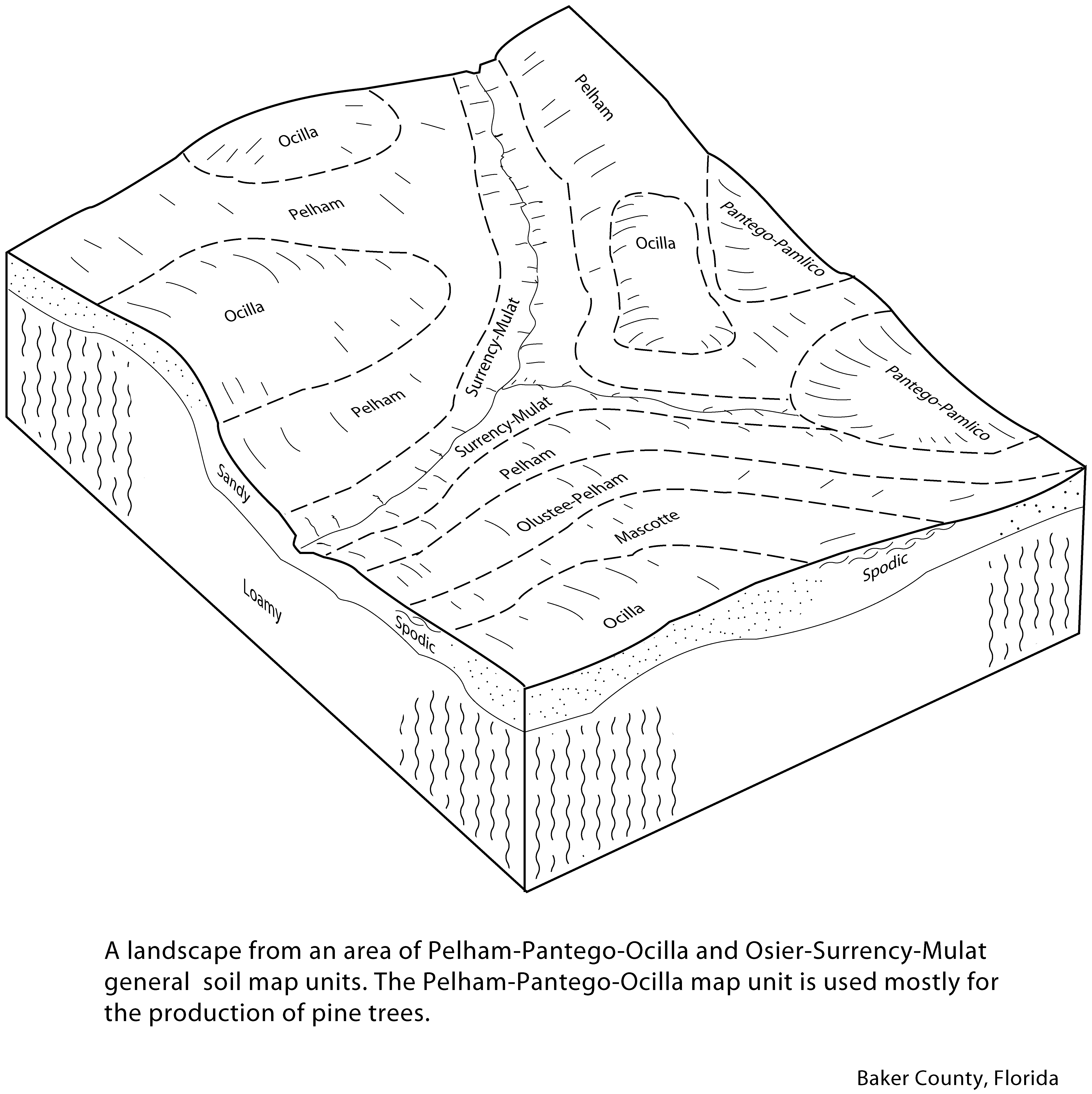
Surrency-Mulat complex, frequently flooded | 18 | 7705 | 1444876 | 1khhx | fl003 | 1991 | 1:20000 |
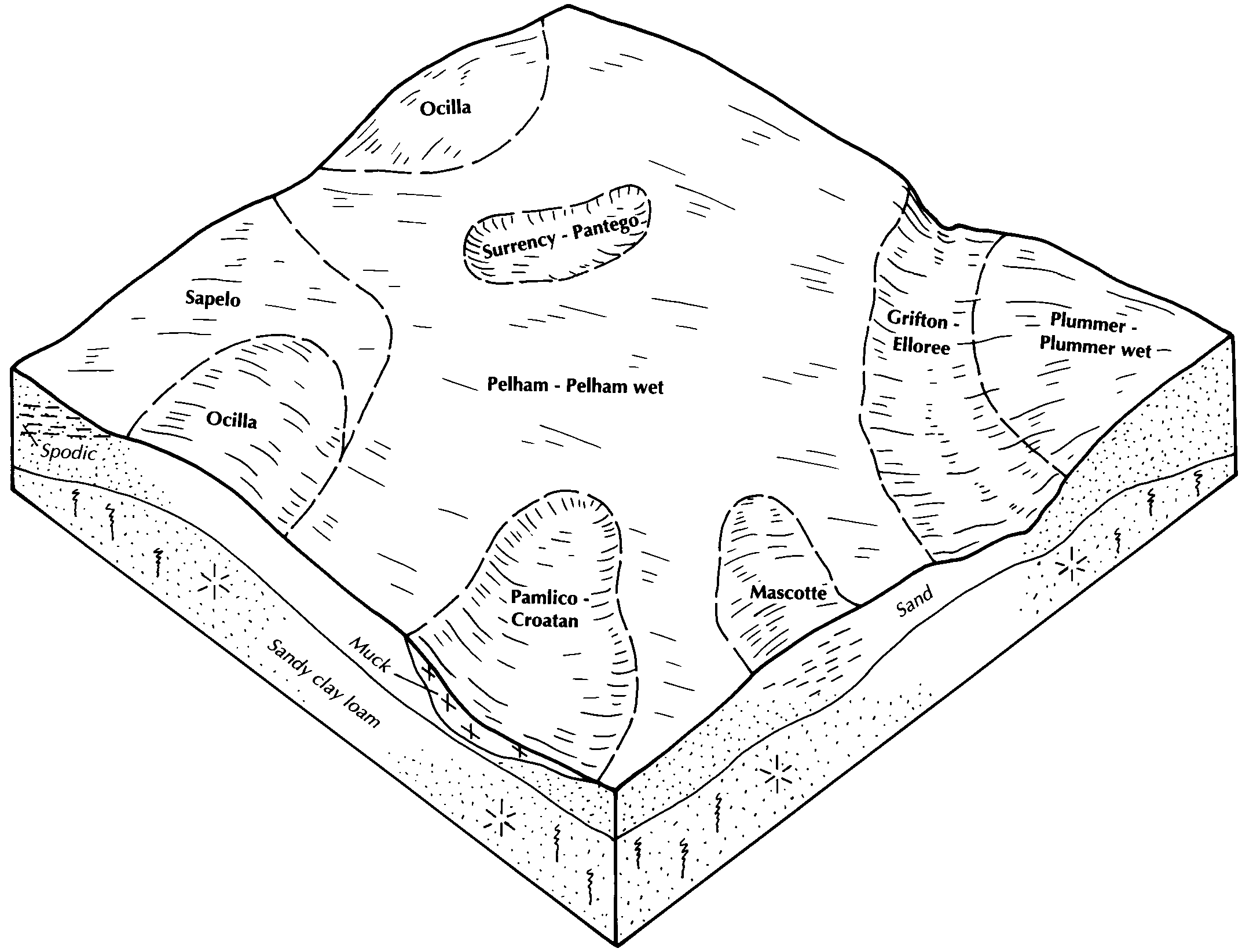
Surrency and Pantego soils, depressional | 7 | 13153 | 631619 | p67t | fl007 | 1988 | 1:15840 |
Surrency and Pantego soils, frequently flooded | 8 | 3307 | 631620 | p67v | fl007 | 1988 | 1:15840 |
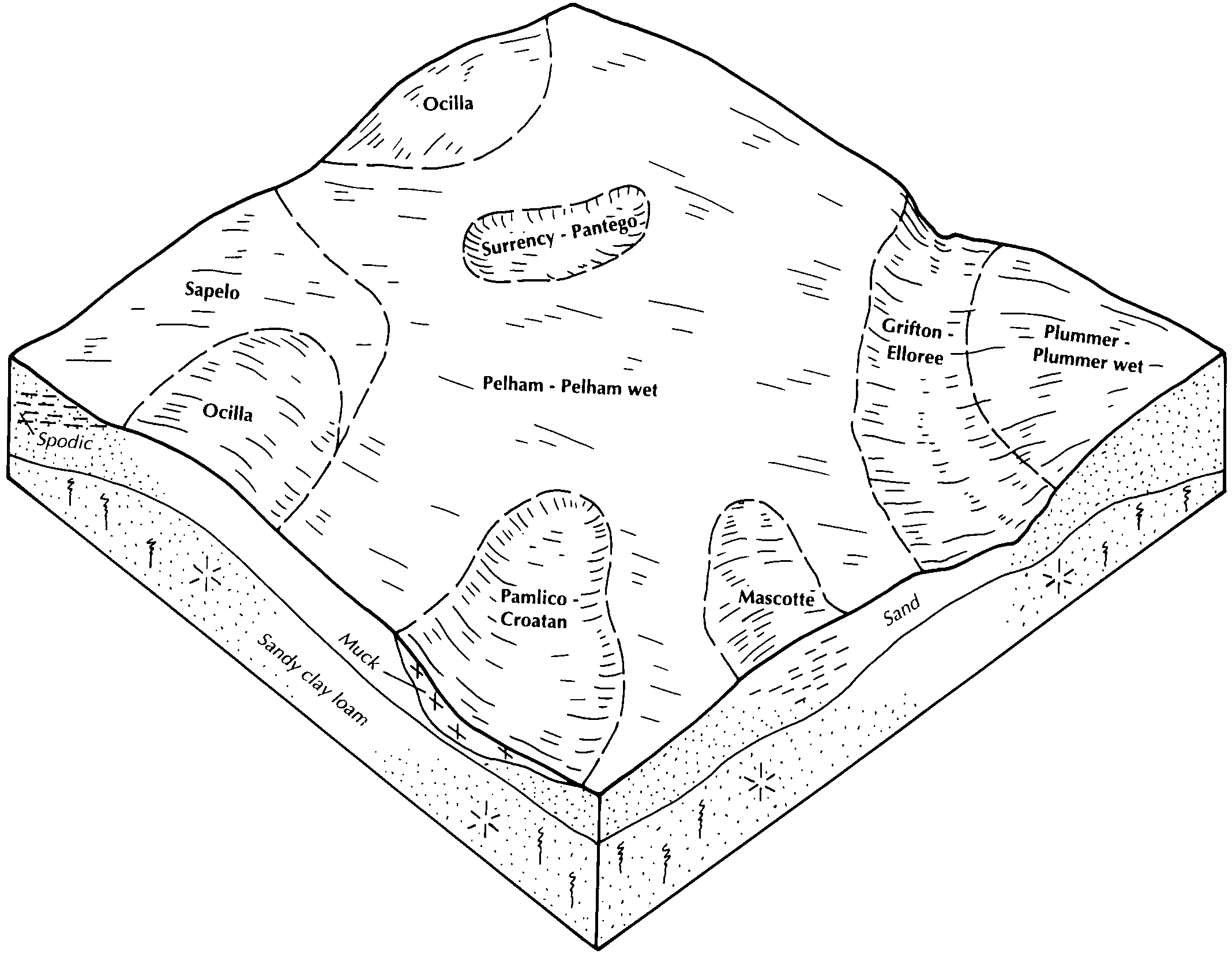
Croatan, Surrency, and Pantego soils, depressional | 54 | 33661 | 1481039 | 1lq4g | fl013 | 1997 | 1:20000 |
Croatan, Kinston, and Surrency soils, frequently flooded | 68 | 16031 | 1481053 | 1lq4x | fl013 | 1997 | 1:20000 |
Croatan, Rutlege, and Surrency soils, depressional | 60 | 6962 | 1481045 | 1lq4n | fl013 | 1997 | 1:20000 |
Surrency fine sand, depressional | 12 | 2210 | 132802 | 4g5y | fl019 | 1986 | 1:24000 |
Surrency fine sand, frequently flooded | 38 | 1575 | 132827 | 4g6r | fl019 | 1986 | 1:24000 |
Surrency fine sand | 57 | 41940 | 797480 | vrv5 | fl023 | 1981 | 1:24000 |
Surrency fine sand, occasionally flooded | 58 | 4120 | 797481 | vrv6 | fl023 | 1981 | 1:24000 |
Surrency loamy fine sand, depressional, 0 to 2 percent slopes | 66 | 25420 | 738878 | ssvs | fl031 | 1996 | 1:24000 |
Surrency loamy fine sand, 0 to 2 percent slopes, frequently flooded | 67 | 4870 | 738879 | ssvt | fl031 | 1996 | 1:24000 |
Surrency fine sand | 34 | 10381 | 1477087 | 1ll0z | fl037 | 1990 | 1:20000 |
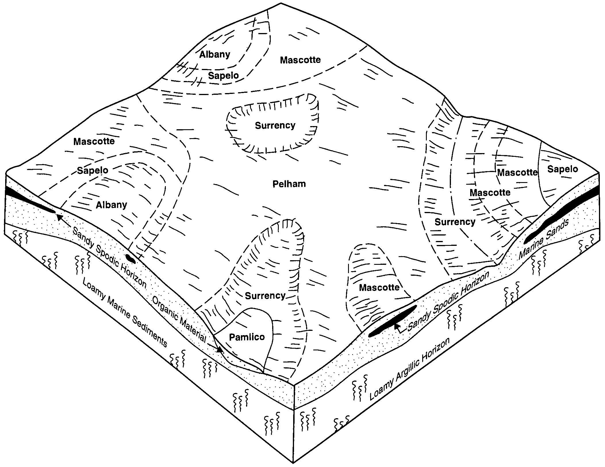
Rutlege, Bibb, and Surrency soils, frequently flooded | 88 | 9368 | 1381627 | 1hcpm | fl039 | 2006 | 1:12000 |
Surrency mucky fine sand, depressional | 26 | 1060 | 321808 | bsvx | fl041 | 1989 | 1:20000 |
Surrency mucky fine sand, depressional | 39 | 16514 | 1472760 | 1lfjd | fl045 | 1997 | 1:24000 |
Croatan-Surrency complex, frequently flooded | 45 | 15440 | 1472765 | 1lfjk | fl045 | 1997 | 1:24000 |
Plummer and Surrency soils, depressional | 21 | 25450 | 1148817 | 17kfm | fl047 | 1995 | 1:24000 |
Surrency fine sand | 4 | 32600 | 700467 | rhwq | fl065 | 1984 | 1:20000 |
Surrency, Plummer, and Clara soils, depressional | 18 | 5300 | 886573 | yrk4 | fl067 | 1993 | 1:24000 |
Sapelo, low-Clara-Surrency, depressional complex | 42 | 3620 | 886600 | yrl0 | fl067 | 1993 | 1:24000 |
Pantego and Surrency soils, depressional | 37 | 900 | 886595 | yrkv | fl067 | 1993 | 1:24000 |
Pantego and Surrency soils, frequently flooded | 38 | 830 | 886596 | yrkw | fl067 | 1993 | 1:24000 |
Surrency fine sand | 46 | 3820 | 1454456 | 1ktgy | fl073 | 1989 | 1:20000 |
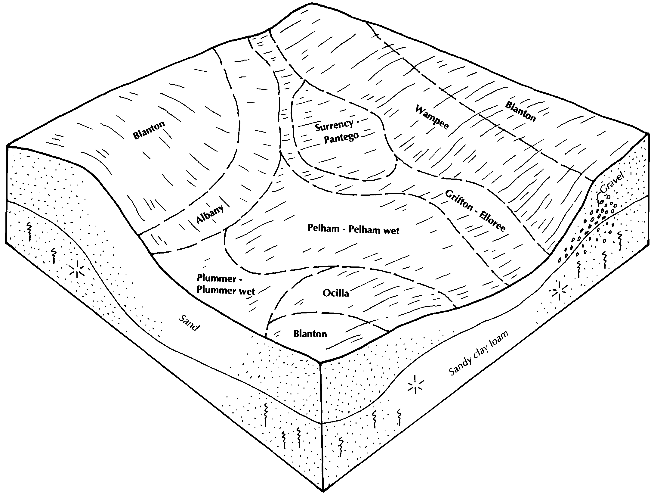
Rutlege, Bibb and Surrency soils, 0 to 2 percent slopes, frequently flooded | 58 | 47040 | 322748 | 2xcy8 | fl077 | 2004 | 1:24000 |
Surrency, Pantego, and Croatan soils, depressional | 57 | 25605 | 322747 | btv6 | fl077 | 2004 | 1:24000 |
Plummer and Surrency soils, depressional | 48 | 41760 | 1380318 | 1hbbd | fl079 | 1988 | 1:15840 |
Surrency, Plummer, and Cantey soils, frequently flooded | 77 | 7310 | 1380343 | 1hbc6 | fl079 | 1988 | 1:15840 |
Surrency fine sand, depressional | 51 | 990 | 323418 | bvjv | fl107 | 1985 | 1:15840 |
Surrency, Plummer, and Cantey soils, frequently flooded | 74 | 965 | 1023388 | 13bxj | fl121 | 2003 | 1:24000 |
Surrency, Starke, and Croatan soils, depressional | 28 | 16670 | 1425222 | 1jv1x | fl123 | 1998 | 1:24000 |
Albany-Surrency, depressional, complex, 0 to 3 percent slopes | 29 | 1800 | 1425223 | 1jv1y | fl123 | 1998 | 1:24000 |
Surrency and Pantego soils, depressional | 7 | 9880 | 1414612 | 1jh0n | fl125 | 1989 | 1:15840 |
Surrency and Pantego soils, frequently flooded | 8 | 2110 | 1414613 | 1jh0p | fl125 | 1989 | 1:15840 |
Surrency mucky fine sand | 39 | 10430 | 1399066 | 1hyv5 | fl129 | 1988 | 1:24000 |
Surrency mucky sand, 0 to 1 percent slopes, frequently flooded | SuA | 41215 | 1701112 | 1v34l | ga103 | 2007 | 1:24000 |
Surrency mucky sand, 0 to 1 percent slopes, frequently flooded | SuA | 14370 | 2580381 | 2qdyc | ga251 | 2011 | 1:24000 |
Surrency mucky fine sand, frequently ponded, 0 to 1 percent slopes | SuA | 73190 | 2408378 | 2wb8w | ga299 | 2008 | 1:24000 |
Croatan, Pamlico, and Surrency soils, ponded, 0 to 1 percent slopes, rarely flooded | CPA | 24670 | 2408351 | 2lv2r | ga299 | 2008 | 1:24000 |
Surrency loamy sand | Sv | 34725 | 125147 | 4670 | ga601 | 1969 | 1:20000 |
Surrency loamy sand, ponded | Su | 42335 | 125185 | 4687 | ga602 | 1983 | 1:20000 |
Surrency mucky fine sand, frequently ponded, 0 to 1 percent slopes | SuA | 58440 | 2686760 | 2wb8w | ga611 | 2012 | 1:24000 |
Croatan, Pamlico and Surrency soils, ponded, 0 to 1 percent slopes, rarely flooded | CPA | 10775 | 2686754 | 2rz85 | ga611 | 2012 | 1:24000 |
Surrency mucky fine sand, frequently ponded, 0 to 1 percent slopes | SuA | 208713 | 2686816 | 2wb8w | ga626 | 2013 | 1:24000 |
Croatan, Pamlico and Surrency soils, ponded, 0 to 1 percent slopes, rarely flooded | CPA | 11339 | 2686802 | 2rz85 | ga626 | 2013 | 1:24000 |