Official Series Description


Lab Data Summary

Aggregate lab data for the SUNEV soil series. This aggregation is based on all pedons with a current taxon name of SUNEV, and applied along 1-cm thick depth slices. Solid lines are the slice-wise median, bounded on either side by the interval defined by the slice-wise 5th and 95th percentiles. The median is the value that splits the data in half. Five percent of the data are less than the 5th percentile, and five percent of the data are greater than the 95th percentile. Values along the right hand side y-axis describe the proportion of pedon data that contribute to aggregate values at this depth. For example, a value of "90%" at 25cm means that 90% of the pedons correlated to SUNEV were used in the calculation. Source: KSSL snapshot . Methods used to assemble the KSSL snapshot used by SoilWeb / SDE

There are insufficient data to create the lab data summary figure.


Water Balance

Monthly water balance estimated using a leaky-bucket style model for the SUNEV soil series. Monthly precipitation (PPT) and potential evapotranspiration (PET) have been estimated from the 50th percentile of gridded values (PRISM 1981-2010) overlapping with the extent of SSURGO map units containing each series as a major component. Monthly PET values were estimated using the method of Thornthwaite (1948). These (and other) climatic parameters are calculated with each SSURGO refresh and provided by the fetchOSD function of the soilDB package. Representative water storage values (“AWC” in the figures) were derived from SSURGO by taking the 50th percentile of profile-total water storage (sum[awc_r * horizon thickness]) for each soil series. Note that this representation of “water storage” is based on the average ability of most plants to extract soil water between 15 bar (“permanent wilting point”) and 1/3 bar (“field capacity”) matric potential. Soil moisture state can be roughly interpreted as “dry” when storage is depleted, “moist” when storage is between 0mm and AWC, and “wet” when there is a surplus. Clearly there are a lot of assumptions baked into this kind of monthly water balance. This is still a work in progress.

Click the image to view it full size.


Click the image to view it full size.

Sibling Summary

Siblings are those soil series that occur together in map units, in this case with the SUNEV series. Sketches are arranged according to their subgroup-level taxonomic structure. Source: SSURGO snapshot , parsed OSD records and snapshot of SC database .

Click the image to view it full size.

Select annual climate data summaries for the SUNEV series and siblings. Series are sorted according to hierarchical clustering of median values. Source: SSURGO map unit geometry and 1981-2010, 800m PRISM data .

Click the image to view it full size.

Geomorphic description summaries for the SUNEV series and siblings. Series are sorted according to hierarchical clustering of proportions and relative hydrologic position within an idealized landform (e.g. top to bottom). Most soil series (SSURGO components) are associated with a hillslope position and one or more landform-specific positions: hills, mountain slopes, terraces, and/or flats. Proportions can be interpreted as an aggregate representation of geomorphic membership. The values printed to the left (number of component records) and right (Shannon entropy) of stacked bars can be used to judge the reliability of trends. Small Shannon entropy values suggest relatively consistent geomorphic association, while larger values suggest lack thereof. Source: SSURGO component records .

Click the image to view it full size.

Click the image to view it full size.

There are insufficient data to create the 3D mountains figure.

Click the image to view it full size.

There are insufficient data to create the 3D flats position figure.

Competing Series

Soil series competing with SUNEV share the same family level classification in Soil Taxonomy. Source: parsed OSD records and snapshot of the SC database .

Click the image to view it full size.

Select annual climate data summaries for the SUNEV series and competing. Series are sorted according to hierarchical clustering of median values. Source: SSURGO map unit geometry and 1981-2010, 800m PRISM data .

Click the image to view it full size.

Geomorphic description summaries for the SUNEV series and competing. Series are sorted according to hierarchical clustering of proportions and relative hydrologic position within an idealized landform (e.g. top to bottom). Proportions can be interpreted as an aggregate representation of geomorphic membership. Most soil series (SSURGO components) are associated with a hillslope position and one or more landform-specific positions: hills, mountain slopes, terraces, and/or flats. The values printed to the left (number of component records) and right (Shannon entropy) of stacked bars can be used to judge the reliability of trends. Shannon entropy values close to 0 represent soil series with relatively consistent geomorphic association, while values close to 1 suggest lack thereof. Source: SSURGO component records .

Click the image to view it full size.

Click the image to view it full size.

There are insufficient data to create the 3D mountains figure.

Click the image to view it full size.

There are insufficient data to create the 3D flats position figure.

Soil series sharing subgroup-level classification with SUNEV, arranged according to family differentiae. Hovering over a series name will print full classification and a small sketch from the OSD. Source: snapshot of SC database .

Block Diagrams

Click a link below to display the diagram. Note that these diagrams may be from multiple survey areas.

  1. TX-2010-11-03-51 | Lampasas County - 1991

    Typical pattern of soils and underlying material in the Sunev-Rumley-Oakalla general soil map unit (Soil Survey of Lampasas County, Texas; 1991).

  2. TX-2010-11-03-75 | Mason County -

  3. TX-2010-11-04-09 | Milam County - 2004

    Typical pattern of soils and underlying material in the Branyon-Burleson general soil map unit (Soil Survey of Milam County, Texas; 2004).

  4. TX-2012-03-20-21 | Comal and Hays Counties - June 1984

    Pattern of soils in the Brackett-Comfort-Real general soil map unit (Soil Survey of Comal and Hays Counties, TX; 1984).

  5. TX-2012-03-20-24 | Comal and Hays Counties - June 1984

    Pattern of soils in the Lewisville-Gruene-Krum and Branyon-Krum general soil map units (Soil Survey of Comal and Hays Counties, TX; 1984).

  6. TX-2012-03-22-12 | Williamson County - January 1983

    Typical landscape pattern of the Oakalla-Sunev and the Denton-Eckrant-Doss general soil map units (Soil Survey of Williamson County, TX; 1983).

Map Units

Map units containing SUNEV as a major component. Limited to 250 records.

Map Unit Name Symbol Map Unit Area (ac) Map Unit Key National Map Unit Symbol Soil Survey Area Publication Date Map Scale
Sunev loam, 2 to 5 percent slopesSvC160331300602s1r9tx02719721:24000
Queeny-Sunev complex, 5 to 15 percent slopesQuF107031300622s1rbtx02719721:24000
Sunev silty clay loam, 0 to 1 percent slopesSvA11031300612s1qhtx02719721:24000
Sunev clay loam, 1 to 3 percent slopesVcB13301390511f3c4tx02920001:24000
Sunev clay loam, 0 to 1 percent slopesVcA12509390510f3c3tx02920001:24000
Gullied land-Sunev complex, 3 to 20 percent slopesGu3853390466f39ptx02920001:24000
Sunev loam, 1 to 3 percent slopesVaB2340390509f3c2tx02920001:24000
Sunev clay loam, 3 to 5 percent slopesVcC1117390512f3c5tx02920001:24000
Sunev loam, 0 to 1 percent slopesVaA1084390508f3c1tx02920001:24000
Sunev clay loam, cool, 1 to 3 percent slopesSuB171663630252tc49tx03519771:24000
Sunev clay loam, 0 to 1 percent slopesSuA571363024d5rgtx03519771:24000
Sunev clay loam, cool, 3 to 5 percent slopesSuC82093644122tc4btx09319741:20000
Sunev clay loam, cool, 5 to 8 percent slopesSuD30863644132tc4ctx09319741:20000
Sunev clay loam, 3 to 8 percent slopes711580364857d7nltx11319751:20000
Sunev clay loam, 1 to 3 percent slopes70309364856d7nktx11319751:20000
Sunev loam, 3 to 5 percent slopesSyC2250366552d9f8tx17719971:24000
Sunev loam, 8 to 15 percent slopesSyE2041366553d9f9tx17719971:24000
Sunev loam, 0 to 1 percent slopesSuA6072366874d9rntx18719731:20000
Sunev loam, 1 to 3 percent slopesSuB2423366875d9rptx18719731:20000
Sunev loam, 3 to 5 percent slopes, erodedSuC31824366876d9rqtx18719731:20000
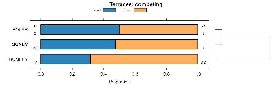
Bolar-Sunev complex, 3 to 5 percent slopes195144367730dbn8tx21719751:20000
Sunev clay loam, 5 to 15 percent slopes722667367789dbq5tx21719751:20000
Sunev clay loam, cool, 3 to 5 percent slopesSuC19693682142tc4btx25119811:20000
Sunev clay loam, cool, 1 to 3 percent slopesSuB9493682132tc49tx25119811:20000
Sunev silty clay loam, 0 to 2 percent slopesSuA1635368539dchctx26519831:31680
Sunev loam, rarely floodedSuA16747368884dcvhtx28119901:24000
Sunev loam, 1 to 3 percent slopesSuB2250368885dcvjtx28119901:24000
Sunev clay loam, cool, 1 to 3 percent slopesSzB37283701312tc49tx30919921:24000
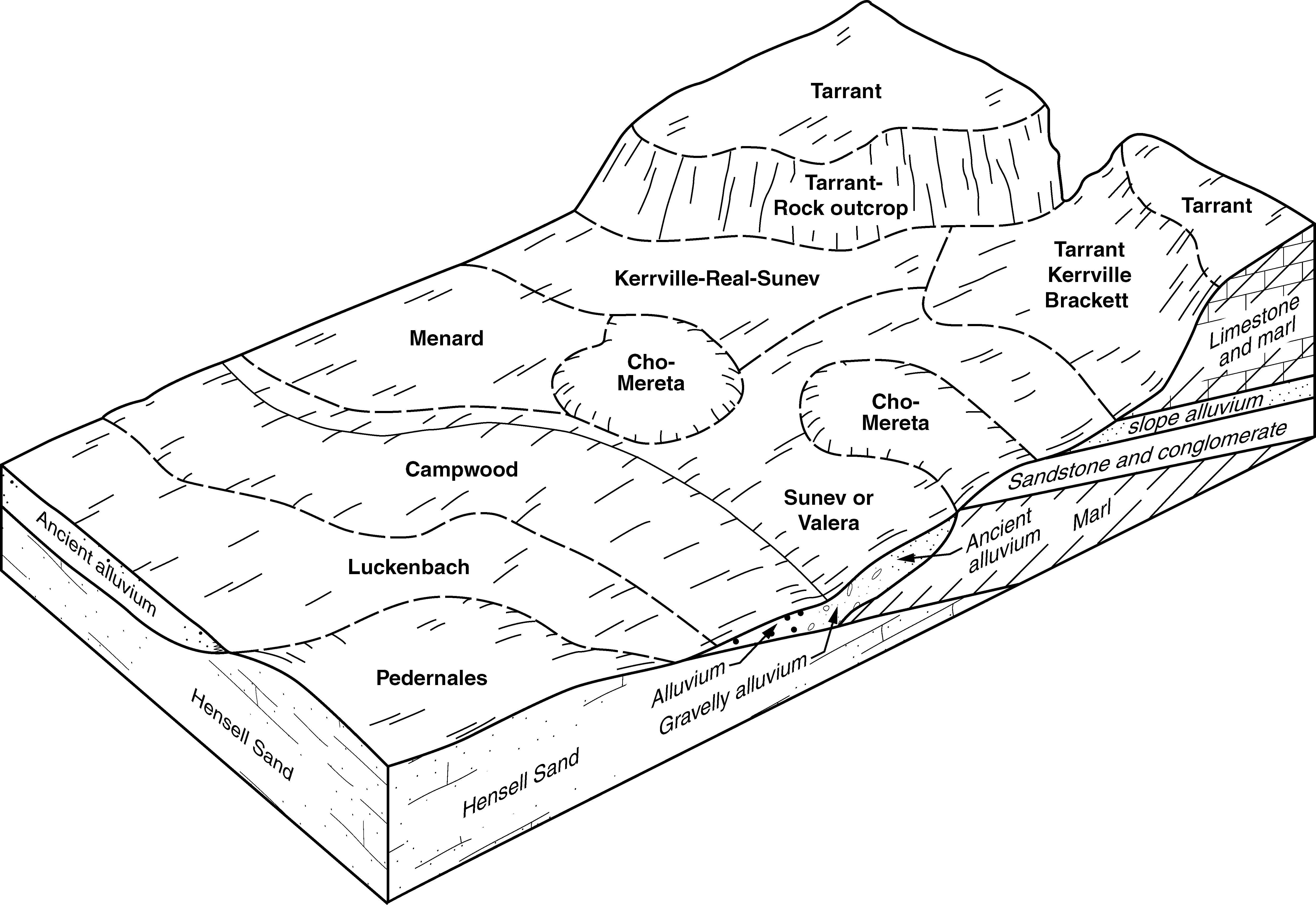
Mereta-Cho-Sunev complex, 0 to 5 percent slopes, rockyMSC19751370430dfgctx31920111:24000
Campwood, Sunev, and Valera soils, 0 to 5 percent slopesCAC16667370437dfgltx31920111:24000
Sunev clay loam, 1 to 8 percent slopesSuD7503370400dffdtx31920111:24000
Kerrville, Real, and Sunev soils, 1 to 12 percent slopesKVE1932370409dffptx31920111:24000
Sunev loam, 2 to 5 percent slopesSvC24673706982s1r9tx33119881:24000
Queeny-Sunev complex, 5 to 15 percent slopesQuF25231300902s1rbtx33119881:24000
Sunev clay loam, 3 to 8 percent slopesSuC7279372428dhjttx43919791:20000
Sunev-Urban land complex, 2 to 8 percent slopesSvC2797372429dhjvtx43919791:20000
Sunev clay loam, cool, 1 to 3 percent slopesSuB14323724272tc49tx43919791:20000
Sunev silty clay loam, 1 to 3 percent slopesSvB8070373573djqrtx49119811:20000
Queeny-Sunev complex, 5 to 15 percent slopesQuF267031301232s1rbtx49119811:20000
Sunev silty clay loam, 0 to 1 percent slopesSvA14433735722s1qhtx49119811:20000
Sunev loam, 2 to 5 percent slopesSvC62331301222s1r9tx49119811:20000
Sunev clay loam, cool, 1 to 3 percent slopes72296453910512tc49tx60219751:24000
Sunev clay loam, 1 to 3 percent slopesSuB9476393651f6mftx60419811:20000
Sunev silty clay loam, 0 to 1 percent slopesSuA2481393650f6mdtx60419811:20000
Sunev clay loam, cool, 3 to 5 percent slopesSuC285843743592tc4btx60919751:20000
Sunev clay loam, cool, 5 to 8 percent slopesSuD59233743602tc4ctx60919751:20000

Map of Series Extent

Approximate geographic distribution of the SUNEV soil series. To learn more about how this distribution was mapped, or to compare this soil series extent to others, use the Series Extent Explorer (SEE) application. Source: generalization of SSURGO geometry .