| Clarion-Sunburg complex, 9 to 14 percent slopes, moderately eroded | 641D2 | 1814 | 406578 | fn2f | ia081 | 1987 | 1:15840 |
Clarion-Sunburg complex, 5 to 9 percent slopes, moderately eroded | 641C2 | 1038 | 406577 | fn2d | ia081 | 1987 | 1:15840 |
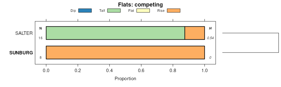
Sunburg sandy loam, 9 to 14 percent slopes, moderately eroded | 640D2 | 764 | 406573 | fn28 | ia081 | 1987 | 1:15840 |
Clarion-Sunburg complex, 14 to 18 percent slopes, moderately eroded | 641E2 | 671 | 406579 | fn2g | ia081 | 1987 | 1:15840 |
Sunburg sandy loam, 5 to 9 percent slopes, moderately eroded | 640C2 | 570 | 406572 | fn27 | ia081 | 1987 | 1:15840 |
Clarion-Sunburg complex, 2 to 5 percent slopes | 641B | 376 | 406576 | fn2c | ia081 | 1987 | 1:15840 |
Sunburg sandy loam, 14 to 18 percent slopes, moderately eroded | 640E2 | 310 | 406574 | fn29 | ia081 | 1987 | 1:15840 |
Sunburg-Salida complex, 9 to 14 percent slopes, moderately eroded | 642D2 | 223 | 406580 | fn2h | ia081 | 1987 | 1:15840 |
Sunburg sandy loam, 18 to 25 percent slopes, moderately eroded | 640F2 | 205 | 406575 | fn2b | ia081 | 1987 | 1:15840 |
Wadenill-Sunburg complex, 2 to 6 percent slopes | L337B | 29916 | 2536632 | 2n7zx | mn067 | 1983 | 1:20000 |
Sunburg-Wadenill complex, 6 to 12 percent slopes, moderately eroded | L356C2 | 14513 | 2536643 | 2n7zy | mn067 | 1983 | 1:20000 |
Wadenill-Sunburg-Hawick complex, 2 to 6 percent slopes | L340B | 3689 | 2536634 | 2n802 | mn067 | 1983 | 1:20000 |
Koronis-Sunburg complex, 6 to 12 percent slopes, moderately eroded | L357C2 | 3246 | 2536646 | 2n801 | mn067 | 1983 | 1:20000 |
Sunburg-Wadenill complex, 12 to 18 percent slopes, moderately eroded | L356D2 | 3161 | 2536644 | 2n7zz | mn067 | 1983 | 1:20000 |
Koronis-Sunburg-Hawick complex, 6 to 12 percent slopes, moderately eroded | L355C2 | 2919 | 2536640 | 2n7zw | mn067 | 1983 | 1:20000 |
Koronis-Sunburg complex, 2 to 6 percent slopes | L357B | 2824 | 2536645 | 2n800 | mn067 | 1983 | 1:20000 |
Sunburg-Wadenill-Hawick complex, 6 to 12 percent slopes, moderately eroded | L315C2 | 2704 | 2510836 | 2n803 | mn067 | 1983 | 1:20000 |
Koronis-Sunburg-Hawick complex, 12 to 18 percent slopes, moderately eroded | L355D2 | 2042 | 2536641 | 2n7zh | mn067 | 1983 | 1:20000 |
Sunburg-Wadenill-Hawick complex, 6 to 12 percent slopes | 833C | 1365 | 398724 | fcx2 | mn067 | 1983 | 1:20000 |
Koronis-Sunburg complex, 12 to 18 percent slopes, moderately eroded | L357D2 | 1297 | 2536647 | 2n7zk | mn067 | 1983 | 1:20000 |
Sunburg-Wadenill-Hawick complex, 18 to 35 percent slopes | L315E | 968 | 2510838 | 2n804 | mn067 | 1983 | 1:20000 |
Koronis-Sunburg-Hawick complex, 2 to 6 percent slopes | L355B | 858 | 2536639 | 2n7zv | mn067 | 1983 | 1:20000 |
Koronis-Sunburg-Hawick complex, 18 to 40 percent slopes | L355E | 806 | 2536642 | 2n7zj | mn067 | 1983 | 1:20000 |
Sunburg-Wadenill-Hawick complex, 18 to 35 percent slopes | 833E | 769 | 398726 | fcx4 | mn067 | 1983 | 1:20000 |
Sunburg-Wadenill-Hawick complex, 12 to 18 percent slopes | 833D | 748 | 398725 | fcx3 | mn067 | 1983 | 1:20000 |
Sunburg-Wadenill-Hawick complex, 12 to 18 percent slopes, moderately eroded | L315D2 | 679 | 2510837 | 2n80f | mn067 | 1983 | 1:20000 |
Wadenill-Sunburg-Hawick complex, 2 to 6 percent slopes | 833B | 286 | 398723 | fcx1 | mn067 | 1983 | 1:20000 |
Wadenill-Sunburg complex, 2 to 6 percent slopes | L337B | 5020 | 2536667 | 2n7zx | mn093 | 1996 | 1:20000 |
Sunburg-Wadenill complex, 6 to 12 percent slopes, moderately eroded | L356C2 | 3736 | 2536678 | 2n7zy | mn093 | 1996 | 1:20000 |
Koronis-Sunburg complex, 12 to 18 percent slopes, moderately eroded | L357D2 | 2657 | 2536682 | 2n7zk | mn093 | 1996 | 1:20000 |
Koronis-Sunburg-Hawick complex, 18 to 40 percent slopes | L355E | 1821 | 2536677 | 2n7zj | mn093 | 1996 | 1:20000 |
Koronis-Sunburg-Hawick complex, 6 to 12 percent slopes, moderately eroded | L355C2 | 1099 | 2536675 | 2n7zw | mn093 | 1996 | 1:20000 |
Sunburg-Wadenill complex, 12 to 18 percent slopes, moderately eroded | L356D2 | 784 | 2536679 | 2n7zz | mn093 | 1996 | 1:20000 |
Koronis-Sunburg-Hawick complex, 12 to 18 percent slopes, moderately eroded | L355D2 | 680 | 2536676 | 2n7zh | mn093 | 1996 | 1:20000 |
Wadenill-Sunburg-Hawick complex, 2 to 6 percent slopes | L340B | 575 | 2536669 | 2n802 | mn093 | 1996 | 1:20000 |
Koronis-Sunburg-Hawick complex, 2 to 6 percent slopes | L355B | 559 | 2536674 | 2n7zv | mn093 | 1996 | 1:20000 |
Sunburg-Wadenill complex, 6 to 12 percent slopes, eroded | 805C2 | 379 | 436424 | gn46 | mn093 | 1996 | 1:20000 |
Wadenill-Sunburg complex, 2 to 6 percent slopes | 1391B | 311 | 436233 | gmy1 | mn093 | 1996 | 1:20000 |
Sunburg-Wadenill-Hawick complex, 6 to 12 percent slopes, moderately eroded | L315C2 | 260 | 2536653 | 2n803 | mn093 | 1996 | 1:20000 |
Koronis-Sunburg-Hawick complex, 12 to 18 percent slopes, eroded | 804D2 | 230 | 436420 | gn42 | mn093 | 1996 | 1:20000 |
Koronis-Sunburg-Hawick complex, 18 to 40 percent slopes | 804E | 125 | 436421 | gn43 | mn093 | 1996 | 1:20000 |
Koronis-Sunburg-Hawick complex, 6 to 12 percent slopes, eroded | 804C2 | 70 | 436419 | gn41 | mn093 | 1996 | 1:20000 |
Koronis-Sunburg-Hawick complex, 2 to 6 percent slopes | 804B | 43 | 436418 | gn40 | mn093 | 1996 | 1:20000 |
Sunburg-Wadenill complex, 12 to 18 percent slopes, eroded | 805D2 | 42 | 436425 | gn47 | mn093 | 1996 | 1:20000 |
Sunburg-Wadenill-Hawick complex, 12 to 18 percent slopes, moderately eroded | L315D2 | 33 | 2536654 | 2n80f | mn093 | 1996 | 1:20000 |
Koronis-Sunburg complex, 6 to 12 percent slopes, moderately eroded | L357C2 | 19 | 2536681 | 2n801 | mn093 | 1996 | 1:20000 |
Koronis-Sunburg complex, 2 to 6 percent slopes | L357B | 1 | 2536680 | 2n800 | mn093 | 1996 | 1:20000 |
Koronis-Sunburg complex, 12 to 18 percent slopes, moderately eroded | L357D2 | 1705 | 2536718 | 2n7zk | mn145 | 1980 | 1:15840 |
Koronis-Sunburg-Hawick complex, 12 to 18 percent slopes, moderately eroded | L355D2 | 486 | 2536712 | 2n7zh | mn145 | 1980 | 1:15840 |
Koronis-Sunburg-Hawick complex, 18 to 40 percent slopes | L355E | 475 | 2536713 | 2n7zj | mn145 | 1980 | 1:15840 |
Koronis-Sunburg-Hawick complex, 2 to 6 percent slopes | L355B | 301 | 2536710 | 2n7zv | mn145 | 1980 | 1:15840 |
Koronis-Sunburg-Hawick complex, 6 to 12 percent slopes, moderately eroded | L355C2 | 211 | 2536711 | 2n7zw | mn145 | 1980 | 1:15840 |
Wadenill-Sunburg complex, 2 to 6 percent slopes | L337B | 63 | 2536706 | 2n7zx | mn145 | 1980 | 1:15840 |
Sunburg-Wadenill complex, 12 to 18 percent slopes, moderately eroded | L356D2 | 44 | 2536715 | 2n7zz | mn145 | 1980 | 1:15840 |
Sunburg-Wadenill complex, 6 to 12 percent slopes, moderately eroded | L356C2 | 13 | 2536714 | 2n7zy | mn145 | 1980 | 1:15840 |
Koronis-Sunburg complex, 6 to 12 percent slopes, moderately eroded | L357C2 | 5 | 2536717 | 2n801 | mn145 | 1980 | 1:15840 |
Koronis-Sunburg complex, 2 to 6 percent slopes | L357B | 2 | 2536716 | 2n800 | mn145 | 1980 | 1:15840 |
Koronis-Sunburg complex, 12 to 18 percent slopes, moderately eroded | L357D2 | 427 | 2527623 | 2n7zk | mn171 | 1998 | 1:12000 |
Koronis-Sunburg-Hawick complex, 18 to 40 percent slopes | L355E | 267 | 2536738 | 2n7zj | mn171 | 1998 | 1:12000 |
Koronis-Sunburg-Hawick complex, 6 to 12 percent slopes, moderately eroded | L355C2 | 251 | 2536736 | 2n7zw | mn171 | 1998 | 1:12000 |
Koronis-Sunburg-Hawick complex, 12 to 18 percent slopes, moderately eroded | L355D2 | 218 | 2536737 | 2n7zh | mn171 | 1998 | 1:12000 |
Koronis-Sunburg-Hawick complex, 2 to 6 percent slopes | L355B | 172 | 2536735 | 2n7zv | mn171 | 1998 | 1:12000 |
Koronis-Sunburg-Hawick complex, 12 to 18 percent slopes, eroded | 804D2 | 29 | 433792 | gkd9 | mn171 | 1998 | 1:12000 |
Koronis-Sunburg-Hawick complex, 2 to 6 percent slopes | 804B | 18 | 433794 | gkdc | mn171 | 1998 | 1:12000 |
Koronis-Sunburg-Hawick complex, 18 to 40 percent slopes | 804E | 11 | 433791 | gkd8 | mn171 | 1998 | 1:12000 |
Koronis-Sunburg-Hawick complex, 6 to 12 percent slopes, eroded | 804C2 | 10 | 433793 | gkdb | mn171 | 1998 | 1:12000 |
Koronis-Sunburg complex, 12 to 18 percent slopes, eroded | 807D2 | 9 | 433788 | gkd5 | mn171 | 1998 | 1:12000 |


