| Stoy silt loam, 2 to 5 percent slopes | 164B | 22 | 602020 | n6g0 | il003 | 2002 | 1:12000 |
Stoy silt loam, 2 to 5 percent slopes, eroded | 164B2 | 3004 | 173848 | 2tp16 | il005 | 1981 | 1:12000 |
Stoy silt loam, 0 to 2 percent slopes | 164A | 2589 | 173846 | 2tp12 | il005 | 1981 | 1:12000 |
Stoy silt loam, 2 to 5 percent slopes | 164B | 2389 | 173847 | 2tp14 | il005 | 1981 | 1:12000 |
Stoy silt loam, 2 to 5 percent slopes | 164B | 22374 | 638631 | 2tp14 | il023 | 2006 | 1:12000 |
Stoy silt loam, 0 to 2 percent slopes | 164A | 13925 | 638630 | 2tp12 | il023 | 2006 | 1:12000 |
Stoy silt loam, 0 to 2 percent slopes | 164A | 8992 | 195716 | 2tp12 | il033 | 2004 | 1:12000 |
Stoy silt loam, 2 to 5 percent slopes | 164B | 1432 | 200035 | 2tp14 | il033 | 2004 | 1:12000 |
Stoy silt loam, 0 to 2 percent slopes | 164A | 2785 | 843550 | x9s9 | il045 | 1997 | 1:12000 |
Stoy silt loam, 2 to 5 percent slopes | 164B | 1980 | 843551 | x9sb | il045 | 1997 | 1:12000 |
Stoy silt loam, 2 to 5 percent slopes | 164B | 2126 | 175432 | 2tp14 | il047 | 1967 | 1:15840 |
Stoy silt loam, 5 to 10 percent slopes, eroded | 164C2 | 834 | 175433 | 2tp19 | il047 | 1967 | 1:15840 |
Stoy silt loam, 0 to 2 percent slopes | 164A | 208 | 175431 | 2tp12 | il047 | 1967 | 1:15840 |
Stoy silt loam, 0 to 2 percent slopes | 164A | 1008 | 173383 | 2tp12 | il051 | 1991 | 1:15840 |
Stoy silt loam, 2 to 5 percent slopes | 164B | 471 | 211606 | 2tp14 | il059 | 1966 | 1:20000 |
Stoy silt loam, 0 to 2 percent slopes | 164A | 187 | 211605 | 2tp12 | il059 | 1966 | 1:20000 |
Stoy silt loam, 2 to 5 percent slopes | 164B | 53 | 713881 | ryvf | il069 | 2003 | 1:12000 |
Stoy silt loam, 0 to 2 percent slopes | 164A | 7 | 713880 | ryvd | il069 | 2003 | 1:12000 |
Stoy silt loam, 5 to 10 percent slopes, eroded | 164C2 | 6 | 713882 | ryvg | il069 | 2003 | 1:12000 |
Stoy silt loam, 2 to 5 percent slopes | 164B | 3772 | 1537823 | 2tp14 | il077 | 2006 | 1:12000 |
Stoy silt loam, 0 to 2 percent slopes | 164A | 1427 | 1537822 | 2tp12 | il077 | 2006 | 1:12000 |
Stoy silt loam, 2 to 5 percent slopes, eroded | 164B2 | 11 | 1538794 | 2tp16 | il077 | 2006 | 1:12000 |
Stoy silt loam, 2 to 5 percent slopes | 164B | 86 | 818254 | wgg9 | il087 | 2005 | 1:12000 |
Stoy silt loam, 0 to 2 percent slopes | 164A | 36 | 818253 | wgg8 | il087 | 2005 | 1:12000 |
Stoy silt loam, 2 to 5 percent slopes | 164B | 4834 | 176672 | 2tp14 | il101 | 1952 | 1:42240 |
Stoy silt loam, 0 to 2 percent slopes | 164A | 513 | 176671 | 2tp12 | il101 | 1952 | 1:42240 |
Stoy silt loam, 2 to 5 percent slopes, eroded | 164B2 | 119 | 176673 | 2tp16 | il101 | 1952 | 1:42240 |
Stoy silt loam, 2 to 5 percent slopes | 164B | 3126 | 807977 | w3rs | il127 | 2004 | 1:12000 |
Stoy silt loam, 0 to 2 percent slopes | 164A | 1589 | 807976 | w3rr | il127 | 2004 | 1:12000 |
Stoy silt loam, 5 to 10 percent slopes, eroded | 164C2 | 550 | 807978 | w3rt | il127 | 2004 | 1:12000 |
Stoy silt loam, 2 to 5 percent slopes | 164B | 9166 | 1405443 | 2tp14 | il145 | 2005 | 1:12000 |
Stoy silt loam, 0 to 2 percent slopes | 164A | 6806 | 1405442 | 2tp12 | il145 | 2005 | 1:12000 |
Stoy silt loam, 2 to 5 percent slopes, eroded | 164B2 | 4215 | 1405444 | 2tp16 | il145 | 2005 | 1:12000 |
Stoy silt loam, 2 to 5 percent slopes | 164B | 178 | 606830 | ncg5 | il151 | 2003 | 1:12000 |
Stoy silt loam, 5 to 10 percent slopes, eroded | 164C2 | 41 | 606831 | ncg6 | il151 | 2003 | 1:12000 |
Stoy silt loam, 0 to 2 percent slopes | 164A | 14 | 606829 | ncg4 | il151 | 2003 | 1:12000 |
Stoy silt loam, 2 to 5 percent slopes | 164B | 1512 | 748895 | t48x | il153 | 2004 | 1:12000 |
Stoy silt loam, 0 to 2 percent slopes | 164A | 725 | 749044 | t4fq | il153 | 2004 | 1:12000 |
Stoy silt loam, 2 to 5 percent slopes | 164B | 1461 | 178863 | 2tp14 | il165 | 1974 | 1:15840 |
Stoy silt loam, 0 to 2 percent slopes | 164A | 429 | 178862 | 2tp12 | il165 | 1974 | 1:15840 |
Stoy silt loam, 2 to 5 percent slopes | 164B | 2550 | 199541 | 6pmt | il181 | 2001 | 1:12000 |
Stoy silt loam, 0 to 2 percent slopes | 164A | 342 | 199533 | 6pmk | il181 | 2001 | 1:12000 |
Stoy silt loam, 2 to 5 percent slopes | 164B | 5783 | 179626 | 2tp14 | il185 | 1962 | 1:20000 |
Stoy silt loam, 0 to 2 percent slopes | 164A | 3933 | 179625 | 2tp12 | il185 | 1962 | 1:20000 |
Stoy silt loam, 2 to 5 percent slopes, eroded | 164B2 | 1071 | 179627 | 2tp16 | il185 | 1962 | 1:20000 |
Stoy silt loam, 5 to 10 percent slopes, eroded | 164C2 | 496 | 179629 | 2tp19 | il185 | 1962 | 1:20000 |
Stoy silt loam, 5 to 10 percent slopes | 164C | 278 | 179628 | 2tp1b | il185 | 1962 | 1:20000 |
Stoy silty clay loam, 4 to 7 percent slopes, severely eroded | 164C3 | 63 | 179630 | 60xj | il185 | 1962 | 1:20000 |
Stoy silt loam, 2 to 5 percent slopes | 164B | 47 | 1528936 | 2tp14 | il189 | 2006 | 1:12000 |
Stoy silt loam, 0 to 2 percent slopes | 164A | 23 | 1528931 | 2tp12 | il189 | 2006 | 1:12000 |
Stoy silt loam, 2 to 5 percent slopes | 164B | 1303 | 1543878 | 2tp14 | il193 | 2006 | 1:12000 |
Stoy silt loam, 0 to 2 percent slopes | 164A | 1034 | 1543877 | 2tp12 | il193 | 2006 | 1:12000 |
Stoy silt loam, 2 to 5 percent slopes | 164B | 640 | 1478093 | 2tp14 | il199 | 2007 | 1:12000 |
Stoy silt loam, 2 to 5 percent slopes, eroded | 164B2 | 323 | 1478094 | 2tp16 | il199 | 2007 | 1:12000 |
Stoy silt loam, 0 to 2 percent slopes | 164A | 91 | 1478092 | 2tp12 | il199 | 2007 | 1:12000 |
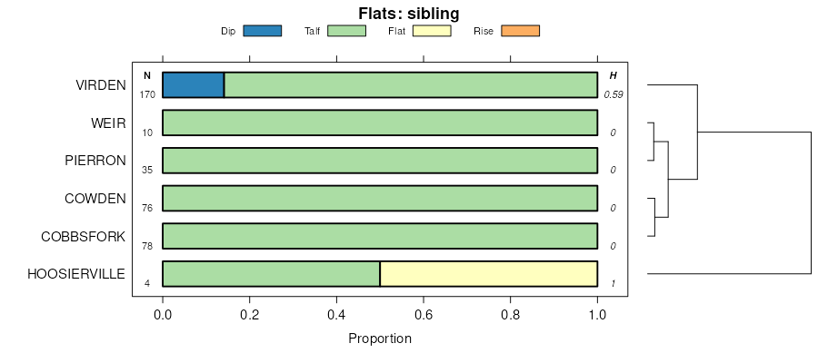
Stoy silt loam, 0 to 2 percent slopes | SvgA | 1897 | 1907355 | 220rl | in071 | 1985 | 1:15840 |
Bedford-Stoy silt loams, 1 to 4 percent slopes complex | BdyB | 1458 | 1651529 | 1sfk4 | in093 | 1982 | 1:15840 |
Stoy silt loam, 0 to 2 percent slopes | SvgA | 781 | 1651548 | 1sfkr | in093 | 1982 | 1:15840 |


