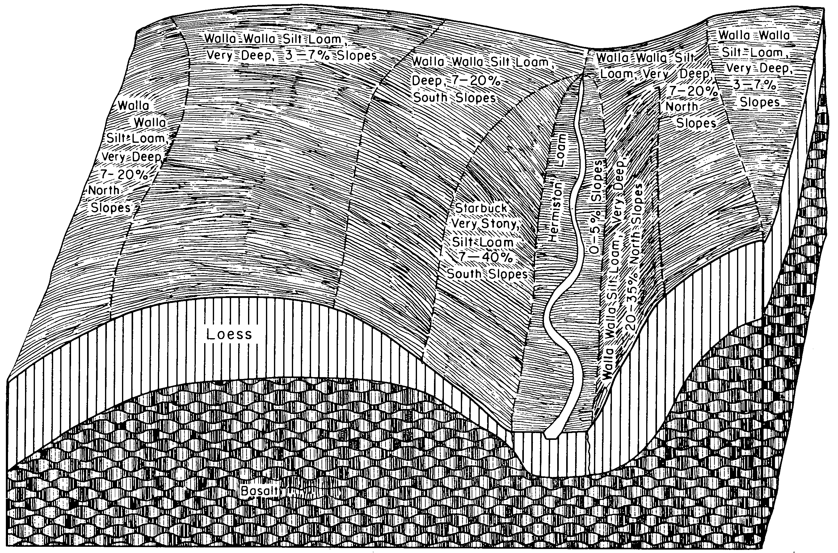
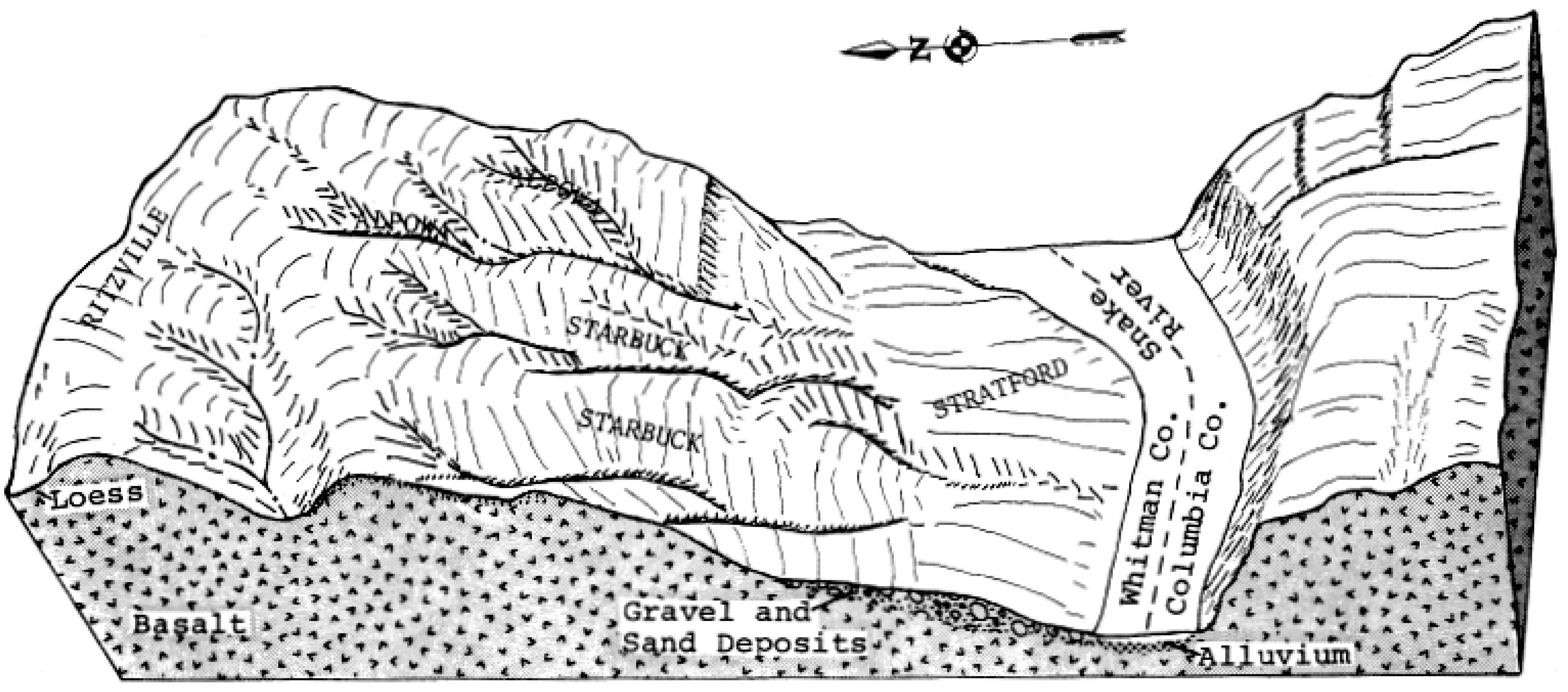
| Starbuck-McPan-Rock outcrop complex, 2 to 20 percent slopes | 181 | 86134 | 81916 | 2r7g | id681 | 1993 | 1:24000 |
Paulville-McPan-Starbuck complex, 1 to 8 percent slopes | 141 | 55560 | 81872 | 2r61 | id681 | 1993 | 1:24000 |
Starbuck-Sidlake-Rock outcrop complex, 2 to 15 percent slopes | 183 | 55160 | 81918 | 2r7j | id681 | 1993 | 1:24000 |
Sidlake-Rock outcrop-Starbuck complex, 2 to 12 percent slopes | 166 | 37565 | 81899 | 2r6x | id681 | 1993 | 1:24000 |
Starbuck-Lava flows complex, 2 to 20 percent slopes | 180 | 23015 | 81915 | 2r7f | id681 | 1993 | 1:24000 |
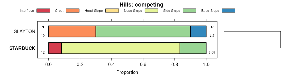
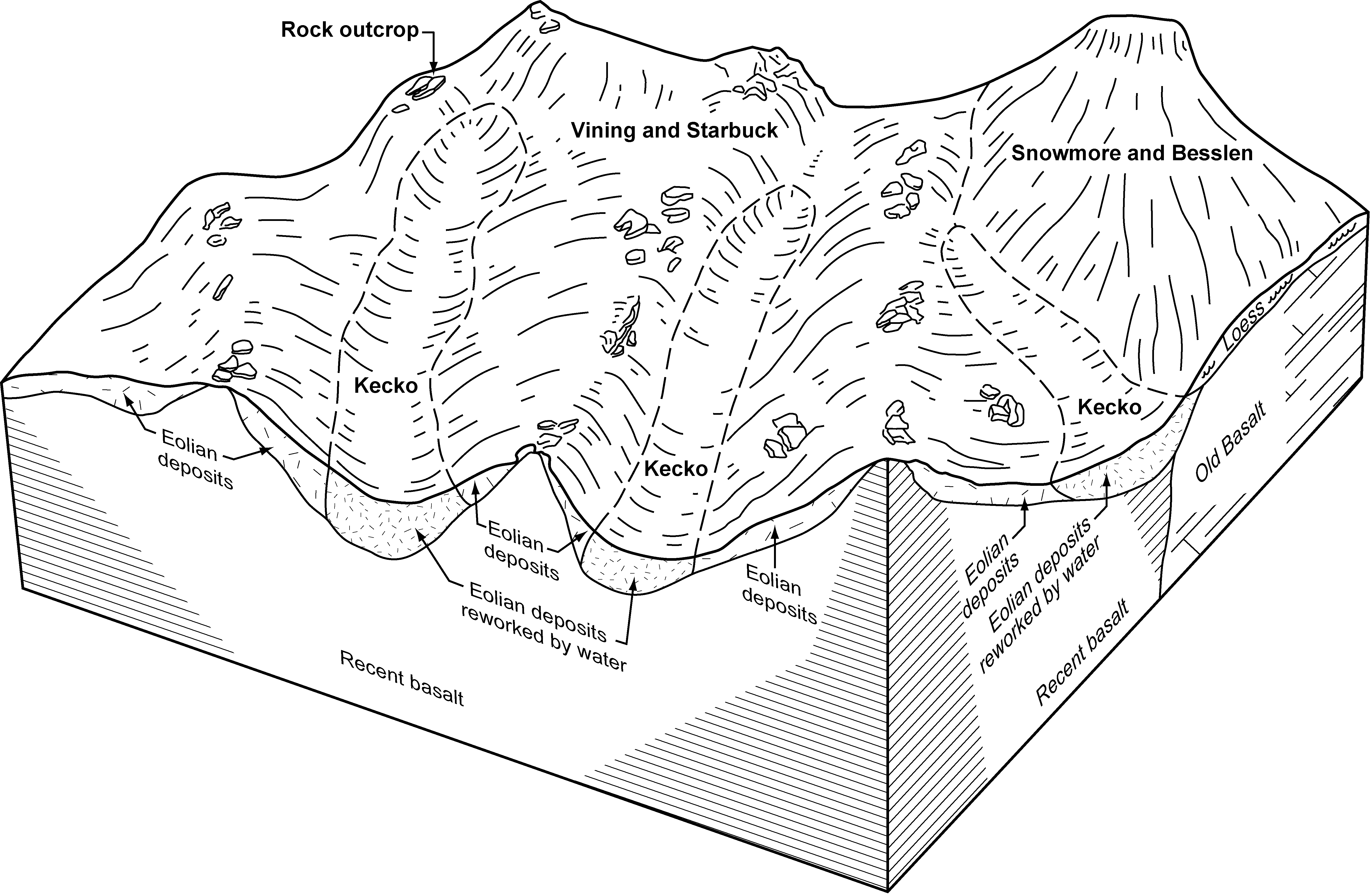
Vining-Kecko-Starbuck complex, 2 to 12 percent slopes | 207 | 15360 | 81945 | 2r8d | id681 | 1993 | 1:24000 |
Sidlake-Starbuck complex, 1 to 8 percent slopes | 167 | 12825 | 81900 | 2r6y | id681 | 1993 | 1:24000 |
Starbuck-Rock outcrop-McPan complex, 2 to 6 percent slopes | 182 | 3580 | 81917 | 2r7h | id681 | 1993 | 1:24000 |
Power-Starbuck-Rock outcrop complex, 0 to 6 percent slopes | 150 | 3235 | 81882 | 2r6c | id681 | 1993 | 1:24000 |
McPan-Starbuck complex, 1 to 4 percent slopes | 125 | 2570 | 81854 | 2r5g | id681 | 1993 | 1:24000 |
McPan-Starbuck complex, 4 to 20 percent slopes | 126 | 2545 | 81855 | 2r5h | id681 | 1993 | 1:24000 |
Jestrick-Starbuck-Kecko complex, 1 to 6 percent slopes | 93 | 970 | 82148 | 2rgy | id681 | 1993 | 1:24000 |
Starbuck-McPan-Rock outcrop complex, 2 to 20 percent slopes | 38 | 14914 | 80095 | 2pbq | id702 | 1999 | 1:24000 |
Barrymore-Starbuck complex, 1 to 4 percent slopes | 8 | 735 | 80065 | 2p9r | id702 | 1999 | 1:24000 |
Barrymore-Starbuck complex, 1 to 4 percent slopes | 18 | 23876 | 80220 | 2pgr | id704 | 1992 | 1:24000 |
Starbuck-McPan-Rock outcrop complex, 2 to 20 percent slopes | 74 | 31756 | 1532660 | 1nfvn | id780 | 1998 | 1:24000 |
Starbuck-Lava flows complex, 2 to 20 percent slopes | 73 | 6885 | 1532658 | 1nfvl | id780 | 1998 | 1:24000 |
Paulville-McPan-Starbuck complex, 1 to 8 percent slopes | 53 | 4738 | 1531744 | 1ndx3 | id780 | 1998 | 1:24000 |
Starbuck-Rock outcrop complex, 0 to 5 percent slopes | 94A | 3974 | 64588 | 256h | or667 | 1984 | 1:20000 |
Starbuck very fine sandy loam, 2 to 20 percent slopes | 93B | 996 | 64587 | 256g | or667 | 1984 | 1:20000 |
Prosser-Starbuck very rocky very fine sandy loams, 0 to 20 percent slopes | PtD | 21321 | 68194 | 28yt | wa001 | 1965 | 1:20000 |
Roloff-Starbuck stony silt loams, 10 to 30 percent slopes | RSD | 15787 | 68215 | 28zh | wa001 | 1965 | 1:20000 |
Roloff-Starbuck extremely rocky silt loams, 0 to 15 percent slopes | RUC | 8254 | 68217 | 28zk | wa001 | 1965 | 1:20000 |
Roloff-Starbuck very rocky silt loams, 10 to 30 percent slopes | RTD | 5242 | 68216 | 28zj | wa001 | 1965 | 1:20000 |
Prosser-Starbuck extremely rocky very fine sandy loams, 0 to 20 percent slopes | PuD | 3055 | 68195 | 28yv | wa001 | 1965 | 1:20000 |
Prosser-Starbuck very rocky very fine sandy loams, 0 to 20 percent slopes | PTC | 2636 | 68190 | 28yp | wa001 | 1965 | 1:20000 |
Starbuck silt loam, 0 to 15 percent slopes | STC | 2349 | 68244 | 290f | wa001 | 1965 | 1:20000 |
Prosser-Starbuck very fine sandy loams, 0 to 5 percent slopes | PsB | 754 | 68193 | 28ys | wa001 | 1965 | 1:20000 |
Prosser-Starbuck very fine sandy loams, 0 to 5 percent slopes | PSB | 753 | 68189 | 28yn | wa001 | 1965 | 1:20000 |
Starbuck-Bakeoven-Rock outcrop complex, 0 to 45 percent slopes | 362 | 13 | 699516 | rgx1 | wa017 | 1998 | 1:12000 |
Prosser-Starbuck complex, 15 to 45 percent slopes | 271 | 5 | 699468 | rgvh | wa017 | 1998 | 1:12000 |
Prosser-Starbuck-Rock outcrop complex, 2 to 15 percent slopes | 83 | 18092 | 71884 | 2dsv | wa021 | 1994 | 1:20000 |
Starbuck-Roloff-Rock outcrop complex, 15 to 30 percent slopes | 171 | 11318 | 71610 | 2dj0 | wa021 | 1994 | 1:20000 |
Starbuck-Prosser-Rock outcrop complex, 15 to 30 percent slopes | 169 | 9795 | 71606 | 2dhw | wa021 | 1994 | 1:20000 |
Starbuck-Prosser-Finley complex, 0 to 25 percent slopes | 168 | 7892 | 71605 | 2dhv | wa021 | 1994 | 1:20000 |
Prosser-Starbuck-Rock outcrop complex, droughty, 2 to 15 percent slopes | 84 | 3621 | 71886 | 2dsx | wa021 | 1994 | 1:20000 |
Starbuck silt loam, 0 to 15 percent slopes | 166 | 3070 | 71603 | 2dhs | wa021 | 1994 | 1:20000 |
Starbuck-Prosser-Rock outcrop complex, droughty, 15 to 30 percent slopes | 170 | 1612 | 71609 | 2dhz | wa021 | 1994 | 1:20000 |
Finley-Burbank-Starbuck complex, 0 to 10 percent slopes | 26 | 1019 | 71696 | 2dls | wa021 | 1994 | 1:20000 |
Kiona-Prosser-Starbuck complex, 30 to 60 percent slopes | 48 | 872 | 71763 | 2dny | wa021 | 1994 | 1:20000 |
Starbuck-Prosser complex, 0 to 15 percent slopes | 167 | 405 | 71604 | 2dht | wa021 | 1994 | 1:20000 |
Starbuck fine sandy loam, 0 to 15 percent slopes | 165 | 364 | 71602 | 2dhr | wa021 | 1994 | 1:20000 |
Starbuck-Bakeoven-Rock outcrop complex, 0 to 45 percent slopes | 143 | 65576 | 68739 | 29jd | wa025 | 1979 | 1:24000 |
Starbuck-Prosser complex, 0 to 25 percent slopes | 145 | 24422 | 68741 | 29jg | wa025 | 1979 | 1:24000 |
Prosser-Starbuck very fine sandy loams, 0 to 15 percent slopes | 94 | 10437 | 68873 | 29nq | wa025 | 1979 | 1:24000 |
Starbuck very fine sandy loam, 0 to 15 percent slopes | 141 | 9390 | 68737 | 29jb | wa025 | 1979 | 1:24000 |
Starbuck-Kiona stony silt loams, 30 to 65 percent slopes | 144 | 6642 | 68740 | 29jf | wa025 | 1979 | 1:24000 |
Starbuck stony silt loam, 0 to 30 percent slopes | 142 | 5399 | 68738 | 29jc | wa025 | 1979 | 1:24000 |
Prosser-Starbuck complex, 15 to 45 percent slopes | 95 | 2741 | 68874 | 29nr | wa025 | 1979 | 1:24000 |
Starbuck cobbly silt loam, 0 to 20 percent slopes | 75 | 12820 | 68675 | 29gb | wa043 | 1978 | 1:24000 |
Starbuck-Alpowa complex, 30 to 65 percent slopes | 95 | 13537 | 68596 | 29cs | wa075 | 1975 | 1:20000 |
Roloff-Starbuck complex, 0 to 30 percent slopes | 86 | 7433 | 68586 | 29cg | wa075 | 1975 | 1:20000 |
Starbuck silt loam, 0 to 5 percent slopes | SrB | 4512 | 69598 | 2bf3 | wa605 | 1965 | 1:20000 |
Starbuck rocky silt loam, 5 to 45 percent slopes | SsE | 4106 | 69601 | 2bf6 | wa605 | 1965 | 1:20000 |
Starbuck stony silt loam, 0 to 15 percent slopes | StD | 3118 | 69602 | 2bf7 | wa605 | 1965 | 1:20000 |
Starbuck silt loam, 0 to 8 percent slopes | SrBC | 2723 | 69599 | 2bf4 | wa605 | 1965 | 1:20000 |
Starbuck silt loam, 5 to 8 percent slopes | SrC | 618 | 69600 | 2bf5 | wa605 | 1965 | 1:20000 |
Starbuck-Rock outcrop complex, 0 to 45 percent slopes | 378 | 1757 | 76313 | 2kdq | wa639 | 2003 | 1:24000 |
Starbuck rocky silt loam, 0 to 30 percent slopes | SyD | 952 | 71446 | 2dbq | wa671 | 1961 | 1:31680 |
Starbuck rocky silt loam, 30 to 45 percent slopes | SyE | 455 | 71447 | 2dbr | wa671 | 1961 | 1:31680 |
Starbuck-Rock outcrop complex, 0 to 45 percent slopes | 143 | 17714 | 68929 | 29qj | wa677 | 1979 | 1:24000 |
Starbuck silt loam, 2 to 15 percent slopes | 142 | 13284 | 68928 | 29qh | wa677 | 1979 | 1:24000 |
Starbuck-Rock outcrop complex, 45 to 60 percent slopes | 144 | 3289 | 68930 | 29qk | wa677 | 1979 | 1:24000 |
Starbuck-Rock outcrop complex, 3 to 15 percent slopes | 149 | 1422 | 70815 | 2cpc | wa681 | 1994 | 1:24000 |
Starbuck-Rock outcrop complex, 45 to 60 percent slopes | 211 | 324 | 71266 | 2d4x | wa681 | 1994 | 1:24000 |
Starbuck-Rock outcrop complex, 0 to 45 percent slopes | 210 | 261 | 71265 | 2d4w | wa681 | 1994 | 1:24000 |