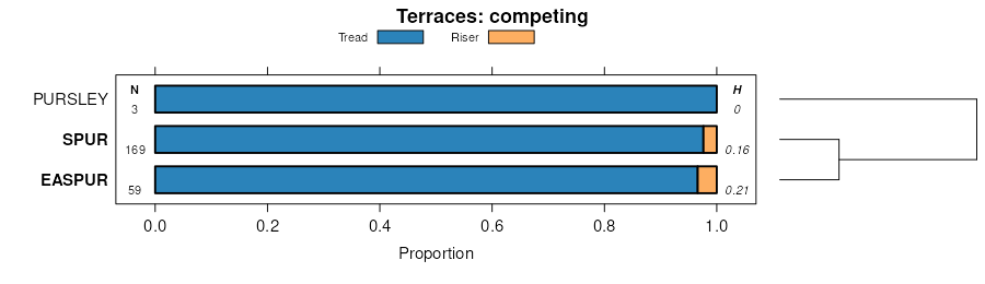
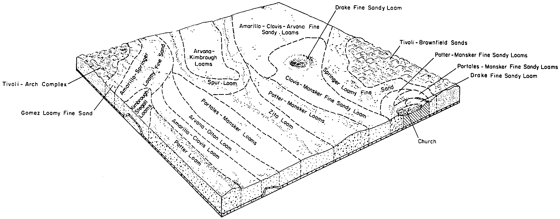
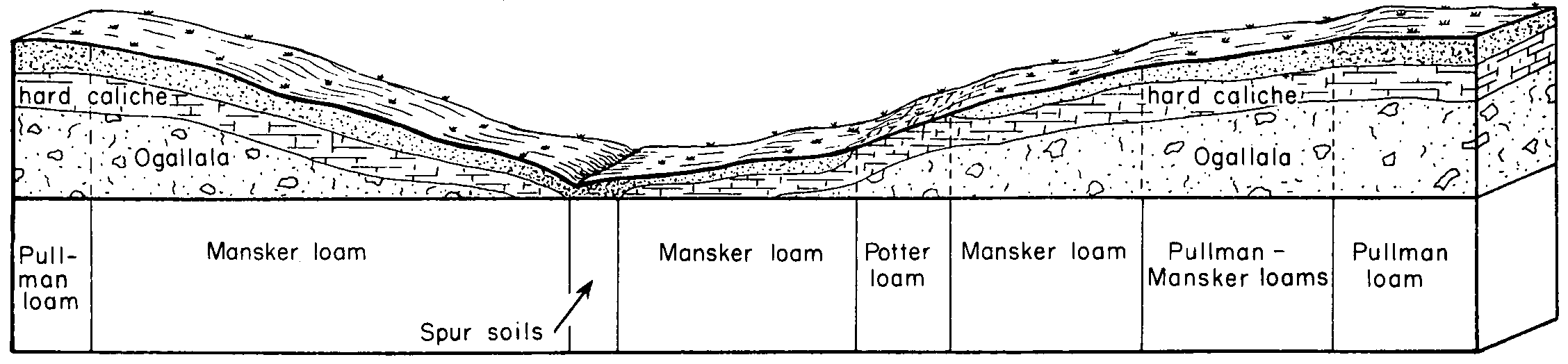
| Spur loam, moist, 0 to 1 percent slopes, rarely flooded | SprA | 747 | 3101277 | 2wt73 | ok007 | 2021 | 1:24000 |
Spur loam, moist, 0 to 1 percent slopes, occasionally flooded | 50 | 3465 | 381689 | 2wt6w | ok009 | 1978 | 1:24000 |
Spur clay loam, 0 to 1 percent slopes, frequently flooded | 51 | 3102 | 381690 | 2wt71 | ok009 | 1978 | 1:24000 |
Spur clay loam, 0 to 1 percent slopes, occasionally flooded, cool | Sa | 20223 | 382076 | 2w84g | ok025 | 1958 | 1:20000 |
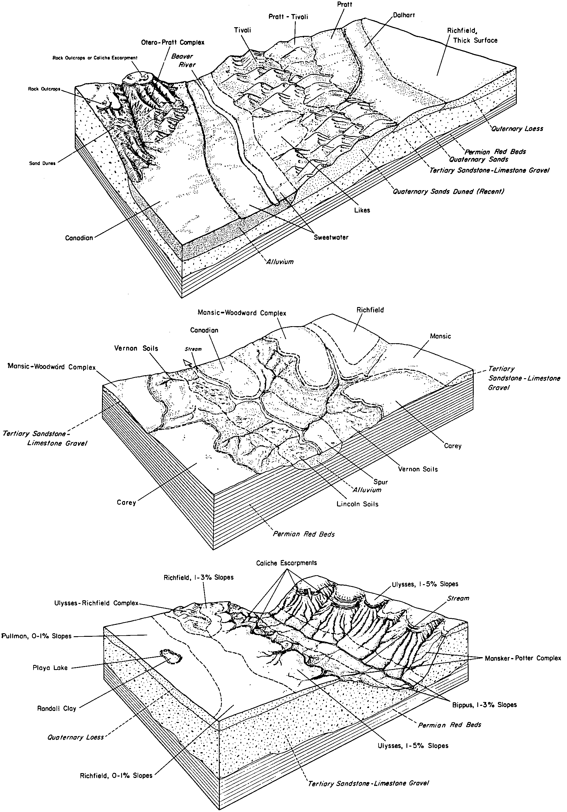
Berda-Spur complex, 0 to 12 percent slopes | Bk | 26737 | 382421 | dty5 | ok045 | 1963 | 1:24000 |
Spur loam, moist, 0 to 1 percent slopes, rarely flooded | Sp | 3870 | 382470 | 2wt73 | ok045 | 1963 | 1:24000 |
Spur clay loam, 0 to 1 percent slopes, occasionally flooded | SuuA | 12388 | 648182 | 2vt8t | ok055 | 2005 | 1:24000 |
Spur clay loam, 0 to 1 percent slopes, frequently flooded | SuwA | 5816 | 648183 | 2wt71 | ok055 | 2005 | 1:24000 |
Spur clay loam, 0 to 1 percent slopes, rarely flooded | SurA | 3107 | 648181 | 2wt6v | ok055 | 2005 | 1:24000 |
Spur loam, moist, 0 to 1 percent slopes, occasionally flooded | SplA | 2756 | 648619 | 2wt6w | ok055 | 2005 | 1:24000 |
Spur clay loam, 0 to 1 percent slopes, occasionally flooded | 53 | 2489 | 975488 | 2vt8t | ok057 | 1982 | 1:24000 |
Spur clay loam, 0 to 1 percent slopes, frequently flooded | 54 | 2126 | 975489 | 2wt71 | ok057 | 1982 | 1:24000 |
Spur loam, moist, 0 to 1 percent slopes, rarely flooded | SprA | 3289 | 383119 | 2wt73 | ok059 | 1998 | 1:24000 |
Spur loam, saline, 0 to 1 percent slopes, rarely flooded | SpsA | 807 | 383121 | dvnr | ok059 | 1998 | 1:24000 |
Spur clay loam, 0 to 1 percent slopes, occasionally flooded | SuuA | 19487 | 392399 | 2vt8t | ok065 | 2000 | 1:24000 |
Spur clay loam, 0 to 1 percent slopes, rarely flooded | SurA | 8468 | 392362 | 2wt6v | ok065 | 2000 | 1:24000 |
Spur clay loam, 0 to 1 percent slopes, frequently flooded | SuwA | 6126 | 392398 | 2wt71 | ok065 | 2000 | 1:24000 |
Spur clay loam, 0 to 1 percent slopes, occasionally flooded, cool | Sp | 10233 | 384922 | 2w84g | ok139 | 1959 | 1:24000 |
Colorado and Spur soils, 0 to 1 percent slopes, frequently flooded | Co | 31496 | 362947 | 2wt6x | tx033 | 1970 | 1:24000 |
Colorado and Spur soils, 0 to 1 percent slopes, occasionally flooded | CSA | 9719 | 2962334 | f6ky | tx033 | 1970 | 1:24000 |
Spur clay loam, 0 to 1 percent slopes, occasionally flooded | Sp | 6026 | 362970 | 2vt8t | tx033 | 1970 | 1:24000 |
Spur loam, 0 to 1 percent slopes, occasionally flooded | Sp | 810 | 363299 | 2wt6y | tx045 | 1972 | 1:20000 |
Spur clay loam, 0 to 1 percent slopes, occasionally flooded | Nc | 2756 | 363834 | 2vt8t | tx075 | 1961 | 1:20000 |
Spur clay loam, 0 to 1 percent slopes, rarely flooded | Sp | 4839 | 364127 | 2wt6v | tx087 | 1965 | 1:20000 |
Colorado and Spur soils, 0 to 1 percent slopes, frequently flooded | Sr | 4179 | 364128 | 2wt6x | tx087 | 1965 | 1:20000 |
Spur loam, 0 to 1 percent slopes, frequently flooded | Lm | 6809 | 364713 | 2wt72 | tx107 | 1964 | 1:20000 |
Spur clay loam, 0 to 1 percent slopes, occasionally flooded | Sc | 3178 | 364741 | 2vt8t | tx107 | 1964 | 1:20000 |
Colorado and Spur soils, 0 to 1 percent slopes, occasionally flooded | CSA | 2623 | 393605 | f6ky | tx115 | 2004 | 1:24000 |
Spur fine sandy loam | Sr | 9683 | 365149 | d7z0 | tx125 | 1965 | 1:20000 |
Spur clay loam, 0 to 1 percent slopes, rarely flooded | Sp | 5927 | 365148 | 2wt6v | tx125 | 1965 | 1:20000 |
Spur clay loam, 0 to 1 percent slopes, occasionally flooded, cool | Sc | 704 | 365206 | 2w84g | tx129 | 1975 | 1:24000 |
Wheatwood-Spur loams, 0 to 1 percent slopes, frequently flooded | WSA | 22434 | 3101051 | 1lh5d | tx155 | 2021 | 1:24000 |
Spur loam, 0 to 1 percent slopes, occasionally flooded | SuA | 2275 | 3100898 | 2wt6y | tx155 | 2021 | 1:24000 |
Spur clay loam, 0 to 1 percent slopes, occasionally flooded | Sp | 6020 | 378357 | 2vt8t | tx169 | 1965 | 1:24000 |
Spur fine sandy loam, 0 to 1 percent slopes, occasionally flooded | Su | 2380 | 378358 | 2wt76 | tx169 | 1965 | 1:24000 |
Spur and Guadalupe soils, 0 to 2 percent slopes, occasionally flooded | Sg | 3792 | 391954 | f4vp | tx179 | 1965 | 1:20000 |
Spur clay loam, 0 to 1 percent slopes, occasionally flooded, cool | Sc | 2598 | 391953 | 2w84g | tx179 | 1965 | 1:20000 |
Spur loam | Sm | 6551 | 366962 | d9vh | tx191 | 1965 | 1:20000 |
Spur loam, 0 to 1 percent slopes, frequently flooded | Ld | 610 | 366942 | 2wt72 | tx191 | 1965 | 1:20000 |
Colorado and Spur soils, 0 to 1 percent slopes, frequently flooded | Cd | 11157 | 367126 | 2wt6x | tx197 | 1965 | 1:20000 |
Spur loam, 0 to 1 percent slopes, occasionally flooded | Sm | 1657 | 367459 | dbcj | tx205 | 1973 | 1:24000 |
Spur loam, moist, 0 to 1 percent slopes, occasionally flooded | Sr | 1123 | 367518 | 2wt6w | tx207 | 1960 | 1:20000 |
Spur clay loam, 0 to 1 percent slopes, occasionally flooded, cool | Sp | 3084 | 367589 | 2w84g | tx211 | 1967 | 1:20000 |
Spur clay loam, 0 to 1 percent slopes, frequently flooded, cool | Su | 2352 | 367590 | 2w84f | tx211 | 1967 | 1:20000 |
Spur soils, saline, frequently flooded | Sa | 1116 | 391910 | f4t8 | tx227 | 1965 | 1:24000 |
Spur loam, moist, 0 to 1 percent slopes, occasionally flooded | Sp | 35354 | 368254 | 2wt6w | tx253 | 1966 | 1:20000 |
Spur soils, broken | Sr | 25885 | 368255 | dc66 | tx253 | 1966 | 1:20000 |
Spur loam, occasionally flooded | Sr | 2394 | 394304 | f79h | tx279 | 1960 | 1:20000 |
Spur clay loam, 0 to 1 percent slopes, frequently flooded, cool | Sp | 5721 | 369477 | 2w84f | tx295 | 1971 | 1:24000 |
Spur clay loam, 0 to 1 percent slopes, rarely flooded | Sp | 8076 | 370742 | 2wt6v | tx335 | 1965 | 1:20000 |
Spur clay loam, 0 to 1 percent slopes, frequently flooded, cool | Sp | 3517 | 371102 | 2w84f | tx357 | 1966 | 1:20000 |
Spur clay loam, 0 to 1 percent slopes, occasionally flooded, cool | Sc | 1269 | 371101 | 2w84g | tx357 | 1966 | 1:20000 |
Bippus and Spur soils, 0 to 2 percent slopes, frequently flooded, cool | BSA | 5342 | 3124169 | 2w83m | tx359 | 1978 | 1:24000 |
Bippus and Spur soils, 0 to 2 percent slopes, frequently flooded, cool | BSA | 5834 | 3124213 | 2w83m | tx375 | 1974 | 1:24000 |
Spur clay loam, 0 to 1 percent slopes, occasionally flooded, cool | Sc | 4043 | 371536 | 2w84g | tx393 | 1979 | 1:24000 |
Spur loam, 0 to 1 percent slopes, occasionally flooded | Sp | 24790 | 371787 | 2wt6y | tx399 | 1965 | 1:20000 |
Spur clay loam, 0 to 1 percent slopes, occasionally flooded | Sp | 14329 | 372032 | 2vt8t | tx415 | 1966 | 1:24000 |
Colorado and Spur soils, 0 to 1 percent slopes, frequently flooded | Co | 13854 | 372003 | 2wt6x | tx415 | 1966 | 1:24000 |
Spur fine sandy loam, 0 to 1 percent slopes, occasionally flooded | Sr | 3038 | 372033 | 2wt76 | tx415 | 1966 | 1:24000 |
Rioconcho and Spur soils | Rs | 45558 | 372755 | dhwc | tx451 | 1971 | 1:20000 |


