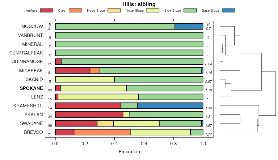
| Spokane ashy loam, 5 to 25 percent slopes | 48 | 1130 | 2487293 | 2ph78 | id057 | 2013 | 1:24000 |
Spokane-Rock outcrop complex, 25 to 65 percent slopes | 49 | 121 | 2487294 | 2ph79 | id057 | 2013 | 1:24000 |
Spokane loam, 30 to 65 percent slopes | 2npp | 4 | 2850883 | 2npp | id604 | 1981 | 1:24000 |
Lenz-Spokane-Rock outcrop association, 30 to 55 percent slopes | 145 | 3611 | 79435 | 2nnf | id606 | 1976 | 1:24000 |
Spokane loam, 30 to 65 percent slopes | 184 | 1251 | 79474 | 2npp | id606 | 1976 | 1:24000 |
Spokane-Moscow association, 35 to 65 percent slopes | 185 | 1055 | 79475 | 2npq | id606 | 1976 | 1:24000 |
Spokane ashy loam, moist, 5 to 30 percent slopes | 183 | 766 | 79473 | 2x1z7 | id606 | 1976 | 1:24000 |
Micapeak-Spokane complex, 30 to 55 percent slopes | 5027 | 112 | 2662891 | 2x1zb | id606 | 1976 | 1:24000 |
Micapeak-Spokane complex, 15 to 30 percent slopes | 5026 | 71 | 2662890 | 2x1z9 | id606 | 1976 | 1:24000 |
Spokane-Swakane complex, 15 to 30 percent slopes | 5041 | 68 | 3099060 | 2wcb | id606 | 1976 | 1:24000 |
Spokane-Kramerhill complex, 25 to 40 percent slopes | 5314 | 58 | 2662917 | nvf4 | id606 | 1976 | 1:24000 |
Kramerhill-Spokane complex, 8 to 25 percent slopes | 5313 | 36 | 3099057 | 2wdz | id606 | 1976 | 1:24000 |
Lenz-Spokane complex, 3 to 15 percent slopes | 5070 | 9 | 2662895 | 2wfk | id606 | 1976 | 1:24000 |
Spokane-Moscow association, 35 to 65 percent slopes | 2npq | 691 | 2936639 | 2npq | id670 | | 1:24000 |
Spokane loam, 30 to 65 percent slopes | 2npp | 257 | 2936634 | 2npp | id670 | | 1:24000 |
Spokane loam, 5 to 30 percent slopes | 2npn | 127 | 2936655 | 2npn | id670 | | 1:24000 |
Spokane-Rock outcrop complex, very steep | 72 | 9001 | 68672 | 29g7 | wa043 | 1978 | 1:24000 |
Spokane ashy loam, 5 to 30 percent slopes | 69 | 4037 | 68668 | 2x1z6 | wa043 | 1978 | 1:24000 |
Spokane very stony loam, 30 to 55 percent slopes | 71 | 3575 | 68671 | 29g6 | wa043 | 1978 | 1:24000 |
Spokane very stony loam, 5 to 30 percent slopes | 70 | 684 | 68670 | 29g5 | wa043 | 1978 | 1:24000 |
Kramerhill-Spokane complex, 8 to 25 percent slopes | 5313 | 11901 | 85931 | 2wdz | wa063 | 2012 | 1:24000 |
Micapeak-Spokane complex, 15 to 30 percent slopes | 5026 | 4775 | 85902 | 2x1z9 | wa063 | 2012 | 1:24000 |
Lenz-Spokane complex, 3 to 15 percent slopes | 5070 | 4427 | 85949 | 2wfk | wa063 | 2012 | 1:24000 |
Lenz-Spokane complex, 15 to 30 percent slopes | 5071 | 4085 | 85867 | 2wbx | wa063 | 2012 | 1:24000 |
Micapeak-Spokane complex, 30 to 55 percent slopes | 5027 | 3212 | 85903 | 2x1zb | wa063 | 2012 | 1:24000 |
Spokane-Kramerhill complex, 25 to 40 percent slopes | 5314 | 3083 | 621213 | nvf4 | wa063 | 2012 | 1:24000 |
Spokane-Swakane complex, 3 to 15 percent slopes | 5040 | 2651 | 680683 | qv9j | wa063 | 2012 | 1:24000 |
Spokane-Swakane complex, 15 to 30 percent slopes | 5041 | 1734 | 85880 | 2wcb | wa063 | 2012 | 1:24000 |
Spokane-Rock outcrop complex, 30 to 55 percent slopes | 5037 | 1003 | 85940 | 2wf8 | wa063 | 2012 | 1:24000 |
Urban land-Spokane, disturbed complex, 15 to 30 percent slopes | 7197 | 296 | 2425269 | 2mdph | wa063 | 2012 | 1:24000 |
Spokane-Rock outcrop complex, 40 to 65 percent slopes | 224 | 14695 | 158195 | 59m2 | wa065 | 1978 | 1:24000 |
Spokane stony loam, 0 to 40 percent slopes | 221 | 9871 | 158192 | 59lz | wa065 | 1978 | 1:24000 |
Spokane-Rock outcrop complex, 0 to 40 percent slopes | 223 | 8890 | 158194 | 59m1 | wa065 | 1978 | 1:24000 |
Spokane stony loam, 40 to 65 percent slopes | 222 | 7349 | 158193 | 59m0 | wa065 | 1978 | 1:24000 |
Spokane loam, 25 to 40 percent slopes | 219 | 7236 | 158189 | 59lw | wa065 | 1978 | 1:24000 |
Rock outcrop-Spokane complex, 30 to 65 percent slopes | 196 | 5730 | 158163 | 59l1 | wa065 | 1978 | 1:24000 |
Spokane loam, 0 to 25 percent slopes | 218 | 5452 | 158188 | 59lv | wa065 | 1978 | 1:24000 |
Spokane ashy loam, 40 to 65 percent slopes | 220 | 1765 | 158191 | 2x1z5 | wa065 | 1978 | 1:24000 |
Lenz-Spokane complex, 3 to 15 percent slopes | 5070 | 121 | 2651324 | 2wfk | wa065 | 1978 | 1:24000 |
Spokane-Swakane complex, 3 to 15 percent slopes | 5040 | 92 | 2651321 | qv9j | wa065 | 1978 | 1:24000 |
Spokane-Rock outcrop complex, 30 to 55 percent slopes | 5037 | 61 | 2651320 | 2wf8 | wa065 | 1978 | 1:24000 |
Micapeak-Spokane complex, 15 to 30 percent slopes | 5026 | 38 | 2651319 | 2x1z9 | wa065 | 1978 | 1:24000 |
Lenz-Spokane complex, 15 to 30 percent slopes | 5071 | 17 | 2651325 | 2wbx | wa065 | 1978 | 1:24000 |
Spokane loam, 20 to 40 percent slopes | 440 | 10188 | 70590 | 2cg3 | wa648 | 1987 | 1:24000 |
Spokane loam, 5 to 20 percent slopes | 439 | 4582 | 70588 | 2cg1 | wa648 | 1987 | 1:24000 |
Spokane ashy loam, 40 to 65 percent slopes | 441 | 2918 | 70591 | 2x1z5 | wa648 | 1987 | 1:24000 |
Spokane, warm-Skanid, warm complex, 20 to 40 percent slopes | 447 | 1971 | 70597 | 2cgb | wa648 | 1987 | 1:24000 |
Spokane, warm-Skanid, warm complex, 5 to 20 percent slopes | 446 | 1971 | 70596 | 2cg9 | wa648 | 1987 | 1:24000 |
Spokane, warm-Skanid, warm complex, 40 to 65 percent slopes | 448 | 1838 | 70598 | 2cgc | wa648 | 1987 | 1:24000 |
Spokane-Rock outcrop complex, 20 to 40 percent slopes | 445 | 1030 | 70595 | 2cg8 | wa648 | 1987 | 1:24000 |
Spokane loam, warm, 20 to 40 percent slopes | 442 | 992 | 70592 | 2cg5 | wa648 | 1987 | 1:24000 |
Spokane loam, warm, 40 to 65 percent slopes | 443 | 659 | 70593 | 2cg6 | wa648 | 1987 | 1:24000 |
Spokane-Rock outcrop complex, 5 to 20 percent slopes | 444 | 325 | 70594 | 2cg7 | wa648 | 1987 | 1:24000 |


